Last updated: August 29, 2023
Article
NPS Geodiversity Atlas—Pecos National Historical Park, New Mexico
Geodiversity refers to the full variety of natural geologic (rocks, minerals, sediments, fossils, landforms, and physical processes) and soil resources and processes that occur in the park. A product of the Geologic Resources Inventory, the NPS Geodiversity Atlas delivers information in support of education, Geoconservation, and integrated management of living (biotic) and non-living (abiotic) components of the ecosystem.
Introduction
Pecos National Historical Park (NHP) preserves 12,000 years of human history at a cultural crossroads in north-central New Mexico. Originally established in 1965 as Pecos National Monument to preserve the remains and artifacts of an ancient Indian pueblo and seventeenth-century Spanish mission, the park was expanded in 1990 to commemorate the multi-themed history of the larger Pecos area, including the cultural interaction among diverse groups of people in this "gateway" between the Great Plains and the Rio Grande valley, and to preserve and interpret the Battle of Glorieta Pass, a key event the Civil War in the Far West.
Pecos Unit
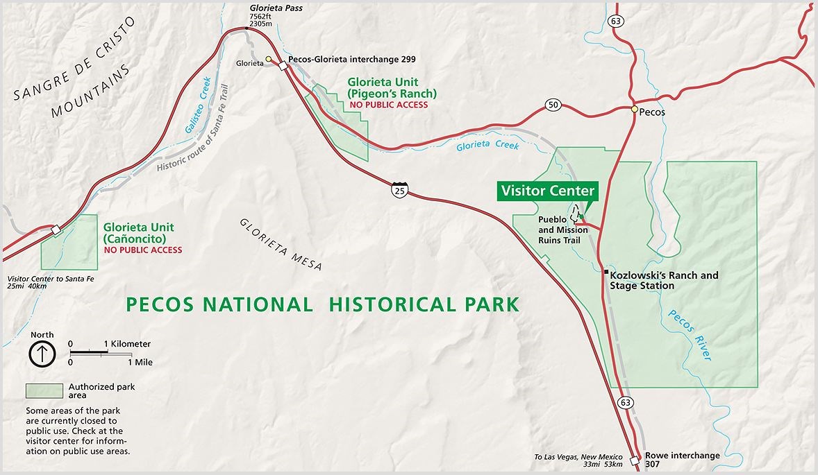
The approximately 5,000-acre Pecos Unit contains the original 341-acre monument protecting the Pecos Pueblo and Spanish mission as well as Forked Lighting Ranch, a 1900s-ranch whose cultural and natural resources interpret the area’s history of cattle ranching.
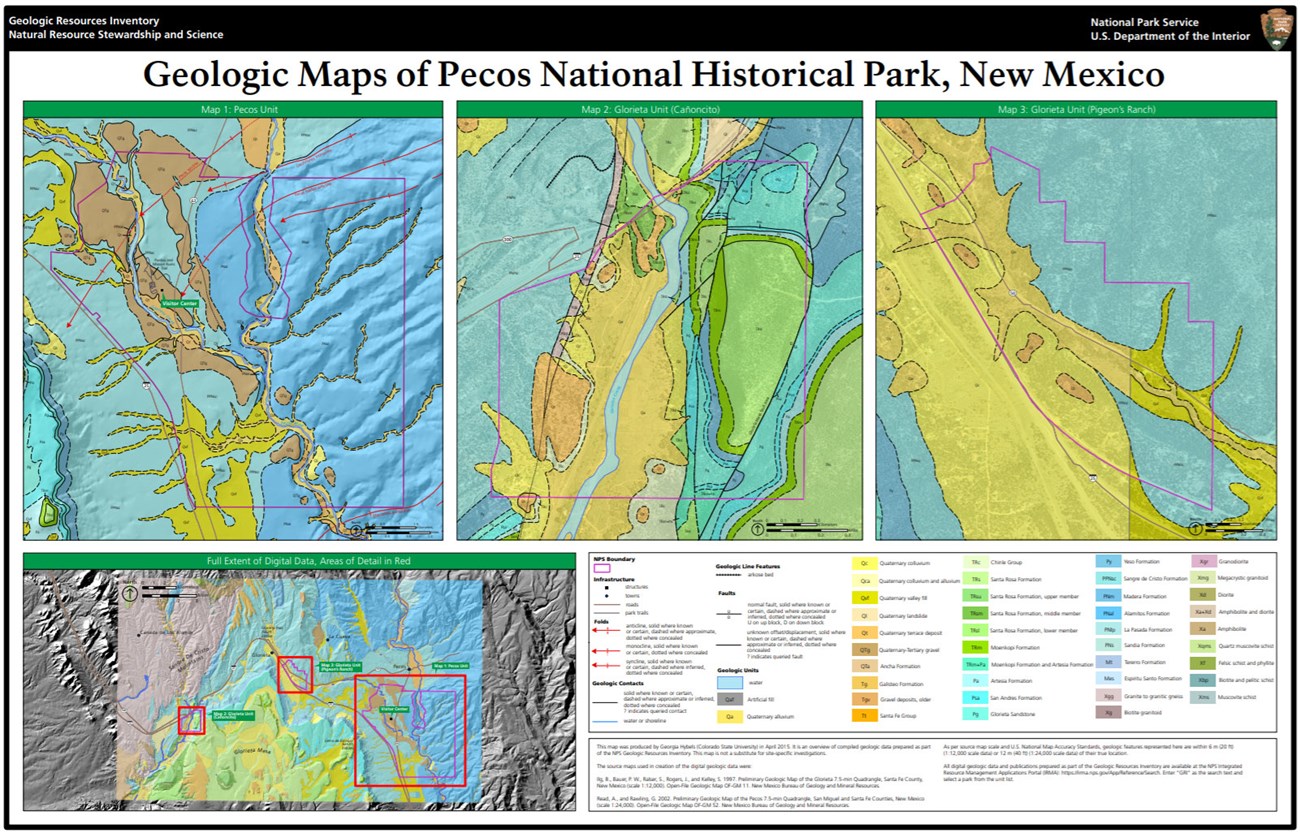
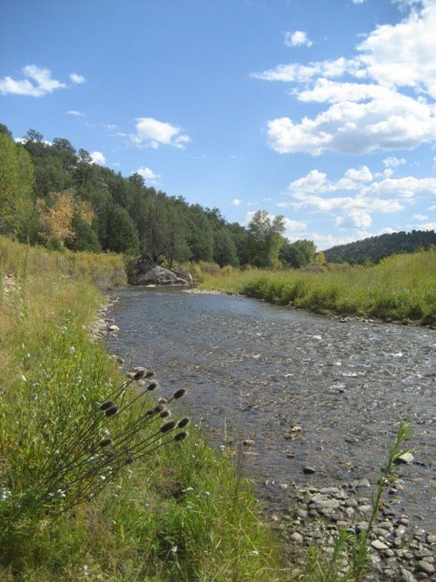
The Paleozoic Alamitos and Sangre de Cristo formations are exposed at the surface in most of the unit, except where covered by Tertiary gravels and Quaternary deposits. The Pecos River flows north-south through the unit. Glorieta Creek, flowing down from its headwaters near Glorieta Pass, meets the Pecos River within the unit.
Glorieta Unit
The 682-acre Glorieta Unit consists of two subunits: Cañoncito, containing the site of the Confederate Army camp, and Pigeon’s Ranch, containing the main battle site.
Glorieta Creek flows through the Pigeon’s Ranch Subunit. The Sangre de Cristo Formation is exposed in at the surface of Pigeon’s Ranch in areas that are not covered by Quaternary colluvium, alluvium, or terraces.
The Cañoncito Subunit has the most complex and diverse geology within Pecos NHP. Rock units ranging in age from the Proterozoic to the Triassic are exposed. The area is cut by faults related to the Picuris-Pecos fault zone. Quaternary deposits are associated with Galisteo Creek which runs through the subunit.
Geologic Setting and Regional Geology
NPS image by Rebecca Port.
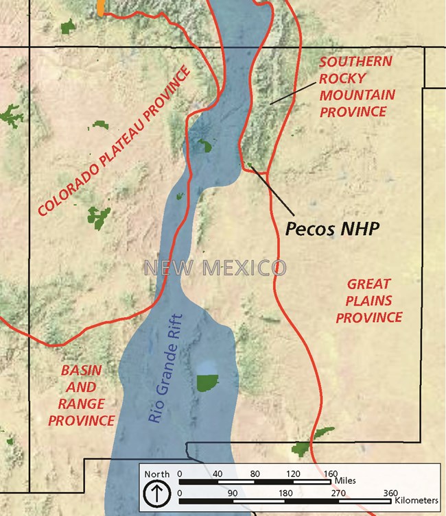
Pecos NHP is in a broad rolling valley between the Sangre de Cristo Mountains and Glorieta Mesa and is at a geologic crossroads where three physiographic provinces meet. Just to the north are the Sangre de Cristo Mountains, which are the southern terminus of the Southern Rocky Mountains. Just to the west is the Rio Grande Rift, part of the Basin and Range. And the Great Plains are to the south and east.
Glorieta Pass is a natural route to Santa Fe, which was the terminus of the Santa Fe Trail, as well an important trading center for goods coming from the south. The Santa Fe Trail utilized the Pecos River drainage once it exited the Great Plains and began the ascent to Glorieta Pass. The trail then followed Glorieta Creek to the divide. Santa Fe, which is about 30 miles to the northwest, is within the Rio Grande Rift.
The Sangre de Cristo Mountains were uplifted during the Laramide Orogeny, approximately 40-70 million years ago. The Sangre de Cristo Mountains are a north–south trending range that extends from south-central Colorado to northern New Mexico. The eastern portion of the Pecos Unit and the Pigeon’s Ranch Subunit contain some of the southern foothills of the Sangre de Cristo Mountains.
The transition from the Southern Rocky Mountains to the Great Plains is perhaps the most dramatic boundary between physiographic provinces in North America. Glorieta Mesa, south of Pecos NHP, is part of the Great Plains. It rises 1,200 feet (375 m) to reach a maximum elevation of 7,559 ft (2,304 m) and is a major part of the southern viewshed of the Pecos Unit. Glorieta Mesa is made up of gently-dipping Paleozoic and Mesozoic rocks. The main Glorieta Mesa escarpment faces north, and the mesa’s rocks slope gently to the east and south into the Great Plains.
To the southeast, the Pecos Valley subsection of the Great Plains in eastern New Mexico is a broad valley carved by the Pecos River where Paleozoic rocks are exposed at the surface.
A complex fault zone on separates Glorieta Mesa from the Rio Grande Rift to the west. The Rio Grande Rift is a continental rift zone in New Mexico that is part of the Basin and Range physiographic province. The Basin and Range in New Mexico is a series of roughly north-south-trending mountains separated by broad basins. Basin and Range extension in central New Mexico near Albuquerque began about 22 million years ago. The Espanola Basin of the Rio Grande Rift west of Pecos NHP has undergone approximately 10-17% extension.
Geologic Overview
The greater Pecos NHP area has a complex geologic history. Precambrian igneous and metamorphic rocks core the southern Sangre de Cristo Mountains north of Pecos NHP, although there are some exposures of granite and granitic gneiss in a small band in the Cañoncito Subunit. Bedrock exposed in the park consists mostly of late Paleozoic sedimentary rocks, except for some Triassic rocks at Cañoncito.
Late Tertiary (Neogene) gravel deposits consisting of rounded clasts of Precambrian and Paleozoic rocks eroded from the Sangre de Cristo Mountains and formed prior to the modern incision of the Pecos River valley are present in the Pecos Unit. Quaternary units including a variety of alluvial, colluvial, and terrace deposits are mapped in both the Pecos and Glorieta units.
Precambrian igneous and metamorphic rocks are exposed in the Sangre de Cristo Mountains, including granite and granitic gneiss in a narrow zone in the Cañoncito Subunit. These Proterozoic plutonic, metavolcanic, and metasedimentary rocks are roughly 1.6 to more than 1.7 billion years old and were formed during collisions of microcontinents (island chains) with the growing North American continent.
NPS photo by Mario Armijo.
A thick sequence of Pennsylvanian to Triassic rocks are exposed in Pecos NHP and on Glorieta Mesa just to the south. The Alamitos Formation, the oldest sedimentary rock unit in the park, is found at the surface in the eastern half of the Pecos Unit. The Alamitos Formation is part of the Madera Group of Middle to Late Pennsylvanian age (approximately 306 million years old). It consists of gray, fossiliferous marine limestone, interbedded with coarse arkosic sandstone and dark gray to reddish shale with a thickness as much as 1,500 ft (460 m). It was deposited in shallow marine and fluvial environments.
The Alamitos Formation has a gradational contact with overlying the Late Pennsylvian-Early Permian (approximately 280-305 million years old) Sangre de Cristo Formation. The Sange de Cristo Formation consists of variegated mudstones with interbedded sandstones with some limestone and conglomeratic beds with a total thickness reaching 3,000 feet (900 m) near Cañoncito. These sediments were shed off the growing Ancestral Rocky Mountains that were present at the time to the northwest. The Sangre de Cristo Formation is exposed in the western part of the Pecos Unit. It is the only bedrock unit mapped in at Pigeon’s Ranch and is also present in the Cañoncito Subunit.
The Cañoncito Subunit also contains exposures of the Permian Yeso Formation, Glorieta Sandstone, San Andres Formation, and Artesia Formation, along with the Triassic Moenkopi Formation, Santa Rosa Formation, and Chinle Group.
The Yeso Formation overlies the Sangre de Cristo Formation with a conformable contact. The Yeso Formation consists of 160-200 feet (50-60 m) of reddish brown sandstone and siltstone deposited in an intertidal or coastal plain environment with some eolian influences, and is approximately 280 to 270 million years old.
The type section of the Glorieta Sandstone is on Glorieta Mesa where it is a prominent cliff-forming unit. The eolian Glorieta Sandstone is between 80 and 120 feet (25-37 m) thick and consists of clean sand deposited in a coastal sand dune environment with interdunal areas.
The San Andres Formation was deposited in shallow marine conditions. In the Pecos area, the unit is only 15-45 feet (5-14 m) thick, consisting of gray limestone with some interbedded limey sandstone.
The uppermost Permian unit in Pecos NHP contains the orange to brick-red siltstones, sandstones, and gypsum beds of the Artesia Formation, which were deposited approximately 269 to 265 million years ago. In north-central New Mexico, the Artesia Formation was deposited in a marginal marine environment including tidal flats, lagoons, and coastal plains, with reef-forming environments present to the south.
Triassic strata in the Cañoncito Subunit include the Moenkopi Formation, Santa Rosa Formation, and the Chinle Group. The Moenkopi Formation was deposited in fluvial and lacustrine environments and consists of dark red to purplish-red sandstone, conglomerate, mudstone, and siltstone. The unit is 75-120 feet (23-37 m) thick at Glorieta Mesa. It was deposited approximately 247 million years ago, and both its upper and lower contacts are unconformities. The Santa Rosa Formation caps Glorieta Mesa, and area consists of three members in the Pecos area. Lithologies include sandstone, conglomerate, siltstone, mudstone, and limestone, representing floodplain and lacustrine environments and with a total thickness of 250-330 feet (70-100 m).
Rocks of the Late Triassic Chinle Group have been mapped in the western part of the Cañoncito Subunit where the Chinle consists of mudstone, sandstone, and limestone pebble conglomerate with a thickness of approximately 615 feet (187 m).
Tertiary alluvium fill covers much of the valley in the Pecos Unit, including at the Pecos Pueblo and Spanish mission site. These gravels were derived from the eroding Sangre de Cristo Mountains and were deposited in the valley throughout the Neogene and into the early Quaternary. They were deposited prior to the establishment of the incised modern drainage system consisting of the Pecos River and Glorieta Creek. These Tertiary gravels are perched as high as 1,500 feet (460 m) above the Pecos River, and are also found on top of parts of Glorieta Mesa.
Quaternary deposits in the park include alluvium, terrace deposits, and valley fill, and are found along the riverways and drainages in the park.
Folds and Faults
The Pecos area has been impacted by tectonic events that span most of the history of North America as evidenced by the Proterozoic rocks and structures exposed in the Sangre de Cristo Mountains. More recent events such as the uplift of the Sangre de Cristo Mountains and Basin and Range extension have also impacted the region.
At their southern extent, the Sangre de Cristo Mountains are characterized by large asymmetrical folds that plunge to the south or southwest. Several of these folds extend into the Pecos Unit.
The Picuris-Pecos fault cuts through the Cañoncito Subunit. The Picuris-Pecos fault zone has been traced for more than 52 mi (84 km) north-south through New Mexico from the Picuris Mountains south of Taos to south of Cañoncito. It is the arguably the most significant strike-slip fault identified in New Mexico. The fault zone has been reactivated a number of times, from the Proterozoic to the formation of the Rio Grande Rift in the Cenozoic, including activity during the Ancestral Rocky Mountains the Laramide orogenies. The geologic map of the Cañoncito Subunit shows vertical displacement on the fault.
Pecos River & Other Fluvial Features
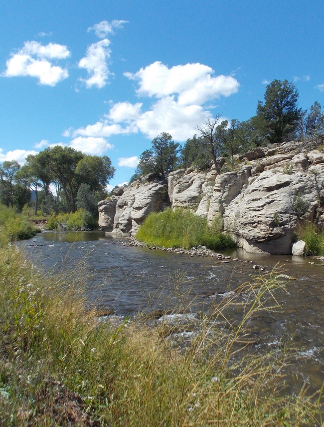
The perennial Pecos River, and the empheral Glorieta and Galisteo creeks, run through Pecos NHP. The Pecos Unit contains an approximately 3.5-mile segment of the Pecos River. The Pecos River headwaters are at 12,000 feet in the Sangre de Cristo Mountains about 30 miles north of the park. Below the park, the river travels more than 900 miles through eastern New Mexico and West Texas to join the Rio Grande a bit upstream of Amistad National Recreation Area.
Glorieta Creek originates near Glorieta Pass. It flows through Pigeon’s Ranch and joins the Pecos River in the Pecos Unit.
Galisteo Creek bisects the Cañoncito Subunit and flows westward to join the Rio Grande at Santo Domingo Pueblo.
Geologic Resources in a Cultural Context
The landscape of the greater Pecos area has had significant impacts on the human history of the region.
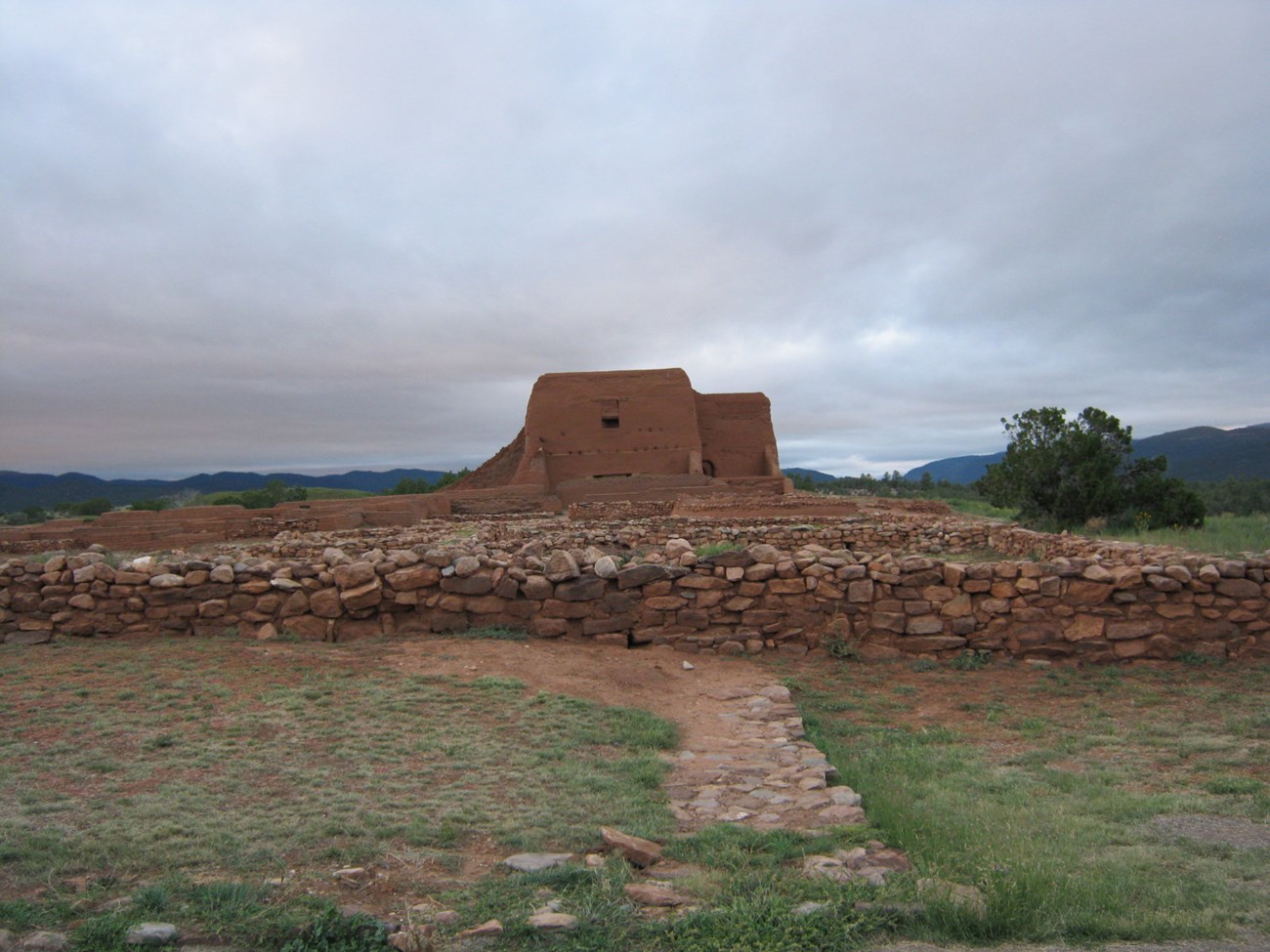
The inhabitants of Pecos Pueblo used geologic resources for producing pottery and stone tools (“lithics”), and as building stone. Walls of the Pecos Pueblo are made of igneous and metamorphic cobbles carried from nearby terraces and Glorieta Creek, as well as blocks from the Sangre de Cristo Formation.
NPS photo by Paul Varela.
The Mission churches are made of adobe bricks. Flagstone used in the church was quarried from the Sangre de Cristo Formation, and selenite or mica (muscovite) was used as windows. Local gypsum was a source for plaster of Paris.
Glorieta Pass has been an important travel route from prehistoric times to the present day. Because of their location near Glorieta Pass, the people of Pecos Pueblo traded with both the Plains Indians and the Rio Grande Puebloans. In 1541, Francisco Vasquez de Coronado traversed the pass in route to explore the plains. The Santa Fe Trail was utilized from the 1820s to the 1880s. Later, the railroad and Interstate 25 took advantage of this natural travel corridor.
The Battle of Glorieta Pass was fought on March 26–28, 1862. Confederate forces had advanced up the Rio Grande Valley and wanted to take control of Fort Union and the Colorado gold fields to the north. At Glorieta Pass, they met the Union Army that had marched down from Colorado. After the battle, the Union forces had to retreat, but the Confederates were defeated after a contingent of Union soldiers had descended down steep and rugged terrain off of Glorieta Mesa and destroyed the lightly guarded Confederate supply train at Cañoncito.
Related Links
Paleontological Resources
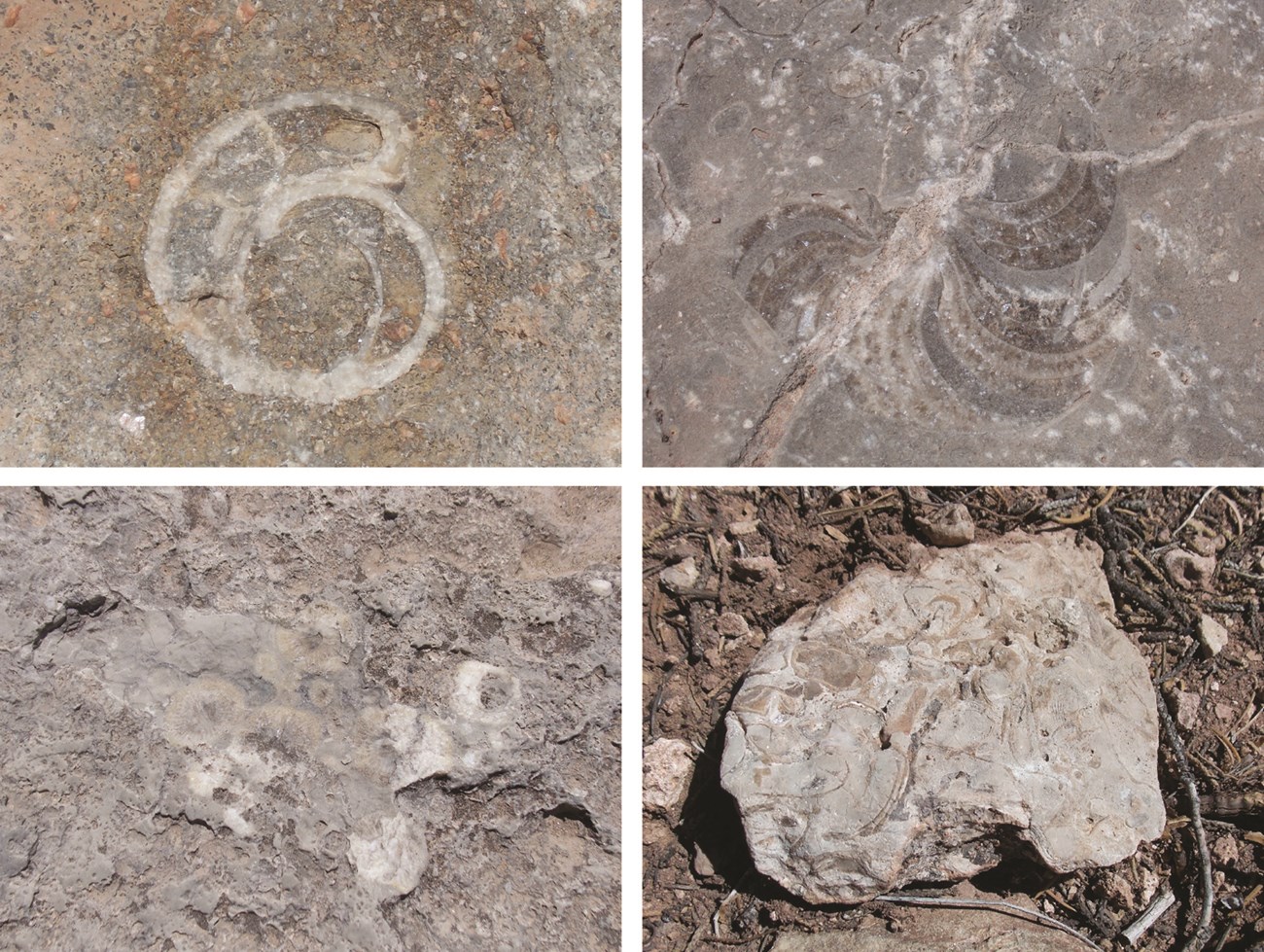
Fossils have been documented only in the Alamitos and Sangre de Cristo formations in Pecos NHP, although most of the other Paleozoic and Mesozoic units present have the potential to contain fossils.
NPS Photo by Mario Armijo.
The Alamitos Formation contains a variety of marine invertebrate fossils including rugose corals, bivalves, ammonites, cephalopods, and possibly gastropods. Vertebrate fossils have been collected from the Sangre de Cristo formation within the park. The Sangre de Cristo also contains substantial terrestrial fossil trackways, but fossil tracks have not been found within the park boundary.
The Neogene and Quaternary deposits may also contain fossils, but have not been identified to date.
A variety of fossils, including brachiopods, crinoids, corals, bivalves, and a mammal tooth, have been recovered from archeological sites in the park.
All NPS fossil resources are protected under the Paleontological Resources Preservation Act of 2009 (Public Law 111-11, Title VI, Subtitle D; 16 U.S.C. §§ 470aaa - 470aaa-11).
Caves and Karst
Two caves are present in Pecos NHP, and both are closed to public visitation. Baca Cave is an Abandoned Mineral Land (AML) site and was a natural opening formed by erosion along a joint (rock fracture) that was enlarged through mining operations. The other cave is a small non-karst opening that also formed along a joint.
Most (98.5%) of the park is underlain by sedimentary rock layers containing limestone and other carbonates and has been identified as being known or potential karst based on the extent of exposure of soluble rocks exposed at the surface or buried at shallow depth. However, no karstic features such as sinkholes or internal drainage are located in the park.
All NPS cave resources are protected under the Federal Cave Resources Protection Act of 1988 (FCRPA)(16 U.S.C. § 4301 et seq.).
Abandoned Mineral Lands
One Abandoned Mineral Lands (AML) site is in Pecos NHP. The Baca Mine likely was either a copper or uranium play and contains an adit and a shaft. It has been fenced to address public safety concerns, and is closed to public visitation.
NPS AML sites can be important cultural resources and habitat, but many pose risks to park visitors and wildlife, and degrade water quality, park landscapes, and physical and biological resources. Be safe near AML sites—Stay Out and Stay Alive!
Geohazards
Natural geologic processes continue to occur in and around Pecos on time scales ranging from seconds to years. Visitors should be cautious and alert to Geohazards that may be present.
Flooding presents a potential hazard along the Pecos River, Glorieta Creek, and Galisteo Creek. Cultural sites are far enough away from the Pecos River that they likely would not be threatened by floods. Slumping, sliding, and rockfalls do occur along the river corridors and may be impacting backcountry areas and cultural resources.
Downcutting and bank erosion are proceeding at accelerated rates along some sections of the Pecos River and Glorieta Creek within the park, and has produced narrow and incised stream channels. This channel morphology may result in loss of riparian habitat, threats to cultural resources, and risk of slope failure.
Emphemeral arroyos may flood during intense storms, causing incision and dramatically eroding their banks, leaving the drainages susceptible to slope movements.
North-central New Mexico has moderate seismic hazard. The USGS 2014 Seismic Hazard Map indicates that the Pecos NHP area has a 2% chance of an earthquake occuring with peak ground acceleration between 14 and 20 %g (percent of gravity) within 50 years. This peak ground acceleration is roughly equivalent to VI to VII on the Modified Mercalli Intensity Scale. The expected number of damaging earthquakes in north-central New Mexico in 10,000 years is between 10 and 20. A M3.0 earthquake occurred in 2013 approximately 5 miles (8 km) west of Cañoncito subunit. A M2.9 earthquake occurred in 2019 approximately 12 mi (20 km) north of the Pecos unit.
Related Links
Regional Geology
Pecos is located at convergence of three physiographic provinces - the Southern Rocky Mountains, Great Plains, and Basin and Range Provinces, and shares its geologic history and some characteristic geologic formations with a region that extends well beyond park boundaries.
- Scoping summaries are records of scoping meetings where NPS staff and local geologists determined the park’s geologic mapping plan and what content should be included in the report.
- Digital geologic maps include files for viewing in GIS software, a guide to using the data, and a document with ancillary map information. Newer products also include data viewable in Google Earth and online map services.
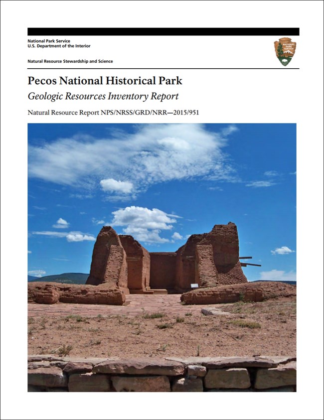
- Reports use the maps to discuss the park’s setting and significance, notable geologic features and processes, geologic resource management issues, and geologic history.
- Posters are a static view of the GIS data in PDF format. Newer posters include aerial imagery or shaded relief and other park information. They are also included with the reports.
- Projects list basic information about the program and all products available for a park.
Source: Data Store Saved Search 3141. To search for additional information, visit the Data Store.
A NPS Soil Resources Inventory project has been completed for Pecos National Historical Park and can be found on the NPS Data Store.
Source: Data Store Saved Search 3092. To search for additional information, visit the Data Store.
Related Articles
Pecos National Historical Park
National Park Service Geodiversity Atlas
The servicewide Geodiversity Atlas provides information on geoheritage and geodiversity resources and values within the National Park System. This information supports science-based geoconservation and interpretation in the NPS, as well as STEM education in schools, museums, and field camps. The NPS Geologic Resources Division and many parks work with National and International geoconservation communities to ensure that NPS abiotic resources are managed using the highest standards and best practices available.
For more information on the NPS Geodiversity Atlas, contact us.

