Last updated: March 26, 2020
Article
Historic Preservation and Resource Documentation at the Abó Painted Rocks Site

NPS.
This study reports on a three-year project between 2008-2010 to record the pictographs and paintings at the Abó Painted Rocks site in Salinas Pueblo Missions National Monument, New Mexico.
The Abó Unit of Salinas Pueblo Missions National Monument, managed by the NPS, is located west of Mountainair, New Mexico. The Abó Unit encompasses the remains of several Native American pueblos dating from the 13th through the 17th centuries, a 17th century Spanish mission, various other prehistoric and historic structures and out-buildings, and a nationally significant pictograph site, Abó Painted Rocks.
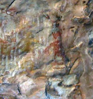
The Abó Painted Rocks consists of numerous prehistoric Native American pictographs and paintings within a shallow rock shelter. The monochrome and polychrome rock art at the Abó Painted Rocks covers a horizontal distance of approximately 115 meters. The site is near the ruins of one of the Salinas pueblos. The countryside surrounding the site was heavily populated by about 1250 AD. The area was abandoned by the time of the Pueblo Revolt in 1680. Rock art is difficult to date, but archeologists assume that the figures were created during this 400-year period. Paintings and pictograph images include handprints, chevrons, local fauna, spirals, turkeys, and anthropomorphic figures.
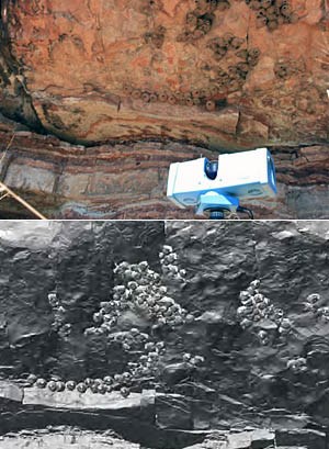
The site is culturally significant to 18 American Indian tribes and the local Hispanic community. The representations, however, are in a severe and rapid state of deterioration. The site is located less than 50m from a major roadway, exposing the site to vibration. The close proximity of the highway also makes the rock art accessible to trespassers, resulting in disturbance and graffiti. The Burlington Northern & Santa Fe Railroad’s Abó Pass Line is a major freight route with constant rail traffic and is less than 200m from the site, dramatically increasing vibration at the site. Carbon monoxide pollution from train and car exhaust is also a major issue. Rock swallows use the shelter for nesting, resulting in numerous mud nests adhering to the Abó Painted Rocks which compromise the integrity of the original fabric/paint. The site is also vulnerable to wildland fires that could irreparably damage the paintings.
These impacts are historic, as well as ongoing, and some of them date back as many as 150 years. However, as time has progressed, disturbances have intensified and their effects have been compounded. Measurement of impacts to the resource, as indicated by historic documentation, indicates increasingly rapid deterioration. Responding to this situation, cultural resource management staff at Salinas Pueblo Missions NM decided to fund a project to fully record the rock art for documentation purposes and to aid in preservation planning. Although the resource has been photographed and documented, previous recordings are limited and lack highly-detailed, fully analytical documentation.
The results of this project form the foundation for emergency conservation treatment, site protection, and case study research at one of the most significant rock art panels in the nation. When completed, the project will exemplify management techniques that are applicable to other rock art sites at Salinas Pueblo Missions and sites at other national parks, and will provide technical expertise to the international archeology community.

NPS.
Data Collection
Located at the top of a steep, rocky slope, the Painted Rocks site is difficult to access. The pictograph panels are located at many different angles, with some being directly above an observer on an overhang, often leaving few flat and stable areas abutting the base of the overhang and adjoining walls. Once researchers located all the pictographs, scaffolding was required to properly record data. Two 10 foot by 10 foot scaffolds were carried up the steep approach and erected at predetermined locations.
The most important goal was preservation of the Painted Rocks while maintaining a noninvasive and undisturbing presence. To achieve these goals, recording data with stationary terrestrial LiDAR was the most apprioriate methodology. Light Detection and Ranging (LiDAR) is an active laser ranging sensor system that records highly accurate geo-referenced three-dimensional (3D) points. LiDAR can record millions of 3D points by emitting timed pulses of light and recording their return times. It is an efficient, highly accurate, and versatile technology that records a wealth of spatially referenced information. Stationary terrestrial LiDAR is an excellent solution for historic preservation both logistically and technologically because it provides a non-invasive approach, yields a high level of detail, and exemplifies efficient data capturing methodologies.
A Minolta high-speed terrestrial laser scanner captured the Painted Rock area significantly faster than manual techniques and created extremely accurate models. The high definition (HD) photographs taken during the project field work served a dual purpose. These photographs were fused with the 3D surface models as well as serving as a photo-documentation PDF. Proprietary software innovations combined the LiDAR data points and HD photographs to create ultra-high resolution true color 3D terrestrial models. The final products were very detailed surface models of the rock wall with HD photographs overlaid on them.
Results
Project deliverables included refined point clouds, DEMs, TINs, aerial photography, and associated project files. Datasets resulting from LiDAR recording efforts produce uncommonly large sized files and common computer systems are not tailored to work with these large files. To make the products useful for park managers, a comprehensive PDF catalogue was created displaying the rock art panels. The catalog allows the individual images to be seen in greater detail. Photographs taken during the field work effort were organized and stored in a functional, and easy to understand way as a PDF that was less taxing on a typical computer or laptop than the LiDAR data and surface models. The photo-documentation PDF was organized hierarchically starting with the wall section, then panel, then grouping, and finally an individual pictograph. Users start at the overview image and simply click on an area to view more and more detailed information.
In addition to end user hardware requirements, end user technical ability must also be considered. While having a 3D model with photo-fusion serves unlimited purposes, the photo-documentation PDF appealed to researchers and could be shared without the requirement of new software or hardware.
With a photo-documentation PDF catalogue, NPS staff can easily browse the rock art panel information visually and access simple information quickly. The PDF files were smaller and allowed for rapid dissemination. A series of PDFs showing the 3D surface and original documentation help users better recognize the nature of the image in view.
Conclusion
The Abó Painted Rocks Site project created a detailed baseline condition assessment. The assessment can be used by monument staff for future monitoring efforts and developing informed treatment strategies for the Abó Painted Rocks site. Currently, monument staff are working with the data to develop a virtual site tour of the Abó Painted Rocks site. This virtual site tour will be available for visitors to view at the monument’s four visitor centers and online at the monument website. The final results of this project will give the monument’s 35,000 visitors the ability to see the amazing paintings without visiting the site and risking injury or disturbance to the site. The virtual tour will protect both visitors and paintings.
By Derek Toms, Integrated Resource Specialist at Salinas Pueblo Missions NM
and Domenick Alario, GIS/LiDAR Specialist, HDR Inc.
