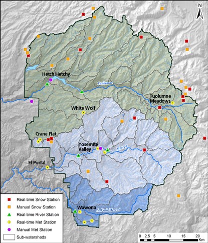
Yosemite National Park contains 21 meteorological stations, 18 of which are automated "real-time" stations, and three that are manually operated. Weather stations measure one or more of the following: air temperature, humidity, wind speed and direction, barometric pressure, precipitation, solar radiation, snow depth, and snow water equivalent. Several stations include parameters important to fire management, including fuel temperature and fuel moisture. Weather stations are managed by the California Department of Water Resources (DWR), the Merced Irrigation District (MID), the Hetch Hetchy Water and Power (HHWP), the National Oceanic and Atmospheric Administration (NOAA), the National Weather Service (NWS), and the National Park Service (NPS). Data from the automated stations is provided by the California Data Exchange Center and the University of Utah's MesoWest portals. Data from the Climate Reference Network site at Crane Flat Lookout is available through NOAA.
Weather and river records constitute the longest continuous environmental records in the park, with more than 100 years of observations at some stations. Why was this information collected originally? To answer water supply, flood, and weather forecasting needs. Over time, data expanded to include fire management and climate change impacts. The longest records come from the cooperative weather station in Yosemite Valley (since 1905), gaging stations at Hetch Hetchy (2011), and the Happy Isles and Pohono Bridge gages on the Merced River (since 1911-1916). Snow courses were added in the 1930s and 1940s, and automated snow-pillows were added to many sites in the 1980s and 1990s. Automated weather stations were installed near the same time.
Yosemite's 21 Meteorological Stations
(shown on map as Met stations)
- South Entrance: 5,120 feet (manual NWS Cooperative station operated by the NPS)
- Yosemite Valley: 4,000 feet (manual NWS Cooperative station operated by the NPS and an automated station operated by MID)
- Hetch Hetchy: 3,920 feet (manual NWS Cooperative station operated by the HHWP)
- Crane Flat Lookout: 5,960 feet (automated station operated by DWR and a second automated station operated by the Climate Reference Network and shared through NOAA)
- Crane Flat Meadow: 6,200 feet (automated station operated by DWR)
- Gin Flat: 7,000 feet (automated station operated by DWR)
- Lower Kibbie Ridge: 6,700 feet (automated station operated by DWR)
- Paradise Meadow: 7,650 feet (automated station operated by DWR)
- White Wolf: 7,900 feet (automated station operated by DWR)
- Slide Mountain: 9,200 feet (automated station operated by DWR)
- Tenaya Lake: 8,150 feet (automated station operated by DWR)
- Tuolumne Meadows: 8,600 feet (automated station operated by DWR
- Gaylor Pit: 9,200 feet (automated station operated by DWR)
- Dana Meadow: 9,800 feet (automated station operated by DWR)
- Tioga Pass: 9,045 feet (automated station operated by DWR)
- Merced Lake: 7,300 feet (automated station operated by DWR)
- Happy Isles: 4,016 feet (automated station operated by the NWS)
- Wawona: 4,960 feet (automated station operated by NPS)
- Mariposa Grove: 6,400 feet (automated station operated by DWR)
Meteorological Stations Outside of Yosemite
(shown on map as Met stations)
- El Portal: 2,100 feet (automated station operated by NPS)
- Mather: 4,800 feet (manual NWS Cooperative station operated by HHWP)
- Horse Meadow: 8,400 feet (automated station operated by DWR)
- Ellery Lake: 9,645 feet (automated station operated by DWR)
- Gem Pass: 10,750 feet (automated station operated by DWR)
- Virginia Lakes Ridge: 9,300 feet (automated station operated by the National Resources Conservation Service)
-
Snow Courses: Fifteen snow courses in the park are measured monthly from February through May to estimate water stored in the snowpack. (Additional snow courses and weather stations outside of the park boundaries are included on the park's hydrology map to help provide a more complete picture of conditions, particularly of snowpack.)
Yosemite's 15 Snow Course Locations
- Gin Flat: 7,000 feet (includes snowpillow)
- Lower Kibbie Ridge: 6,700 feet (includes snowpillow)
- Paradise Meadow: 7,650 feet (includes snowpillow)
- Tenaya Lake: 8,150 feet (includes snowpillow)
- Tuolumne Meadows: 8,600 feet (includes snowpillow)
- Dana Meadow: 9,800 feet (includes snowpillow)
- Snow Flat: 8,700 feet
- Rafferty Creek: 9,400 feet
- Peregoy Meadow: 7,000 feet
- Beehive Meadow: 6,500 feet
- Lake Vernon: 6,700 feet
- Wilma Lake: 8,000 feet
- New Grace Meadow: 8,900 feet
- Spotted Fawn: 7,800 feet
- Sachse Spring: 7,900 feet
Snow Course Locations Outside Yosemite
- Upper Kibbie Ridge: 6,700 feet
- Bond Pass: 9,300 feet
- Sawmill Ridge: 8,750 feet
- Virginia Lakes: 9,400 feet
- Virginia Lakes Ridge: 9,300 feet (includes snowpillow)
- Saddlebag Lake: 9,750 feet
- Ellery Lake: 9,645 feet
- Tioga Pass: 9,800 feet
- Gem Pass: 10,750 feet (includes snowpillow)
- Cora Lakes: 8,400 feet
River Gages: In addition to weather stations and snow courses, there are seven automated river gages: five of those are operated by the U.S. Geological Survey (USGS), one by Hetch Hetchy Water and Power (HHWP), and one by Merced Irrigation District (MID). River gages primarily measure water stage or depth, which is translated into flow (volume per unit time) via a stage-discharge table developed and maintained through regular manual measurements of flow. Some gages report water temperature and turbidity.
Yosemite's Seven River Gage Locations
- Falls Creek (operated by HHWP)
- Tuolumne River at Grand Canyon of the Tuolumne above Hetch Hetchy (operated by USGS)
- Tuolumne River near Hetch Hetchy (operated by USGS)
- Eleanor Creek (operated by USGS)
- Merced River at Happy Isles Bridge (operated by USGS)
- Merced River at Pohono Bridge (operated by USGS)
- South Fork Merced at Wawona (operated by MID)