
NPS/Jim Peaco Stroll Through Norris Geyser BasinNorris Geyser Basin is the hottest, oldest, and most dynamic of Yellowstone's thermal areas. The highest temperature yet recorded in any geothermal area in Yellowstone was measured in a scientific drill hole at Norris: 459°F (237°C) just 1,087 feet (326 meters) below the surface! There are very few thermal features at Norris under the boiling point (199°F at this elevation). Norris shows evidence of having had thermal features for at least 115,000 years. The features in the basin change daily, with frequent disturbances from seismic activity and water fluctuations. The vast majority of the waters at Norris are acidic, including acid geysers which are very rare. Steamboat Geyser, the tallest geyser in the world at 300–400 feet (91–122 m) and Echinus Geyser (pH 3.5 or so) are the most popular features. The basin consists of two areas: Porcelain Basin and the Back Basin. Porcelain Basin is barren of trees and provides a sensory experience in sound, color, and smell; a 3/4-mile (1.2-km) bare ground and boardwalk trail accesses this area. Back Basin is more heavily wooded with features scattered throughout the area. A 1.5-mile (2.4-km) trail of boardwalks and bare ground encircles this part of the basin. The area was named after Philetus W. Norris, the second superintendent of Yellowstone, who provided the first detailed information about the thermal features. Parking Lot Norris Geyser Basin Parking Lot
This parking lot serves the Norris Geyser Basin (where Steamboat Geyser is located) and the Norris Geyser Basin Museum. The parking lot regularly fills during summer and you may see rangers directing vehicles at the intersection or parking lot. Follow their instructions, use overflow parking if necessary, and if overflow parking is full, be prepared to visit the site at a different time. (The trail from overflow parking to the site is approximately a half-mile.)
Norris Geyser Basin Parking No fee for Norris Geyser Basin Parking Cost: $0.00 Amenities
Image Gallery
Enhance Your Geology KnowledgeNorris Geyser Basin sits on the intersection of major faults. The Norris–Mammoth Corridor is a fault that runs from Norris north through Mammoth to the Gardiner, Montana, area. The Hebgen Lake fault runs from northwest of West Yellowstone, Montana, to Norris Geyser Basin. This fault experienced an earthquake in 1959 that measured 7.4 on the Richter scale (sources vary on exact magnitude between 7.1 and 7.8). These two faults intersect with a ring fracture that resulted from the Yellowstone Caldera of 600,000 years ago. These faults are the primary reason that Norris Geyser Basin is so hot and dynamic. The Ragged Hills around parts of Back Basin and are thermally altered glacial moraines. As glaciers receded, the underlying thermal features began to express themselves once again, melting remnants of the ice and causing masses of debris to be dumped. These debris piles were then altered by steam and hot water flowing through them. Gibbon Falls lies on the caldera boundary as does Virginia Cascades. 
NPS/Jim Peaco Listen to the Hissing of Roaring MountainLocated just north of Norris on the Norris–Mammoth section of the Grand Loop Road, Roaring Mountain is a large, acidic thermal area that contains many fumaroles. In the late 1800s and early 1900s, the number, size, and power of the fumaroles was much greater than today. 
NPS/Jim Peaco Fish the Gibbon RiverThe Gibbon River flows from Wolf Lake through the Norris area and meets the Firehole River at Madison Junction to form the Madison River. Both cold and hot springs are responsible for the majority of the Gibbon River's flow. Brook trout, brown trout, grayling, and rainbow trout live in the Gibbon River. The Gibbon River is fly-fishing only below Gibbon Falls. 
NPS/Diane Renkin Drive by Scenic Virginia CascadesA three-mile (4.8-km) section of the old road takes visitors past 60-foot (18.3-m) high Virginia Cascades. This cascading waterfall is formed by the very small (at that point) Gibbon River. The drive may be open to cross-country skiing in the winter. 
NPS/Jim Peaco Observe Forest EcologyThis is a 22-mile (35-km) swath of lodgepole pine blown down by wind-shear action in 1984. It burned during the North Fork fire in 1988. This is the site where a news anchor said, "Tonight, this is all that's left of Yellowstone." An exhibit tells the story. 
NPS/Diane Renkin Tour the Norris Geyser Basin MuseumThe Norris Geyser Basin Museum is one of the park's original trailside museums built in 1929–30. The museum is a National Historic Landmark. Its distinctive stone-and-log architecture became a prototype for park buildings throughout the country known as "parkitecture" (Fishing Bridge Museum and Madison Museum date from the same time period and are of the same style). Exhibits on geothermal geology, hydrothermal features, and life in thermal areas were installed in in the 1960s and in 1995. The building consists of two wings separated by an open-air breezeway. An information desk is staffed by National Park Service interpreters. An facility of matching architectural style houses a bookstore. Visit Gibbon FallsThis 84-foot (26-m) waterfall tumbles over remnants of the Yellowstone Caldera rim. The rock wall on the opposite side of the road from the waterfall is the inner rim of the caldera. A decent sized parking area and a long viewing walkway make this stunning waterfall an easy addition for anyone traveling through the area. 
NPS/Jim Peaco Talk to a Retired RangerThe Museum of the National Park Ranger is housed in the historic Norris Soldier Station, located at the entrance to Norris Campground. The Norris Soldier Station was an outlying station for soldiers to patrol and watch over Norris Geyser Basin. It was among the longest occupied stations in the park.
Exhibits depict the development of the park ranger profession from its roots in the military traditions through early rangers and to the present array of National Park Service staff. A small auditorium shows different videos on Norris-related topics. 
NPS/Dave Krueger Explore a Different Thermal AreaArtists Paintpots, Beryl Spring, and Monument Geyser Basin are all areas where you can experience hydrothermal activity. Beryl Spring is found right at a pullout along the Gibbon River, making it very accessible. Artists Paintpots is a small but lovely thermal area just south of Norris Junction. A one-mile (1.6-km) lollipop loop trail takes you to colorful hot springs, two large mudpots, and through a section of forest burned in 1988. Monument Geyser Basin is at the top of a ridge, making it a bit more strenuous to reach. However, the relative solitude and unique hydrothermal features make the trek worthwhile. Stay HereThere is one campground located in this region. Norris Campground is a reservable campground run by the National Park Service. It is located in a forested area near a gently flowing river. A bare ground trail leads you through the woods to Norris Geyser Basin. Norris Campground is closed to the public for the 2023 season. Day use at Norris has risen substantially over the past decade requiring staff to focus largely on day-use issues such as increasing parking congestion, the need for bathroom cleaning, and public safety. Due to Norris’ remote location, the park does not have the staffing required to effectively respond to emergency incidents occurring overnight (law enforcement, emergency medical services etc.). 
Camp in a Campground
Plan a night in one of twelve park campgrounds. Norris Area Frequently Asked QuestionsSteamboat's major eruptions—more than 300 feet (91 m) high—are unpredictable and often many years apart. That said, Steamboat has be very active since spring 2018. Check the Steamboat Geyser page to find out when Steamboat's most recent major eruption occurred. Its frequent "minor phase" eruptions eject water 10–40 feet (3–12 m) high.
Once very predictable, Echinus's eruptions are now months to years apart, but could become frequent again. The colors here, like in other hydrothermal areas, are due to combinations of minerals and life forms that thrive in extreme conditions. At Norris, silica or clay minerals saturate some acidic waters, making them appear milky. Iron oxides, arsenic, and cyanobacteria create the red-orange colors. Cyanidium glows bright green. Mats of Zygogonium are dark purple to black on the surface where they are exposed to the sun, bright green beneath. Sulfur creates a pale yellow hue.
Norris is not in the Yellowstone Caldera, but it is close to the caldera rim, with its associated ring fractures and faults. The northern edge of the first caldera lies near the southern base of Mount Holmes, which is north of Norris. The Yellowstone Caldera's rim is south and east of Norris.
Periodically, Norris Geyser Basin undergoes a large-scale basin-wide thermal disturbance lasting a few days to a few weeks. Water levels fluctuate, temperatures and pH change, color changes, and eruptive patterns change throughout the basin. No one is sure what causes a thermal disturbance. It might be caused by a massive fluctuation in the underground reservoirs providing water to the basin's features. In the fall, this may happen when surface water levels decrease, causing a decrease in pressure in deeper, underground thermal water. This may allow the deeper thermal waters to mix and flow to the ground surface.
The area is named for Philetus W. Norris, the second superintendent of Yellowstone, who provided early detailed information about the hydrothermal features. Two historic buildings remain in this area: The Norris Geyser Basin Museum and the Museum of the National Park Ranger, which is located in the Norris Soldier Station, one of the only remaining soldier stations in the park.
Visitors during the late 1800s and early 1900s would recount "roars" from Roaring Mountain, a large, acidic hydrothermal area (solfatara) with many fumaroles. The number, size, and power of the fumaroles were much greater than today. The fumaroles are most easily seen in the cooler, low-light conditions of morning and evening.
This one-way drive east of Norris follows the Gibbon River upstream, alongside outcrops of volcanic rock (Lava Creek Tuff). Here, you are close to the Yellowstone Caldera's rim. Virginia Cascade is formed by the Gibbon River as it crosses the tuff.
Yes, at Artists Paintpots, which is located 3.8 miles (6.1 km) south of Norris Junction. The trail to the mudpots is steep, and one mile (1.6 km) round-trip.
Black and grizzly bears are sometimes seen. Grizzlies feed on carcasses of elk and bison that died in the hydrothermal areas during the winter. Norris is one of the few areas in the park where sagebrush lizards live. They can survive here due to the warmth of hydrothermal activity. Listen for chorus frogs in spring. Killdeer are found in the basin year-round, taking advantage of the brine flies and other insects that live in the warm waters. 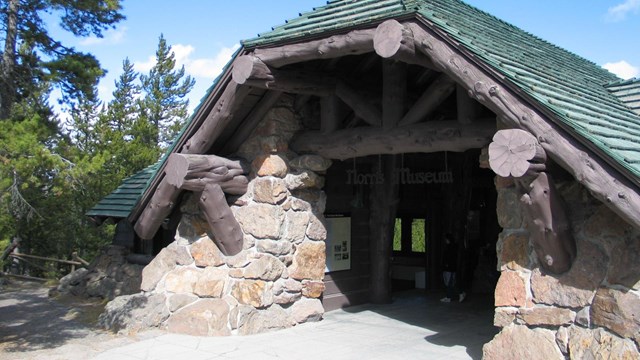
Norris Geyser Basin Museum
Start here to begin your exploration of the Norris Geyser Basin. 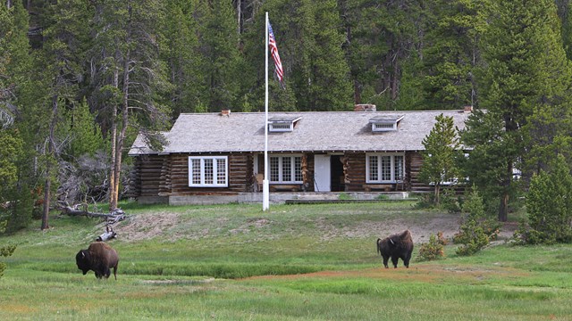
Museum of the National Park Ranger
Discover the history of the national park ranger. 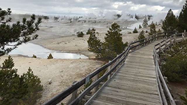
Accessibility in the Norris Area
Learn about accessibility options in the Norris Geyser Basin area. 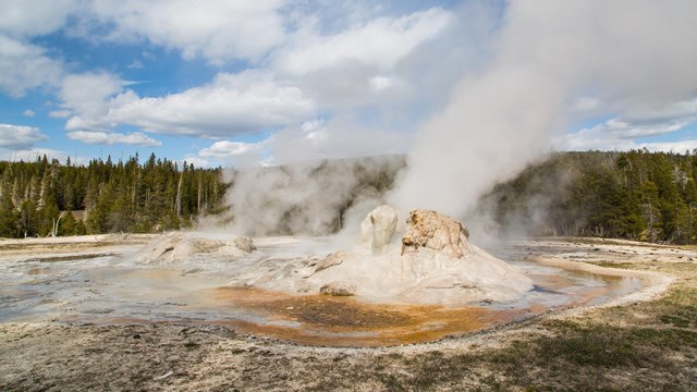
Places To Go
Learn more about the amazing variety of destinations in Yellowstone. 
Plan Your Visit
Yellowstone is seasonal. Plan your visit by learning about current conditions, seasons, road conditions, services, activities, and more. |
Last updated: June 30, 2023