|
NPS
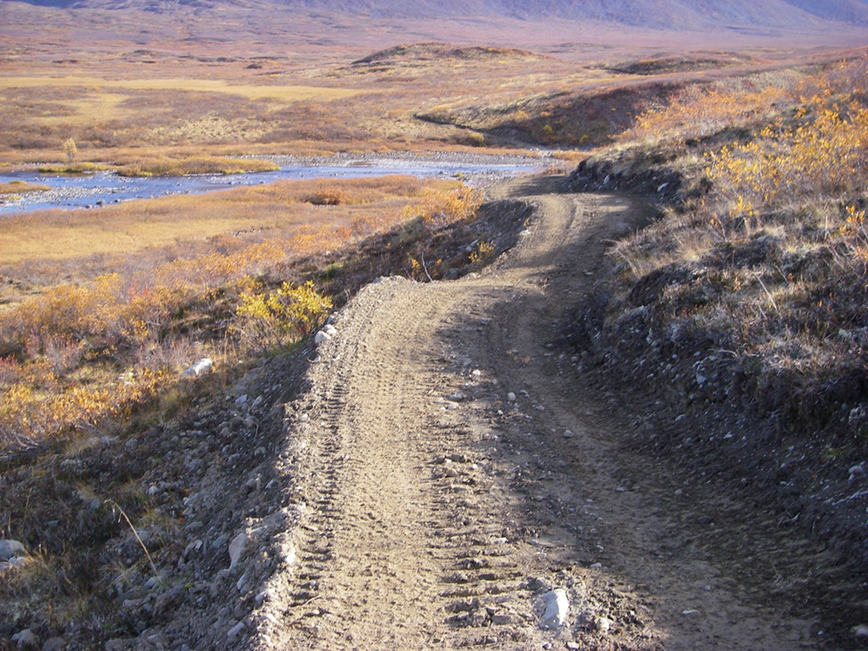
Copper Center, AK –In December 2011, the National Park Service (NPS) signed a Record of Decision for the Nabesna Off-Road Vehicle Management Plan and Final Environmental Impact Statement.The Record of Decision followed a four-year planning process.Included in the Record of Decision was the NPS intent to improve several area trails that originate off the Nabesna road and provide important access for subsistence and recreational activities and provide access to private lands in Wrangell St. Elias National Park and Preserve.These trails pre-date the establishment of the park and have long been used to access sport and subsistence hunting opportunities.With increased use and the advent of 3 and 4-wheelers, motorized use of the trails resulted in impacts to soils, vegetation, and wetlands, making the trails very difficult to negotiate. Proposed trail improvements will come through a variety of methods.These include re-routing the existing trail to a location with better soils, trail hardening through the use of geotextiles and gravel, and trail hardening utilizing porous pavement panels such as Geoblock.The following specific improvements will occur thissummer and fall in Wrangell St. Elias National Park and Preserve: Caribou Creek trail: The trailheadis at mile 19.2 on the Nabesna road.The trail is approximately 4 miles long and accesses a public use cabin.The center portion of the trail traverses a wet meadow and is in poor condition.There are deep ruts and mud holes forming, and trail braiding is starting to occur.The trail is currently closed to recreational ORV use, but still open for subsistence ORV use.The intent is to fix the degraded portion of the trail using a geotextile overlain with gravel.The work will be done utilizing the park's trail crew.Expect to see work starting sometime between June 15 and July 15 and lasting 2 – 3 weeks.The trail will not be closed to subsistence ORV users during improvement activities.This work will improve the trail to a maintainable condition for the first two miles.This year's trail improvements should allow the trail to open again for recreational ORV use in 2013. Soda Lake trail: This trail, formerly known as the Big Grayling or Soda Creek trail, is currently accessed from the Lost Creek trail at the 2-mile mark.It is approximately 2.5 miles from that point to Big Grayling Lake and 10 miles to Soda Creek mineral spring.The middle section of the trail has become degraded, with deep ruts and mud bogs.The Soda Lake trail also accesses and crosses private inholdings.The planned "fix" for this trail is a constructed re-route that will depart the Lost Creek trail at about mile 3.5, traverse higher groundand tie into the upper Platinum Creek, then route back to the original trail.The re-route will by-pass all degraded sections of the trail and the private land inholdings.After completion of the re-route, the old trail will be closed to all motorized use, except those accessing private lands. The Soda Lake trail is currently closed to recreational ORV use, but still open for subsistence ORV use.The re-route will be constructed utilizing heavy equipment, using a full bench construction style that incorporates sustainable trail design concepts.The photos below are an example of full-bench construction on the Seven-mile trail north of the Denali Highway.Photo 1 was taken during construction;Photo 2 was takentwo years after construction.Theresult is a sustainable 4ft – 5fttrail tread with vegetated cut and fill slopes.The Soda Lake re-route construction will be done by Trails Unlimited Enterprise, a U.S. Forest Service trail team that contracts out for trail construction and providestraining in mechanized trail construction.If you are using the Lost Creek trail this year, expect to encounter a work camp at about mile 3.5 .We expect to put the camp in around mid-June withthe re-route construction beginning mid-July and continuing through mid-September.The Lost Creek trail and the existing Soda Lake trail willbe open to subsistence ORV use during trail construction.This year's trail improvements should allow the Soda Lake trail (including the re-route) to open again for recreational ORV use in 2013. Copper Lake trail: Access to the Copper Lake trail is at mile 12.2 of the Nabesna Road.Trail length is approximately 19.4 miles to the wilderness boundary just south of Copper Lake.The trail, which runsthrough wetlands, has many degraded spots, with mud holes, deep ruts, and numerous braided areas.The plan is to improve the first portion of the trail to the Tanada Creek crossing.Improvements will primarily consist of placement of geotextile with a gravel overlay in the existing entrenched trail.The Tanada Creek crossing will have a fiberglass bridge installed.Trail work will be done by the park's trail crew and should get started around July 1.Work may still be on-going during hunting season; however, the trail will be open to subsistence ORV users. Skookum trail: Access to this hiking trail is at mile 36.9 of the Nabesna Road.Trail maintenance activitiesinclude brush clearing and improving water drainage off the trail. Volunteers needed! There will be plenty of volunteer opportunities associated with the scheduled trail improvements this summer.Volunteers will be needed to help clear brush, install geotextile or Geoblock, spread gravel, and other trail improvement activities.Volunteers will need to provide transportation to the work site.If you are interested in volunteering, please contact the Angela Kearns / Slana Ranger Station at822-7401, The primary project goal is to provide a reduced fuel buffer zone on NPS land surrounding the Wrangell St Elias (WRST) headquarters.The project includes the parking area, administrative, visitor center, and seasonal housing structures.The fuel buffer will provide for public and firefighter safety in the event of a wildland fire. The primary project goal is to provide a reduced fuel buffer zone on NPS land surrounding the Wrangell St Elias (WRST) headquarters.The project includes the parking area, administrative, visitor center, and seasonal housing structures.The fuel buffer will provide for public and firefighter safety in the event of a wildland fire. For additional information please call Wrangell-St. Elias Public Affairs at (907)822-7223. |
Last updated: April 14, 2015