|
NPS Photo
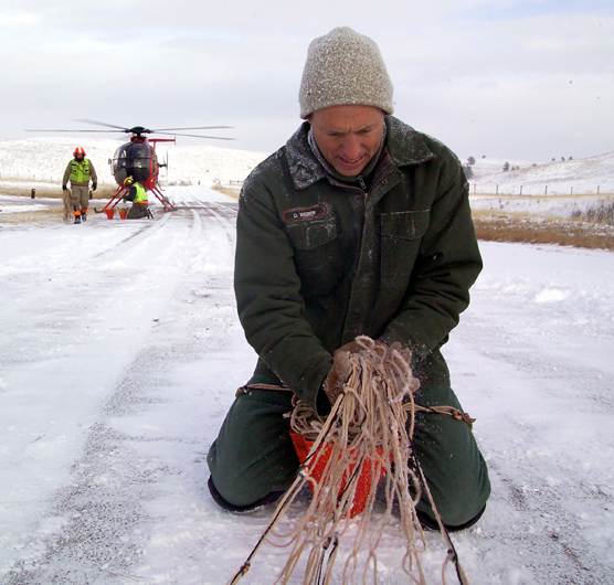
Contact: Tom Farrell, 605-745-4600 WIND CAVE NATIONAL PARK, S.D. – Forty-five GPS (Global Positioning System) radio collars were recently placed on elk in Wind Cave National Park as part of the fourth year of an on-going study to learn about elk movement patterns in the Southern Black Hills. Results from this study are providing the park with information for an Environmental Impact Statement and elk management plan being developed in conjunction with the South Dakota Game, Fish and Parks. This study, conducted in partnership with U.S. Geological Survey, called for the attachment of GPS collars to 22 cow elk and 23 yearling bull elk. These collars record the location of the elk every seven hours. On a rotating basis, several elk each day will have their locations recorded every 15 minutes. The study’s primary investigator, Dr. Glen Sargeant, is a Research Wildlife Biologist for the U.S. Geological Survey from the Northern Prairie Wildlife Research Center in Jamestown, North Dakota. The Geological Survey provides scientific expertise for other Department of Interior agencies such as the National Park Service. “We’ve used data collected during 2005 and 2006 to generate preliminary estimates of pregnancy and survival rates, investigate the distribution of elk within the park, and to delineate the area elk use when they are outside the park,” said Dr. Sargeant. “Additional data collected during 2007-2009 will be used to improve the precision of these preliminary estimates and will permit more detailed analyses.” Capture operations, delayed Monday, January 28, due to high winds, began in earnest on Tuesday, January 29, and finished Wednesday afternoon. The helicopter and animal handling crew were from Leading Edge Aviation out of Clarkston, Washington. The GPS collars attached as part of this study will remain on until December 2009, when they will be remotely released to allow the information collected to be downloaded. |
Last updated: April 10, 2015