Plan Your Visit


The Timucuan Preserve is a 46,000-acre area with individual park sites to visit. Each park site is unique for an aspect of natural or cultural history. There are many ways to access areas within the Preserve, so planning your visit with the directions and materials on these pages will start you on a path that leads to enjoyable and educational experiences.

Click here for information about the park's Passport to Your National Parks stamps.

Your Guide to a Day in the Park

Whether you’re interested in learning about history or the environment, going on a hike, a bike ride or a kayak trip, exploring this area’s natural beauty, the Timucuan Preserve provides a day full of activity. This guide will lead you to several sites to visit and things to do for people with a variety of interests. These stops and activities are catered to those who have an entire day to explore the Preserve.

Activities within the Preserve are free with the exception of the entrance fee for
Little Talbot Island State Park and any equipment rentals from concessionaires.

Note: There is no food available at any of the park sites. Picnicking is permitted. Picnic facilities are available at Fort Caroline, Kingsley Plantation, Cedar Point and the Ribault Club. Dogs are permitted in outdoor areas and must be on a 6-foot leash.

Stop 1
Fort Caroline National Memorial

Time: About 1.5 to 2 hours.
  • Visitor Center
Inside the Preserve Visitor Center are exhibits about the natural history and environment, European exploration and settlement, and the Timucua Indians (including the only owl totem found east of the Mississippi River). The visitor center also houses a small bookstore. Remember to pick up a map of the Preserve in the Visitor Center.
  • Timucuan Hut and Shell Mound
This exhibit can be found along the walk to the fort exhibit.
  • The Fort Exhibit
The fort was built in 1964 and based on historic drawings of the French fort. It is a one-third scale replica.
  • For Kids – Optional Extension
Ask the ranger at the desk in the visitor center how you can become a Junior Ranger for the Timucuan Preserve.
  • Hiking – Optional Extension
Walk the Hammock Trail Loop (1 mile). The Hammock Trail Loop is a circular trail that explores several different Florida ecosystems, with many explanatory signposts along the way. This is the first of five trail systems included in this guide. Take a moment now and read through the rest of this booklet to decide which trails you might want to hike. Look for “Hiking –Optional Extension” designations. Approximate trail lengths are given for each trail.
  • Hiking – Optional Extension
Spanish Pond – Visitors can travel the boardwalk trail, see the pond and read exhibits. Spanish Pond is located directly across from Fort Caroline National Memorial. Length of boardwalk round-trip is 3/4 mile. (Note: this trail is not a loop. You must backtrack to return to your car.)
 
a tiny image of the fort Caroline map, full audio description of the large map is available in the Accessibility section of the website
Pick up a map before you hike.

NPS Image

Stop 2
Theodore Roosevelt Area (Hiking – Optional Extension)

Time: About one hour. Park operating hours 9:00 am to sunset daily. Hiking trails and signs only – no Visitor Center.
Restrooms available.
The Theodore Roosevelt Area offers visitors five different Florida ecosystems in one hike. Visitors can experience miles of thickly wooded peaceful nature trails, vast grassland that supports both water and land animals, ancient piles of discarded oyster shells which yield clues about an extinct culture, and the legacy of preservation bequeathed to all by this
property's last private owner, Willie Browne.
The trailhead is located off Mount Pleasant Road. Pick up a trail map from the bulletin board before heading out.
  • Birding Platform
There is a bird observation platform that looks out over Round Marsh located at the end of the Willie Browne Trail. From the parking lot to the platform and back is about 1.5 miles.
(Note: this trail is not a loop. You must backtrack to return to your car.)
 

Crossing the St. Johns River

The remaining tour stops are north of the St. Johns River. The St. Johns River, originally called the River of May by French explorer Jean Ribault, has been crucial to the peoples inhabiting this area for thousands of years. It is also one of the rivers in the world that flows north.
There are two ways to cross the river. One is to cross via the St. Johns River ferry. This ferry carries vehicles and pedestrians across the river between Mayport and Fort George Island. The ferry runs daily every thirty minutes. There is a fee. Turn right onto A1A.
The river can also be crossed via the Napoleon Bonaparte Broward Bridge,(I-295 North), then north (right) on Heckscher Drive.
It takes approximately 45 minutes to reach the next stop, the Ribault Club on Fort George Island.

Stop 3
The Ribault Club
Fort George Island Visitor Center

Time: 45 minutes to one hour. Park operating hours 9:00 am to 5:00 pm, Wednesday through Sunday.
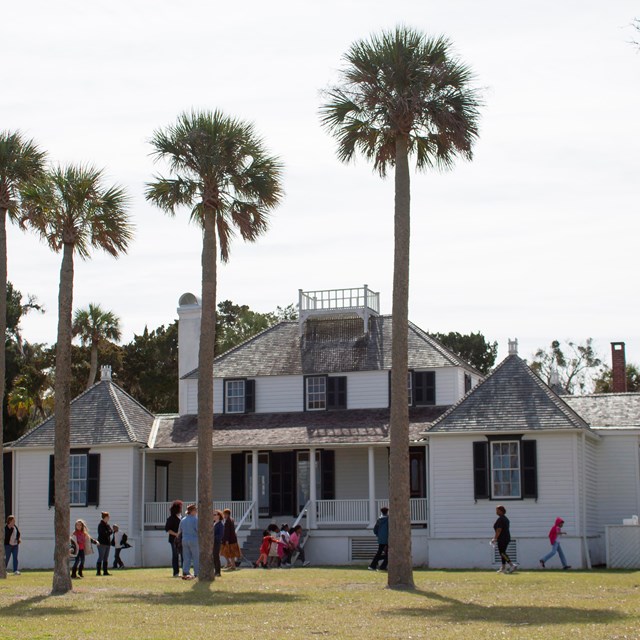
The Ribault Club houses the Fort George Island Visitor Center which is open Wednesday through Sunday and is part of the Talbot Islands State Parks. The building is a recently-restored 1920s golf and country club. Inside are interactive exhibits about Fort George Island’s natural and cultural history. Spend some time looking at the exhibits inside. Then walk outside and enjoy the peace and quiet of the island. Sit on a rocking chair or a bench and relax. This building is available for weddings and other events, but the exhibits remain open during normal park hours.

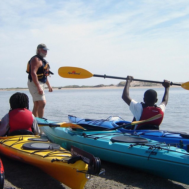
There is a primitive boat ramp at the Ribault Club from which you can launch small boats, canoes and kayaks.
  • Hiking – Optional Extension
A 3.5-mile nature trail loop on the island travels through manmade and natural landscapes. This is also a bike trail. Begins at the Ribault Club.
  • Segways – Optional Extension
See Fort George Island from a Segway. Call Kayak Amelia to reserve a place
for their unique tour of island historic and natural attractions. Call for information at 904-251-0016. There is a
fee.
  • Virtual Tour – Optional Extension
Rainy day? Want to do some driving? Check out the Virtual Ranger Tour of the Saturiwa Trail (the road that circles Fort George Island). Insert the tour CD into your car’s radio and learn about thisisland’s history. The CD is available at Little Talbot Island State Park, Kelly Seahorse Ranch, and the Ribault Club. The tour lasts about 1 hour and begins and ends at the Ribault Club. Text of this tour is also available.
 
Plantation house at Kingsley Plantation

Stop 4
Kingsley Plantation

Kingsley Plantation is a historic Sea Island cotton plantation. Visitors explore thisplace where enslaved men, women and children lived and worked more than 150 years ago. The site includes the oldest standing plantation house in Florida and a unique semicircular row of tabby slave cabins. The plantation grounds are set up to be self-guiding. Interpretive exhibits can be viewed throughout the grounds, at the slave quarters, inside the barn, and in the north room of the Kitchen House. Make sure to leave plenty of time for exploring the grounds and viewing the exhibits.
Other available features include an interpretive garden, a self-guided Grounds Tour brochure, and a bookstore and visitor contact station. In the bookstore, ask to see and touch a sample of Sea Island cotton.
The main plantation house is currently closed and undergoing structural work.
  • For Kids – Optional Extension
Ask a ranger how you can become a Junior Ranger. The Timucuan Preserve Junior Ranger
Program includes activities like the cotton talk and is avaliable for all ages.
  • Audio Tour -Optional Extension
A free audio tour entiled The Lion's Story Teller is avaliable in the visitor center. A photo id is needed to check out the device which explores the lives of the plantation residents.

Kayaking in the Timucuan Preserve

  • Optional Extension
Kayaking is a great way to experience the Timucuan Preserve. You can see plants and animals in the salt marshes and waterways that cannot be seen from land. There are many kayak routes in the Preserve north of the St. Johns River. Kayaking in this area requires a map and a knowledge of local tides. Tide forecasts may be found in local newspapers, online or on NOAA weather radio. Kayakers should bring drinking water, sunglasses, insect repellent, and a survival and first aid kit.
Kayak Amelia is the kayak concessioner for the state parks within the Preserve. They provide rental kayaks and guided tours. Kayak Amelia is located near the bridge to Big Talbot Island on A1A. Launch sites include Cedar Point, the Ribault Club, Huguenot Park, Alamacani Boat Ramp, and Sisters Creek Park Boat Ramp.

 
beach with rocks and drift wood

Stop 5
Talbot Islands State Parks

Time: Open. Park operating hours 8:00 am to sundown daily, including holidays.
There are seven state parks that together are referred to as the Talbot Islands State Parks. Many of these parks are within the Timucuan Preserve. Included here are three of these park sites. Depending on how much time you have, you can visit one or all three.
  • Big Talbot Island State Park
This park primarily a natural preserve, a premier location for nature study, bird-watching, and photography. The park’s famous Black Rock beach is covered with the skeletons of live oak and cedar trees that once grew near the ocean. Visitors can picnic at the Bluffs access overlooking the water, then take a stroll down the Shoreline Trail to walk the beach or sunbathe. There is a fee. The park is located on A1A just south of Amelia Island.
  • Little Talbot Island State Park
This park is one of the few remaining undeveloped barrier islands in Northeast Florida. Maritime forests, desert-like dunes, and undisturbed salt marshes on the western side of the island allow hours of nature study and relaxation. It is a good spot for wildlife and bird watching. Other popular activities are hiking the trail loop, fishing, swimming, canoeing, and surfing. The park has camping facilities. Beachside picnic pavilions are available for visitors to the park. There is an entrance fee. The park is located on the east side of A1A just north of Fort George Island.
  • Pumpkin Hill Creek Preserve State Park
This park protects one of the largest contiguous areas of coastal uplands remaining in Duval County. protect the Equestrians, hikers, and off-road bicyclists can explore five miles of multi-use trails. The park has a canoe/kayak launch accessible by a 500 foot portage to the marshes. To reach Pumpkin Hill, turn north on New Berlin Road off Heckscher Drive, then east on Cedar Point Drive. Turn north on Pumpkin Hill Road. Trailhead parking is approximately one mile on the left. There is no fee.
  • Programs – Optional Extension
Visit the state parks’ website or call for the schedule of ranger programs.
 
slave cabins
Visitors explore the tabby slave cabins of Kingsley Plantation.

NPS Photo

Last updated: December 22, 2022

Park footer

Contact Info

Mailing Address:

12713 Fort Caroline Road
Jacksonville, FL 32225

Phone:

904-641-7155

Contact Us