


Diving in Cape Hatteras National Seashore
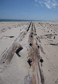 Shipwreck on the shore of Cape Hatteras National Seashore
Hatteras is part of the narrow island network that along with Cape Lookout comprises the Outer Banks. These barrier islands feel entirely different from Cape Cod, where the expanses of sand are backed by high bluffs and glacially scoured terrain. Here, without the topographic relief, sand dunes dominate a flat landscape resembling Fire Island, New York, or Assateague, Virginia. Cape Hatteras National Seashore extends north to south across Bodie, Hatteras, and Ocracoke islands. State Highway 12 straddles the narrow strip and, along with a system of ferries, provides a continuous route for the automobile traveler back to the mainland or on to Cape Lookout, where there are no established roads. The offshore shallows provide an endless supply of sand that is deposited by wind and surf on the barrier islands. Sea oats and other plants try to hold their own under a constant assault of wind and salt water. Some hardy live oak and maple trees manage to eke out an existence in stands between the roiling ocean to the east and the quieter waters of Pamlico Sound to the west. Many ducks, swans, and shorebirds thrive in the area; some even use historic structures such as the Bodie Lighthouse for landing markers.
Speaking of landing markers, it's well worth your time to visit the Wright Brothers National Memorial in Kill Devil Hills, north of the park's northern entrance. Here, in 1903, Orville and Wilbur Wright put together a flimsy wood and fabric structure, added a tiny engine they designed themselves, and took off over the sand dunes near Kitty Hawk on the first manned, powered flight in history.
OUTER BANKS HISTORY
As beautiful as the area may be, no place more deserves the title "Graveyard of the Atlantic" than the Outer Banks, where more than 600 ships have been brought to grief. A glance at a map of the Atlantic seaboard leaves one with the impression that the Outer Banks and its associated shoals are a foot stuck out in a crowded hallway to trip up passing traffic. For sailing ships and early steamers, the advantage of riding the gulf stream up from the south and the Labrador Current down from the north compensated for the risk involved in coming too close to shore. Gulf and Labrador currents converge at the Outer Banks, where they conspire with the high waves of winter nor'easters and tropical hurricanes to redraw submerged shoals as well as the islands themselves.
If Nature made shipping around the Outer Banks dangerous, World War II brought a new level of destruction to the Outer Banks. In January 1942, Germany initiated "Operation Drum Roll"-a concerted attack on Allied merchant shipping along the Atlantic seaboard by U-boats, which continued until June 1942. German submarine skippers were quick to learn that the most vulnerable point on the coast was the Outer Banks, and "Torpedo Junction," as it became known, was the scene of over 80 sinkings.
With time, a ship disaster often becomes a diver's delight. Most of the shipwrecks visited by divers in this area are several miles offshore and beyond the boundary of the park. Managers from both parks, however, have been working with the state of North Carolina to integrate efforts at stewardship of historic shipwrecks and other maritime history in the area.
Some of the wrecks are now part of the dynamic sand dunes that comprise these barrier island parks. For divers truly interested in understanding shipwrecks rather than collecting portholes and other trophies, the ship remains in the sands present an excellent opportunity to learn about marine architecture and how vessels tend to break up. Cape Hatteras National Seashore rangers have gone to great lengths to protect and interpret these sites in the most instructive manner.
Walk about the remains of the four-masted schooner G.A. Kohler located at Ramp #27 four miles from Salvo. Then check out the diplay of the Laura Barnes which has been relocated to a mile south of where it originally wrecked to Coquina Beach across from the Bodie Island Lighthouse. (If you’d like to imagine seeing them underwater, squint your eyes and move your arms in a swimming motion.) Seeing these remains above water (and you may or not depending on the most recent movements of the sand) will help you understand more about the wooden ships you encounter when diving the Cape’s wrecks.
Unfortunately, these dune wrecks are at the mercy of shifting sands as is everything else in this dynamic environment. In 1997, sand migrated over portions of sites that had been well exposed in 1994. Check at the visitor center for the latest status of shipwrecks in the dunes.
BASICS
Location: North Carolina barrier islands
Skill level: Intermediate-advanced
Access: Shore
Dive support: Morehead City, Nags Head, Hatteras, Beaufott, NC
Best time of year: Summer
Visibility: Less than 5 feet near shore, better on wrecks outside of park in deep water
Highlights: Wreck remains, some fish
Concerns: Currents in many places, surge when diving off beach
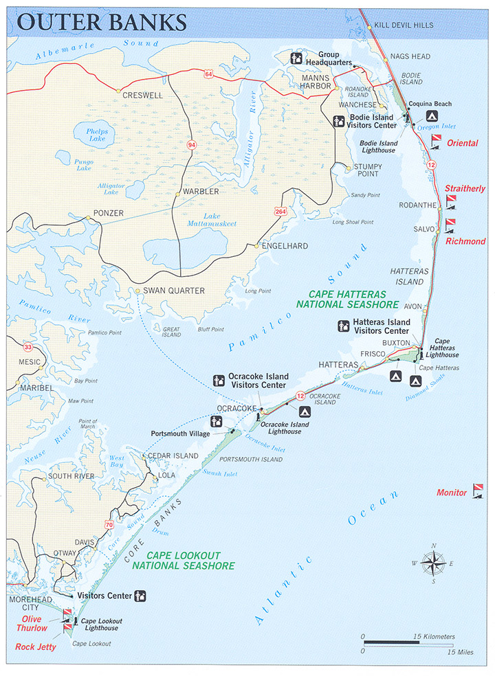
Dive Site Map
Dive Overview
Although the Outer Banks parks have an extensive maritime history and are becoming a mecca for shipwreck divers, it should be noted that few submerged sites are actually under National Park Service jurisdiction, which usually ends in ankle deep water. Even access to the sites through the parks is limited, most of it occurring from private dock areas interspersed throughout the Outer Banks. Exceptions are herein listed but none are great dives worthy of “destination” status. The sites, several miles offshore, however, are most definitely worthy of a visit solely for diving purposes. For information on trips to these sites, it is best to query dive shops along the banks, particularly at Hatteras, Nags Head, and Morehead City. These are open only in the summer, but if you leave a message in the off-season, your call will be returned.
Dive Sites
ORIENTAL
This site is comprised of the engineering spaces, drive train, and part of the hull of a 210-foot, iron-screw steamer. Built in 1861, it was leased by the U.S. Army as a troop transport. It ran aground in 1862 on the outer sandbar three miles south of, Oregon Inlet. To see it, park at the U.S. Fish & Wildlife Visitor Center and walk to the beach. The boiler is visible approximately 200 yards offshore. It lies in 251 feet of water with visibility of 10-15 feet.
RODANTHE
A wreck reputed to be the steamer Straitherly can be found 250 yards off the Hatteras Island fishing pier, 15 miles south of Oregon Inlet, in Rodanthe. The wreckage (approximately 90 feet long) lies in 20-25 feet of water on the edge of the outer bar. There are reportedly half a dozen types of coral on this site, a testimony to its proximity to the Gulf Stream. Current and surge can be significant on this site.
SALVO
About 18 miles south of Oregon Inlet is the wreck the locals refer to as the Richmond. The site is one half mile north of Ramp 23 at Salvo. It can be reached by four-wheel-drive vehicles on the beach except for May through September when they are not permitted. The wreck was 200 feet offshore in the spring of 1997. The wreck is presently easy to find because what appears to be a large iron rod associated with the paddle wheel arrangement extrudes from the water, which is 15-20 feet deep at this point. Some longtime maritime buffs believe this is actually the Civil War steamer Pocohontas. Like the Straitherly the site is buffeted by current and surge.
USS MONITOR
Off Cape Hatteras lies the remains of one of the most famous warships in American naval history, the USS Monitor. It sank and came to rest in approximately 200 feet of water, during an abortive attempt to tow it from Hampton Roads, Virginia, to Beaufort, North Carolina, in December of 1862. Only months earlier it had fought the Confederacy's Virginia {Merrimac} to a standstill at Hampton Roads. The stalemate between the two ironclads meant that the Confederacy would not be able to break the blockade of southern harbors with similar ironclads, resulting in a strategic victory for the Union.
The Monitor now is a National Marine Sanctuary, and diving on the ship may be done only through permit with National Oceanic and Atmospheric Administration (NOAA). There have been a series of dives conducted on the wreck by sport/technical divers staging their operations from Morehead City and Nags Head. It is a spectacular but expert-level dive. Contact NOAA for permission.
.
DIVING RULES AND REGULATIONS
Diver-down flag must be displayed while divers are in the water.
The NPS has no special rules or regulations pertaining to diving at Cape Hatteras or Cape Lookout.
Familiarize yourself with North Carolina state laws regarding taking of game by calling the North Carolina Wildlife Resources Commission 919-482-2915 or asking at local tackle and dive shops.
All antiquities are protected in National Parks, including the shipwrecks in the dunes. North Carolina also has protective legislation covering historic shipwrecks offshore.
Metal detectors are not allowed on any park land.
Last Updated: October 26, 2012


