


Diving in Big Horn Canyon National Recreation Area
 Bighorn Canyon National Recreation Area
Bighorn National Recreation Area embraces a 71-mile-reservior, Bighorn Lake, formed through the impoundment of the Bighorn River by the Yellowtail Dam. The land surrounding Bighorn Canyon, particularly on the eastern side, is surprisingly pastoral and tame-gently rolling hills sprinkled with ranches, farms, and tiny towns. This gentle landscape suddenly gives way to a rugged, precipitous canyon cut by the river: sheer limestone and sandstone formations with twisted strata showing signs of violent upheaval over millions of years.
You can enter the park from either the south or the north, but there is no road connecting the two entrances, so you should decide where in the park you want to spend your time and choose your entrance accordingly. The park is popular with visitors stopping off on their way to and from Yellowstone, but divers favor the northern end. The water is clearer at the northern end because by the time water reaches this area it has lost most of its sediment load. If you do choose the north entrance, take some time to tour the Yellowtail Dam. The National Park Service runs an excellent visitor center here in association with the Bureau of Reclamation.
Basics
Location: Southern Montana on the Wyoming border
Elevation: 3,640 feet
Skill level: Beginner-intermediate
Access: Limited shore, mostly boat
Dive support: Billings, MT; Casper, WY; Sheridan, WY
Best time of year: June-October
Visibility: Highly variable, depending on dive site, depth, and conditions
Highlights: Clear water, glacier geology Concerns: Elevation, diving Big Horn Bend is not recommended
Dive Site Map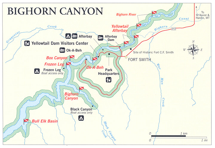
Dive Overview
The best diving is toward the dam at the north end of the lake, and most of it requires a boat. You can launch a boat from ramps at Horseshoe Bend and Barry's landing, which you can reach by paved road from Lovell and Sheridan, Wyoming. At the north end of the lake the Ok-A-Beh boat ramp, located ten miles from Fort Smith Montana, rents boats in the summer. Recreational divers need not register but it is always a good idea to check in with the rangers regarding conditions or special considerations. Diving is an established activity on the lake, and the marinas even have handouts for boaters explaining the red-and-white and alpha diving flags.
Visibility is best from August through October, when siltation has pretty much subsided, although the warmer water then may cause an algae bloom. For the better visibility, dive below the thermocline, and to escape boat traffic stay in the side canyons. Rangers from this park discourage diving at Horseshoe Bend, The Bighorn River brings in a lot of silt just south of here greatly reducing visibility. With heavy boat traffic and current, as well, they feel you could do better diving elsewhere in the lake. This is a recommendation not a prohibition.
Note that lake elevation is 3,640 at normal pool level and driving over Ok-A-Beh requires to going to 4,500 feet. Keep your altitude conversions handy.
Dive Sites
BULL ELK BASIN
Located north of Dryhead Creek, the gradual slope of the canyon wall provides opportunity for shallower dives, but be particularly cautious here to monitor weather conditions because the basin is susceptible to sudden high wind and wave action. Visibility at this part of the lake depends on the amount of algae in the water. In general, it varies from five feet to 20 feet.
BLACK CANYON
One of the more popular diving areas in the park, with lots of fish and good visibility except after rain. It's a good place to do a night dive, but be cautious day or night as this area can have a fair amount of boat traffic.
FROZEN LEG BAY
After a rapid drop-off to about 80 feet, the bay then slopes gradually deeper toward the main canyon. A marina once operated in this area so you may find junk scattered around on the bottom. Divers are invited to remove marina-related junk from the bottom to help the Park Service restore the area to its original condition. This spot is located near reservoir marker #4 on the west side of the lake. At this location you'll find a floating comfort station and docks.
OK-A-BEH
You are not allowed to dive at this marina during the summer, nor do we recommend it at other times of the year. There is a protected beach and swimming area in the marina but divers are not allowed to enter the water through this area. Just out from the boat ramp, before you round the point to the north into the main canyon, is a very nice dive. The bottom is composed of a series of wide ledges that extend down to about 70 feet, before dropping steeply to the canyon floor. The area is scattered with small cave-like alcoves, carved out of the rock by wind before the area was flooded. For a landmark, look for an amphitheater-like hollow carved out of the canyon wall. Visibility in this area is usually 20 to 30 feet, and on our dive we saw numerous large crayfish, almost big enough to be mistaken for lobsters.
BOX CANYON
Located between Ok-A-Beh and the Yellowtail Dam, this can be an interesting intermediate dive. The depth below the dock can be over 100 feet, but you can execute a nice dive by following the 50 to 80-foot-deep ledge along the canyon wall. .
YELLOWTAIL AFTERBAY
This area offers a dive that has no drop-off and at its deepest is approximately 30 feet. The visibility here ranges from between four and 20 feet. It is also usually quite cold, 38-45 degrees, though occasionally up to 60 degrees in midsummer. Divers can visit the historic Crow Canal head-gate, built in 1906. Just downstream from the head-gate on the north side of the bay is a welding truck that has been underwater since the construction of the dam.
RIVER DRIFT-DIVE
This can be an exciting dive and give you an opportunity to see a lot of trout. When the river flows more than 2,000 cubic feet per second or less than about 8,000 c.f.s. you can have a nice drift down the river in depths ranging from five to 25 feet. The visibility will be fair, and the water cold. If the flow is less man 2,000 c.f.s. the river is too shallow in many places to make this dive possible, and when it is more than 8,000 feet it's too dangerous. (Before diving this area, check with authorities about the release rates for the day.)
Be sure that you have a well-marked support boat with you. In addition, if you don't want to scuba dive this, it can make a good snorkel. And be courteous to trout fishermen who are floating the river at the same time.
DIVING RULES AND REGULATIONS
Scuba diving is not permitted within designated swimming, mooring, and docking areas.
No public use is allowed a quarter mile downstream from the Yellowtail Dam.
No diving is allowed within 200 yards of the Afterbay Dam.
Spearfishing in the Montana portion of the park is restricted to non-game fish. In Wyoming game fish may be taken provided the diver is completely submerged and has obtained an underwater fishing license.
Last Updated: October 26, 2012


