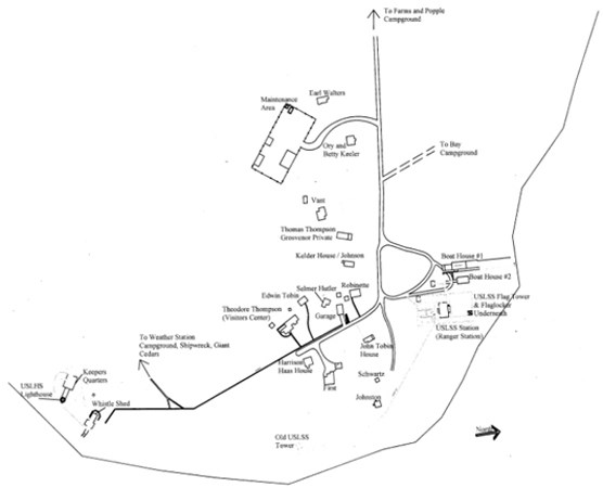
Welcome to South Manitou Island. As you leave the boat and walk down the dock toward the village, the first building you see is the U.S. Life-Saving Service (USLSS) Boathouse at the end of the dock. If you are camping on the island, this is where you will have your orientation. Take a moment to visit the boathouse and see one of the original surfboats that was used by the USLSS here on South Manitou Island. You will see the carriage and rails that were used to launch the boat and some of the other equipment as well. On your left, right next to the main boathouse is another smaller boathouse, which was also used by the USLSS to store their boats and equipment.
South Manitou ISland Life-Saving Station & Ranger Station
Kerry Kelly 2007
To the left of the smaller boathouse is the USLSS/CG Station, which is now used as the NPS Ranger Station on the island. This is a nice spot for a picnic lunch after your boat ride and before heading off to explore the rest of the island. Water and flush toilets are available just behind the boathouses.
South Manitou Island (SMI) was first settled by William Burton and his family, originally from Vermont. They arrived around 1835 and by 1838 there was a house and steamboat landing belonging to Burton where he provided cord wood to fuel the steamers. The dock and early village was located in the middle of the bay.
Graves near Chicago Road dock and ruin of General Store of the origianl SMI Village.
Kerry Kelly 2007
At some point during your visit, you might want to walk down the beach to the site of the old dock and village where Chicago Road comes out to the beach. A few pilings are still visible near the shore. In 1847, the old village had a blacksmith shop, grocery store, and a barn. There was a wooden tamarack railroad track extending inland with branches for hauling cord wood to the dock. About 3-4 miles of track existed. There isn’t much left of the original village, but a few feet down Chicago Road from the beach, you will find the ruin of the village general store and a few graves of early settlers and sailors. Walk around the area and imagine living in this bustling little logging village.
South Manitou Island Lighthouse Complex
Kerry Kelly 2007
The old dock was in the perfect location for supplying the steamers. It provided a safe, deep water harbor, and ships would arrive regularly to take on fuel, lumber, and fresh food. As the commercial steamers began converting to coal, the boat traffic diminished and the main activities on the island shifted from logging to agriculture and the US Life-Saving Service and lighthouse operation. The Lighthouse and USLSS facilities were built on the southern part of the harbor in a location that would allow easy embarking/debarking of rescue boats and proximity to views of the most dangerous parts of the Manitou Passage.
Keeler House - Northern part of SMI Village
Kerry Kelly 2007
The USLSS and lighthouse facilities were designed to be self-sufficient. The village developed around 1902 as servicemen and their families moved to the island. Eventually, logging operations slowed and the main dock fell into disrepair and residents of the original village either left for the mainland or moved to the current site of the SMI village. Most of the houses in the village were built or moved to this location between 1908 and 1920. Several of the houses in the village were Montgomery Ward kit homes, which were both affordable and relatively quick to build. Most of the houses in the village are used for NPS staff and volunteer housing during the summer. Please respect the privacy of those who live here.
SMI Visitor Center and former General Store and Post Office
Kerry Kelly 2007
As you walk down the path through the village, the last house on the right was originally built by Thomas Thompson, and in 1923 when the old dock closed down, James and Lillian Burdick moved their general store from the old dock to this house. It became the main general store and post office for the island. Now it is the VisitorCenter, so be sure to go in and explore the house and look over the photos and artifacts of island life.
Haas Cottage on South Manitou Island undergoing restoration during the summer of 2007
Kerry Kelly 2007
Across the road from the visitor center is the Harrison Haas (pronounced “Haze”) house. Haas built this house in 1916 from a Montgomery Ward Kit (Wardway Homes). During renovations of the house, some of the trim and other parts of the house were labeled with shipping and construction information, it was clear that the house was shipped in at least two different shipments. Several houses on SouthManitouIsland and NorthManitouIsland were kit homes from either Montgomery Ward or Sears. During the period of 1908 to 1940, about 100,000 kit homes were built in the U.S.
Fog signal building as seen from the top of the lighthouse.
Kerry Kelly 2006
Follow the boardwalk to the Lighthouse complex. Along the way, you will learn about the Three Brothers ship that was sunk here in 1911. The first lighthouse on the island was built in 1839 with subsequent lighthouses built in 1858 and 1872. The present lighthouse served Lake Michigan shipping through the Manitou Passage for over 100 years. The tower is one of the identifying landmarks of the island. Towers in this class, designed by Army-trained engineer Orlando Poe, are considered among the most graceful and beautiful ever built. The white structure is visible from the mainland on a clear day and stands as a symbol of the island’s rich heritage. Be sure to climb the spiral staircase to the top of the 65 foot tower for a great view!
SMI Lighthouse and Keeper's Quarters
Kerry Kelly 2007
The keeper’s quarters, connected to the tower by a covered passageway, was built in 1858 to replace the original 1839 lighthouse. The building once served as both lighthouse and keeper’s residence with the tower built on the roof nearest the shore. After the present lighthouse was built in 1871, the light tower on the keeper’s quarters was removed. The beams and some of the old stairways to the light tower still exist. In 1875 a fog signal was added to the site. For many years, the light was equipped with a three-wick kerosene lantern within a third-order Fresnel lens system. On a clear night it was visible at Point Betsie 15 miles south.
Flammable Storage Building at the SMI Lighthouse complex
Kerry Kelly 2007
The small red circular steel building provided safe storage for the kerosene and other flammables. The small building near the beach to the left of the Flammable Storage building is the FogSignalBuilding. It was outfitted with a boiler fired by coal or wood. The steam was piped to a 10-inch locomotive whistle located at the top of the tower. You can view the original whistle at the VisitorCenter. Before they built the steam whistle, they used a fog bell, which was left standing at the rear of the keeper’s quarters to serve as an emergency back-up in case the steam whistle failed. The fog bell no longer exists. Think about all the noise! On a foggy night, there was little sleep in the village!
Foundation for the old US Life-saving Station watch tower with the Lighthouse in the background
Kerry Kelly 2007
If you have time, go back to the Ranger Station and find the small sidewalk that led from the USLSS Station to the old watch tower. The narrow cement sidewalk runs parallel to the beach and ends in the sand near two large concrete pilings that were part of the foundation for the watchtower. Can you imagine being on watch and walking down this narrow walkway to the watchtower? It was a life that we can only dream about. At the end of the walk is a large braded cable. This is the original telephone cable that connected the island to the mainland. On the north end of the island, the cable ran under the lake to the south end of NorthManitouIsland.