
Kerry Kelly 2006 The Sleeping Bear Dunes cover an area of four square miles. While this is a rather small area, it displays considerable diversity. A high, barren plateau to the south grades into a lowland to the north. The plateau itself is a glacial feature, in some places covered with a thin veneer of dunes. A sand dune is simply a pile of sand deposited by the wind. The prevailing southwesterly winds move sand across the Sleeping Bear Plateau toward the northeast. Here you are at the eastern edge of the sand dunes, standing on top of one of the tallest dunes, about 200 feet high. In some places dune fronts advance more than a few feet per year, while in other places the dunes are stabilized by plants and show no motion. This panoramic view encompasses North and South Manitou Islands, Pyramid Point, Sleeping Bear Bay, the Sleeping Bear Dunes, Glen Lake and the surrounding hills, the Little Glen Lake Mill Pond, and the historic D.H. Day farm with the huge white barn (in private ownership). Please do not walk out onto the dunes here. The dunes are a fragile environment. Hikers can quickly produce paths that take years to revegetate. At the next stop you will have a chance to take a walk on the Cottonwood Trail. 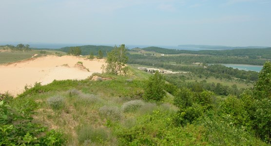
Kerry Kelly 2006 |
Last updated: April 10, 2015