2018 Woolsey Fire

a map of the entire Santa Monica Mountains region with outlines for burn areas during the Woolsey Fire
Map of Woolsey Fire burn area.

National Park Service


two firefighters walking through a burned area post-fire with views of a coastline
National Park Service rangers assessing federal property post-Woolsey Fire.

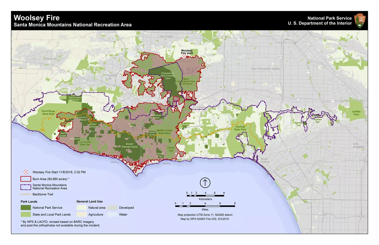
National Park Service

The destructive Woolsey Fire started on Nov. 8, 2018, near the Santa Susana Field Laboratory above Simi Valley, near the boundary between Los Angeles and Ventura counties. Santa Ana winds pushed the fire in a southerly direction the first day. It then crossed the 101 Freeway between the San Fernando Valley and the Conejo Valley and headed into the Santa Monica Mountains.

Santa Monica Mountains National Recreation Area (SMMNRA) sustained significant damage from the Woolsey Fire. The fire burned almost 100,000 acres of land managed by several partners, including the National Park Service, California State Parks, the Mountains Recreation and Conservation Authority, and the Santa Monica Mountains Conservancy.

More than 21,000 acres of National Park Service land burned, which represents 88% of NPS land within SMMNRA. Most of Western Town at Paramount Ranch was destroyed, as well as the 1927 Peter Strauss Ranch house, the Rocky Oaks ranger residence and museum building, the Arroyo Sequit ranger residence, and most of the UCLA La Kretz Field Station.

The Woolsey Fire burned more acres within SMMNRA than any other fire in recorded history. Prior to the Woolsey Fire, the biggest park fire was the 1993 Green Meadows Fire at 38,000 acres. The 1970 Clampitt Fire burned 115,537 acres, but it did not burn nearly as much within the recreation area.


Fire Ecology and Wildlife in the Santa Monica Mountains

 
a large wildfire in a hilly landscape
The Woolsey Fire as seen from Mulholland Drive overlooking King Gillette Ranch.

National Park Service

Though fire is a natural part of the ecosystem, too much fire can harm plant communities, reduce wildlife habitat, and actually increase future fire risk. Historically, scientists believe that coastal Southern California only had a fire every 100 years or so. Current fires (more than every 20 years) are not natural.

If the landscape burns more than once in a 20-year span, invasive weeds and grasses can establish themselves, making the area even more prone to fire. Invasive weeds and grasses, also known as “flashy fuels,” burn quickly and are more susceptible to wind-driven flames.

In general, large animals like deer, coyotes, bobcats, and mountain lions can cover lots of ground and may be able to escape flames. Smaller animals have a much more difficult time. Reptiles and amphibians try to burrow underground.

Of the 13 mountain lions with working radio-collars in and around the Santa Monica Mountains at the time of the Woolsey Fire, 11 of those mountain lions survived and two succumbed to the fire or impacts of the fire.


Prior to the fire, there were four adult bobcats with radio collars. Their home ranges were burned but they managed to thrive and find the resources they needed to continue surviving. Two of them stayed in the original fire zone and two moved to unburned areas.


The Chumash Fire Department Helped Protect Cultural Sites

 
Chumash firefighter
Chumash firefighters find a bead in the ashes of the Woolsey Fire.

National Park Service

The Chumash Fire Department, based out of the Santa Ynez Reservation and a division of the tribal government that is devoted to fire, emergency medical and disaster preparedness services, was ordered up as a Suppression and Cultural Specialist Resource during the fire.

This fire department is rare as they are one of only a few nationwide that are trained in the preservation of their culture.

The job for these Chumash firefighters was to help fight the fire while protecting prehistoric Chumash cultural sites in the Santa Monica Mountains. When the fire's progression stopped, they worked with equipment operators and their supervisors to coordinate the rehabilitation of the land that was distributed by the suppression efforts. When the fire was put to rest and the Burned Area Emergency Response (BAER) Team was mobilized, they assisted in assessing sites that could be potentially impacted in the future by erosion and debris flow.

Read about their work in an
LA Times story titled "In the Ashes, a Search for their Ancestral Past."


The Burned Area Emergency Response (BAER) Team

 
Woolsey Fire BAER Team
Members of the Woolsey Fire Burned Area Emergency Response (BAER) Team.

National Park Service

A Burned Area Emergency Response Team is called upon when catastrophic wildfires pose a post-fire threat to human life and property and cultural and natural resources. The Woolsey BAER Team compiled an emergency assessment based upon information from field reconnaissance, satellite imagery, spatial models, relevant literature, management plans, GIS databases, and discussions with stakeholders. Findings from the assessment helped determine whether emergency actions were needed on federal land and identified stabilization treatments to feasibly mitigate post-fire threats to values located within or downstream from the burned area.

BAER Team efforts aimed to minimize threats by prescribing and implementing emergency treatments that reduced the damage to life or property. They also stabilized and prevented further unacceptable degradation to natural and cultural resources resulting from the effects of the fire.

Read the "
story map" of the Woolsey Fire.


Efforts to Rebuild and Recover

After the Woolsey Fire, the park received a congressional appropriation for disaster recovery and started a public planning process immediately. The news releases below chart the recovery, including preparing the environmetal assessment that was finalized in July 2022.

 
Loading results...

    Last updated: March 3, 2023

    Park footer

    Contact Info

    Mailing Address:

    26876 Mulholland Highway
    Calabasas, CA 91302

    Phone:

    805 370-2301

    Contact Us