|
NATIONAL PARK SERVICE
Mountain Goats in Olympic National Park: Biology and Management of an Introduced Species |

|
| Mountain Goat Herbivory |
CHAPTER 11:
Photographic Comparisons: A Qualitative Appraisal of the Influence of Climate and Disturbances on Vegetation, 1915-1990
E. G. Schreiner and J. E. Burger
In the previous chapter we described how vegetation responded quantitatively to decreasing mountain goat density from 1983 to 1992. Photographs taken before goats were introduced compared with repeat photographs taken later allowed us to extend the evaluation of vegetation in relation to mountain goat herbivory further back in time—albeit qualitatively. We report results from an ongoing study of long-term changes in subalpine vegetation; photographs from Klahhane Ridge are presented because we have not completed work elsewhere in the park. Our objective was to characterize historic changes in vegetation and soils with respect to climate, disturbances (such as fire and windthrow), mountain goats, and humans.
Photographs were selected for picture quality and age rather than preconceptions that a repeat photograph would produce a specific result. Poor focus was the main reason photographs were rejected, but some pictures were not used because the view was too distant or too hazy for changes to be observed or because we could not locate the site. Several visits to a given site were sometimes required to obtain the best correspondence of plant phenology and snow patch patterns. Dominant plant species were recorded at the time scenes were rephotographed.
Our general approach was to compare photographs taken before goats were introduced or when they were at low density with photographs taken when density was high. Later, photographs taken when density was high were compared to those taken after the Klahhane Ridge goat subpopulation was reduced. We compared general features, including aspect, type of view (distant, moderately distant, close), plant community type(s), and noted whether or not the scene was the same as that shown in other pairs. Differences (if any) in each community were described and then tallied as increases, decreases, or no changes in vegetation, amount of exposed soil, and goat sign (Appendix A1). The term community view refers to individual communities within a picture and photographic pair refers to pictures of the same landscape taken at two different times. Plant community names follow those of Pfitsch and Bliss (1985) and Appendix A2. Forces driving changes included goats, humans, fire, and climate change, or combinations thereof. Interpretations are conservative; unless a single cause of change was clearly identifiable (e.g., fire), all contributing factors were considered.
Sixty-six photographic pairs illustrated landscape changes from 1915-20 to 1990. This interval covers the time before goats were introduced through the subpopulation peak in the late 1970's to 1990 when only a few goats remained. Comparisons cover about 4.7 km2 from about 1,400 to 1,900 m elevation. Eleven scenes are presented; the remainder are available in Olympic National Park files (J. E. Burger, Klahhane Ridge comparison photographs, Olympic National Park, unpublished report). The photographic comparisons document changes primarily on goat summer range; we have no comparisons from lower-elevation winter ranges.
Climate and Fire
During 1915-90, periods of low summer precipitation (July-August) occurred in 1915-29, 1941-45, 1957-60, 1968-73, and 1980-86 (see Fig 4). Snowpack fluctuations did not parallel summer precipitation. For example, from 1968 to 1973, a relatively high April snowpack was followed by low summer precipitation. At Hurricane Ridge, April snowpack began to decline in 1949, reached a 30-year low in 1979-80, and has remained low since. Mean July-August temperature increased fairly rapidly (from -12 to 14° C) from 1910 to 1925, continued a more gradual increase to around 1960, and fluctuated near 15° C from around 1960 to 1990.
Plant succession induced by climate change was visible mainly on north-facing slopes initially photographed around 1915-40 (Plate 1). Heath-shrub communities dominated by Phyllodoce empetriformis and Cassiope mertensiana were invaded by subalpine fir, especially in concave landscapes where snow accumulates (Plate 2). Herbaceous vegetation increased in some sites with late-melting snow and stayed remarkably unchanged in others (Plate 3). No tree invasion was observed in the drier ridge-top fellfield (Plate 4), unstable herb meadow, or Phlox—Festuca communities. The results of forest succession following fires are visible in several photographs (Plate 5).
Mountain Goats
Modifications of vegetation and soils by mountain goats were visible even though goat effects were superimposed on those driven by climate, fire, and humans. Effects were most visible on south- and east-facing slopes and seemed to be influenced by goat density. Comparisons were made during 3 periods of differing goat density: 1981-82, just after peak goat densities; 1985-86, medium density (following removal of 181 goats); and 1990, low density (following more removals, an estimated three goats remained).
Photographic pairs of the 1950's through the 1970's compared with 1981-82 in unstable herb meadow, ridge-top fellfield, and Phlox—Festuca communities consistently showed increased bare mineral soil, reduced total plant cover, formation of wallows, and an increase in the number of trails (Plates 6-9). Three of four views of scree slopes from the 1960's showed an increase in the number of wallows or the formation of new trails. Of the 30 plant-community views in these pictures, 11 (37%) showed no change, 14 (47%) showed reduced total plant cover, and 10 (3%) had more bare mineral soil (Table 32). These changes were attributable to goats in 12 (40%) instances, to natural events in 11 (37%), and to a combination of natural events and goats or people in 5 (17%).
The 1985-86 retakes produced more variable results (Table 32) because time intervals differed considerably (i.e., 5-70 years). Goat density at the time the initial photographs were taken ranged from zero (pre-goat) to the highest recorded (late 1970's; Houston and Stevens 1988); density declined from 1981 to 1984. Nearly half of the plant community views (42%) showed no change—a few showed tree invasion (17%). Scenes from the 1960's compared with 1985-86 showed increased bare soil. Those from the 1970's compared with 1985-86 tended to show a decrease in the number of wallows and that the mineral soil component (fines) at the surface of wallows had disappeared from scree slopes (Plate 10). An increase in total plant cover was often observed in the 1985-86 photographs compared with those from 1981 to 1982.
Short-term comparisons of the 1981-82 and 1985-86 photographs with those of 1990 (Table 32) showed that vegetation evidently responded to reduced goat density. Increased total plant cover was visible in all 10 views. Three of the 10 views showed a decrease in disturbance-oriented plant species, and 7 showed an increase in the abundance of Festuca idahoensis. Nine of 10 views exhibited a decrease in the amount of bare ground, which suggested that substrates had become less disturbed. Changes were attributed to reduced goat density in 8 of the 10 views.
Table 32. Changes in vegetation and soils between photographic pairs.
Results represent the number of times a change was observed for each
plant community type within a photographic pair.
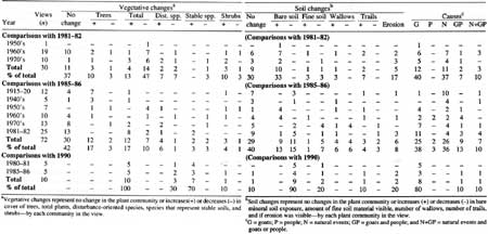
(click on image for a PDF version)
Mountain goats were observed using small rocky outcrops on south-facing slopes among stands of subalpine fir when goat density was high (Plate 11). Even though goats regularly used north-facing slopes among subalpine fir during summer hot spells, they infrequently used south slopes among the trees (Stevens 1979). The level of use on south-facing rocky outcrops among the trees, however, was sufficient to cause a substantial reduction in plant cover. One such rocky outcrop at midslope south of Klahhane Ridge exhibited dramatic recovery between 1980 and 1986 (Plate 11). Increased cover on this site occurred sooner than other, more preferred, sites. This outcrop was evidently among the first to be abandoned by goats as densities were lowered, hence the rapid recovery. Species exhibiting increased cover included Artemisia ludoviciana and Bromus sitchensis.
Changes in which major plant community components such as Artemisia ludoviciana were greatly reduced or eliminated by herbivory are best illustrated by Plate 9 beginning in 1970. These comparisons of an unstable herb meadow community showed loss of the Artemisia by 1982, continued absence (or cover so low it is virtually undetectable) in 1985, and its reappearance in 1990, when an estimated three goats remained. This type of change might be attributed to annual variations in weather except that (1) the photographs span seasons of both high and low precipitation (Artemisia was abundant in 1970, a dry summer following wetter summers, and was greatly reduced by 1982, which was also a dry summer following wetter summers); (2) permanent-plot data did not show the wholesale loss of Artemisia that would be expected if weather were the cause (Schreiner 1987); and (3) Artemisia remained undetectable in the 1985 Plate 9 photograph even though it had reappeared by 1985 in another Klahhane Ridge site (i.e., in another location, Artemisia was undetectable in 1980 and reappeared in 1985 along with several other species because effective goat density had been reduced there earlier [see Plate 11]). In other words, Artemisia cover seemed to reflect goat densities rather than weather or snowpack patterns. This view is consistent with the finding of Pfitsch and Bliss (1985) who noted that Artemisia was a preferred forage of mountain goats.
Interpretation
The analysis of photographic pairs expanded our understanding of vegeation dynamics on Klahhane Ridge in time and space. We observed no changes in plant communities typified by late-melting snow (usually with Antennaria lanata or Carex nigricans). Impressive numbers of Abies lasiocarpa invaded Phyllodoce empetriformis meadows. Plant succession following fire was evident in some scenes but did not seem to play a major role in vegetative changes of nonforested areas. Drier communities on south slopes exhibited decreases followed by increases in plant cover that was inverse to mountain goat density. The results of human trampling were also evident, often in combination with vegetative and soil alterations associated with mountain goats.
Tree invasion into heath communities, as observed on Klahhane Ridge has been reported throughout western North America (Rochefort et al. 1994). Brink (1959) reported massive invasions of Abies lasiocarpa and Tsuga mertensiana into meadows of the coastal mountains of British Columbia, Canada, from 1920 to 1940; invasions also occurred from 1919 to 1950 in the Cascade Mountains of Washington (Franklin et al. 1971b; Lowery 1972; Henderson 1974; Heikkinen 1984). Tree incursions into subalpine meadows elsewhere in the Olympic Mountains occurred during 1923-60 (Fonda and Bliss 1969; Kuramoto and Bliss 1970; Agee and Smith 1984). However, a recent study of invasions of A. lasiocarpa at Heather Park (see Plate 2) showed that most tree invasion took place considerably later (1945-84) than that reported elsewhere (A. Woodward and E. Schreiner, unpublished manuscript, College of Forest Resources, University of Washington, Seattle). Invasion of trees into many subalpine meadows has been correlated with changing temperature and snowpack (Rochefort et al. 1994).
The photographs allowed us to record changes in goat summer range that were not measured in permanent plots. For example, we saw a major shift in the relative abundance of rocks and bare mineral soil in goat wallows, Active wallows on scree had mineral soil at the surface that was no longer visible after goats stopped using them, The long-term ramification of this may be to change the course of plant succession because the ability of seeds to germinate is closely linked to substrate type (e.g., organic matter, mineral soil) and particle size distribution (Harper 1977). We are unable to predict the consequences of substrate changes, but the senior author has observed that the dominant vegetation of scree and talus slopes elsewhere in the Olympics seemed to be controlled by the size of particles in the substrate.
Plant communities on southern exposures, ridge tops, and scree slopes of Klahhane Ridge have evidently started to return to the plant composition that occurred before the high density of goats was present. Photographs from before, during, and after the peak of goat density in the late 1970's exhibit trends in plant cover consistent with this hypothesis. Plant species such as Festuca idahoensis, a bunchgrass often consumed by goats, decreased as goat density increased and then increased as goat density decreased. By contrast, disturbance-oriented species such as Achillea millefolium increased as goat density increased and decreased as goat density decreased. We do not have quantitative measurements of vegetation change as goat density increased, but qualitative changes observed as goat density declined parallel those measured in permanent plots. Photographic comparisons, then, also caused us to reject the null hypothesis that reducing mountain goat densities will not result in changes to the relative abundance of plant species. Moreover, photographic comparisons documented changes in the relative abundance of plant species as mountain goat densities increased.
Plates

|
| Plate 1. |
Location
View to the northwest of Heather Pass-First Divide and First
Top, from the ridge east of Second Top (elevation 1,798 m)
Photographers
E. B. Webster (R. Dalton collection), circa 1915-20's (from B/W copy neg.)
J. Burger, 19 July 1986 (50-mm lens on Technical Pan)
Vegetative changes
Interval of circa 65-70 years
Middleground and background
The formerly bare slope in the center and right
foreground is now being invaded by Abies lasiocarpa and
Lupinus latifolius. However, the late snowmelt area at the lower
left corner is still bare. Abies lasiocarpa have not become
established in the area of the pass where snags persisted in the Webster
photograph. The maintained trail is visible by 1986. The forested areas
around the pass are more dense, but this seems to be caused by
individual tree growth rather than by establishment of new trees.

|
| Plate 2. |
Location
Ed Webster and the view of the cirque north of Second Top (the peak
south of Heather Pass-First Divide) taken from the trail east of
the pass (elevation 1,675 m)
Photographers
T. Chambers collection, circa 1915-20's (from B/W copy neg.)
J. Burger, 19 July 1986 (28-mm lens on Technical Pan)
Vegetative changes
Interval of circa 65-70 years
Foreground and middleground
The meadow has been invaded by Abies
lasiocarpa and Lupinus latifolius. The solifluction lobes are
no longer visible (though the increased plant cover may obscure them).
By 1986, Abies lasiocarpa was also established in formerly bare
areas in the upper meadow. The maintained trail is visible in the lower
right corner of the 1986 image.
Background
The far, late-snowmelt slope is still bare. Though a
series of years with light snowpack probably allowed the tree
establishment in the meadow, this area evidently received enough snow to
prevent tree invasion.

|
| Plate 3. |
Location
Klahhane Ridge, about 1 km east of Klahhane Saddle; view east
toward Rocky Peak (elevation 1,860 m)
Photographers
G. Fagerlund, 2 September 1956 (from ONP 2 1/4 neg. #3433)
J. Burger, 23 August 1986 (28-mm lens, on Technical Pan)
Vegetative changes
Interval of 30 years
Foreground and middleground
The trail is new, but the meadow vegetation of
Carex spp. and Antennaria lanata seems unchanged. Some of
the Abies lasiocarpa in the background have died, The dead ones
are close to the trail (right clump) or near a trail frequently
used by goats (left clump).

|
| Plate 4. |
Location
View to the northeast from the slope just north of Heather Pass/First
Divide with the lowlands around Sequim in the background (elevation
1,722 m)
Photographers
E. B. Webster (R. Dalton collection), circa 1915-20's (from B/W copy neg.)
J. Burger, 19 July 1986 (50-mm lens on Technical Pan)
Vegetative changes
Interval of circa 65-70 years
Foreground and middleground
Because the original photograph is slightly fuzzy, it is difficult to
make exact comparisons. The foreground has large clumps of Potentilla
fruticosa in 1986 that weren't evident in the original. However, the
small, dark plant clumps visible in the original are no longer present.
The only other change is the Abies lasiocarpa growth.

|
| Plate 5. |
Location
Klahhane Ridge, view to the northwest over the meadow where the trail
begins its descent toward Lake Angeles with the rocky shoulder of Second
Peak in the background (elevation 1,798 m)
Photographers
C. N. Webster, circa 1940 (from B/W neg.)
J. Burger, 24 August 1985 (50-mm lens, from color)
Vegetative changes
Interval of circa 45 years
Middleground and background
By 1985, there is more bare ground along the lip of the meadow. On the
left edge of the 1985 photograph, a wallow is visible. There has been
considerable regrowth among the burned snags both on the meadow lip and
in the far right background burn.

|
| Plate 6. |
Location
North side of Klahhane Saddle, about 5 m out on trail toward Heather
Park (elevation 1,798 m)
Photographers
J. W. Thompson (#1), 1960-64 (from color)
D. B. Houston, 12 August 1981 (from color)
Vegetative changes
Interval of circa 20 years
Though the phenology seems relatively similar, there are some
differences in the abundance of flowers.
Foreground and middleground
There are fewer flowering plants evident in 1981 (primarily Phlox
diffusa, Penstemon davidsonii, and Erigeron compositus), and
there is a general decrease in plant cover.

|
| Plate 7. |
Location
View of large blowout site on Klahhane Ridge, just east of where trail
turns north to descend to Lake Angeles; view east from southeast of
trail along the ridge crest (elevation 1,830 m)
Photographers
L. Lack (#2), June 1962 (from color)
D. B. Houston, 21 August 1981 (from color)
Vegetative changes
Interval of 19 years
This bare area may not have been started by goats,
but heavy goat use exacerbated the damage by wallowing, removing plant
cover, and increasing the area's susceptibility to wind erosion.
Middleground and background
By 1981, the middle and upper left of the blowout
have eroded deeper and larger with whole clumps of turf gone. The
smaller, bare areas to the left of the large one also eroded more
deeply. There are wallows visible on the center right slope in 1962; by
1981, this area seems to have less plant cover, and some disturbed
patches are still visible. The juniper clumps along the right edge are
smaller, and one is no longer visible.

|
| Plate 8. |
Location
View of slope above (east of) large blowout site on Klahhane
Ridge, just east of where trail turns north to descend to Lake
Angeles (elevation 1,830 m)
Photographers
L. Lack (#4), 31 August 1964 (from color)
D. B. Houston, 21 August 1981 (from color)
Vegetative changes
Interval of 17 years (also see Plate 7 for overall view)
Foreground and middleground
The whole area has less plant cover and much more churned-up bare ground
by 1981. The wallows on the left are much deeper, and new wallows
developed along the left edge and toward the center. There is an
increase in Achillea millefolium.

|
| Plate 9a. |
Location
Klahhane Ridge, view of the east-facing slopes of the cirque north of
Klahhane Saddle, from just below the trail circa 100 m before the trail
begins switchbacks up to Second Divide (elevation 1,675 m)
Photographers
B. Moorhead (#1), 27 August 1970 (from color)
D. B. Houston, 12 August 1981 (from color)
Vegetative changes
Interval of 11 years
Foreground and middleground
There is a marked decrease in the plant cover, especially the
light-colored Artemisia ludoviciana, on the middle and
foreground slopes.
Background
There is less plant cover on the far slope above and below the
trail.

|
| Plate 9b. |
Location
Klahhane Ridge, view of the east-facing slopes of the cirque north of
Klahhane Saddle, from just below the trail circa 100 m before the trail
begins switchbacks up to Second Divide (elevation 1,675 m)
Photographers
D. B. Houston, 12 August 1981 (from color)
J. Burger, 6 August 1985 (50-mm lens, from color)
Vegetative changes
Interval of 4 years
The Klahhane Ridge goat population was drastically reduced.
Foreground and middleground
There seems to be a slight increase in plant cover on the middle and
foreground slopes, though this may be caused by a difference in
phenology making the plants look more robust.
Background
There is no evident change.

|
| Plate 9c. |
Location
Klahhane Ridge, view of the east-facing slopes of the cirque north of
Klahhane Saddle, from just below the trail circa 100 m before the trail
begins switchbacks up to Second Divide (elevation 1,675 m)
Photographers
D. B. Houston, 12 August 1981 (from color)
J. Burger, 1 August 1990 (50-mm lens on Pan-X)
Vegetative changes
Interval of 9 years
The Klahhane Ridge goat population was virtually eliminated.
Foreground and middleground
There is an increase in plant cover on the middle and foreground slopes
(primarily Artemisia ludoviciana, Phacelia hastata, and
Cirsium edule).
Background
There is increased plant cover above and below the trail on the
center right slope.

|
| Plate 10. |
Location
View of the slope above the Klahhane switchback trail circa 30 m
before the saddle (elevation 1,792 m)
Photographers
D. Pike, 30 June 1978 (from color)
J. Burger, 15 July 1985 (50-mm lens, from color)
Vegetative changes
Interval of 7 years
The goat population on Klahhane Ridge was reduced by about
80%.
Foreground
Areas below the rock along the right edge and along the left edge have
more plant cover by 1985, mostly Achillea millefolium and
grasses. This may be partially due to phenologic differences. Notice the
large difference in proportion of fine soils between the two
photographs. The bottom photograph shows rock (talus size) compared to
finer fragments in the top image.

|
| Plate 11. |
Location
The Klahhane Switchback trail, four switchbacks above the junction with
the Hurricane Ridge trail; view to the southwest (elevation 1,675 m)
Photographers
M. Hutchins, July 1980 (from color)
J. Burger, 15 July 1986 (50-mm lens on Plus-X)
Vegetative changes
Interval of 5 years
The Klahhane goat population was reduced by
approximately 80%. Though the foregrounds match well, it was difficult
to match the perspective; Hutchins probably used a short telephoto lens.
Note that because people shortcut the trail switchback in front of the
center rock, this area is not likely to recover completely, even in the
absence of goats.
Foreground and middleground
The phenology is later, but there is an obvious
increase in plant cover by 1985, mostly Cirsium edule, Artemisia
ludoviciana, Hydrophyllum fendleri, Phacelia hastata, and
grasses.
Background
Plant cover on the rocky outcrop increased.
| <<< Previous | <<< Contents >>> | Next >>> |
chap11.htm
Last Updated: 12-Dec-2007