|
NORTH CASCADES
Historic Resource Study North Cascades National Park Service Complex, Washington |

|
EARLY IMPRESSIONS: EURO-AMERICAN EXPLORATIONS AND SURVEYS
"Washington Territory" has within its limits portions as well explored and others as nearly unknown as can be found west of the Mississippi . . . . The interior portion of this section is but imperfectly known. The land office surveys north of the Columbia have as yet made but little progress. . . .The narrative of Lewis and Clark, the book on Oregon Missions by Father de Smet. . .and Irving's Astoria...are the chief publications of value on this ground. They serve merely to show that the country bordering the Rocky Mountains between 46° and 49° [parallels] on both sides, is still a fine field for exploration. [1]
Euro-American exploration of the enigmatic territory in and around the northern Cascade Mountains occurred late in the history of the Pacific Northwest. Written records of coastal expeditions first record the sighting of the Cascade Range in the eighteenth century. While maritime explorers plied Pacific waters, inland expeditions first penetrated the heart of the American Northwest in the late eighteenth century, slowly pushing to the north, east, and south of the formidable North Cascades. Before the second decade of the nineteenth century closed, the first recorded journey into today's North Cascades National Park had been accomplished.
Fur traders were among the first to spread knowledge of the North Cascades. Year after year these adventurers searched for improved routes through the territory in order to expedite the transport of their furs to market. Following these explorations, the United States government expressed an interest in the remote region and assigned the military to conduct general reconnaissances there. Simultaneous with government efforts, private railroad concerns dispatched survey and mapping teams to locate cross-country railroad lines. Nearly all of these expeditions had the same goal: the improvement of transportation and communication networks in the growing territory. Everyone sought to find "the most feasible route" through the mountains.
For a period of nearly ninety years intrepid individuals explored the North Cascades region. Access to this remote area was difficult. Initially, travelers used shovel-nosed canoes along major rivers as a means of reaching into the foothills of the mountains. When river navigation became impractical explorers continued on foot, often following well-worn or remnant Indian trails. Many of these trips were documented; probably more were not and go unrecognized to this day. The diaries or journals which were maintained recorded in detail everything from natural and cultural features of the area to the virtues of huckleberries. Through these diary and journal records the timber and mineral resources of the North Cascades as well as pertinent physiographic information became known, and the mysteries of the region slowly unraveled. Further exposure came with the mapping of the area beginning in the late 1850s, although this early work was often inaccurate in its depiction of the terrain.
This chapter discusses documented explorations into the North Cascades. First, expeditions along the coast recording inland views of the mountain range are noted, followed by regional explorations occurring outside the boundaries of the national park. In turn, interior explorations entering today's park are addressed in chronological order, to the close of the exploration era in 1900. As with each chapter, we will end with concluding remarks and management recommendations.
MARITIME EXPLORATIONS
Rising higher than 10,000 feet with a perpetual cover of snow and ice, Mount Baker is the most prominent physical feature in the proximity of North Cascades National Park. This peak became a familiar reference point for European and American maritime explorers long before the interior of the North Cascades was reached.
The Spanish were the first to record Mount Baker's existence although they, quite possibly, were not the first whites to see the mountain. In 1790, Ensign Manuel Quimper of the Spanish Navy set sail from Nootka, a temporary settlement on Vancouver Island, with orders to explore the newly discovered Strait of Juan de Fuca. Accompanying Quimper was first-pilot Gonzalo Lopez de Haro who drew detailed charts during the six-week expedition. Although Quimper's written journal of the voyage makes no reference to the mountain, one of Haro's manuscript charts includes a sketch of a prominent peak in the area of Mount Baker. [2]
One year later, in 1791, the renowned British explorer George Vancouver left England. His mission was to survey the northwest coast of America. After sailing around the Cape of Good Hope and wintering in the Hawaiian Islands, Vancouver and his crew reached the Pacific Northwest coast in 1792. While anchored in Dungeness Bay on the south shore of the Strait of Juan de Fuca, third lieutenant Joseph Baker made an observation which Vancouver recorded in his journal:
About this time a very high conspicuous craggy mountain . . . presented itself, towering above the clouds: as low down as they allowed it to be visible it was covered with snow; and south of it, was a long ridge of very rugged snowy mountains, much less elevated, which seemed to stretch to a considerable distance . . . the high distant land formed, as already observed, like detached islands, amongst which the lofty mountain, discovered in the afternoon by the third lieutenant, and in compliment to him called by me Mount Baker, rose a very conspicuous object . . . apparently at a very remote distance. [3]
Six years later the official narrative of this voyage was published, including the first printed reference to the mountain. [4]
By the mid-1850s, Mount Baker had become a well-known feature on the horizon to the various explorers and fur traders traveling in the Puget Sound region. Isaac I. Stevens, the first governor of Washington Territory, wrote about Mount Baker in 1853:
Mount Baker . . . is one of the loftiest and most conspicuous peaks of the northern Cascade range; it is nearly as high as Mount Rainier, and like that mountain, its snow-covered pyramid has the form of a sugar-loaf. It is visible from all the water and islands . . . [in Puget Sound] and from the whole southeastern part of the Gulf of Georgia, and likewise from the eastern division of the Strait of Juan de Fuca. It is for this region a natural and important landmark. . . [5]
EARLY REGIONAL EXPLORATIONS
While Vancouver and Baker explored the Northwest from the deck of a ship, others began to penetrate the immense territory on foot. In 1793 fur trader Alexander MacKenzie completed an overland journey across northern British Columbia to the Pacific Ocean. By following the Peace and Parsnip Rivers to their headwaters, then crossing mountain summits to reach the Fraser River, MacKenzie was successful in reaching the coast. Although MacKenzie is recognized as being the first white man to accomplish such a feat, he was mistaken in his belief that he had followed the Columbia River to the Pacific. [6]
After MacKenzie's significant journey, Americans Meriwether Lewis and William Clark set out in 1804 with orders to "observe the territories . . . from the north of the Missouri to the Pacific Ocean," and complete the explorations that MacKenzie had initiated eleven years earlier. With the Louisiana Purchase of 1803, a vast region formerly closed to American traders was now open. One of the primary missions of the Lewis and Clark expedition was to explore the various resources of the newly acquired land and determine the feasibility of a transcontinental trade system using the Missouri River. [7] Their route eventually led them from the Snake River to the Columbia River, and west to the Pacific Coast.
As Americans began to move westward, the British, who had several holdings in the Northwest, sought to strengthen their claims to the territory. The North West Company enlisted Simon Fraser, a company employee, to continue the exploration efforts initiated by MacKenzie. In 1808 Fraser set out to explore what he, too, believed was the Columbia River. Because of treacherous waters he was able to navigate the river only as far as MacKenzie had some fifteen years earlier. Frustrated, Fraser calculated his position and realized, much to his chagrin, that neither he nor his predecessor had been following the Columbia River. In recognition of his journey, however, Fraser named the river after himself. [8]
At the same time Fraser was exploring this watercourse, a fellow North West Company employee was wintering, unknowingly, at the headwaters of the Columbia River. Looking for a trade route for the North West Company, David Thompson led a party down the Columbia to its mouth in 1811. [9] In doing so, he became the first white to traverse the Columbia from its headwaters to the Pacific Ocean. [10]
A week after Thompson arrived at Fort Astoria near the mouth of the Columbia River, David Stuart, an employee of the American Fur Company, set out to establish a trading post at the confluence of the Okanogan and Columbia Rivers, a site northeast of today's national park. [11] Alexander Ross, a member of the Stuart party who would later gain fame for his crossing of the North Cascades, recorded in his journal the daily progress of the canoes as they headed up the Columbia River. By the 29th of August 1811, the expedition had reached the mouth of the Chelan River, and three days later, a site for the new American outpost was chosen. [12]
Because of its prime location along two important waterways, Fort Okanogan remained in operation for many years. Built in 1811 and rebuilt in 1816, the post served as a strategic base camp from which Ross, Stuart, and other explorers ventured out on trading excursions primarily up the Okanogan and Similkameen Rivers into what is now British Columbia. The post was also an important rendezvous point for fur brigades traveling down the Columbia River to the coast. [13] Over the course of four decades the post came under the control of three different fur trading companies before it was abandoned in 1859. [14]
In the mid-1850s a major expedition was launched by the government of the United States to find a practical and economical railroad route from the headwaters of the Mississippi River to Puget Sound. The expedition was led by Washington Territory's first Governor, Isaac I. Stevens.
On the 8th of April, 1853, I [Stevens] was assigned to the duty of exploring a route for the Pacific railroad from St. Paul, or some eligible point on the upper Mississippi, to Puget Sound. My instructions required me to examine carefully the passes of the several mountain ranges, the geography and meteorology of the whole intermediate region, the character, as avenues of trade and transportation, of the Missouri and Columbia Rivers, the rains and snows of the route, especially in the mountain passes, and in short, to collect every species of information bearing upon the question of railroad practicability. . . . As the route was comparatively new and unexplored, it was determined to organize the whole command into two divisions — the eastern division being under my immediate direction, and the western division under Captain George B. McClellan of the Corps of Engineers. . . . [15]
Beginning on the western coast with orders from Stevens to "operate in the mountains until they are thoroughly explored or till driven away by the snow," Captain George B. McClellan made his way to the eastern foothills of the Cascades, traversing the Wenatchee valley of the Columbia River. [16] He eventually reached the foot of Lake Chelan. [17] After crossing the outlet of Lake Chelan, McClellan moved his party northward, reaching the Okanogan River on September 27. The group camped along the river about one and a half miles from "Fort Okinakane [sic], an old and ruinous establishment of the Hudson Bay Company. [18] McClellan described the fort's structures, noting that "little business is now transacted here." The fort's caretaker, Joe Lafleur, informed McClellan that while "there was no pass between Mt. Baker and the Hudson's Bay Company's trail from Okinakane to Langley [in British Columbia]," there was a foot trail that led from the headwaters of the Methow River over to Puget Sound. [19]
The following seven days were spent exploring this route and an alternate route along the Twisp River. McClellan directed a member of the expedition party, Lieutenant Johnson Kelly Duncan, to navigate the Methow River as far as practical. Continuing on foot, Duncan surveyed the region "until the roughness of the trail and the barometer assured him of its unfitness for a railroad." [20] McClellan examined the Twisp River, noting: "I was by this time quite certain that this route would not answer for a railway but determined to keep on upon the same trail myself until the question could be fairly settled." [21] He followed the valley of the Twisp River until reaching War Creek, which he followed until the trail became impassable for pack animals. He then proceeded "on foot until there was no longer any doubt as to the impracticability of the route." [22] From here, McClellan observed:
The trail is said to pass from this ravine, [War Creek] over a very difficult country [War Creek Pass & Purple Pass] to the stream emptying into the head of Lake Chelan [Stehekin River], then to cross very steep and lofty mountains at the head of that stream [Cascade Pass], and finally to reach the Skagitt [sic] river on the western slope. [23]
After his reconnaissance of the Methow and Twisp River valleys, McClellan and party left Fort Okanogan and proceeded northward to explore the Okanogan River. They eventually headed east to Fort Colville where they met Governor Steven's division and completed their monumental assignment.
Although some scholars believe McClellan was lackadaisical and incomplete in his survey work, his expedition was valuable for many reasons. [24] It provided a wealth of general information that was previously unknown. McClellan was the first to explore the area of the North Cascades as far north as the 49th parallel, documenting various water courses and drainages, oftentimes to their source. He found and verified that the territory was "erroneously laid down on [earlier] maps," and that this northern country was very rugged, refuting former beliefs about the region. [25] It was also McClellan who determined that only two passes in the Cascades appeared promising as railroad routes. Since these passes were in the south, closer to Mount Rainier, the northern Cascade Range would untouched by railroad development for many years to come.
|
| Early Regional Explorations |
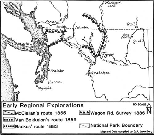
Four years after McClellan's expedition, a civilian group, led by a Major Van Bokkelon, entered the Skagit River from Puget Sound in 1859. Navigating upriver in search of gold, they were the first Euro-Americans known to have penetrated beyond a massive natural log jam in the river. [26] Turning up the Baker River, the party proceeded as far as Baker Lake, where they were stopped by Mount Baker to the northwest. [27]
The next major U.S. Army expedition, which took place nearly three decades after McClellan's, was led by First Lieutenant George B. Backus, Jr., in 1883. The group's assignment was to locate a railroad route through the North Cascades. Accompanied by reporter and mapmaker First Lieutenant George Washington Goethals (who would later gain fame as builder of the Panama Canal), Backus began his expedition in British Columbia. Backus and Goethals traveled west along the Similkameen River and south to the Okanogan River. From the outlet of the Okanogan they headed west to the Twisp River, choosing to follow the north fork (now considered the main branch of the Twisp River) because Backus "was sure from what he had heard the miners say, and learned from the Indians, . . . that the pass [over the Cascade Mountains] was at the head of this branch." [28]
Establishing camp in the vicinity of Silver Peak, Backus and Goethals hiked the remaining five or six miles to the summit of the Cascades. From there they observed a stream flowing westward, believing it to be the Skagit River. Unbeknownst to the explorers the watercourse they saw from their vantage point was probably Bridge Creek, a tributary of the Stehekin River. [29] This point was the limit of their journey; scholars today believe the explorers were near Twisp or Copper Pass, east of today's park boundary.
Three years later, in 1886, a civilian party of explorers approached the North Cascades near the park's northwest boundary. The six surveyors, all residents of Whatcom (now Bellingham), traveled to the north fork of the Nooksack River with the dual objectives of prospecting and locating a wagon route from Bellingham Bay to the upper Skagit River. As they followed the north fork, they detoured time and again to climb a peak or ascertain a drainage's direction. Eventually reaching Ruth Creek, they hiked the watershed to its source, Ruth Mountain. Despite their efforts they apparently failed to find the pass that would have led them down into the broad Chilliwack River valley and into today's park. [30]
EXPLORATIONS WITHIN NORTH CASCADES NATIONAL
PARK
Native Americans had crossed the North Cascades since the earliest times to trade wild hemp and other interior treasures for shells and other goods from coastal cultures. [31] The earliest recorded crossing of the North Cascades by a European, however, was not accomplished until 1814. Alexander Ross, a fur trader in the employ of John Jacob Astor's Pacific Fur Company, first came into the area in 1811 as a member of David Stuart's party representing American interests in the fur trade. It was this party which navigated the Columbia River as far north as the Okanogan and established a trading post there named Fort Okanogan, the first American settlement in the present State of Washington.
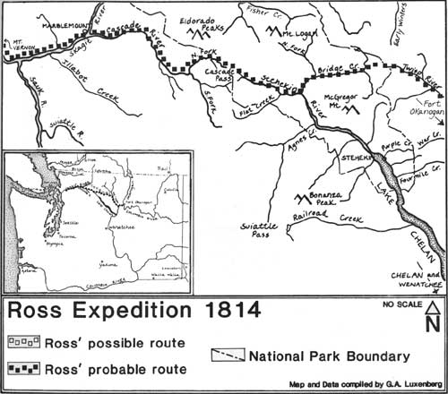
Alexander Ross (1814)
After completing construction of the post the traders explored the surrounding country searching for new river drainages and better overland routes that could expedite travel and the trading of goods. In 1814 Alexander Ross set out to uncover the mysteries of the North Cascades; he would later refer to this journey as "a project of discovery," for Ross claimed that no other Euro-American had ever attempted the undertaking. He planned "to penetrate across land from Okanogan, due west, to the Pacific, on foot, a distance supposed not to exceed 200 miles." Ross was "anxious to see it explored" because, as a fur trader, he believed that part of the country "held out a good prospect for extending the [fur] trade." [32]
|
| Ross Expedition 1814 |
Ross' travels are known today because of the daily journal in which he recorded his daily progress and observations in some detail. Unfortunately, he often was not specific in his descriptions of land forms and features viewed along the way and as a result there is much confusion regarding his actual route. Some scholars believe that Ross traveled up the Methow River, crossed over Twisp Pass, headed up Bridge Creek to Rainy Pass, and then dropped down to Granite and Ruby Creeks, eventually meeting the Skagit River. A more widely-held theory is that Ross traveled the Methow River crossing over Twisp Pass, then headed down Bridge Creek to the Stehekin River. From here he headed upriver, crossing Cascade Pass and traveling down the Cascade River to the Skagit River. [33]
On July 24, 1814, Alexander Ross departed Fort Okanogan with a white guide and two Indian assistants, and traveled west to the Methow River. Unable to follow the Methow because of its rocky sides and serpentine course, they struck off up Squaw Creek maintaining a due west course. [34] By the fifth day the Ross party was over Copper Pass and headed in a southerly direction down Bridge Creek. The surrounding country with its almost impenetrable forests remained gloomy, and Ross noted: "A more difficult route to travel never fell to man's lot." [35]
On the sixth day the party ascended a ridge from which the view to the east revealed steep and abrupt land and a watercourse flowing in the opposite direction. Those who believe Ross traversed the mountains through Cascade Pass conclude that he reached the pass at this point. [36]
When the party's guide fell sick Ross was forced to continue the journey with one companion. On the fifth of August he and his companion traveled "through a delightful country, of hill and dale, wood and plains" and observed "a good many beaver lodges along the little river [Skagit River]," some small lakes, and grazing deer in "herds like domestic cattle." [37] This was Ross' last journal entry describing the region. The following day he was forced to retreat after his companion deserted him. Retracing his steps he found his assistant at the ill guide's encampment. Despite efforts to rally his fellow travelers to resume the journey, Ross was unsuccessful and the hungry, fatigued, and disappointed explorers ". . . turned [their] faces towards home," arriving at Fort Okanogan thirty days later. Only after the party returned home did Ross' guide inform him that had he continued on from "point turn-around," he would have reached the Pacific Ocean in four days. [38]
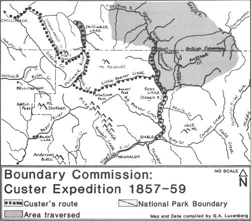
Nearly half a century after Ross made his intrepid crossing of the North Cascades, the mountains were again subject to scrutiny, this time by the federal government. During the years 1857 and 1859, the international boundary between Great Britain (now Canada) and the United States was surveyed along the 49th parallel from the Pacific Ocean to the Rocky Mountains. The boundary was established when Great Britain and the United States signed the Treaty of Washington in 1846. The terms of this treaty were clear, specifying the 49th parallel as the official dividing line. Extending across rugged and precipitous mountains, the boundary was marked through country still virtually unknown. Today, this international boundary marks the northern limits of North Cascades National Park.
Boundary Commission: Henry Custer's Explorations (1857)
Actual survey work began in 1857. A Northwest Boundary Commission was created that year, operating under the authority of the State Department and headed by Archibald Campbell. Campbell hired surveyors astronomers, geologists, naturalists, and artists for the survey team; his principal assistant was Lieutenant John G. Parke, a U.S. Topographical Engineer who served as chief astronomer and surveyor. Other members of the team included George Clinton Gardner, assistant astronomer and surveyor; Joseph S. Harris and Dr. C.B.R. Kennerly, surgeons and naturalists; James W. Alden, artist; Francis Herbst and Henry Custer, topographers; J. Nevine King, quartermaster and commissary; George Gibbs, geologist and interpreter; and R.V. Peabody, guide. Laborers, cooks, packers, axemen, messengers, and Indian guides were also employed in great numbers. Nearly 200 men were recruited at a time when both men and supplies were becoming increasingly scarce and expensive because of the discovery of gold along the Fraser River in 1856. [39]
|
| Boundary Commission: Custer Expedition 1857-59 |
In the late summer of 1857, the party began survey operations at Point Roberts. The Americans worked alone until the spring of 1858, at which time a second survey team arrived from England, supervised by British commissioner Captain J.S. Hawkins. At a joint meeting of the commissions, field operations for surveying and marking the line as far east as the Cascade Mountains were discussed:
. . . it was concluded to be inexpedient at the present time, in consequence of the great expense, consumption of time, and the impracticable nature of the country, to mark the whole boundary by cutting a track through dense forest. It was therefore agreed to ascertain and mark points on the line by the determination of astronomical points at convenient intervals on or near the boundary by cutting a track of not less than 20 feet in width on each side for the distance of half a mile or more. . . [40]
As a means of accomplishing this task it was determined necessary to send a party ahead to blaze a rudimentary trail through the dense vegetation, forests, streams, and mountains. Astronomers and surveyors would then follow. The astronomer would set up stations from which to make astronomical observations while the surveyors were to trace the boundary line with a chain and compass survey. [41] Various materials, including rough iron posts, stone cairns, and wood posts set in earthen mounds, were used as markers to indicate the exact boundary line. [42] The forty-foot-wide swath of cleared vegetation across the land would be a clear demarcation.
By the end of the 1858 season a preliminary survey of the boundary line had been completed from the Skagit River valley approximately 90 miles to the east. By this same date, astronomical observations for three points on the 49th parallel had been completed in the Chilliwack River valley. In the following year the work of surveying and marking the boundary reached eastward from the Skagit to the Columbia River, a distance of about 150 miles. By 1861 the Americans had completed their field work, having placed a total of 161 markers along the international boundary. [43]
The individuals involved in marking the international boundary recorded first glimpses of the region which later became a national park. One of the first general descriptions of the North Cascades was written by Lieutenant Parke:
The forty-ninth parallel . . . traverses a mountainous country, and, excepting a few localities, the entire region is eminently unfit for occupation or settlement. The mountains are rugged and precipitous, and attain great elevations; the ridges and peaks of the Cascade Mountains being covered with perpetual snow. Glaciers were discovered; and during the months of June and July snow to the depth of two feet was encountered on our very route of travel. [44]
James Alden's watercolor sketches are the earliest images of the park's mountains and glaciers. Henry Custer's readiness to climb some twenty mountain peaks and ridges resulted in the earliest and most detailed descriptions of this unfamiliar northern territory. [45] Custer was a Swiss-born topographer who undertook a series of explorations that led him into the Nooksack and Chilliwack River drainages, the rugged Picket Range, and down the Skagit River to Ruby Creek. He was the first Euro-American to spend considerable time in the high elevations of the North Cascades. His May 1866 report to Commissioner Campbell was an invaluable contribution to the general knowledge of the region. The excerpts which follow are drawn from his unpublished forty-seven-page document. [46] Remarkably, much of what Custer documented over a century ago can be observed and sensed today because so little of the land has been disturbed. [47]
On July 12, 1859, Custer received orders to explore the "Ensan Kwatch" (Ensawkwatch) Creek drainage near the 49th parallel. Within days Custer set out ". . . along the regular trail to the Chiloweyuk-lake [Chilliwack Lake], formerly a Hudson Bay brigade trail but now improved by our party and the English, the main route, to reach portions of the Parallel." [48] He followed Ensawkwatch Creek the duration of the day, stopping at dusk to set up camp. The following day he climbed Middle Peak to scout the surrounding country. Describing the geography but including other information, Custer wrote:
The view from here was fine and extensive in all directions of the compass. I leave it to a better pen to describe the sublimity of true Mountain scenery in the Cascade Mountains as seen from a point of such altitude; it must be seen it can not be described. No where do the Mountain masses and Peaks present such strange, fantastic, dauntless, and startling outlines as here. Whoever wishes to see Nature in all its primitive glory and grandeur, in its almost ferocious wildness, must go and visit these Mountain regions. . . . Toward the east the Mountains reach a considerable altitude; and for the first time glaciers. . .were seen to cover the mountainsides to a considerable extent, dazzling in the reflected light of the sinking sun. To the southwest, Mt. Thuskan [Shuksan] and Mt. Baker elevate their hoary and icy sumits [sic] beautiful and majestic from whatever point you may contemplate them. [49]
From Ensawkwatch Creek Custer crossed the headwaters of the Little Chilliwack River. [50] Making his way to the Chilliwack River, "a stream of considerable size flowing in a comparatively wide valley, densely-timbered," Custer followed the river until crossing the "vista of the Parallel, with its piramidial monuments hidden away in the solitude of [the] primitive forest." [51] Working his way past the abandoned encampment of a boundary survey astronomical station, Custer eventually reached Chilliwack Lake where a supply depot had been established.
On the 25th of July Custer was assigned to explore the 49th parallel as far east as the Skagit River. Information regarding this area was "very vague and meagre," and Custer was forced to determine his own route. [52] The following day Custer set out for "Koechehlum" Creek (in British Columbia), ascending that drainage following the faint lines of an Indian trail. Moving in a southeasterly direction along the "Kleguanum" River, Custer climbed a peak later that morning to survey the environs and observed for the first time what he believed was the Skagit River valley.
The next day the party continued up the Kleguanum valley (Silverhope Creek) unknowingly traversing the Fraser and Skagit River divide. By late afternoon they had reached "a broad and well travelled trail" which Custer concluded to be the "Whatcomb" (Whatcom) trail. [53] The party followed the path to the southwest, meeting the Klesilkwa River, then turned to the Northeast, reaching the Skagit River after a short distance. At this location, north of the international boundary, Custer noted:
. . .the Skagit. . . is here already a stream of considerable size, with beautiful clear water and gentle fall, aparently [sic] fit for large canoe navigation. It flows in a valley about 2 miles wide, which however becomes narrower to the North or farther up River. [54]
Having reached his assigned location, Custer set up camp and used the remaining daylight to examine the area. He observed that the Skagit River flows almost due south and "To the west are high mountains which may be properly considered the main back bone of the Cascade Mountains." [55] His mission accomplished, Custer climbed one last unnamed peak before returning to Chilliwack Lake. Overlooking the northeast area of today's park, Custer wrote:
The Mts. to the East of the Skagit rise to considerable height. In the first Ridge we observe 2 Peaks especially prominent, the Shawatum and the Hozomeen. The latter is a huge mass of grayish blak [sic] rock ending in 2 sharp points of considerable altitude. . . . The Mts. toward the South and SE keep the general Character of the Cascade Mts.; while to the East and North East... the sharp, frightful, fantastic outlines of the Cascade Mountains have changed into the tame and gentle outlines apertaining to Mts. with broad and flat sumits [sic], of a table land Character. [56]
On August 8, Custer set out again with a party to explore Chilliwack and Skagit River drainages. This particular expedition would bring Custer well inside the boundary of today's national park. Although Custer's route is somewhat ambiguous, from his journal it is generally interpreted he followed the Chilliwack River, bypassed Brush Creek, and headed to Easy Creek where
a short ascend over a gentle incline brought us finally to the sumit [sic] of the Mountain. The sumit is broad and roomy, covered with fine pasturage, a regular alp such as one sees in the Mts. of Switzerland or Tirol. [57]
After descending the ridge the party reached the headwaters of Brush Creek. Continuing up this drainage, Custer apparently crossed Whatcom Pass. This is believed to be the first known crossing of this isolated mountain pass. [58] Continuing east Custer followed Brush Creek until he reached
. . .the brink of a deep precipice some 2000-3000 feet deep. Below it we discerned the waters of a creek wending its way in a due NE course through a wide gorge in the Mts. This is then undoubtedly the sought for tributary of the Skagit. [59]
Custer was gazing down on Little Beaver Creek. [60]
After a treacherous descent into the canyon of upper Little Beaver Creek, the party continued downstream to the Skagit River. Crossing the river, they located a trail which they followed four or five miles until they emerged into the clearing of the Boundary Commission's Skagit astronomical station. There Custer received orders to "explore & meander the Skagit river for 10 miles to the North of this station & for the same distance to the south of it," and to explore the divide between the Skagit and Similkameen Rivers. [61] Within a few days the group was prepared to depart.
Traveling by canoe Custer and his party explored the Skagit River north of the 49th parallel. Perhaps as a diversion from his assignment Custer waxed lyrical on the region's "Hookle berries":
. . .the Mts. sides were covered with extensive patches. . .the largest & finest of peculiar brownish blue color that could be seen. They are of excellent flavor. To withstand the temptation of a large tract literally covered with these delicious berries goes beyond the moral strength of a white man, much less that of an Indian. To halt & eat & to eat & halt is all you can do under these circumstances. . . [62]
On Saturday, August 27, Custer began his descent of the Skagit River. Less than ten miles from the boundary camp the party encountered difficulties in navigating the river. Downed timber obstructed easy travel and numerous portages were necessary for quite a distance. Farther down, the Skagit was nearly free of obstacles and Custer's progress grew rapid. He wrote:
Nothing can be more pleasant than to glide down a stream like this; the motion is so gentle; the air on the water cool and pleasant; & the scenery, which is continually shifting, occupies eye & mind pleasantly. [63]
Beyond the mouth of a large tributary on the east, perhaps Lightning Creek or Devil's Creek, the river current increased and the party occasionally encountered rapids. That evening, from the camp, Custer was able to observe a large valley in the distance extending to the east about eight or nine miles. He concluded it was the east fork of the Skagit River. Today, scholars believe Custer was viewing Ruby Creek.
Motivated to explore the river farther Custer continued with his three best canoemen, all Indian. Traveling at a speed of about five or six knots, the Indians steered through swift rapids, shouting and singing as they went along. "Our canoe sped on with the rapidity of an arrow," Custer wrote. The river was free of obstacles, but before long, the valley began to narrow and the mountains closed in. After several hours of navigation Custer noted:
. . .we rapidly enter the begining [sic] of a canon. The river flows here between rocky banks, with a swiftness and impetuosity which even makes my expert Indian canoe men feel more or less uncomfortable. From the anxious looks they cast around, I conclude that it is about time to look out for a secure harbor for our canoe. [64]
The party landed the canoe and quickly learned, after climbing to the top of the river bank, it was not a moment too soon: within 100 yards the river formed "a small perpendicular fall of some 12-15 feet." [65]
From this viewpoint Custer again observed the east fork (Ruby Creek) and described it as being a considerable stream which flowed essentially north-northwest through a wide valley bordered by high mountains. He also noted that, at this point, the Skagit turned considerably to the west. By now Custer was approximately twenty miles south of the 49th parallel, twice the distance called for in his assignment. He wisely decided to turn back. The return trip was arduous. Navigating the Skagit River upstream required great strength and eventually the canoe was abandoned. The party continued on foot through dense forest. Custer hoped to explore the divide between the Similkameen and Skagit Rivers so he set off in a north-northeasterly direction. This route. led the adventurers into what is today the Pasayten Wilderness, adjacent to the park's east boundary. Over the course of several days Custer ascended mountain ridges for vistas and information before returning to the Skagit River valley and the boundary camp by early September. [66]
|
|
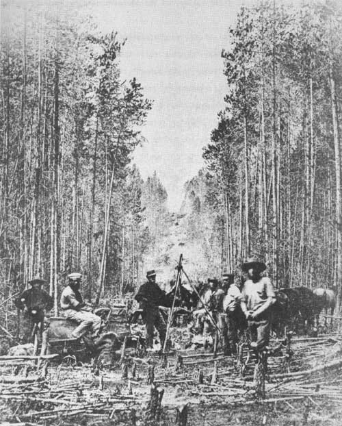
Crew surveying, clearing, and marking the 49th parallel, the International Boundary between Canada and the United Sates, date unknown. (NPS-PNR photo file) |
With the completion of these reconnaissances, Custer's detailed account comes to a close. He had traveled more than three hundred miles and "reconnoitered and made suitable to be mapped" more than one thousand square miles using three compasses, a barometer, and a sextant. He conceded that some of the descriptions and observations included in the report were not of a topographical nature. However, Custer defended his actions by claiming to be the sole visitor to these parts, and had he acted differently, "a great deal of instruction and valuable information would have been lost." [67] After Custer's historic expeditions, the record reveals that no Euro-Americans penetrated the North Cascades for another dozen years.
|
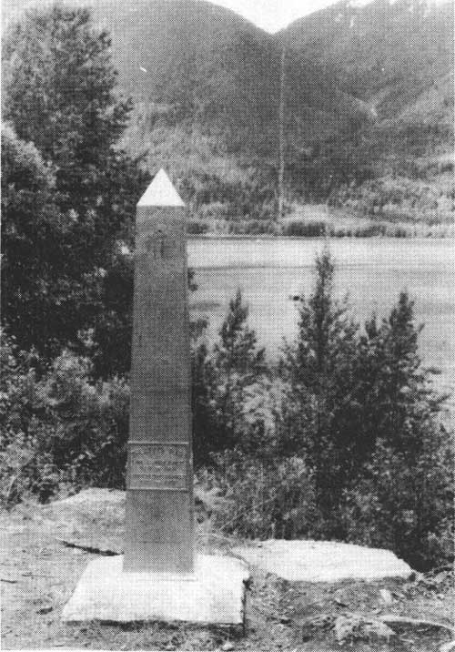
| International Boundary marker at Hozomeen, Washington. Note swath through dense forest following surveyed boundary on mountain slope behind monument. (Photo by G. Luxenberg, NPS, 1984) |
Despite Custer's remarkable efforts at exploring and surveying the area of the 49th parallel, disputes arose concerning the locations of boundary markers. In an effort to resolve these ambiguous boundary points, Britain and the United States resurveyed the line in 1901. In 1908 a treaty was signed calling for the complete resurvey and remarking of the boundary. In addition to the replacement of monuments, seventeen of which are still intact along the national park's northern boundary, the 1908 agreement called for vistas to be cut through the entire forested country along the area near the markers as had been practiced previously. This path of clear-cut vegetation through the North Cascades remains today and is maintained periodically. It is a strong cultural statement on a landscape that otherwise remains a wilderness. [68]
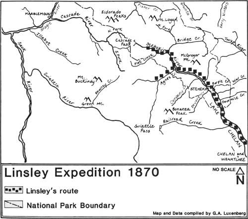
Daniel Chapman Linsley (1870)
The first white explorer to traverse the length of Lake Chelan and enter today's park was Daniel Chapman Linsley, an employee of the Northern Pacific Railroad. [69] Linsley and John A. Tennant alternated between canoes and foot travel in search of a railroad route across the Cascades. Linsley set out from a Wenatchee trading post in July with Tennant and four Indian guides. Traveling up the Columbia River by canoe the party reached the outlet of Lake Chelan in three days. [70] After a three mile portage from the river, the party started up the lake, the Indians in canoes and Linsley and Tennant on foot. They camped near present-day Manson, on the north shore about ten miles from the foot of the lake.
Four days later the party reached the head of the lake. They entered the mouth of the Stehekin River (which they erroneously called the Chelan River) and proceeded upstream. The party camped about seven miles farther upstream, possibly at or near present-day Company Creek. [71] On July 20 the group continued upriver until reaching Agnes Creek, which they believed to be the uppermost navigable point on the river.
Just above this point the stream [Stehekin River] divides into three branches. The largest [Stehekin River] comes from the N.W. and heads near the upper tributaries [Cascade River] which can be nearly reached by canoes from the west. [72]
Linsley had little hope of finding a favorable route via the Stehekin River but was nevertheless compelled to explore every possible route. Consequently, he divided the small party in two, sending Tennant and two Indians up the Stehekin River while he and the remaining two Indians explored Agnes Creek. [73]
|
| Linsley Expedition 1870 |
After two days of struggling with the difficult terrain along Agnes Creek and inclement weather, Linsley returned to the Stehekin River and rendezvoused with Tennant about four miles downstream. Tennant's route was no more promising than his own and Linsley wrote, "He [Tennant] found the route up the west Fork [Stehekin River] utterly impracticable and . . . returned without going to the summit [Cascade Pass]." [74] Linsley concluded from his exploration of the area that a railroad could be built from the mouth of the Skagit River to the Columbia River by way of Lake Chelan, but that it would be much costlier than the preferred southern route examined earlier.
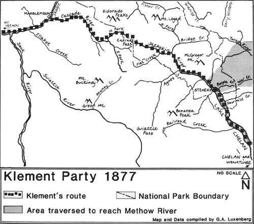
Klement Party (1877)
The next expedition to penetrate the wilds of the North Cascades came in 1877. A party of prospectors, consisting of Otto Klement, Jack Rowley, Frank Scott, Charles Van Pressentin, John Duncan, John Sutter and one or two Indian guides traveled up the Skagit River in shovel-nose canoes in hopes of making their way east to the Methow River valley, where gold had been discovered. These men made the second confirmed crossing of Cascade Pass by Euro-Americans (Alexander Ross being the first in 1814). [75] No contemporary account of this specific journey appears to exist; however, Otto Klement vividly recounted the journey years later in his "Early Skagit Recollections" written in 1935.
According to Klement, the seven-man party traveled two days up the Skagit River before reaching its confluence with the Cascade River. At this point they began their eastward hike over the mountains. With sixty-pound packs on their backs and rifles in place, the party set out along an old Indian trail:
After five days of weary plodding we reached the summit of the Cascade River pass, and a more enchanting scene our eyes had never before gazed upon. Mountains piled upon mountains stretching away in every direction, presenting the most startling scene imaginable. A silence pervaded the scene that was oppressive, except on occasion when an avalanche of thousands of tons of ice, snow and rocks, breaking from their anchorage in a higher altitude, poured down the mountain side into some dark invisible cavern below. [76]
After spending the night on the mountain summit the group made their descent the next day following an Indian trail. This trail led them to a point overlooking Doubtful Lake, which Klement named Spirit Lake:
This pool figures among the most picturesque scenes we had encountered thus far. The water of the lake was a deep indigo blue. On the south side a perpendicular wall arose from the water's edge to a height of hundreds of feet with a high mountain above it [Sahale or Boston Peak]. . . [77]
|
| Klement Party 1877 |
As they continued their descent into the Stehekin valley, Klement noted that "the scene here had undergone a marked transformation." The vegetation on the west slope of the mountains, primarily fir, hemlock, and cedar, had been replaced by "scattering pine trees." [78] By the following day the party had reached the outlet of the Stehekin River. The party spent the next two days recreating and fishing in Lake Chelan while Klement and fellow traveler Joe Seaam sought to replenish their provisions, traveling downlake in canoes found at the head of the lake. Supposedly these canoes were owned and kept hidden by Skagit Indians who frequently crossed Cascade Pass as a trade route. [79] Upon Klement's return the group of prospectors worked their way to the unnamed tributary of the Methow River within two days. Not finding an ounce of gold, the men returned, retracing their steps over Cascade Pass and down the Cascade River. [80]
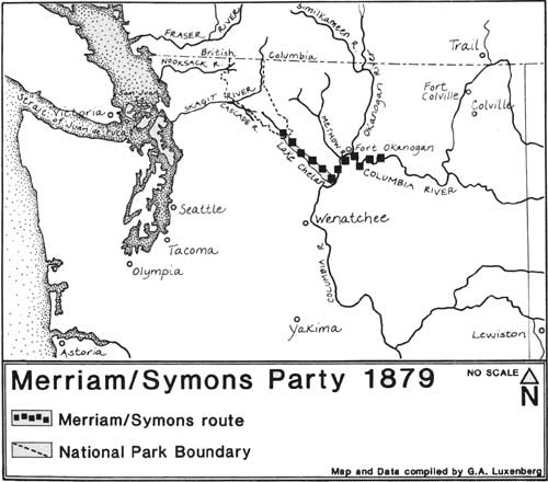
Merriam/Symons Party (1879)
Two years after this private group of gold-seekers passed through the North Cascades, the United States Government revived its interest in the area. Indian unrest elsewhere in the territory during the 1870s prompted the government to establish several temporary and permanent military forts as a precautionary measure. In 1879, Lieutenant Colonel Henry Clay Merriam and Lieutenant Thomas Williams Symons were sent to establish one such outpost on the east side of the Cascades.
With orders in hand, Merriam and Symons met in September of that year at the confluence of Foster's Creek and the Columbia River, near Fort Okanogan. They immediately set out down the Columbia in search of a suitable site for the new fort. After examining both sides of the river they decided the best site was at the outlet of Lake Chelan. A good supply of timber existed there and "the purest water is at hand and available for every purpose." [81] Symons recorded his impressions of Lake Chelan eloquently:
Lake Chelan is a wonderfully beautiful sheet of water, about 60 miles long and from 1 to 5 miles wide. It seems to be and is in fact a dammed-up mountain canon of the most rugged and pronounced description. The water is of diamond-like clearness and yet in places no sight can penetrate to the bottom of its liquid depths. It is supplied from mountain springs and from the melting snows of the mass of snow-capped mountains lying about Mount Baker [Symons was incorrect this latter detail]. [82]
Both Merriam and Symons navigated up the lake in a dug-out canoe approximately 24 miles but did not enter today's park on this particular trip.
|
| Merriam/Symons Party 1879 |
The following year, in the spring of 1880, Colonel Merriam relocated his troops from their temporary home at Foster's Creek to the new campsite at Lake Chelan. "Camp Chelan was established just where the lake narrows into the creek [Chelan River], on a beautiful bunch-grass-covered plateau on the north bank, stretching back about a mile to the rocky and timbered hills." [83] The troops "carried on with vigor and rapidity," building a sawmill and fortification.
That summer Merriam took the time to explore the lake further, traveling its entire length by canoe. Merriam's general observations were recorded by Symons:
Colonel Merriam afterward went further up the lake, and says that the timber becomes better and better as the lake is ascended, and cedar is found [sic] about the head of it, which region he describes as being wonderfully grand. At the extreme upper end he found solid vertical walls of rock and on these, several hundred feet above the water's edge, were a large number of hieroglyphics written in a horizontal line, evidently by people in boats when the waters were at this higher level. [84]
The site, however, had far too many drawbacks, and within one year the army decided to abandon Camp Chelan. By October of 1880 Merriam had orders to reestablish a new post at the mouth of the Spokane River. The post became known as Fort Spokane and it served as a military fort for sixteen years until abandoned by the government in 1900. [85]
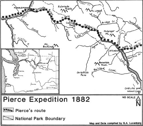
Pierce Expedition (1882)
The Army's interest in this region of Washington Territory was sustained after Lieutenant Symons completed another assigned reconnaissance of the Columbia River in 1881. Additional exploration teams were organized by the Army to find efficient routes of transportation and communication. A minor Indian uprising which occurred earlier at the confluence of the Baker and Skagit Rivers further convinced the Army of the value and necessity of a viable route through the North Cascades. As a result, in 1882 Lieutenant Henry Hubbard Pierce was assigned to explore deep into today's park.
Traveling with a party comprised of Assistant Surgeon George F. Wilson, Topographical Assistant Alfred Downing, First Lieutenant George B. Backus, Jr. (mentioned previously for exploring an area outside park boundaries), guide Joe LaFleur, two sergeants, four privates, a musician, a packer, fourteen mules, and fifteen horses, Pierce departed from Fort Colville on the first of August. [86] He was directed to cross the Okanogan and Methow Rivers and to proceed to the head of Lake Chelan:
Thence, if practicable . . . cross the mountains to Skagit River, pass down the river to Puget Sound. . .The principal object of [the] reconnaissance is to obtain such knowledge of the country and its occupants as may be valuable at present or in the future to the military service. [87]
Following the Methow River to the Twisp River, Pierce's party continued up that drainage along a well-traveled Indian path to War Creek. [88] Within seventeen miles the Pierce party reached the summit of a high divide, and, two days later, they had ascended War Creek Pass. The party soon passed "a small, round lake of melted snow to the left" (Lake Juanita), and within a mile's hike they reached "the pass that overlooks the head of Lake Chelan, known today as Purple Pass. [89]
As I gazed westward from a height of 6850 feet above the sea, and 5800 feet above the lake, a scene of remarkable grandeur was presented. To the south and west, were the rugged peaks of the Cascade Mountains covered with everlasting snow. At our feet, reposed [Lake] Chelan, in color like an artificial lake of thick plate-glass; While the Pierce River [the Stehekin River] brought its clay-tinted waters with many a winding down the narrow canyon that opened to the north [west]. No painter could place the view on canvas, and be believed. [90]
Leaving three men to serve as herders at the base camp established near Lake Juanita, Pierce and the others proceeded to descend Purple Pass. His account of this tiring hike is applicable today, one century later:
We began the wearisome descent of over three hours to Lake Chelan by a zigzag path along the back of a narrow, rugged spur [between Purple Creek and Hazard Creek]. After 9 miles, knee deep in dust, like ashes, filled with sharp fragments of rock, and constantly threatened by boulders tumbling from above, the almost perpendicular slope was accomplished. Reaching the canyon bottom, camp was made . . . on a sand-bar one mile from the mouth of Pierce River [Stehekin River]. [91]
|
| Pierce Expedition 1882 |
Pierce found the Stehekin River valley to be "a dense jungle of cottonwoods, firs, and underbrush, with frequent lagoons covered by an almost tropical growth of rush-grass, ferns, and other marshy vegetation. . ." [92] The party followed "a most imperfect trail" a distance, reaching Little Boulder Creek the next morning. Within one and a half miles Pierce passed Boulder and Rainbow Creeks noticing Rainbow Falls, "a sheer unbroken fall of 300 feet [which] called forth expressions of admiration." [93] Mountain goats and "lusty trout" were also observed.
After a day's respite from the tedium of hiking, the party continued upriver following a trail along the river's north bank which was "quite indistinct." Fourteen miles upriver the group established camp at the confluence of Bridge Creek (which Pierce named Backus Creek) and the Stehekin River (Pierce named the upper Stehekin River Symon's Fork). The following morning they continued upstream, fording Bridge Creek and following "a wretched foot-path" until they stopped to set up camp near present-day Basin Creek. [94] From here the conditions of the chosen route grew worse. Pierce and Downing moved ahead of the packtrain and began the ascent to Cascade Pass. Pierce wrote, "The tiresome zigzag trail seemed interminable." [95] Pierce and Downing persevered, however, and reached the summit without mishap.
Shortly thereafter, Backus and Wilson arrived, followed by LaFleur and the packer. The latter two reported it impossible to get the packtrain up the steep slope in the sleet that was falling, and Pierce felt obliged to send the supply horses back to Fort Colville. While these arrangements were being made, Backus examined the region, reporting that a small grassy prairie lay close ahead, but beyond that, "a precarious, if not wholly impracticable path" led down the mountain's western slope. [96]
The morning of August 26 did not bring improved conditions. All but one of the party wanted to retreat, but Pierce decided to continue westward. The descent of the west slope began the following day and Pierce noted that Cascade Pass
. . . is low and comparatively easy of approach from the east, but westward the descent is at first rapid and precarious. . . the path wound its uncertain way for three miles through an entangled growth of trailing alders, over seven feet high; emerging from which, we came upon the margin of a creek, in and out of whose waters, the footway led us blindly for a considerable distance. [97]
This creek is believed to be the North Fork of the Cascade River. Continuing down the drainage Pierce noted that the existing Indian trail was "exceedingly serpentine and difficult to meander in all its countless bearings," and the party frequently climbed adjacent slopes to avoid dense undergrowth. [98] After several days of hiking Pierce sensed he was near the confluence of the Cascade and Skagit Rivers and sent Backus and LaFleur ahead to locate Indians willing to lead the entire exploring party down the Skagit River to Puget Sound. [99] Pierce bartered the party's three government horses for a canoe ride downriver to Mount Vernon, where the party could obtain a steamboat to Puget Sound. After an exhilarating journey down the Skagit in swiftly gliding canoes, Pierce was motivated to write, "The Skagit is a beautiful stream, often reminding the traveler of some charming tree-fringed river in New England." [100] By this point the Pierce expedition had long since left the boundary of today's national park. Reaching Sterling by sundown, "a mere logging-camp" but a paradise just the same, the ravenous men ate bountiful suppers before retiring amidst the 109 stumps of the "town" (Sterling no longer exists).
Upon reaching Mount Vernon, Lieutenant Pierce evaluated his successful but arduous reconnaissance. He had hiked 295 miles of territory adding "to a correct understanding of the geography of the country, and per chance attract attention to fertile regions and pleasant landscapes, hitherto unknown." [101] Pierce concluded that the route from Fort Colville to Puget Sound could in no way be recommended as a transportation route. Furthermore, he believed that the mountain range itself was a great enough physical barrier to prevent the eastern and coastal Indian tribes from ever becoming allies. Based upon the findings of the Pierce expedition, a military road through this section of the North Cascades was no longer seriously considered.
Pierce's lengthy report with its accompanying map was received at the Army Headquarters in Washington, D.C., on December 13, 1882. After perusing Pierce's work General William T. Sherman wrote:
. . . little is known of the Region of Country between the Upper Columbia and Pugets Sound. Further Explorations will be made, and publication of the information gained should be made, as it is to the national interest that the timber and minerals of that Region should be brought within the reach of the Emigrants who will throng to Oregon and Washington Territory as soon as the Northern Pacific Railroad is completed. [102]
Robertson/Rodman Expeditions (1883)
True to its word, the Army solicited First Lieutenant Samuel Churchill Robertson to continue the government's exploratory efforts. In June 1883, an army party led by Robertson explored the length of Lake Chelan to the mouth of the Stehekin River. This reconnaissance was undertaken because of discrepancies in the information recorded by Colonel Merriam and Lieutenant Pierce. Robertson's party clarified the dispute concerning the location of the head of Lake Chelan. Although Robertson's report was known to be a "very able one," no written account of his expedition has yet been located. [103]
In August that same year, Second Lieutenant Samuel Rodman, Jr., was assigned to explore the upper Methow River. Rodman ascended the Twisp River and War Creek, essentially following Pierce's route up to War Creek Pass and Purple Pass. [104] He too descended to Lake Chelan, continuing on to its upper end, describing his observations:
A short distance up the lake the scenery rapidly changes, and presents a beautiful aspect. Huge frowning mountains arise, covered with pines whose trunks almost lie flat against the steep sides. Nature has given to this place all the delights of beauty and grandeur. [105]
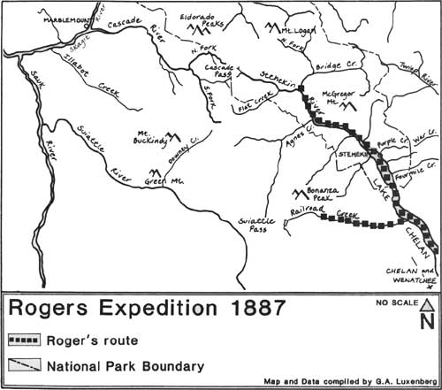
Rogers Expedition (1887)
The Army's final exploration effort in this area of the North Cascades was the Backus-Goethals expedition of 1883. They explored the eastern slope, reconnoitering the upper Twisp and Methow Rivers in late summer, but probably did not pass into today's park. Although none of these military reconnaissances was successful in mapping a feasible transportation route through the mountains, the extensive data collected served to expose a wealth of geographical information.
|
| Rogers Expedition 1887 |
The Great Northern Railroad fielded a reconnaissance party in the summer of 1887. Under the employ of James J. Hill, the party surveyed the upper Lake Chelan region in search of a railroad route through the mountains. The party, led by Albert Bowman Rogers had orders to locate a feasible route to Puget Sound via the Skagit River. Hill was adamant about building his rail line along the Skagit River and sent Rogers exploring numerous routes in the Cascades hoping one would lead to the Skagit drainage. Rogers kept a diary recording his exploration efforts for Hill. He traveled with his nephew Jack (Julian) G. Rogers, a man named Al, and a Lake Chelan settler, W.L. Sanders. [106]
Despite warnings from local residents and Indians that they were "a month or 6 weeks too early to cross the mountains" because of late snow cover, the four-man party set out from Wenatchee on July 6, 1887. [107] By July 9, the party had reached the mouth of Railroad Creek where they established a base camp. For the next six days Rogers and his companions examined the Railroad Creek drainage, and, finding no feasible route, returned to their camp. On July 15 the party moved on to the head of the lake and up a poorly defined trail along the Stehekin River as far as Bridge Creek. [108]
After climbing an unknown peak to view his surroundings, merely recording that the Sauk River, Bridge Creek forks (North Fork and main branch) and "mountain peaks" could be seen, Rogers retreated downvalley, returning to the head of the lake and to Chelan Rogers completed his search for a feasible railroad route through the North Cascades with a journey to the divide via the Skagit and Sauk Rivers (south of today's park). He noted in a letter addressed to Hill dated October 7, 1887:
This route leads wt [west?] to the Indian and Ward's passes-(which are only 2 miles apart)-and is the only route connecting the Skagit with the Wenatchee [River]. Besides being much longer it is no so favorable as the route via the Skykomish [which Rogers explored earlier]. .. .The avalanches on the western slope are fearful. [109]
Once again, all hope faded for a railroad route through the North Cascades.
ROAD-BUILDING SURVEYS IN THE NORTH
CASCADES
The last major expeditions to enter the North Cascades in the nineteenth century were parties of surveyors in search of a route for a "Cascade State Wagon Road." During 1893 and 1895 survey teams authorized by the state government made no less than six attempts to locate such a route. The intent was to link the eastern and western portions of the state, thus enhancing economic growth and development:
Aside from the advantage to cattlemen and to the general traveling public in having a road across the Cascade Mountains, it is of the greatest interest to miners. [110]
Taken as a whole the State Road will be of great advantage not only to the cattle, farming and mining industries but it will be of great value also to the state at large as a continuous highway for the movement of troops in case of necessity, and particularly in the protection of the northern frontier. [111]
One of the last attempts to locate a route through the North Cascades was actually a railroad survey conducted in 1900 led by J.J. Cryderman. Despite Cryderman's efforts no railroad line was built.
By the beginning of the twentieth century the North Cascades had been explored from north to south and east to west. The land that is today a national park was no longer a mysterious wilderness of rocks, forests, waterfalls, and glaciers. Maps and first-hand accounts had been published, exposing the territory to the general public. Miners and settlers had long since arrived, struggling to make a living from the rugged land. In the next chapter we'll discuss the settlers who came to make the North Cascades their home.
In 1893 a Cascade State Road Commission was created, and the State legislature appropriated $20,000 toward the goal of the:
Establishment of a state road through the Cascade Mountains via a pass north of Mt. Baker, to connect eastern and western Washington, (commencing) . . . where Glacier Creek empties into the North Fork of the Nooksack, and running thence by the best practical route via pass north of Mt. Baker to a point on the Columbia River opposite the town of Marcus, Stevens County. [112]
Official cruising began that same year. Under the leadership of Banning Austin and R.M. Lyle, a small party of men set out from Whatcom (Bellingham today) to reconnoiter the west end of the proposed wagon road. Despite the dubious nature and inaccuracies of Austin's report, the party did locate two major passes: the pass over the divide that links Mt. Baker and Mt. Shuksan (named Austin Pass today after the surveyor); and another, named Hannegan Pass, located west of the Chilliwack River drainage and commemorating the chairman of the road commission. [113]
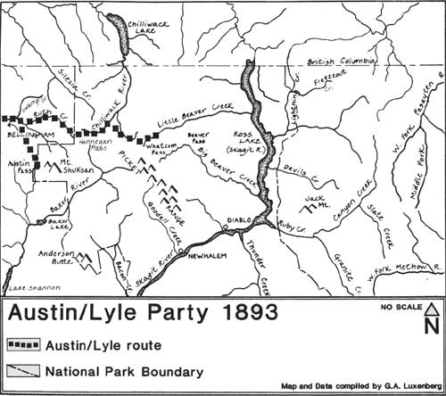
|
| Austin/Lyle Party 1893 |
Austin discovered and recorded what appeared to be a feasible route over the northern Cascade range. His route led him to the Chilliwack River valley and Whatcom Pass, less than 20 miles from the Skagit River. Nevertheless, the route was shunned by the Commission and no road was ever constructed over Hannegan Pass to the Skagit River and beyond to the eastern portion of the state.
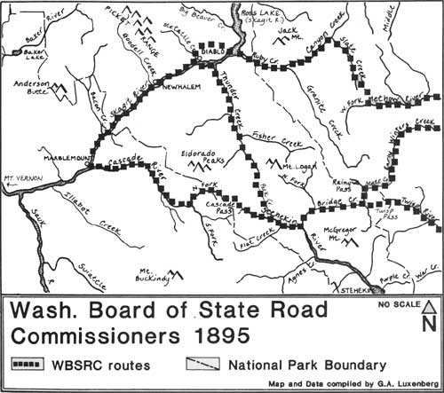
Efforts for an overland route continued, and in 1895 a new commission was created. The Washington Board of State Road Commissioners was appointed under an Act of the State Legislature on March 22, 1895 to survey four different routes through the North Cascades. These routes would take the surveyors through the mountains via Slate Creek, the North Fork of Thunder Creek (Park Creek Pass), Cascade Pass, and Rainy Pass. [114] All four routes brought the surveyors well into today's national park.
Between July 22 and September 11, 1895, engineer Bert Huntoon and commissioners E.M Wilson, R.O. Welts, and J. Howard Watson traversed approximately 500 miles of the North Cascades. Whenever possible the group followed trails established earlier by Indians and miners. Still, they were often forced to open new trails along most of the Rainy Pass route and "travel without a trail over a part of the Thunder Creek route." [115] Because of these conditions and the speed of the pack animals, progress was slow: on good trails they covered upwards of 18 to 20 miles a day, on poor trails or in places where extensive survey work was required they made as little as three miles in a day. Barometric altitudes and profiles were recorded and tabled along the way, as well as elevations of six mountain passes and distances between major points. A map of the country was compiled with natural features delineated including all streams and their true courses, as well as the names and locations of settlers' cabins encountered along the way: "This map is of inestimable value to the state, as all of the present government and state maps of this section are woefully erroneous and misleading." [116]
The four-man group departed from Marblemount where they had obtained horses and "pack outfits" for their trip, examining the Slate Creek route first. Their observations of the upper Skagit River region in 1895 are a valuable source of information today:
The trail to Slate Creek from Marble Mount runs for seventeen miles through the forest and along the Skagit River, over a fairly-level country, but after the first four miles some rock is found. In the tenth mile the "Devil's Dream" (a trail made in front of a rock wall by rude bridges above the Skagit River to avoid rock work) is reached. The trail then runs along level bottom land mostly until the end of the seventeenth mile is reached. The eighteenth mile begins with a rock point, where the Skagit Canyon and rapids are first encountered. The trail here passes along a very high rock bluff, and the work is heavy for the first mile, but some lighter in the nineteenth mile, which brings us to the site of the old goat trail bridge, which washed away in the floods of 1894. At this point the celebrated "Goat Trail" begun [sic] and extended to Cedar Bar [Davis Family Homestead location], a distance of 2-1/2 miles; and, up to within a few days of our arrival, the only mode of travel over it was on foot, using a ladder to scale the most difficult points. The volunteer work [by miners] done in the spring of 1895 by blasting half tunnels through perpendicular cliffs and constructing rude bridges across chasms made it passable for small horses, but still the grades, in places, are excessive, and the bridges and trail dangerous and difficult for even the lightest pony traffic. . . . It is a picturesque place and rugged enough for the most ardent mountain climber. [117]
From Stetattle Creek, near Cedar Bar, the party continued upriver about three miles, coming to the junction of the "old Thunder Creek bridge." The Thunder Creek route branched off at this point. Continuing up the main river trail, the party climbed around Sourdough Mountain noting: "this climb being necessary as the Skagit River here runs in a rock canyon where road building is impossible without extraordinary expense. . . ." [118] The surveyors determined that the only route for a wagon road in this area would require dropping down to the Skagit River at the mouth of Ruby Creek after crossing Sourdough Mountain.
At the junction of the Methow and Twisp Rivers the party embarked on the second leg of their assignment, which would return them to Marblemount via Cascade Pass. Following the Methow River to the confluence of the "Twitsp" River, the men pushed on, crossing the latter to the north side and proceeding along an established trail. After crossing Twisp Pass the party dropped down to the confluence of Bridge Creek and the Stehekin River.
Going up the Stehekin River valley there is an easy water grade on bottom land for seven miles . . . From Pershall's [an early Stehekin valley settler and miner] cabin (the seven mile point) there are steep side-hills, with slide rock for about one mile, to the head of the Stehekin, when a stiff climb is made to the pass 2-1/2 miles, (or three miles by the engineer's estimate) of 2,400 feet . . . . Cascade Pass has an icy appearance even in summer as the Glaciers hug it close and snow remains in the shady side of the pass generally all the summer. [119]
|
| Washington Board of State Road Commissioners 1895 |
From Cascade Pass the surveyors proceeded down the western slope of the ridge, noting that "the old trail is down a very steep slope and decidedly uninviting, no perceptible work even [sic] having been done on it." [120] Within two and a half miles the party reached Gilbert Landre's cabin on the Cascade River. Landre was an early settler and miner in the region who ran a roadhouse in the backcountry. From Landre's cabin, the group followed a good, mostly level trail to Marblemount, a distance of about 20 miles.
The next excursion was the Thunder Creek route leading the surveyors over Park Creek Pass. Retracing their steps along the Skagit River and the Goat Trail to where Thunder Creek joins the Skagit River, the party noted:
Thunder Creek here comes through a rocky gorge, a rare picture of beauty, but expensive from the road builders point of view. It empties into the Skagit River which here runs through a rocky canyon, and unless one stands directly in front of Thunder Creek its place of entrance into the river is hidden by the close towering walls. [121]
Continuing up Thunder Creek the surveyors traveled along an established miner's trail noting "the route is easy, the present narrow trail being fairly well graded, but needing a great deal of work." [122] At the ten-mile point a "tree" bridge redirected the trail across the creek where it then continued up toward Thunder Creek Pass (Park Creek Pass today) traversing a steep slope on which a trail had never been built. From the pass the party descended to Bridge Creek. Having already traversed the route along Bridge Creek to Twisp Pass, the men retraced their steps and returned to Marblemount.
The last route led the surveyors along the previously traveled Slate Creek route to Granite Creek. Beginning at Marblemount and traveling to Ruby Creek the party crossed Rainy Pass, "along which a trail had never been even blazed," and then proceeded down Bridge Creek to State Creek, up State Creek to Washington Pass, and then down Early Winters Creek to the Methow River valley. [123] Except for the initial part of the journey this route led the surveyors outside the boundaries of today's park.
The commissioners published their findings in a report in 1896. Photographs were taken on the four routes depicting scenes along the Skagit River and Ruby Creek. The "Approach to Devil's Corner" (the footbridge visible and accessible today) and Devil's Corner itself (not accessible today) were also photographed. Apparently impressed by the ingenuity of miners, the commissioners elaborated on their efforts:
[the] Goat trail is truly picturesque and shows the energy displayed by the active interests of the Slate Creek mining district in opening a way of ingress and egress. There is considerable of this [photo depicting a trail beneath a rock overhang] which is built in the most available places without regard to grades and the roof just high enough for pack horses to pass under safely. [124]
After careful consideration of all four routes, the Board determined: "the route up the Twitsp [sic] River, over Twitsp Pass, down Bridge Creek, up the Stehekin River, over Cascade. . . Pass and down the Cascade River the shortest and the most feasible and practicable." [125]
Road work did actually commence as a result of the 1895 survey. In the spring of 1896, and with a road width of forty feet established, foremen and laborers were hired to begin the work. On the east side of the mountains, Stehekin valley settler Merritt Field contracted with the state to operate "the boarding houses [for laborers] at the two central camps on lower Bridge Creek and Stehekin, doing all of the packing and moving of these two camp outfits, as desired, free of cost to the State." [126] The road crew was able to construct a road from Stehekin to Bridge Creek, running past Coon Lake (a later road, a mine-to-market road, was built from Bridge Creek to Horseshoe Basin in the 1940s). The "road" to Bridge Creek, however, was not without faults: logs lay across it and large rocks were never removed. Consequently, the road was not used. Today, portions of this route have become a hiking trail within the national park. Some valley residents contend the early road can still be followed in its entirety, despite the vegetation that has grown over it.
In 1896, a road on the west side was built twelve miles up the Cascade River but it too was never completed across Cascade Pass. Ironically, the road that would eventually traverse the mountains followed a route that the commissioners had determined to be the longest and "the most expensive part of the Slate Creek route." [127] The North Cross State Highway, also known as the North Cascades Highway, was completed 77 years after these men surveyed the region — more than one and one half centuries after the first recorded crossing of the North Cascades was accomplished by a Euro-American.
One of the last attempts to locate a route through the North Cascades was actually a railroad survey conducted in 1900. A party for the Bellingham Bay and British Columbia Railroad (B.B. & B.C.R.R.) completed a reconnaissance over Hannegan Pass and east to and over Whatcom Pass. This party essentially retraced the route followed by the Austin-Lyle party seven years earlier. Between August 23 and September 7, J.J. Cryderman led six men from Whatcom, mapping, photographing, and recording his observations of both natural and cultural features and activities in the region.
Traveling by railroad and then wagon road, the men reached the end of the road at Shuksan, a small mining town along the north fork of the Nooksack River. [128] Continuing with horses, the party traveled east, heading up and over Hannegan Pass and into today's park. Cryderman noted that:
On the east side of Hannegan Pass there is considerable timber . . . Indications of minerals are good mostly as on the west side of the Pass, gold and copper. However owing to the present inaccessible location of the country, few [mineral] locations have been made and practically no work has been done. In the matter of reaching the country, there is now a fair county road to Shuksan, then a fair pack trail, though in need of repair, 8-1/2 miles up Ruth Creek or to the end of the old State Trail and from the latter point a poor horse trail over Hannegan Pass and down the Chilliwhack [sic] to the mouth of Copper Creek. . . . Horses have been taken from here to Whatcom Pass and to the mouth of Indian Creek, but it was when the River was low and the bed of the Chilliwhack was used for much of the distance. From Whatcom Pass there is no trail until within two miles of the mouth of Big Beaver creek, where there is one from McMillan's ranch [early homestead] on the Skagit River. [129]
After the party completed their reconnaissance and returned to Whatcom, Cryderman wrote a final report for J.J. Donovan, General Superintendent of the B.B. & B.C.R.R. Cryderman believed that the route he followed was the best and only feasible route through these mountains. He added that his work verified the 1893 findings of the State Road Commission and that should a road be built following this proposed route, it would be the most scenic one within the United States:
From the time [the road] reached the head of Ruth Creek to Beaver Pass . . . there is a succession of unequaled views. There are still mountain goats and numerous bear in the mountains and fine fishing in the creeks on the Chilliwhack [sic] side and abundant picturesque peaks for the mountain climber to struggle with. We saw enormous quantities of huckleberries of extra size and flavor and on Big Beaver where swamps are marked on the map, is a series of cranberry marshes, the berries being the high bush variety and the swamps being red with fruit. [130]
Despite Cryderman's efforts no railroad line was built. By the beginning of the twentieth century the North Cascades had been explored from north to south and east to west. The land that is today a national park was no longer a mysterious wilderness of rocks, forests, waterfalls, and glaciers. Maps and first-hand accounts had been published, exposing the territory to the general public. Miners and settlers had long since arrived, struggling to make a living from the rugged land.
CONCLUSIONS AND RECOMMENDATIONS
The Northern Cascades were explored by Euro-Americans for more than a hundred years. Among the first were traders and trappers using Indian trails and tracking the wilderness for resources. They were soon followed by a variety of individual adventurers and government explorers who mapped, charted, and described the remote region. Significant among this latter group was the survey party marking the 49th parallel and boundary between the United States and Canada. This journey, perhaps more than any other, left behind a rich collection of early maps, sketches, and verbal descriptions of the area. Furthermore, the need and subsequent search for a northern passage through the Cascade Range maintained interest in the area well into the twentieth century. Because of this interest, maps of the region were continually updated and corrected. Today, many routes followed by explorers and surveyors are still used by backcountry visitors traversing the park.
Because explorations and surveys in the North Cascades were transitory in nature, no tangible structures other than the line of monuments and cairns delineating the boundary between Canada and the United States remain. Twenty-three and one half miles of this boundary line mark the northern edge of the national park. Although difficult to reach, there are two points where a hiker can view the forty-foot-wide swath of land marking the boundary: in the northwest section of the park the Chilliwack River trail can be followed to monument no. 51 where the river crosses the 49th parallel (a short hike to the west side of the river leads to monument no. 50); in the northeast section of the park, monument no. 72 stands along a self-guiding nature trail north of Hozomeen Campground on the east side of Ross Lake. Above the western lakeshore stands monument no. 71.
Exploration is a significant theme within the overall context of the human history of the park and should be interpreted accordingly at visitor centers, in park publications, and interpretive programs.
The following resource is eligible for listing in the National Register of Historic Places within the historic theme identified in this chapter:
INTERNATIONAL BOUNDARY, and associated monuments located within the national park, for its association with nineteenth century efforts to explore, survey, and delineate a northern boundary for the United States. It is also recommended that these monuments be added to the park's List of Classified Structures.
This study recommends that the trail over Cascade Pass be identified in interpretive programs and visitor centers as a significant historic route of passage between the Stehekin River valley and the Skagit River valley for Native Americans and the explorers, surveyors, miners, and, more recently, recreationists, who followed.
| <<< Previous | <<< Contents>>> | Next >>> |
noca/hrs/sec1.htm
Last Updated: 07-Feb-1999