|
NATCHEZ TRACE PARKWAY
Excavations at the Pharr Mounds and the Bear Creek Site |

|
THE SITE AND ITS SETTING
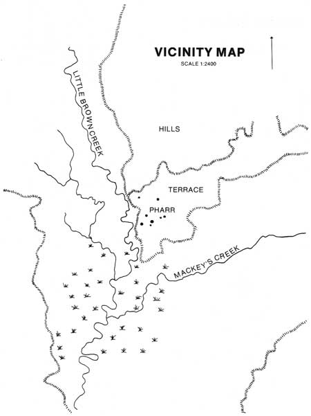
The Pharr Site straddles the Prentiss-Itawamba County line in northeastern Mississippi, approximately 20 air miles northeast of the city of Tupelo. It is located in section 3-B of the Natchez Trace Parkway. The site is named from its location on "Pharr Flats," a broad, gently rolling terrace overlooking the marshy bottomlands at the junction of Little Brown and Mackeys Creeks (fig. 1).
|
| FIGURE 1.—Vicinity Map. (click on image for a PDF version) |
The site lies in the headwaters of the Tombigbee River, on the southwestern fringe of the physiographic region known as the Tennessee River Hills. Locally, the topography is hilly and rugged, but broken frequently by broad, swampy stream bottoms. The upland topsoils are typically thin red loam and the bottoms are covered with rich brown or black sandy loam.
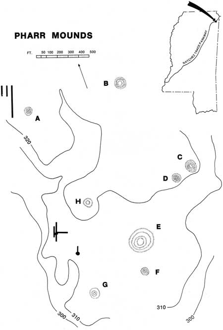
The principal archeological features of the site are eight dome-shaped mounds of varying size. Several of them have been considerably reduced by cultivation. The dimensions of the mounds, designated A through H, are:
| Mound | Width/Length or Diameter (in feet) |
Height (in feet) |
| A | 55 by 65 | 7 |
| B | 105 by 110 | 18 |
| C | 115 in diameter | 18 |
| D | 80 by 95 | 12 |
| E | 165 by 175 | 8 |
| F | 60 in diameter | 8 |
| G | 200 in diameter | 6 |
| H | 110 by 130 | 2 |
A search of the fields around the mounds turned up surface material in significant amounts only along the western side of the site. Flint spalls and chips (there was almost no pottery) were thinly scattered from the foot of the hill north of Mound A along the edge of the terrace to a point roughly 1,000 feet south of Mound G (fig. 2). Heavier concentrations did occur in some spots. One place in particular, an area of rich black soil about 500 feet southwest of Mound H, looked promising as a habitation area. The remainder of the site was virtually barren of surface material.
|
| FIGURE 2.—Pharr Mounds. (click on image for a PDF version) |
There are a number of large pits adjacent to the site which we thought might have been the source of the fill used in the mounds. Observation showed, however, that they were dug into a gravelly soil not found in the mounds. Local residents informed us that the pits had been dug recently to obtain road surfacing material.
| <<< Previous | <<< Contents>>> | Next >>> |
pharr_mounds-bear_creek/sec1-1.htm
Last Updated: 15-May-2008