|
Lake Roosevelt
Administrative History |

|
CHAPTER 2:
The River Becomes a Lake (continued)
Clearing the Land for the Reservoir
Clearing the reservoir area was one of the largest Work Projects Administration (WPA) projects ever undertaken. The clearing project was completed in December 1941; it took just over three years from start to finish. The WPA furnished all the labor, built the camps, and operated the mess halls, and Reclamation supplied the equipment and materials. Most of the area cleared lay between the low-water elevation of the Columbia River and its tributaries and elevation 1,290 feet, but clearing was done higher in upper reaches of the reservoir and in areas with landslide potential. Approximately 54,000 acres were cleared, over 11,000 acres grubbed (even the roots were dug up), and thirty-three million board feet of merchantable timber harvested. When the work was completed, the government had spent $4.9 million on labor. [27]
The height of Grand Coulee Dam and the maximum level of the reservoir were determined by the elevation of the Columbia River at the Canadian border. The water level in the lake is not allowed to rise above 1,290 feet; otherwise, it would back water into Canada. In the early 1930s, Reclamation surveyors marked the 1,290-foot high-water line to show the land to be cleared of trees, brush, and other objects that could present hazards to boaters or to the water intakes behind the dam. The clearing procedure varied with elevation. Between 1,250 and 1,290 feet, most combustible or buoyant material was uprooted, pulled, or grubbed for complete removal, then piled and burned (small brush was cut off flush with the ground, and non-combustible material was razed and placed in pits). Between 1,200 and 1,250 feet, stumps were cut no more than six inches above the ground. Between the Columbia River and 1,200 feet, stumps were cut no more than two feet above the ground. Building foundations, walls, and chimneys were razed, and brush less than three feet high was left as it was. [28]
Timber cruising to estimate the amount of merchantable timber was done in the late 1930s. The timber within the reservoir area was logged by WPA crews, skidded to the river, and floated downstream where it was sold to the highest bidder. In 1939, the Lincoln Lumber Company bid $2.25 per thousand board feet for this timber. The company's mill was located at the mouth of the Spokane River, so timber cut downstream ended up being burned or otherwise disposed of. This lumber company's plant close to the river had to be dismantled when the backwaters advanced. The trees in the many peach orchards along the river were uprooted and burned. [29]
Reclamation began surveys for the relocation of railroads and roads in the reservoir area in 1935, and contractors began constructing the realignments that spring. Great Northern Railway branch lines to Nelson, British Columbia, and to Republic, Washington, had to be realigned. Old roads within the reservoir area were kept open as long as possible. Some ninety miles of state highways were reconstructed, under supervision of the state. Reclamation supervised the construction of relocated county roads and then turned them over to the counties. New highway bridges were built. Affected roads on the two reservations totaled approximately thirty-three miles, and the Indian Service did the relocation work on these roads. Old railroad bridges were dismantled and new ones constructed. Public utilities and industrial sites had to be relocated or purchased. The state provided a ferry at the mouth of the Sanpoil River (Keller Ferry), and the private ferry at Gifford-Inchelium continued operation. The old cable ferries had to be replaced by power ferries because of the lack of current in the new reservoir. [30]
Other tasks faced by Reclamation during the years between 1933 and 1942 included widening a section of the Columbia River channel in the Little Dalles area near the Canadian border by removing a rock island down to 1,255 feet along with part of the left river bank. This was done in order to prevent inundating Canadian lands during periods of high floodwaters. A legal case that took several years to settle was the claim by Washington Water Power that backwater from the reservoir caused injury and reduced power output at its Little Falls Power Plant on the Spokane River. [31]
| |
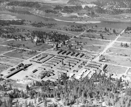
| Camp Kettle, largest of the eight camps built by the WPA to house the men clearing the reservoir site. At the height of its use, more than 1,300 men lived at this camp. Photo courtesy of MSCUA, University of Washington (Grand Coulee Dam 216). | |
The number of WPA workers hired for the clearing project peaked in March 1941 at 2,626. The men stayed in temporary camps of frame buildings or tents set up at various locations along the Columbia River. The five main camps each had barracks, recreation hall, mess hall, dispensary, offices, warehouse, garage, and blacksmith shop. Camp Lincoln was established first, followed by camps Spokane, Detillion, Gerome, Gifford, and Kettle. Camp Kettle was located on the old townsite of Kettle Falls and in 1940 became headquarters for the entire clearing project. Camp Ferry was a floating camp of three barges that held up to eighty men who cleared lands inaccessible to the land crews, and it operated from March 1939 until October 1941. [32]
The clearing crews were supported by over twenty WPA boats and barges, all built by the crews except the Blue Ox, a tug that had been used at Boulder Dam. Tugs and boats hauled Camp Ferry and transported men and equipment to work sites along the river/reservoir. Land equipment included power shovels, Caterpillar tractors, and a fleet of sixty trucks. [33]
| |
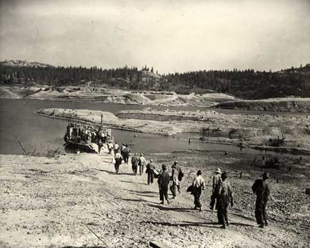
| WPA workers boarding Gerome Ferry to take them to Camp Gerome, on the far side of the river. Note the tree stumps on the land that will be inundated by the reservoir. Photo courtesy of MSCUA, University of Washington (Grand Coulee Dam 5). | |
In April 1941, the government declared the clearing work a national defense project, which intensified the push to complete the work. Contractors built the dam faster than anticipated, and the WPA was hard pressed to complete the clearing on time. The last tree was cut July 19, 1941, near Kettle Falls. The work at Kettle Falls then consisted of grubbing and burning and dismantling camp buildings, but the clearing had not been completed when water began flowing over the site. [34]
On June 1, 1942, people gathered to watch the first trickle of water flow down the spillway face of Grand Coulee Dam. The reservoir was full at the downstream end, but it took another six weeks to reach the 1,290-foot level all the way up the reservoir. [35] The clearing project was done. The still waters of the Columbia River Reservoir - soon to be known as Lake Roosevelt - now lay where the Columbia River had once flowed. The home sites of some three thousand people lay beneath the water.
| |
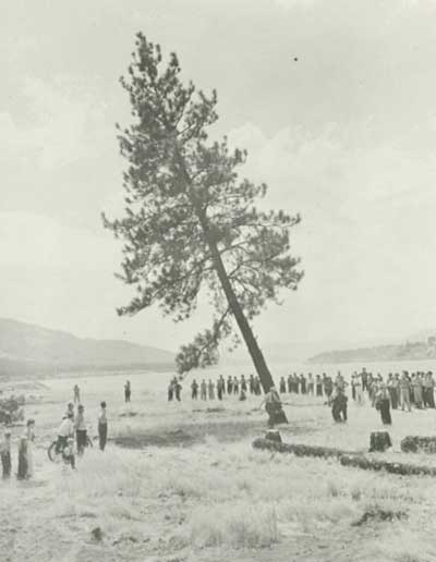
| Bureau of Reclamation Supervising Engineer Frank A. Banks and State WPA Administrator Carl W. Smith felling the symbolic "last tree" in the reservoir area, on the site of old Kettle Falls, July 19, 1941. Photo courtesy of U.S. Bureau of Reclamation, Grand Coulee (USBR Archives 189). | |
| <<< Previous | <<< Contents >>> | Next >>> |
laro/adhi/adhi2b.htm
Last Updated: 22-Apr-2003