|
Lake Roosevelt
Administrative History |

|
INTRODUCTION
For thousands of years, the upper Columbia River sustained the people living within its watershed. Early people established camps and homes along the river, followed in more recent times by others who also built houses and communities along the banks of the wide, flowing river. By 1941, however, the federal government had dammed the river at the north end of Grand Coulee, creating a man-made reservoir named Lake Roosevelt that inundated homes, farms, and businesses and disrupted the lives of many. But government officials also envisioned the new lake's potential to attract visitors and residents for a new purpose — recreation — and National Park Service representatives began to plan for recreational use of the area.
Park Service employees of the 1940s, from people in the field on up to the Director himself, argued the merit of including "national recreational areas" within the National Park System. After considerable hesitation and disagreement, the Park Service determined that Lake Roosevelt was nationally significant, paving the way for it to become a National Recreation Area (NRA). Although Congress never enacted specific authorizing legislation to create the park, it passed generic legislation that gave the Park Service authority at the NRA. In addition, Congress has recognized the unit with line-item appropriations since 1949, and in 1970 it became a unit of the National Park System.
Many challenges face the managers of Lake Roosevelt National Recreation Area. Some result from the boundaries of the park, established in the late 1930s and modified in later years. The U.S. Bureau of Reclamation (Reclamation) acquired all land above the water, which is at 1,290 feet at full pool, up to the "taking line" at the 1,310-foot contour line; this strip is often referred to as the freeboard lands. Because it was often easier and in some cases cheaper simply to purchase entire parcels rather than partial tracts of land, the boundary line for the NRA is irregular and sometimes goes above the 1,310-foot taking line. The width of the shoreline strip administered by the Park Service thus varies from about fifty to several hundred feet, depending on the steepness of the slope.
Lake Roosevelt's shoreline totals more than five hundred miles of cliffs and gentle slopes. Today, the Park Service manages 61 percent of the narrow strip of federal land along the shoreline of Lake Roosevelt and 58 percent of the total water surface area. The Colville Confederated Tribes and the Spokane Tribe of Indians manage most of the remainder of the land and water. Reclamation retains management of the dam, its immediate area, and a few other locations considered necessary for reservoir operations. Management of the reservoir and its resources is complicated by the fact that nine federal agencies, two tribes, four state agencies, six counties, and four cities have interests in various aspects of this essentially linear resource.
| |
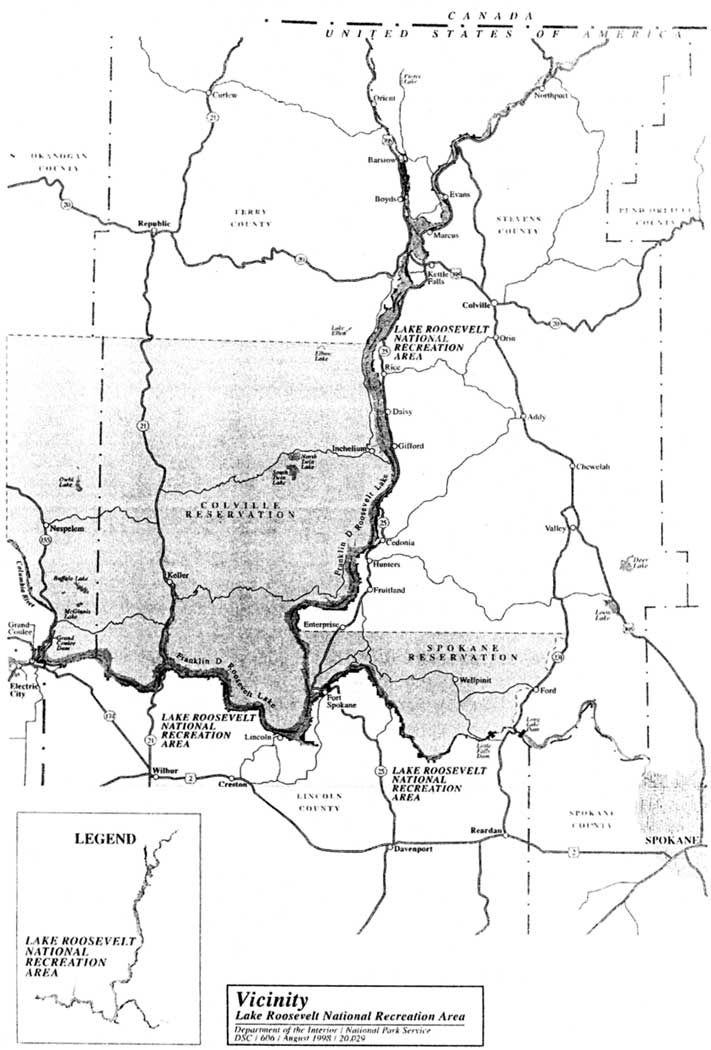
| Map of Lake Roosevelt National Recreation Area. Map courtesy of National Park Service, Lake Roosevelt National Recreation Area. | |
Physical Characteristics of Lake Roosevelt
National Recreation Area
The 1,259-mile Columbia River flows out of Canada and across eastern Washington and then forms the border between Washington and Oregon. The river contributes some 89 percent of the water that flows into Lake Roosevelt today, most of it from the portion of the watershed north of the international boundary. Two major tributaries to Lake Roosevelt - thirty-mile Spokane River and fifteen-mile Kettle River - contribute about 10 percent of the inflow to Lake Roosevelt. The upstream flow is regulated by nine major reservoirs and numerous smaller reservoirs and associated power plants. From its source in British Columbia to its mouth near Astoria, Oregon, the Columbia falls 2,600 feet, thus providing many potential hydropower sites. There is often an observable current in the upper stretches. Of the thirty dams operating on the Columbia River in 1997, Grand Coulee Dam is the largest storage structure. [2] The terms "lake" and "reservoir" are used interchangeably in this report.
|
The general scenic effect of the Reservoir Area
is pastoral rather than spectacular, and a variety of conditions present
ever-changing effects. Vistas tend toward broad landscapes with long
stretches of the reservoir flanked by green rolling hills receding
toward distant mountains.
-- NPS, "Columbia River Reservoir Area," 1944 [1] |
The primary attraction of LARO is the 132-mile-long man-made reservoir behind Grand Coulee Dam, first filled in June 1942. The reservoir's surface area is about 81,000 acres, and its recreation potential in this arid landscape was recognized from the beginning. Little Falls Dam on the Spokane River and the town of Barstow on the Kettle River mark the upper limits of the NRA on those two tributaries. The width varies from about 0.5 to 1.5 miles, and only two ferries and two bridges provide crossings for vehicles. The reservoir is drawn down each winter in varying amounts, generally not more than fifty feet. It is normally near full from July through the summer and fall recreation season, and the water depths range from four hundred feet upstream of the dam to fourteen feet near the international border. The reservoir ends some thirty miles short of the border. The national recreation area includes shoreline along about twenty-five miles of the Spokane River Arm of the lake and about seven miles along the Kettle River Arm.
Lake Roosevelt lies in two strikingly different physiographic provinces: the Columbia Plateau in the southern half of the lake and the Okanogan Highlands in the northern half. In the southern portion, lava flows and Ice Age Flood events have shaped sheer basalt cliffs that often rise nearly one thousand feet above the lake surface. In many locations, the geology is completely different on each side of the lake. Occasional lichen growths on terraced basalt cliffs provide bright splashes of color in brilliant yellows, reds, and greens. The mountains in the northern portion are largely comprised of metamorphic rock and Pleistocene sedimentary features, and limestone cliffs rise above the lake as it narrows near the northern boundary of the NRA.
The Columbia Plateau region covers the area south of the Spokane and Columbia rivers. This area is generally treeless, hot, and arid, and the vegetation is characterized by semi-arid grasslands and sagebrush communities altered by irrigated agricultural lands. The Okanogan Highlands have a more mountainous topography, with a transitional ponderosa pine and Douglas-fir forest community. Ponderosa pine becomes more dense the farther north one goes along the lake. Rocky benches with a growth of scattered ponderosa pine are interrupted by rolling grasslands that in places slope gently towards the water's edge. The bordering hills become steeper to the north, with outcroppings of limestone and granite.
| |
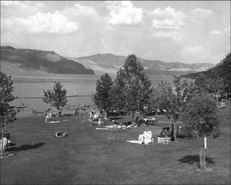
| Spring Canyon beach in the arid Columbia Plateau part of the national recreation area, ca. 1972. Photo courtesy of National Park Service, Lake Roosevelt National Recreation Area ("A Boater's Guide to Franklin D. Roosevelt Lake," draft, ca. 1972). | |
Ground-hugging fog occurs frequently during the winter, and summer lightning storms are common. Precipitation ranges from ten to twenty inches per year and snow cover from four to thirty-six inches, both increasing as one moves northward.
Open-water habitat in the lake and its tributaries supports a variety of aquatic vascular plants. Because of the fluctuating lake levels, perennial marshes along the lakeshore are few; intermittent wetland areas that flood seasonally are more common. They are dominated by reed canary grass.
Wildlife in the Lake Roosevelt area is plentiful. Larger animals include whitetail and mule deer, elk, black bear, and coyote, with smaller mammals represented by porcupine, chipmunks, marmot, beaver, and ground squirrel. Large numbers of ducks, geese, and other waterfowl use the Pacific Flyway, and various resident and migratory birds are seen, including shorebirds and gallinaceous birds such as native grouse, raptors, and passerines. Bald eagles winter and nest in the area, and peregrine falcons have recently been reintroduced. Few if any of the large mammals are permanent residents of the strip of shoreline under Park Service jurisdiction. Non-native fauna includes cattle, horses, ring-necked pheasant, Merriam turkey, chukar partridge, and California quail.

| |
| Clover Leaf Beach in the Okanogan Highlands part of the national recreation area. Photo courtesy of National Park Service, Harpers Ferry Center. | |
Most species of fish that currently inhabit Lake Roosevelt have been introduced except for cutthroat trout and sturgeon. Sport fish include rainbow trout, native whitefish, kokanee, walleye, cutthroat trout, Dolly Varden trout, and largemouth and smallmouth bass. Until at least the 1960s, "scrap fish" were much more abundant than sport fish in Lake Roosevelt; these included such species as carp, squawfish, chub, sucker, shiner, perch, tench, sunfish, and sculpin.
Long-lived Issues
LARO was officially created in 1946, although the National Park Service had taken the lead in managing the area and drawing up plans for recreational sites along the lakeshore since 1941. As soon as the lake started to form, area residents began testing the waters with small watercraft. Because of severe budget limitations, LARO was unable to provide visitor facilities until the early 1950s. The slow development angered some area residents and hindered private development by concessionaires. In 1949, the Park Service first began to propose regulations governing a wide variety of uses of the lake and the surrounding strip of federal land. The controversy that developed over these regulations in the next couple of years left a legacy of resentment and bitterness among some area residents that has been passed down to the younger generations and persists today.
Even more significant has been the major disruption of the traditional lifeways of native peoples of the area. Euroamericans took traditional tribal lands, pushing tribal members onto reservations. The salmon fishery, an extremely important source of nourishment and cultural identity for American Indians of the region, began to diminish in the late 1800s and then abruptly ended in the upstream waters when Grand Coulee Dam was constructed. The Colville Confederated Tribes and the Spokane Tribe of Indians eventually demanded compensation for the loss of their fishery and lands, and in the 1970s they began to take over the management of recreational facilities on their respective reservations. Until then, all recreation facilities had been administered by the Park Service. After years of difficult negotiations, a new multi-party agreement for managing the federal lands and waters at Lake Roosevelt was finally signed in 1990. This agreement gave the Colville and Spokane tribes control over the "Reservation Zone," land and water on each reservation that comprises about 45 percent of the total. But here again, resentment stemming from decades of misunderstanding lingers on.
Developing recreational facilities for the public proved difficult in the early years, chiefly due to the inability of the Park Service to provide much funding to the new NRA for necessary developments such as access roads, bathhouses, campgrounds, and comfort stations. Early staff became expert at putting government surplus materials and equipment to good use. The pace of development picked up considerably in the late 1950s and 1960s, as a result of the Park Service's Mission 66 program. LARO was developed with Mission 66 monies, but these did not come near the amount that had been hoped for. The success and popularity of many of the early facilities depended on the creativity and "can do" attitude of Park Service staff. In more recent years, major concessionaires have begun to play an important role on the lake, offering rental houseboats and extensive marina facilities to visitors.
Cultural resource management, essentially a non-issue at LARO until the 1960s, has become one of the most critical management issues in recent years, especially since the 1980s. Both the Colville Confederated Tribes and the Spokane Tribe of Indians have asserted their rights to manage cultural resources, not only on lands within the Reservation Zone but also on lands throughout the NRA that they consider to be their area of traditional use. The Bonneville Power Administration began funding cultural resource work at Lake Roosevelt in 1991, adding another federal agency to the complex jurisdictional situation. These changes have strained relations among the managing partners at LARO and ultimately have led to a new approach to cultural resource management.
Until the 1980s, interpretation at LARO was focused on water-based recreation. A secondary theme was the military period at Fort Spokane. Since then, interpretation has received more funding, and the focus has shifted away from teaching recreational skills to visitors to encompass stories of the Ice Age Floods, the natural environment, and various aspects of the broad story of cross-cultural interactions.
Park involvement with natural resources issues broadened greatly in the 1990s, when LARO created a Natural Resources Manager position and tried, sometimes successfully, to obtain Park Service and outside funding for various natural resource-related projects. When developing management policies for natural resources such as the fishery, forests, noxious weeds, and water quality, the Park Service focused on cooperation with other agencies, some with much more developed research programs and technical staff than the Park Service could support.
More recent conflicts over special park uses mirrored the earlier ones, pitting nearby residents against the Park Service. Early park staff signed many recreational, industrial, agricultural, and other short-term and long-term special use permits in the years when park use was relatively light. Inadequate staffing, along with boundaries that were either ignored or unmarked, led to many encroachments over time. Eventually these early uses came back to haunt the Park Service, and LARO personnel began tightening policies and enforcement in line with Servicewide directives. Local people resisted the changes, however, and took their complaints to high political levels. The Park Service recognized the need for adequate lake access and offered permittees the opportunity to convert community docks to community access points. Most special use permits have now been phased out.
Some issues that were once major concerns of LARO personnel have now become less significant or have been taken over by other agencies. These include landslides and the removal of floating woody debris on the lake. Fluctuating lake levels have caused management headaches since the late 1960s, particularly during and after the 1980s, when significant drawdowns during the summer recreation season began to occur. Although often blamed for these disruptions, the Park Service has a voice but is not a decision-maker in the process that leads to such fluctuations. Instead, those decisions are made by the National Marine Fisheries Service, whose primary concern is downstream salmon recovery; the Army Corps of Engineers for flood control; the Bonneville Power Administration for efficient power generation; and the Bureau of Reclamation for irrigation. LARO employees have had to deal with changes in lake levels, with the primary solution being retrofitting lakeshore recreational facilities to handle lower water levels.
Over the decades, LARO has shared many of the management dilemmas faced by other units of the National Park System. How can the park develop necessary visitor facilities and services when only limited budgets are provided? How should an area best be managed when many governmental, tribal, and private entities have an interest? What role should the Park Service play in the many resource issues facing the park? The answers to these questions often have not come easily. Some challenges have been resolved; others remain to be addressed. LARO's first Superintendent, Claude Greider, mentioned in 1948 the "long road ahead" facing Park Service managers of the new recreational area. Many miles on this road have already been traveled, and current and future employees will make their own way along many more miles in the years to come — meeting obstacles, establishing landmarks, and moving forward.
This study documents the long and complex story of the establishment of LARO and how it has been managed since its creation. First and foremost, it is a record for park staff — new and old — so they can gain an understanding of how things "came to be" in this Park Service unit. The authors have tried to strike a balance in presenting various perspectives on the management of the NRA. They have endeavored to tell the full story of Lake Roosevelt National Recreation Area, including the perspectives of the tribes, using the materials available to them. Perhaps future researchers with better access to tribal resources will be able to further fill in the picture and add to our understanding of the complex history of this unit of the National Park System.
Endnotes
1 NPS, "Columbia River Reservoir Area, Washington: General Report and Development Outline," June 1944: 1, LARO.HQ.100-USA.3.1.
2 Jon L. Riedel, "Lake Roosevelt National Recreation Area, Washington, Water Resources Scoping Report," NPS, March 1997, p. 25.
| <<< Previous | <<< Contents >>> | Next >>> |
laro/adhi/adhi0.htm
Last Updated: 22-Apr-2003