|
Kenai Fjords
A Stern and Rock-Bound Coast: Historic Resource Study |

|
Chapter 3:
EUROPEAN EXPLORATION AND RUSSIAN SETTLEMENT PATTERNS ON THE LOWER KENAI PENINSULA
Investigate possible resources, make necessary descriptions and then continue the journey as long as summer makes it possible.... — Grigorii Shelikhov, 1785
|
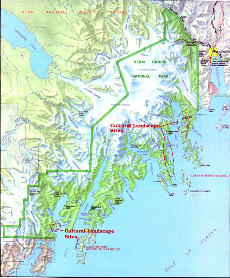
| Map 3-1. Historic Sites-European Exploration/Russian Settlement. (click on image for an enlargement in a new window) |
In the late 1700s Russian and European interests centered on southcentral Alaska. During this period, outside adventurers pursued economic opportunities on Kodiak Island, Cook Inlet, and Prince William Sound. These regions had comparatively warm microclimates, ice free protected bays, accessible forests, and pasture lands suitable for hunting and agriculture. For the most part, however, they avoided Kenai Peninsula's seaward coast. Tidewater glaciers at the mouths of deep fjords alternating with narrow jetties of rocky mountainous outcrop, as is found along the Kenai Peninsula, had few redeeming features for the development of permanent harbors, trading posts, or settlement. Fort Voskresenskii, the Russian fortified redoubt and shipyard constructed on the lowlands at the head of Resurrection Bay in 1794, [1] was abandoned after the construction of only one vessel. In the early 1800s the Russians relocated their shipbuilding industry to Kodiak and Sitka. By 1820 the Russians had begun to remove Fort Voskresenskii. As Russian investment eventually moved into other regions of Alaska, there appears to have been little regret at leaving the Kenai coast.
European Exploration and Trade on the Kenai
Peninsula
By the late 1700s, European interest and trade in southcentral Alaska increased despite Russian settlement and enterprise (see Table 3-1). Surely attracted by Russian commitment to the area's resources, English and Spanish ships entered southcentral waters in search of new routes, fame, and trade. In 1778 Captain James Cook ranked among the most noted of these first explorers. [2]
When Cook returned to England in 1780, his lucrative trade in Alaska sea otter pelts received no public attention. Mindful that the price sea otter fur brought on the Chinese market would only heighten European rivalry, Britain, then at war with the American Colonies, hoped to keep the news secret until it could afford to monopolize the fur trade. Spain, in turn, attempted to employ a similar tactic of concealment in their land claims north of California. Spain withheld official published accounts of its three expeditions in the 1770s, a move that later undermined the Spanish claims of exclusivity. [3]
The English, who protested the Spanish claims, argued that Native habitation pre-dated Spanish exploration and that the Spanish had made little attempt to establish any type of permanent settlement. [4] According to the accounts of the Russian sponsored expedition of Joseph Billings in 1790, Spanish frigates annually visited villages and forts in the vicinity of Cook Inlet trading hardware, beads, and linens for sea otter pelts. [5] Otherwise, most of the Spanish exploration originating from forts in California ventured only as far northwest as Prince William Sound (see Table 3-1).
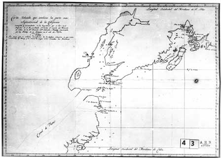
|
| Spanish Map of Cook Inlet and Kenai Coast Region, 1790. Archivo-Historico Nacional. Library of Congress. |
Table 3-1. Chronological Summary of Russian, Spanish, and English Exploration and Survey of the Kenai Coast and Prince William Sound Regions
| 1741 | Alexsei Chirikov on board the Sv. Pavel, and Vitus Bering in the Sv. Petr, set out on the Second Kamchatka Voyage and the Great Northern Expedition. In August, Chirikov sited the Kenai Peninsula and Kodiak and Afognak islands. | ||
| 1778 | In May 1778 James Cook arrived in Sandwich Sound [Prince William Sound] and then sailed west along the Kenai Peninsula to Cook Inlet. Cook surveyed the inlet in hopes of finding a Northwest Passage between the Atlantic and Pacific oceans. | ||
| |||
| 1779 | The third Spanish expedition set sail to the Northwest under the command of Naval Lieutenant Ignacio de Arteaga with F. Quiros y Miranda of the royal armada. Arteaga performed ceremonies at Port of Santiago on Hinchinbrook Island and at the entrance to Cook Inlet to claim land for Spain. The expedition traded with the Chugach. | ||
| 1781 | Evstratii Delarov, Dmitrii Polutov, and Potap Zaikov explored Prince William Sound. Russia looked to expand fur outposts and hunting expeditions to the Alaska mainland as Aleutian fur resources disappeared. Navigator Stepan Zaikov visited Prince William Sound in the vessel Aleksandr Nevskii, belonging to the Lebedev-Lastochkin Company. | ||
| 1783 | Filipp Mukhoplev and Potap Zaikov sailed to Prince William Sound from a trading station on Umnak Island. They remained until 1784 despite attacks from the Chugach. | ||
| 1785 | Grigorii Shelikhov sent a crew of fifty-two Russians and 121 Aleuts and Koniags to Kenai and Prince William Sound on a reconnaissance to "investigate possible resources, make necessary descriptions and then to continue the journey as long as summer makes it possible." | ||
| 1786 | James Strange, joined by William Tipping, anchored in Prince William Sound in search of furs to market in Canton, China. Tipping's ship, the Sea Otter, last seen in Prince William Sound, was lost at sea or attacked and destroyed. | ||
| 1786 | John Meares sailed to Chugach Bay from Kodiak via Cook Inlet in the Nootka and wintered in Snug Harbor Cove. | ||
| 1786-7 | Nathaniel Portlock and George Dixon traded with Natives at Port Graham and explored Prince William Sound in the ships King George and Queen Charlotte. Portlock and Dixon had visited the coast eight years earlier as mates on Cook's expedition. | ||
| 1788 | Captain Esteban José Martínez in the ship Princesa claimed Montague Island in Prince William Sound for Spain, as Russian and English exploration encroached on Spanish claims in the Pacific Northwest. Under orders from Shelikhov, Evstratii Delarov instructed Gerasim Izmailov and Dimitrii Ivanovich Bocharov to explore Prince William Sound in the ship Three Saints. The navigators surveyed the coast as far south as Lituya Bay, placing plaques and crests at several locations to establish Russian territory. | ||
| 1789 | Gerasim Izmailov surveyed the southeastern coast of the Kenai Peninsula after a voyage to Lituya Bay. | ||
| 1790 | Captains Joseph Billings and Gavriil Sarychev sailed along the southeast coast of Kenai Peninsula on an expedition to assess Russia's possessions. At Nuka Bay they encountered two Natives in a baidar. The ship attempted to enter the bay, but was forced to return to open waters before siting a village. Spanish sea captain Salvador Fidalgo sailed north from Mexico trading for sea otter pelts. He anchored in Prince William Sound and at Port Graham. Fidalgo encountered Russians at Port Graham and later on Kodiak Island. | ||
| 1791 | Alejandro Malaspina and José Bustamente y Guerra visited Prince William Sound on an around-the-world voyage of exploration. | ||
| 1791 | Lebedev-Lastochkin Company seized control of Shelikhov posts at Kenai on Cook Inlet and in Kachemak Bay. | ||
| 1792 | Hugh Moore repaired the British East India Company ship the Phoenix (namesake of the Russian-American Company Phoenix) in Prince William Sound where he met Aleksandr Baranov. | ||
| 1792-9 | Orekhof Company in operation. Named for a Russian trader in Prince William Sound, the company was a rival of both Shelikhov and Pavel Lebedev. | ||
| 1793 | Lebedev-Lastochkin Company established first trading post in Prince William Sound. It was Fort Constantine, at Nuchek on Hinchinbrook Island. | ||
| 1794 | George Vancouver as commander of the Discovery, surveyed Cook Inlet and Prince William Sound en route to Nookta Sound. He had first sailed to Alaska in 1772-1780, with Cook on his second and third voyages. | ||
| 1797 | James Shields, first commander of the Phoenix, mapped ship routes along the American coast, 1793-1797, and described Resurrection Bay. | ||
| 1804 | A navigator named Bubnov thoroughly surveyed the eastern coast of Kenai Peninsula to Prince William Sound. | ||
| 1849 | Russian Governor Mikhail Dmitrievich Teben'kov commissioned Illarion Arkhimandritov to survey and map Cook Inlet, the eastern peninsula coastline, and Prince William Sound. | ||
This list is meant to be representative, not conclusive. American exploration and trade are entirely omitted. Also, descriptions of trade and travel along the coast continued after 1849.
Soon after the 1783 Treaty of Paris, British trade routes developed between the northwest American coast and Canton, the only Chinese port open to international vessels. The first expedition of King George's Sound Company, also known as the London Company, navigated along the southeastern shore of the Kenai Peninsula. [6] In July 1786, company representatives Nathaniel Portlock and George Dixon left Cook Inlet, crossed Kachemak Bay and entered the narrow harbor of Port Graham. In search of a route to the Pacific, the captains assumed the harbor was an inland channel and named the small island at the entrance Passage Island. According to Portlock, Russian occupation at Port Graham appeared to be a seasonal and temporary encampment manned by twenty-five Russians and a crew of Natives from Unalaska and Kodiak islands. The Russians slept in a canvas tent while the Native crew took shelter under overturned boats pulled up on shore. There were no signs of trade with local Chugach, and Russian hunters depended on their crews to trap and hunt furs. While scouting the inner shores of the harbor, Portlock and Dixon observed several large Native huts that appeared to be recently abandoned. On the northern shores of the harbor they recorded the location of two veins of coal on the surface of the rocky hillside. Portlock wrote:
We landed on the west side of the bay, and in walking around it discovered two veins of kennel coal situated near some hills just above the beach, about the middle of the bay, and with very little trouble several pieces were got out of the bank nearly as large as a man's head.... In the evening we returned on board and I tried some of the coal we had discovered and found it to burn clean and well. [7]
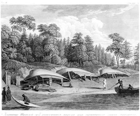
|
| Overturned boats typically served as shelters. Bancroft Library. |
In 1788 the British sea captain John Meares collaborated in a joint trading venture known interchangeably as the Associated Merchants of London and India, the United Company of British Merchants, and the South Sea Company of London. The company concentrated its trading efforts between the Queen Charlotte Islands and Prince William Sound. In 1789, Captain William Douglas received orders to trade as far as the Sound, then to turn back. The land to the west of the Sound, including Kenai Peninsula and Cook Inlet, had less potential as trading zones as "it is so totally possessed by Russians that proceeding there would be only [a] waste of the most valuable time." [8]
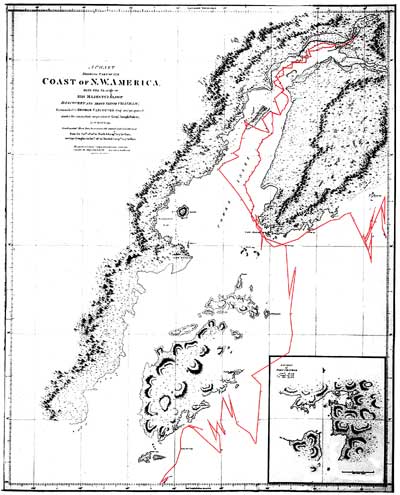
In 1790 British naval officer George Vancouver commanded his ships the Discovery and Chatham to the Pacific Northwest to reconcile British interests at Nookta. Four years later, Vancouver arrived in Alaska from Hawaii and surveyed the waters of Cook Inlet and Prince William Sound. Russian contacts in Cook Inlet led Vancouver to believe that he could bypass the Pacific coast of the Kenai Peninsula through an inland waterway at the head of Turnagain Arm. This waterway supposedly led to the Passage Canal in Prince William Sound. Learning that the waterway did not exist, Vancouver circled the outer peninsula and dismissed a survey of the coast as too time consuming. He preferred to "examine the shores of the peninsula, so far only as could be done from the ship in passing along its coast." [9] Vancouver noted the abrupt mountainous shoreline and long valleys "buried in ice and snow, within in a few yards of the wash of the sea; whilst here and there some of the loftiest of the pine trees just ‘shewd' their heads through the frigid surface." [10] From the maps of his ship route, he obviously steered clear of the bays and rocky outcrops along the Kenai coast. He recorded the Pye and Chiswell islands. He described the Chiswells as a "group of naked rugged rocks, seemingly destitute of soil, and any kind of vegetation." [11] Eighty years later, George Davidson proposed that Vancouver mistook the Chiswells for several "islets and the broken and numerous points of the long, low, wooded promontories stretching southward and forming Ayalik [sic] Bay, off which lie the Chiswell Islands." [12]
|
| Tracing of Vancouver's route (in red highlight) around the Kenai Peninsula. Alaska State Library, photo PCA 62-126. |
Thomas Heddington, a midshipman on the Chatham and the youngest member of the expedition, was one of three illustrators on Vancouver's voyage. [13] The two others were Henry Humphreys and John Sykes. Heddington prepared several surveys and drawings of the coast between Cape Elizabeth and Prince William Sound. Once back in London, Heddington submitted his work to the Hydrographic Office, but later in 1808 requested that his work be returned. The Admiralty honored the request only to lose all record or trace of the drawings. [14] One, entitled The Coast from Cape Elizabeth to the Western Entrance of Prince Williams Sound- with Elizabeth Island, Pyes Islands and Chiswells Islands off the Coast, would have been among the earliest known renderings of the coast. [15]
|
| Etching of Cook Inlet and environs, by John Sykes, Bancroft Library. Etching style similar to views that Humphreys produced of Outer Kenai Coast. |
|
| Etching of Cook Inlet and environs, by John Sykes, Bancroft Library. Etching style similar to views that Humphreys produced of Outer Kenai Coast. |
At Port Dick, a deep bay at the southern tip of the Kenai Peninsula, Vancouver encountered a large party of Natives in two-man boats. The men approached the English ships with a willingness to trade. Their number impressed Vancouver; he estimated a party of over four hundred men. Archibald Menzies, the botanist on board, described the men as being of "low stature, but thick and stout made with fat broad visages and straight black hair ... and their canoes are equally neat having their seams sown so tight as not to admit any water...". [16] In the 1930s, anthropologist Frederica de Laguna explained this encounter as one of the large inter-regional sea otter hunting expeditions that traveled along the coast. [17] Aleksandr Baranov, in a letter to Grigorii Shelikhov, recounted that Vancouver met a 500-baidarka hunting fleet of Kodiak and Chugach Natives led by Russians from the Kenai and Resurrection Bay areas in April and later again in Yakutat Bay. [18] The fleet stopped at the shipyard in Resurrection Bay to pick up five Russians, including G. Prianishnikov and Konstantin Galaktionov, and arrange for repairs and supplies of cannons, guns, and ammunition for the trip south to Icy Bay. [19]
Henry Humphreys prepared a sketch of the Port Dick encounter. In the margin of the drawing, Humphreys penciled in explanatory notes to the engraver back in England. He directed the engraver to add to the image "many canoes ... going into the Creek [sic] each carrying 2 people ... sight. Indian holding up Skins for traffic ... some going in at that place." [20] The final drawing, unlike Humphreys's original, shows the bay full of Native vessels.
Vancouver had anticipated a layover at the Russian shipyard in Resurrection Bay, but stormy seas and fog set in west of the Chiswell Islands. Apprehensive of the rocky coast and lacking accurate charts, Vancouver cancelled the stop and sailed the Discovery past Port Andrews (Blying Sound) into Prince William Sound. The route and the weather probably accounted for the poor delineation of the bay and coast in his atlas. However, his route as traced on his maps shows the wide clearance he gave to the coastline.
kefj/hrs/hrs3a.htm
Last Updated: 26-Oct-2002