

|
CHALMETTE National Historical Park |
 |
(click on image for an enlargement in a new window)
Guide to the Area
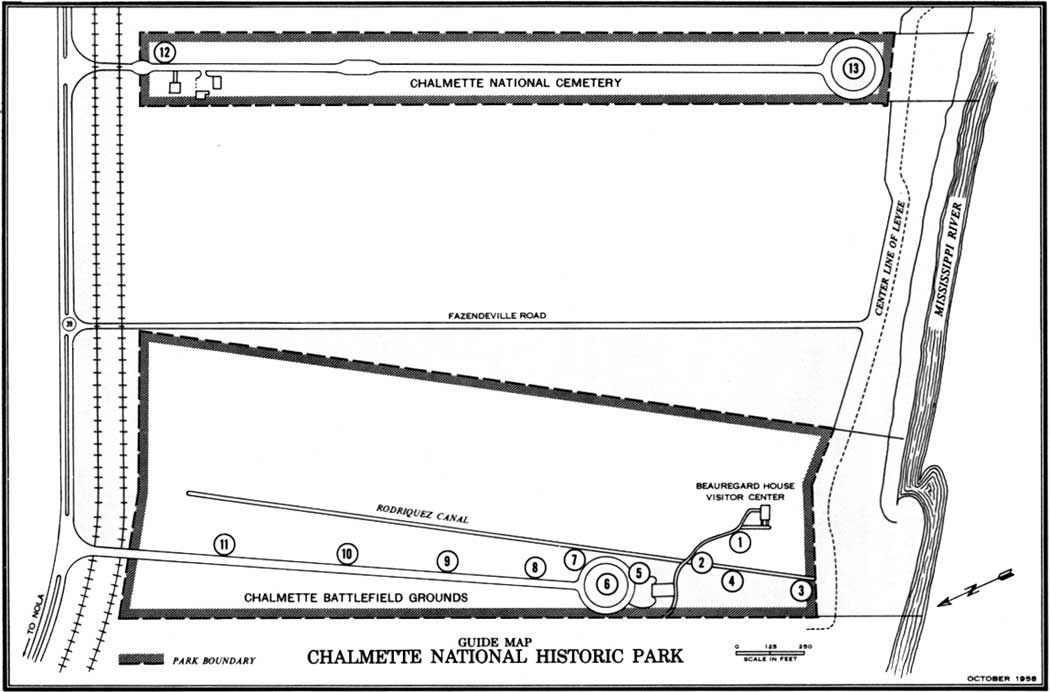
The information which follows is offered to enable you to make your own tour of Chalmette National Historical Park, including both the Monument (American Line) Section and the National Cemetery. The points of interest are numbered as they appear on the map (above) and we suggest that you follow them in order, starting with:
1. VISITOR CENTER. Here, by means of models, pictures, historic objects in story-telling arrangement, and a "talking map" with electric lights showing the action, you are introduced to the highlights of the Battle of New Orleans. Its importance in the War of 1812 and in later American history is also described. These exhibits are housed in a building which was not on the field at the time of Jackson's great victory over the British veterans in 1815. Just when it was built is not definitely known, but it certainly was one of the fine ante-bellum houses on the Louisiana shores of the Mississippi in the halcyon days before the Civil War. The name given it today is that of its last private owner, René Beauregard, son of Confederate Gen. P. G. T. Beauregard. René lived here from 1880 to 1904. In later years the house was abandoned and fell into ruinous condition. In 1957, it was restored outside and remodeled inside by the National Park Service under Mission 66, to serve its present purpose as a visitor center.
2. RODRIGUEZ CANAL. As you walk the footbridge at this point you are crossing the Rodriguez Canal, a former millrace which, even as early as 1815, had been abandoned. Using the canal as a moat, Jackson's men constructed a mud rampart back of it. From that strong position, the oddly assorted fighting force of Americans hurled back three British attacks. The Rodriguez Canal is the only trace of any manmade feature remaining on the battlefield.
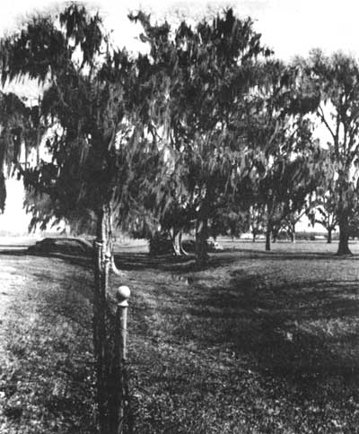
The Rodriguez Canal today. The view is away from
the river. The reconstructed section of the mud rampart is on the left.
At the time of the fighting in 1814—15, most of this land was in
fields of sugar cane, and the trees, fence, and buildings did not exist.
A cypress swamp covered the area in the background of the present
view.
Photograph by Dan Leyrer.
3. LOST BATTERY SITES. We cannot show you the position of Batteries 1, 2, and 3 of the 8 batteries of the American Line. Since 1815, the Mississippi River has claimed some 800 feet of the land on which the guns stood; the sites are now under 40 to 60 feet of muddy river water. However, the text of this handbook and the marker in place here may help you to get a picture of the situation as it was on January 8, 1815.
"Lost" Battery 1, consisting of 2 long 12-pounders and a 6-inch howitzer, near the river, helped smash the British attack at that point in the final assault on January 8.
"Lost" Battery 2, had only 1 gun, a 24-pounder served by sailors from the Carolina. The Carolina had been sunk before the main battle by British gunners firing "hot shot" (solid shot heated red hot) which set the ship on fire and caused her to blow up.
"Lost" Battery 3 had perhaps the most colorful crew on the field. The two 24-pounders were manned by the Baratarian pirates under the command of Dominique You and Renato Beluche. In the fierce artillery duel on New Year's Day, the rough-and-ready pirates outgunned the British artillerists.
4. AMERICAN LINE—BATTERY 4. Like Battery 2, this 1-gun (38-pounder) battery was served by crewmen from the ill-fated Carolina. Between this battery and pirate-manned Battery 3, the Battalion of Louisiana Free Men of Color held the line.
5. VICTORY MARKER. Here is described the importance of the victory in American history.
6. THE CHALMETTE MONUMENT. This shaft commemorates the great American victory on the Plain of Chalmette, known as the Battle of New Orleans. The cornerstone was laid January 13, 1840, but the project then entered a slumber almost as deep as Rip Van Winkle's. Revived and promoted by the Jackson Monument Association, work on the monument was started in 1855 by the State of Louisiana and, over a period of years, it rose to a height of 55 feet. In 1894 the battlefield was placed in the custody of the United States Daughters of 1776 and 1812 (later called United Daughters of 1812) who took care of it until 1929. In 1907 the land was ceded to the United States by the State of Louisiana, and the monument was completed the following year.
The plaque was installed on October 19, 1947, by the Chalmette Chapter of the United Daughters of 1812.
7. MUD RAMPART AND BATTERY 5. The pile of earth which you see is a reconstruction of a very small section of the mud rampart, or wall, which Jackson's men hurriedly constructed, by the general's orders, on Christmas Eve of 1814. The 1814—15 version of this crude fortification, with the Rodriquez Canal in front of it, proved a most effective barrier to the British advance. Extending, as it did, from the Mississippi River on the right to the great swamp on the left, it gave the British no alternative but to make direct frontal attacks upon the American Line, or "Jackson Line" as it is sometimes called. The American sharpshooters and gunners, relatively secure behind the mud rampart, wrecked terrible execution in the British ranks charging across the Plain of Chalmette.
Near the present marker, Battery 5 challenged the British.
8. BATTERY 6. This battery, together with Batteries 7 and 8, was particularly effective on critical January 8 as it poured round after round of shot and grape into British General Gibb's advancing column. The battery was commanded by Gen. Garrigues Flaujeac, veteran of Napoleon's army and a member of the Louisiana Legislature.
It was supported magnificently by musket fire from a nearby company of United States Marines and by the deadly accurate, if relatively undisciplined, fire delivered by Kentucky volunteers.
9. BATTERY 7. Professional soldiers—regular artillerymen of the United States Army—manned this battery. Supporting the battery were Tennessee Militia under command of Maj. Gen. William Carroll, later elected Governor of that State six times. This part of the American Line bore the brunt of the decisive action on January 8. Cannon fire tore holes in the red-coated ranks and the unerring aim of the Tennessee frontiersmen completed the execution. A few British soldiers reached the mud rampart only to perish there. The supreme effort for a breakthrough was made here and at Batteries 6 and 8. It failed and the British attempt to capture New Orleans was defeated.
10. BATTERY 8. Kentucky troops supported the one gun here which was commanded by a regular-artillery corporal. The name of the corporal and the type of gun are not known and so the marker is entitled "The Mysterious Gun." It is known, however, that this small "battery" joined with the two to its right to break the last desperate British charge in the final phase of the Battle of New Orleans.
11. GENERAL COFFEE'S POSITION. The holding of the left end of the American Line, which lay in the swamp, was the disagreeable assignment of the Tennessee volunteers under Brig. Gen. John Coffee, veteran commander of "mounted infantry" and friendly Indians in the Creek Indian War. Coffee's men at Chalmette had raided the British camp in the night attack of December 23, 1814. On New Year's Day, from their position behind the rampart, they had broken the only British charge of that day. On decisive January 8, they held the same position with a determination not chilled by the cold water and mud which all but engulfed them.
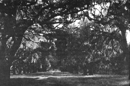
The De La Ronde Oaks. Probably planted about about
1820, they grew where Jackson formed his men for the Night Battle of
December 23, 1814. They are often miscalled "Pakenham Oaks" or
"Versailles Oaks" and are located on private property near the
park.
Leaving the Monument Section of Chalmette National Historical Park, you may turn east (right) on the highway to reach:
12. CHALMETTE CEMETERY. Established as a National Cemetery in 1864, this hallowed ground holds, in honor, the remains of more than 15,000 veterans of our Nation's wars. Of these, 6,700 are unknown. The cemetery was closed for burials in 1945 but is open for visitation by those wishing to pay respects to the defenders of our Country who have their last resting place here.
13. G. A. R. MONUMENT. In 1874, the Grand Army of the Republic (a society of Union veterans of the Civil War) erected this monument to the memory of their comrades-at-arms buried in Chalmette National Cemetery. It was originally placed in the center of the cemetery, but was moved, in 1956, to its present location at the River Terminal Circle of the cemetery's magnolia-lined drive. Notice the in scription, DUM TACENT CLAMANT ("While They Are Silent, They Cry Aloud")—the Federal soldiers' last salute to their comrades in the graves at Chalmette.
This concludes the self-guiding tour. We hope that you have received, from your visit to Chalmette National Historical Park, real inspiration and a greater understanding of a part of the American story.

|

| History | Links to the Past | National Park Service | Search | Contact |
|
Last Modified: Mon, Dec 2 2002 10:00:00 am PDT |