

|
YORKTOWN National Battlefield |
 |
How to Reach Yorktown
Yorktown is on U. S. 17 and is located 106 miles south of Fredericksburg and 32 miles north of Norfolk, Va. The approach from the north is from Gloucester Point by a bridge over the York River. U. S. 60 and State Route 168 pass a few miles to the west and are connected with Yorktown by State Route 238. The nearest rail terminal is 5 miles away at Lee Hall. Buses of the Greyhound Lines connect with York town, and special sightseeing buses operate from Williamsburg.
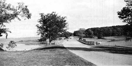
The Colonial Parkway with the York River on the left.
Colonial Parkway
The most interesting approach to Yorktown is from Williamsburg by car over the Colonial Parkway. This highway, combining scenic beauty and historical interest, is a part of Colonial National Historical Park and connects Yorktown and Jamestown, two of the principal areas in the park, by way of Williamsburg. From Yorktown it follows the high ground along the south side of the York River for approximately 5 miles and then turns inland to traverse forested countryside into Williamsburg—Virginia's 18th-century capital. The route then is south to the James and along this river to Jamestown. Parking overlooks have been provided at vantage points and markers carry informative messages about history and locality. There is a picnic ground adjacent to the roadway about midway between Yorktown and Williamsburg.

|

| History | Links to the Past | National Park Service | Search | Contact |
|
Last Modified: Mon, Dec 2 2002 10:00:00 am PDT |