

|
YORKTOWN National Battlefield |
 |
Guide to the Area
(continued)
BATTLEFIELD TOUR.
A self-guiding auto tour begins and ends at the Visitor Center. Along the drive are the major points of interest which are briefly described below. The complete tour is some 15 miles long but you can take a shorter tour of the 5-mile inner loop. It embraces the battlegrounds, the French and American encampment areas, and the village of Yorktown. The route is marked by uniform signs.
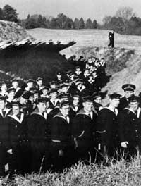 French sailors visit British Redoubt No. 9 which their countrymen captured in 1781. |
2. REDOUBT NO. 9 (reconstructed). A detachment of 400 French soldiers distinguished itself on the night of October 14 by storming this British strong point. The fall of this redoubt, and its neighbor, Redoubt No. 10, which was stormed by the Americans on the same night, was a decisive action of the siege.
3. AMERICAN BATTERY NO. 2, SECOND ALLIED SIEGE LINE. Erected after the capture of Redoubts Nos. 9 and 10, it was one of the most important positions of the second siege line. There are several original artillery pieces mounted in this reconstructed battery.
4. REDOUBT NO. 10. Close to the edge of the riverbank, a small part of the moat of this siege position is preserved and the parapet has been rebuilt. This is all that now remains. The rest of the position has been destroyed by erosion of the cliffs in the years since 1781. It was captured from the British on the night of October 14 in a bayonet attack led by Alexander Hamilton. Among those who distinguished themselves was Sgt. William Brown who later was the recipient of one of the first Purple Heart awards ever made. This award then was made only for extraordinary bravery in action.
Five days after its capture, the allied leaders met in Redoubt No. 10 and affixed their signatures to the Articles of Capitulation which already had been signed by the British commanders. This is, perhaps, the most memorable spot on the Yorktown Battlefield.
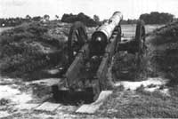 The Lafayette Cannon—a 12-pounder made by W. Bowen in 1759. |
5. AMERICAN SECTOR, FIRST ALLIED SIEGE LINE. The route now leads across the field, open as in 1781, between the allied lines. Part of the reconstructed communicating trench is visible. The next stop is in the American sector of the first siege line at a point where the Americans began to build their entrenchments (partly reconstructed).
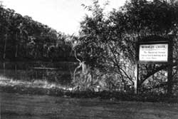
6. AMERICAN APPROACH ROAD. The tour now follows the road used by the American troops as they approached the fighting line. It passes the location of their temporary supply depot. It is of interest to note that the road is well down in a ravine and this gave protection from shellfire. It led to the encampment area where troops bivouacked and lived. Before crossing Wormley Creek, however, the road turns back toward the York River.
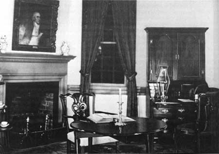
"Surrender Room" in Moore House where the Articles of Capitulation
were drafted.
7. MOORE HOUSE. Here in the private home of Augustine Moore on October 18, 1781, commissioners met to draft the Articles of Capitulation. Constructed about 1725, the restored house is furnished as a home of the 1776—81 period. It is open daily.
 Mill dam road across Wormley Creek. |
8. MOORES MILL DAM. On the return from the Moore House the tour crosses Wormley Creek over a dam where Augustine Moore had a grist mill, as part of his 500-acre plantation. Ice for storage was probably cut here in winter.
The marked drive now passes through a section of the American encampment. Markers identify the more significant sites including:
9. BENJAMIN LINCOLN'S HEADQUARTERS SITE and
10. LAFAYETTE'S HEADQUARTERS SITE.
11. SURRENDER FIELD. The next stop is at the south end of the field where the British laid down their arms as called for in the Articles of Capitulation. A sweeping view of a part of this field is possible from a raised platform especially designed for the purpose. In front of this is the trace of the old Warwick Road and bounding it on the right is the still existing York-Hampton Road. It was along the latter that the British troops marched out from Yorktown and this section of it is now known as Surrender Road.
12. SURRENDER ROAD. From Surrender Field it is possible to go directly back to Yorktown. It is suggested, however, that the route through the encampment area and to the British outer works be chosen.
13. ENCAMPMENT DRIVE. Here the road passes through historically interesting, and scenically beautiful, countryside. This is the only access to such areas as:
A. Von Steuben's Headquarters Site. Major General von Steuben, like Lincoln and Lafayette, commanded a division of American troops.
B. Rochambeau's Headquarters Site. Rochambeau commanded the French Army under Washington.
C. Washington's Headquarters Site. This is reached by a spur road from the main tour drive. The ford, restored to use as it was in 1781, is safe for vehicular travel.
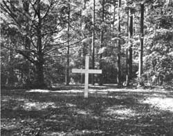 The French Cemetery in the battlefield encampment area. The cross marks the traditional burial site. |
D. French Cemetery. This is thought to be the burial site of a number of the French soldiers killed during the siege.
E. French Artillery Park. This was a place for repairing and storing cannon. Existing ground evidences indicate the manner in which carriages were parked.
F. French Army Encampment.
G. British Outer Works. Cornwallis constructed several positions between the headwaters of Yorktown and Wormley Creeks as a part of his outer line. One of these has been partly reconstructed and is visible from the tour road. Another is an original position which remains undisturbed. A spur road from the main tour route gives access to it in the area known as "Long Neck."
14. GRAND FRENCH BATTERY. This position was the largest and one of the most effective in the First Allied Siege Line. A part of it, including gun platforms and magazines (powder and ammunition storage points), has been reconstructed. The artillery now mounted here (a trench mortar, siege cannon, mortars, and howitzers) are types used in the Revolutionary period. Some of the pieces were actually used at Yorktown during the siege.
15. NATIONAL CEMETERY. Established in 1866, this is chiefly a burial ground for Union soldiers killed in the vicinity in the Civil War.
16. SECOND ALLIED SIEGE LINE. This is another point on the same encircling line that came to include British Redoubts Nos. 9 and 10.
17. YORKTOWN. The tour now enters Yorktown proper where the British army was encamped and in which it made its stand. The old Civil War line rings the town today and under it is the British line of 1781.
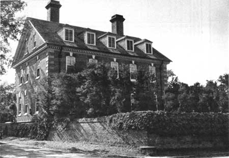
The Nelson House where Cornwallis may have had his
headquarters in the last days of the siege.
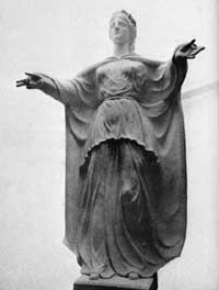 The figure of "Liberty" atop the Yorktown Victory Monument. Sculptured by Oskar J. W. Hansen. |
A. Site of Secretary Nelson's House. Here Cornwallis had his headquarters when the siege opened. He remained until allied artillery forced him out. Secretary Thomas Nelson was, for many years, Secretary of the Colony of Virginia. The site has been marked by the Yorktown Branch of the Association for the Preservation of Virginia Antiquities.
B. Victory Monument. Authorized by Congress in 1781, the shaft was nor begun until 1881 (completed 3 years later) as a part of the Yorktown Centennial Celebration. The original figure of "Liberty" was damaged by lightning in 1942 and replaced by a new figure in 1956.
C. Cornwallis Cave. This natural cave in a marl cliff was undoubtedly used by the British in 1781. Staff conferences could have been held here late in the siege.
D. Nelson House. This residence is believed to have been Cornwallis' headquarters in the last days of the siege. It was built prior to 1745 by "Scotch Tom" Nelson and was later the home of his grandson, Gen. Thomas Nelson, Jr. The house has cannonballs imbedded in its east wall that are thought to have been fired during the siege of 1781.
18. FUSILIERS REDOUBT. Located on the west side of Yorktown, it protected the road to Williamsburg. Because of erosion of the bluffs at this point, it has been possible to reconstruct only a part of the original position.

|

| History | Links to the Past | National Park Service | Search | Contact |
|
Last Modified: Mon, Dec 2 2002 10:00:00 am PDT |