.gif)
Cover Page
MENU
The Wawona Hotel and Thomas Hill Studio
Yosemite
Bathhouse Row
Hot Springs
Old Faithful Inn
Yellowstone
LeConte Memorial Lodge
Yosemite
El Tovar
Grand Canyon
M.E.J. Colter Buildings
Grand Canyon
Grand Canyon Depot
Grand Canyon
Great Northern Railway Buildings
Glacier
Lake McDonald Lodge
Glacier
Parsons Memorial Lodge
Yosemite
Paradise Inn
Mount Rainier
Rangers' Club
Yosemite
Mesa Verde Administrative District
Mesa Verde
Bryce Canyon Lodge
Bryce Canyon
The Ahwahnee
Yosemite
Grand Canyon Power House
Grand Canyon
Longmire Buildings
Mount Rainier
Grand Canyon Lodge
Grand Canyon
Grand Canyon Park Operations Building
Grand Canyon
Norris, Madison, and Fishing Bridge Museums
Yellowstone
Yakima Park Stockade Group
Mount Rainier
Crater Lake Superintendent's Residence
Crater Lake
Bandelier C.C.C. Historic District
Bandelier
Oregon Caves Chateau
Oregon Caves
Northeast Entrance Station
Yellowstone
Region III Headquarters Building
Santa Fe, NM
Tumacacori Museum
Tumacacori
Painted Desert Inn
Petrified Forest
Aquatic Park
Golden Gate
Gateway Arch
Jefferson National Expansion
|
Architecture in the Parks
A National Historic Landmark Theme Study |

|
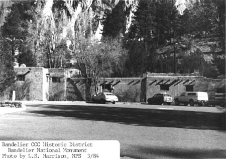
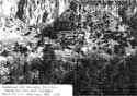
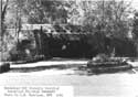
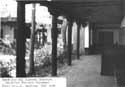
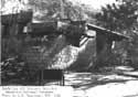
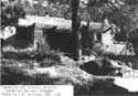
Bandelier National Monument CCC Historic District, Bandelier NM, 1984.
(Photo by L.S. Harrison)
Bandelier National Monument CCC Historic District
| Name: | Bandelier National Monument CCC Historic District [preferred] (Bandelier Buildings and Frijoles Canyon Lodge) |
| Location: | Bandelier National Monument |
| Agency: | National Park Service Southwest Regional Office |
| Condition: | Good, altered/unaltered, original site |
| Classification: | District, public, accessible (unrestricted/restricted), government/museum/government residence |
| Builder/Architect: | Lyle Bennett and other NPS personnel |
| Dates: | 1933-present |
DESCRIPTION
The Bandelier CCC Historic District contains 31 buildings all of pueblo revival design executed with a solid architectural unity that romantically mimicked a small New Mexican village. Designed by National Park Service architects and landscape architects and built by the Civilian Conservation Corps, this group of buildings provided a complete development for a national monument--from office space and residences for employees to lodging for guests.
Included within the Bandelier CCC Historic District are the thirty-one buildings, an entrance road, and minor structures such as stone water fountains and faucets in the former campground. Twenty-nine of the buildings are in Frijoles Canyon--a green canyon cut into the Pajarito Plateau containing thirteenth through sixteenth century cliff dwellings, other archeological features, and a permanent stream. Two of the buildings are on the mesa top along the entrance road that leads down into the canyon.
The buildings were designed as the administrative, residential, and maintenance core of Bandelier National Monument, and as a lodge for tourists who visited the monument. The lodge was necessary because other accommodations were in Santa Fe, reached in the 1930s by eighteen miles of poor dirt road and seventeen miles of partially paved highway.
The buildings are pueblo revival structures (also called Spanish pueblo style), and nearly all are single-story structures. The only two-story structures are a small former concessioner's residence (B-18) and the fire lookout (B-30). The main buildings were designed to give the appearance of a small southwestern village wrapped around three sides of a central wooded plaza. The fourth side of the plaza is a green strip bordering the stream known as Rito de los Frijoles. Additional lodge units and the monument's residential and maintenance areas were built off the main plaza. The lodge units were reached by a series of flagstone pathways that led up from the lodge lobby (B-17) through small courtyards and patios that stepped up the hillside on several levels and that were planted with native vegetation. The maintenance yard, built parallel to the entrance road, was walled off from visitor view. The rear of one of the maintenance buildings (B-3) provided a third (southeast) side of the plaza. The residential structures were tucked away up the hillside from the entrance road, hidden from visitor view by vegetation and topography. The two main street facades were in front of the lodge lobby and dining room (B-17 and B-15) and in front of the museum/headquarters (B-2).
The buildings and the spaces between the buildings created a very strong sense of place still evident today. This sense of place, with its extremely evident New Mexican flavor is primarily due to the thoroughness of design--from the landscape architecture that is inseparable from the building architecture, down to the interior design details. The quality of workmanship of everything from the stone-cutting to the finish details of the furnishings was extremely high. The craftsmanship of the Bandelier CCC camp was held up as the prime example of CCC accomplishments throughout all of the southwestern national parks and monuments. The woodworkers were so good that they were entrusted to make the doors for the new museum at Tumacacori National Monument, which replicated the extremely decorative work from the doors of another Spanish colonial mission. The quality of the architectural and landscape design was as high.
All of the buildings were constructed of stone -- Bandelier rhyolite tuff. The buildings were connected to each other by a series of stone walls, plastered portals, flagstone walkways, and stone-edged planting beds. The entrance road was partially bordered with a stone guardrail and stone-lined gutter. The consistent use of stone created an. overwhelming sense of visual unity. The interplay of masses and voids, with a solid building mass relieved by a recessed portal, for instance, added spatial diversity to that strong unity.
The buildings responded to the existing topography--from the flat canyon floor to the steeper terrain up toward the base of the cliffs. As an example, one lodge structure (B-19) was constructed on several levels as it proceeded up toward the base of the cliffs. The stepped parapets along the roofs appropriately reflected these elevation changes. This response to the topography provided an additional organic tie between the buildings and the site. The placement of the buildings created additional spaces--the spaces between the buildings had as much architectural interest as the spaces inside the buildings.
The buildings were all constructed with similar architectural elements, and they are summarized here along with alterations that have occurred to the buildings as a group over the years. The list that follows includes the building numbers, names, date of construction, original use, present use, and any other noteworthy alterations.
Nearly all of the buildings were constructed with stone footings. Walls were gently battered and washed with a thin coat of mud plaster, designed to wear off giving the rough coursed ashlar masonry a more weathered and used appearance. Projecting viga (round, peeled beam) ends were cut with an axe, emphasizing a more primitive appearance. Parapets surrounded the roofs, which were drained by canales (scuppers). Most windows were multi-light casements of wood frame construction. Some of the windows (B-1) were covered with band-sawn grilles in zig-zag patterns. Heavy wood doors were mortised together with multiple inset panels or were three layers of thick tongue-and-groove (V-groove) boards. Doors and windows were capped with large hewn lintels. Portal walls were stuccoed and painted. The original mud plaster finish in some of the portals was removed shortly after construction due to maintenance problems and replaced with stucco. Corbels topping the columns supporting portal roofs were decoratively carved with Spanish colonial designs.
On the interiors, most ceilings were peeled vigas, supporting aspen latias in perpendicular or herringbone patterns. Rooms were built with corner fireplaces, one of the main sources of heat. Many rooms had bancos (built-in benches) and built-in shelves. Most interior walls were finished with hard plaster, often painted with Spanish colonial and Indian designs. Interior woodwork in some of the buildings (B-2, B-17) was carved in extremely decorative designs (railings, built-in shelves, panelling, corbels, beams, etc.). Room configuration had the typical pueblo revival additive quality, where a link between one room and the next often meant a small change in level of one or two steps. Most floors were flagstone, varnished to a high gloss, although concrete and some wood floors were constructed.
Furniture for each building was constructed by the CCC and included desks, beds, wood boxes, and chairs for the lodge cabins. The CCC built couches, chairs, and coffee tables for the lodge lobby, and dining tables and chairs for the dining room--all of spanish colonial design. Even the hardwood curtain rods in the interiors picked up the architectural theme. Light fixtures, mirrors, and switchplates were also of spanish colonial design. The development also benefitted from the Federal Arts Project. Pablita Velarde did a series of paintings for the museum. Helmut Naumer completed four pastels of Rio Grande pueblo scenes. Chris Jorgensen did a watercolor of desert scenery. Sculptor Raymond Terken made models for museum exhibits.
Original uses for the buildings included an administrative center for the monument, a lodge with a dining room and cabins for tourists, a maintenance area, and a residential area. Some of those uses have changed and are detailed in the building list that follows, but they are briefly summarized here. The lodge closed permanently in 1978 after more than a decade of diminishing operations. Lodge cabin units were converted to park housing and office spaces. Most of the lodge units were constructed with two bedrooms sharing a bath. As housing, one bedroom was turned into a living room/kitchenette, and the other left a bedroom. The administrative office functions of the monument were moved into the former lodge dining room and employee dormitory (B-15 and B-16). When the dining room and lunch room closed, the concessioner opened a small snack bar in the former curio shop attached to the old lodge lobby. The lodge lobby was turned into a new, larger curio shop (all in B-17). These changing functions necessitated some interior modifications also summarized in the building list. The maintenance and other residential structures have retained their uses with only minor building modifications.
Most of the buildings were originally heated with a variety of fuels--propane, wood, oil, and coal. These multiple fuels were replaced with natural gas during the 1960s and early 1970s. Gas wall furnaces were installed in most of the buildings at that time. The original built-up roofs were replaced with a spray urethane foam treatment in 1980. Many of the original furnishings remained in use in the structures; others were accessioned into the park collection. and are in storage. Original lighting fixtures remain, but have been augmented in office spaces by removable fluorescent lights. All original furnishings, art work, and light fixtures are covered by the nomination form. Other changes included the enclosing of several portal bays with removable wood frame partitions for concessioner's storage. The wooded plaza was cut into in 1952, and essentially turned into a wooded parking island. The original multi-light casement windows in the residential buildings were replaced with insulated thermal-pane casements about 1980. Skylights were added to a few of the residential structures about the same time. In general, the exteriors look very much as they did shortly after construction. Most of the interior changes were done without harming historic fabric, so they are reversible. Two small pit toilets constructed concurrent with the fire lookout and the entrance station were demolished within the past twenty years. Other than those, all of the buildings constructed by the CCC remain.
The buildings are in fair to good condition. On-going projects include rehabilitation of water, sewer, electrical, and gas lines; replacement of flagstone and curbstone; rehabilitation of decaying wood structural members; and installation of insulated windows and fire alarm systems.
List of Buildings
Note: "Original use" is the historic name and/or use; "present use" in most instances is the name by which the building is commonly known today, in addition to its number.
B-1: 1934
Original use: comfort station and public showers for former campground.
Present use: comfort station for picnic area.
Alterations: pumice block partition. in men's room shower, 1959; concrete block retaining wall behind structure to help drain water away from building, unknown date.
B-2: 1935 and 1936, 1939-40
Original use: originally two structures, the museum (1936) and the administrative offices (1935), connected by a portal; addition constructed between the two buildings in 1939-40 which added a lobby behind the portal.
Present use: visitor center.
Alterations: most of old office space converted to audio-visual room in 1969, resulting in removal of wood frame office partitions, light-proofing windows, blocking off small portion of window at rear of building for AV equipment.
B-3: 1935
Original use: warehouse. Present use: warehouse.
Alterations: interior partitions of wood frame and metal lath added in 1939, and more windows added at that time while portion of building used for office space. 1945-1953+ northeast portion of building used as two-room apartment.
B-4: 1935
Original use: garage and blacksmith shop.
Present use: carpenter's shop.
Alterations: fire in 1938 necessitated partial rebuilding of structure; new lighting installed 1977.
B-5: 1935
Original use: gas and oil house.
Present use: gas and oil house.
Alterations: modern gas pumps and bollards added in recent years, replacing earlier units.
B-6: 1935-36
Original use: garage.
Present use: equipment shed (for storing lumber and forest fire suppression tools).
Alterations: six of the eight bays enclosed, and interior partitions constructed by 1977; concrete floor poured over original gravel floor in 1977.
B-7: 1936
Original use: residence.
Present use: residence.
Alterations: wood storage shed, 1939; bedroom addition, 1941; kitchen cabinets installed 1967; thermal pane windows installed 1977.
B-8: 1937
Original use: residence.
Present use: residence.
Alterations: wood storage room added 1939; living room converted to bedroom and new living room constructed 1941; kitchen remodelled and back patio enclosed 1973.
B-9: 1935
Original use: comfort station.
Present use: comfort station.
Alterations: 1940 alteration to allow for installation of furnace; interior rehabilitated in 1966; back wall of toned slump block constructed on portal in recent years (date uncertain).
B-10: 1937
Original use: ranger dormitory and garage.
Present use: temporary quarters, garage, and laundry room.
Alterations: laundry room addition constructed 1940; southeast living space remodelled into kitchen and porch enclosed with slump block wall in 1973; thermal pane windows installed, probably 1978.
B-11: 1937
Original use: residence.
Present use: residence.
Alterations: wood storage building and root cellar added 1939.
B-12: 1937
Original uses: CCC carpentry building, then concessioner's storage and laundry building beginning in 1941.
Present use: storage.
Alterations: southeast end of building partitioned off into laundry space in 1941; partitioned room further divided into two more additional spaces in recent years (unknown date); concrete block addition constructed on northwest corner of building (unknown date).
B-13: 1937
Original use: garage for Frijoles Canyon Lodge.
Present use: meeting room.
Alterations: smaller doors and windows added in large garage bay doors, unknown date.
B-14: 1939
Original use: oil and gas house, Frijoles Canyon Lodge.
Present use: office supply storage.
Alterations: gas pump, which is old and may be original, has been moved four feet from original location and mounted on small concrete pedestal.
B-15: 1937
Original use: Dining room, kitchen, and lunch room for Frijoles Canyon Lodge.
Present use: half of park administration building.
Alterations: dining terrace covered with fiberglass roof in 1960; 1968 changes included partitioning kitchen and lunch room into office spaces after removing equipment, constructing an insulated roof over the dining terrace, and partitioning a small portion of the dining terrace into office space.
B-16: 1938
Original use: employee dormitory, Frijoles Canyon Lodge.
Present use: half of park administration building.
Alterations: connected to B-15 in 1968 as part of the remodelling, by construction of dining terrace roof; back terrace enclosed at later (unknown) date.
B-17: 1939
Original use: Lobby and sales room, Frijoles Canyon Lodge.
Present use: sales room remodelled into snack bar in 1968; lobby and writing room turned into souvenir shop sane year.
B-18: 1938
Original use: operator's residence, Frijoles Canyon Lodge.
Present use: housing for Mrs. Evelyn Frey, the former operator and a park VIP.
Alterations: none, other than changes in heating system.
B-19: 1939
Original use: Cabin Group A, Frijoles Canyon Lodge.
Present use: park housing.
Alterations: kitchenettes added between 1968 and 1978.
B-20: 1938
Original use: Cabin Group B, Frijoles Canyon Lodge.
Present use: park housing.
Alterations: kitchenette added, between 1968 and 1978.
B-21: 1938-39
Original use: building known as "the kiva" and contained the lodge's hot water system, cedar closets for linen storage in the basement, and men's and women's restrooms and a utility room on the first floor.
Present use: park storage.
Alterations: none known.
B-22: 1938
Original use: power house.
Present use: power house.
Alterations: machinery changed on interior when the monument obtained commercial electrical service.
B-23: 1939
Original use: Cabin Group D, Frijoles Canyon Lodge.
Present use: park offices.
Alterations: fluorescent lights added to augment historic lights in 1977.
B-24: 1939
Original use: Cabin Group C, Frijoles Canyon Lodge.
Present use: office space and park housing.
Alterations: kitchenettes added to two units at the southwest end of the building, between 1968 and 1978.
B-25: 1939
Original use: stable and chicken house, Frijoles Canyon Lodge.
Present use: stable for monument stock.
Alterations: six stalls rehabilitated in 1953; new pole corral constructed 1956; minor changes to living quarters, 1968.
B-26: 1940
Original use: entrance station.
Present use: entrance station.
Alterations: portion of patio wall removed in 1965; stop lights installed on building in 1976.
B-27: 1940
Original use: Cabin Group E-1, Frijoles Canyon Lodge.
Present use: park housing.
Alterations: kitchenettes installed between 1968 and 1978.
B-28: 1940
Original use: Cabin Group E-2, Frijoles Canyon Lodge.
Present use: park housing.
Alterations: kitchenettes added between 1968 and 1978.
B-29: 1940
Original use: Cabin Group E-3, Frijoles Canyon Lodge.
Present use: park library and curatorial storage.
Alterations: southeast unite partitioned into two rooms in 1980, celotex ceiling installed, styrofoam placed over windows, and plumbing fixtures removed from the bathroom; library underwent considerably less alteration; bars installed on windows, unknown date.
B-30: 1941
Original use: Fire lookout.
Present use: fire lookout.
Alterations: kitchen/bathroom addition built on to small first floor residence in 1956; window framing angle changed from perpendicular-to-the-ground to angling further out toward the eaves (date unknown); new steps and guardrail constructed around catwalk in 1977.
B-32: 1941
Original use: monument custodian's residence.
Present use: superintendent's residence.
Alterations: skylight installed in 1981; thermal pane windows installed circa 1978.
Archeological Potential.
Because of location at the base of cliff dwellings that received intensive use over several centuries, archeological potential within the canyon section of the district would seem to be high. The massive amount of excavation required for each building, however, lowers the potential for prehistoric resources. The historic records covering the building construction make no note of any archeological resources found in the process of construction. All those working on construction of the buildings--from the architects to project superintendents to laborers--were aware of Bandelier's archeological resources and the laws governing their protection. The CCC enrollees were taught about the importance of the archeological resources. Archeologist Paul Reiter and others were working on stabilizing ruins just a short distance away in the canyon. The landscape architect was very cautious about his placement of a baseball field for the CCC enrollees, but he never wrote of similar concerns on the placement of the buildings. The records do indicate noteworthy archeological discoveries in other areas of the monument, but no mention is made in connection with construction.
Potential for sub-surface historical archeological resources on the mesa top, edging the road into the canyon, and in the canyon proper exists but is limited. The CCC destroyed all of the old buildings in the canyon, including any buildings that may have been left over from the time that Judge Abbott and his wife occupied the canyon (1907) and the buildings constructed by George and Evelyn Frey for the old hotel/dude ranch they ran in the canyon (1925+). The CCC filled in a portion of a historic irrigation ditch and turned it into a trail. The CCC also removed what remained of "an old Mexican cabin" that appeared on a 1932 map. The CCC did not disturb the historic "threshing floor" that appeared on the earliest survey maps. When the CCC moved out of the canyon, the National Park Service cleaned up and "naturalized" the site of the former CCC camp and regraded the area to more natural contours. Thus, most surface remains probably were removed or disturbed, with the exception of Mrs. Frey's orchard and a section of the irrigation ditch she used. Additional historical archeological resources in Frijoles Canyon may turn up in the course of the monument s archeological survey, which will be conducted within this decade.
Intrusions
The only non-conforming intrusion is a temporary metal building--a portable storage building -- next to B-29. This structure is only visible behind B-29.
Exclusions
Trails constructed by the CCC within the monument were not included in this National Register Form. So much change has occurred to the trails over the years--primarily re-building because of damage caused by natural forces--that discerning exactly which portions were CCC-built and which sections were of more recent origin would he nearly impossible. The trails were well designed and laid out by landscape architects, but this fact alone does not make them eligible. They were built to follow reasonable grades and with appropriate scenic interest to keep the hiker occupied while proceeding to major archeological features throughout the park. The construction of the trails did not entail anything of major engineering significance. The small bridges constructed by the CCC were either entirely removed or replaced through the years. Sections of trails built by the CCC were re-routed for resource management concerns. Minor changes still occur to the trails each year. For these reasons, the trails did not have enough integrity or significance to be included on this nomination form.
STATEMENT OF SIGNIFICANCE
The Bandelier CCC Historic District is of exceptional significance in American architecture. As a group the district represents a significant, distinctive and exceptional entity of pueblo revival (or Spanish-pueblo) style architecture. The district possesses an architectural unity of theory and style that begins with the site and building design and continues through into the finer interior details. All of the work was executed at extremely high standards of craftsmanship, which makes the district even more remarkable considering the meager funding and lack of skilled labor. The district is a prime example illustrating the guiding principles of National Park Service architecture (often called "rustic architecture" or "parkitecture") that developed during the 1920s and 1930s. Also, the Bandelier CCC Historic District is the largest collection of CCC-built structures in a national park and perhaps in the nation that has not been altered by the addition of new structures within the district.
The Bandelier CCC Historic District is of regional significance in American social history. First, the Bandelier CCC Camp employed several thousand men, mostly local New Mexican people, from 1933 to 1941 as part of President Franklin D. Roosevelt's New Deal. Not only did the unskilled people involved learn building and crafts skills in carrying out NPS designs, but they received so much on-the-job training that they carried out this extremely ambitious program at levels of skill comparable to master craftsmen. Second, the buildings played a minor supportive role during World War II to top-secret Project Y of the Manhattan District Engineer (the "Manhattan Project") by housing nuclear physicists, technicians, and contractors connected with the development of the atomic bomb at Los Alamos a few miles away.
From the earliest days of the National Park Service, architects, landscape architects, and park service directors had definite ideas about the sorts of structures they felt were suitable for national parks, spurred on by great minds in the private sector such as Frederick Law Olmsted, landscape architect James S. Pray of Harvard University, and J. Horace MacFarland of the American Civic Association. Experimentation in building style and site design throughout the 1920s resulted in the formulation of the principles of what is now termed "rustic architecture." New graduates and young apprentice architects and landscape architects were pulled into the park service and schooled in this "environmental design," under the guidance of NPS landscape architect Thomas Vint and others.
The basic precept of "rustic architecture"--or "parkitecture" as they sometimes called it--was that any structure built in a park should harmonize with its environment. Every fireplace and picnic table, and every comfort station, ranger cabin, and visitor center should look as if it belonged in its setting. Structures harmonized with their natural environments through the use of onsite or locally available materials, such as granite and massive timbers in Yosemite, and rhyolite tuff at Bandelier. Structures also related to the surrounding topography through shape and form. Here they were designed to fit the canyon floor and gradually rise up to the base of the cliffs. In addition, structures often reflected appropriate local cultural traditions--pueblo revival in the southwest, or colonial revival in the east. Careful landscape planning, which here included staining of blasted rocks along the entrance road to make them appear more weathered, contributed greatly to the overall effect. Rustic architecture was not a style, even though its practitioners often referred to it as such. Rather, it was a movement that could incorporate within its grasp any number of styles, and at Bandelier the chosen style was pueblo revival.
The style chosen for development in each National Park area was not necessarily devoid of outside architectural influences. As long as an architectural style fell within the precepts of rustic building design, its designers considered it appropriate. Pueblo revival--with its natural building materials, battered walls, and small scale--was appropriate. The international style, with so much concrete, straight lines, and banded windows, would not have been considered appropriate. The adoption of pueblo revival fit the Bandelier locale perfectly -- both in the choice of materials and recent architectural trends. A large proportion of new construction in Santa Fe was being done in what was termed the "Santa Fe style" (heavy on the adobe, vigas, corner fireplaces, latias, decorative corbels, and the like) at the time. A series of New Mexico mission churches were preserved or creatively restored during the 1920s and early 1930s. La Fonda, the large hotel in downtown Santa Fe, had a pueblo revival addition designed in the late 1920s by architects John Gaw Meem and Mary Elizabeth Jane Colter. In 1930, Meem was designing buildings for the Laboratory of Anthropology in Santa Fe, an organization with direct connections to the National Park Service. This activity was admittedly noticed by the designers for Bandelier. The architects for the Bandelier development did not strive for an archeological correctness of duplicating a Spanish colonial/pueblo village, but rather used the basic building forms and elements as the springboard for some slightly romantic creativity. The result was a development strongly tied to Southwestern cultural traditions, as well as the design theories of "parkitecture."
The buildings harmonized with their natural setting through the use of onsite materials, small scale, color, tecture, massing, and placement on the existing topography. The buildings harmonized with their cultural setting through their pueblo revival style, appropriate for that area of the southwest, and through the materials and techniques with which ite was executed. The cultural connection is carried through the interior of the buildings, not only in paint schemes and room configurations, but also in the details of exposed vigas and latias, hewn lintels, carved corbels, handmade furniture and light fixtures.
The Emergency Conservation Work (ECW) Act was passed in 1933 and provided work relief by training unskilled men in a variety of skills in national parks, forests, and related areas. Bandelier had been transferred to the National Park Service from the Forest Service in 1932 and had only one government building--a small ranger residence. The ECW program was the key to the new monument's facility development. Some funding and large amounts of manpower became available. Beginning with a relatively modest comfort station in the campground and an entrance road in 1933 and 1934, the entire development project ended up with a total of thirty-one structures to its credit.
One valuable lesson that the designers and managers learned early was that breaking development into small components was an easy way to get through the bureaucratic constraints to get their designs built. The ECW program had a statutory $1500 limitation on materials for building construction in National Parks, and that limitation could be overcome only with strong justification and approval from the NPS director in Washington. The original intent was that the CCC should construct only minor buildings in national parks. Also, most projects were scheduled for completion during one enrollment period--six months. Both of these factors limited the size of buildings that could be constructed. The designers circumvented these limitations by constructing in a modular manner. In B-2, for instance, the administrative offices and the museum were constructed as two separate buildings connected by a portal--which amounted to three projects. Several years later an additional room was constructed (a fourth project) linking the two buildings together into one large building. The development for the new Frijoles Canyon Lodge followed the same pattern: instead of one large building to house the main dining room and the lobby, two separate buildings (B-15 and B-17) were constructed, creating a comfortable portaled patio space between them. The choice of pueblo revival architecture meshed perfectly with these design constraints. The small scale of that type of architecture, and its medieval additive quality were the perfect answer to design limitations.
The $1500 limitation on the cost of building materials necessitated the use of onsite or locally available materials. Stone, timber, gravel, sand, and clay were used with the only cost being that of transporting the materials from the site of origin to the building site. Timber for ponderosa vigas and aspen latias came from Sawyer Mesa and other areas of the adjacent Santa Fe National Forest. Most of the building stone came from the site of the monument's present amphitheatre, which was then U.S. Forest Service land. The use of locally available materials again coincided perfectly with the rustic architecture philosophy and pueblo revival design.
The buildings have changed some since construction, and these changes are detailed in the description section. Most of the changes were limited to the interiors. They were done to keep the buildings in use as functions changed, and done in such a manner that they are nearly all reversible. Additional minor interior changes should be expected in all of the buildings, as the monument's needs change. With the exception of two small pit toilets, all of the buildings constructed by the CCC for Bandelier's permanent development remain. All new construction since that time was done on the mesa-top, hidden from canyon view. The design unity evident in the district immediately after construction is still there; it has not been diluted by the construction of new buildings. This architectural unity is the most important factor in the district's significance. This is the only CCC-built development in the entire National Park system that has retained its original architectural flavor to this extent.
When the U.S. Army began assembling people for top secret Project Y of the Manhattan District Engineer (the development of the atomic bomb) in Los Alamos in late 1942 and early 1943, they were faced with a severe housing shortage. The newly forming Los Alamos Laboratory began pulling together a cadre of scientists and technical experts from universities, private industry, and branches of the armed forces. People were arriving faster than housing could be built. To alleviate that problem, the Governing Board of Los Alamos Laboratory searched for temporary housing alternatives nearby. One of the facilities used was Frijoles Canyon Lodge. The Army took over the lodge in June 1943 and began using it for housing. Lodge units were occupied by nuclear physicists and technicians and their families from June until October, 1943. The lodge was a social place not only for those who lived there but also for those connected with the project who would often come down for dinner with the others. The scientists were not allowed to socialize outside the very tight security of Project Y personnel, but could at least enjoy each other's company in a comfortable setting away from the intensity of Los Alamos. From January through March 1944, the Lodge was occupied by 108 people working for McKee Construction Company--a contractor in charge of constructing housing in Los Alamos. The Army housed a small number of people in the Lodge in July 1944 and then returned it to the concessioner, Mrs. Evelyn Frey, in August 1944. After the bomb was dropped on Hiroshima, the staff at the monument finally found out who their tenants had been during 1943 and 1944.
The exceptional significance of the Bandelier buildings lies in their impact as a group. The thoroughness of the designers and the skill of the builders combined to create a unified development. Taken individually, each structure was a well-detailed, solid piece of work. Collectively the development was a masterpiece combining fine architecture, landscape architecture, and arts and crafts. The unity of design threaded through the landscaping to the buildings and their contents, down to the hardware on the doors and created a sense of place so strong that it predominates today. The whole was greater than the sum of its parts.
Designers The collaborative effort of the facility development at Bandelier is exemplified by the following list of designers. Obviously, with this many designers involved, it is apparent that the rustic architecture philosophy was well engrained in all of the NPS designers to obtain this unity in the final development. However, the contributions of one designer in particular should note be overlooked. Lyle Bennett designed the overall layout and the majority of the structures, and he was on site during most of the construction. His supervision gave the buildings the "signature" that is so evident.
The following is a list of architects and landscape architects whose names appear on the original drawings. (Note: The term "landscape architect" was the title used for many of the architects in the National Park Service Branch of Plans and Design. Many of those "landscape architects" had degrees in architecture, rather than landscape architecture. Also, some of those with degrees in landscape architecture designed buildings, further clouding the issue.) Bennett also designed the 1930s remodelling/rebuilding of the Painted Desert Inn at Petrified Forest National Monument and a number of buildings at Mesa Verde, all under consideration for landmark status.
B-1: Jared Morse
B-2: Administrative office building by Lyle Barcume; Museum building A. Paul Brown (possibly in collaboration with Lyle Bennett); lobby/patio addition by Lyle Bennett; 1969 A/v room by A. Norman Harp.
B-3: Lyle Barcume; 1939 interior changes by J.M.E., possibly monument ranger James M. Eden.
B-4: Lyle N. Barcume; 1939 heater room addition by Lyle E. Bennett.
B-5: Lyle N. Barcume
B-6: Lyle N. Barcume
B-7: A. Paul Brown; 1939 alterations by Lyle Bennett and Del Jones.
B-8: A. Paul Brown; 1939 alterations by Lyle Bennett and Del Jones.
B-9: As yet unknown architect with initials A.B.J.; 1940 alterations by Lyle E. Bennett; 1966 alterations by A. Norman Harp.
B-10: Designer unknown (probably Bennett); 1940 alterations by Lyle E. Bennett.
B-11: Designer unknown (probably Bennett);; 1940 alterations by Lyle E. Bennett.
B-12: Richard W. Thompson; 1941 alterations by Lyle E. Bennett.
B-13: Richard W. Thompson
B-14: Richard W. Thompson
B-15: As yet unknown (probably Bennett)
B-16: As yet unknown (probably Bennett)
B-17: Robert W. Albers; 1939 heating plan by Ken Saunders; 1968 alterations by A Norman Harp.
B-18: Robert W. Albers
B-19: Robert W. Albers
B-20: Lyle E. Bennett
B-21: Lyle E. Bennett
B-22: Lyle E. Bennett
B-23: Lyle E. Bennett
B-24: Lyle E. Bennett
B-25: Lyle E. Bennett
B-26: Lyle E. Bennett
B-27: Lyle E. Bennett
B-28: Lyle E. Bennett
B-29: Lyle E. Bennett
B-30: Lyle E. Bennett
B-32: Lyle E. Bennett
Stone walls, walks, steps, soil preparation and other site design: Charles A. Richey.
Furniture: Charles D. Carter and Lyle Bennett.
Light fixtures and details: mainly Lyle E. Bennett.
Boundaries
The boundaries for this district were chosen to include all of the structures and the original site plan for the campground.
BIBLIOGRAPHY
Harrison, Laura Soullière and Randall W. Copeland, Historic Structures Report: CCC Buildings, Bandelier National Monument, New Mexico (Denver: National Park Service, Denver Service Center, at press).
BOUNDARIES
The boundary, as shown on the enclosed map (omitted from on-line edition), begins at a point 75 feet northeast of the northeast corner of the entrance station, then follows the road 10 feet out from the outer edge of the road approximately 7200 feet to the turn-off for the fire lookout, then follows the countour of the land at points 50 feet from the west corner and 100 feet from the south corner of the lookout, then northeast back to a point 10 feet from the outer edge of the road, then runs parallel to the road to a point 50 feet southwest of the southwest corner of the superintendent's residence, then northeast 250 feet, then north-northwest 1600 feet, then west-southwest 550 feet to Rito de los Frijoles, then north-northwest 500 feet along the western edge of the Rito, then west-southwest 300 feet, then south-southeast 2000 feet, then due east 400 feet to the west bank of the Rito, then northerly along the Rito bank approximately 1500 feet to the south edge of the bridge, then east across the Rito to a point 10 feet west of the west edge of the parking lot, then parallel to the road and 10 feet from its outer edge to the north edge of the intersection of the stable road, then along that road edge to a point 50 feet southwest of the southwest corner of the stable and corrals, then east-northeast back to a point 10 feet out from the outer edge of the road, then along the road 10 feet from the outer edge of the road to a point 75 feet southeast of the southeast corner of the entrance station, then north to the starting point.
PHOTOGRAPHS
(click on the above photographs for a more detailed view)
 Top
Top
Last Modified: Mon, Feb 26 2001 10:00:00 pm PDT
http://www.cr.nps.gov/history/online_books/harrison/harrison23.htm
![]()