|
Grand Teton
Historic Resource Study |

|
CHAPTER 8:
The Homesteaders: Post-1900
. . . J. D. "Si" Ferrin was camped on String Lake when he learned of the newly opened lands. Knowing that he had his eye on a benchland of meadow south of the Buffalo Fork, his wife had dispatched a rider to tell him the news. Ferrin saddled his horse and made a beeline east across the Potholes to the Snake River, where he forded at a dangerous crossing. By the time his partner reached the benchland, Ferrin had already driven stakes on his claim. . . .
|
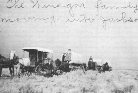
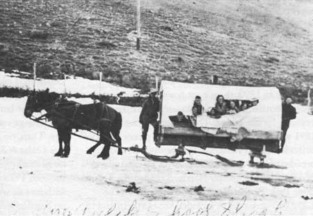
| The Winegar family were among the many settlers who poured into the valley between 1900 and 1920. This photograph, although poor in quality, shows the collection of wagons, possessions, and stock that homesteaders transported to their new home. Jackson Hole Historical Society and Museum |
The most intense period of homesteading in Jackson Hole occurred after 1900. Settlement peaked between 1908 and 1919, then declined as depressed agricultural prices and natural events such as the drought of 1919 discouraged further settlement. For all practical purposes, the homesteader's frontier ended in 1927, with a presidential executive order withdrawing virtually all public lands in Jackson Hole from settlement. [1] Only a few entrants received patents for land after this year.
Several characteristics distinguish homesteading in the valley after 1900 from the previous century. First, more homesteaders tried to farm the land exclusively, rather than devote their efforts to cattle ranching. Second, as the valley filled up, people settled more marginal lands. For example, after settlers acquired the best land in the Mormon Row area east of Blacktail Butte, others ventured north onto the sagebrush-covered land on Antelope Flats in 1910. [2] Third, after 1910, people filed preemption notices on lands that clearly were ill-suited for agriculture. Close scrutiny of specific cases reveals that the claimants took up homesteads to establish dude ranches, tourist facilities, residences, or quite simply to engage in real estate speculation.
Finally, government policies toward public lands altered dramatically after 1900. In the frontier West, the role of government was to transfer land and resources to private ownership in an orderly but expeditious way. The rise of the conservation movement in the late nineteenth century altered government policy and, consequently, government functions. New federal bureaus such as the Forest Service regulated and reserved lands and resources. The people of Jackson Hole felt this impact dramatically after 1900, when permits were required for timbering and grazing in the Teton National Forest. Resources remained available for use, but a new figure, the forest ranger, enforced limits, reducing the free-for-all on the public domain that characterized the previous century. [3]
The intensity of settlement transformed the valley after 1900. By 1909, the population of Jackson Hole had increased to an estimated 1,500 people according to the editor of the Jackson's Hole Courier. The United States Land Commissioner reported more than 150 "recent" entries in this period. The number of homesteads located on today's park lands more than doubled, supporting the general accuracy of statements in the Courier.
By the time the homesteaders' frontier ended in the 1920s, at least 5,280 acres in the area that now comprises the park had been plowed and cultivated. This figure represents the acreage cultivated while ranchers and farmers were proving up their properties. They no doubt continued to clear and plow new land, so 5,000 acres is very conservative. Cultivated land in the park may have approached 10,000 acres eventually, but there is no way to determine this figure accurately. Also, this acreage does not include land used for grazing. [4]
Homesteading in the park concentrated in three zones. Settlers preferred: (1) The valley east of the Snake River and north of the Gros Ventre River to Antelope Flats and (2) The Spread Creek Valley-Buffalo Fork area. The third zone—the valley west of the Snake River—was also homesteaded after 1900, though less intensely than the lands east of the river, and for different reasons.
Within the first zone, settlement advanced north from the Flat Creek area and Spring Gulch toward the Gros Ventre River. South of the river, near Grand Teton National Park's present south boundary, the Nickell family and Harvey Glidden's widow owned much of the acreage along the highway to the Gros Ventre. William Smith filed an entry as late as 1922. He tried to farm land on today's Elk Refuge, but failed in spectacular fashion. [5] Most land north of the Gros Ventre River to Menor's Ferry was preempted after 1901. Settlers primarily filed under the Homestead Act of 1862, which required five years of continuous residence and cultivation. Also, no less than 11 desert entries were filed in this area. The Desert Land Act was different from the 1862 law in two ways; there was no residential requirement and claimants paid $1.25 per acre. Since many could not spare the cash for a desert entry, they generally filed preemption papers under the 1862 law. Some of the people who settled in this area were Norm Smith, Charles Beagle, Birch Hopson, Frank Connell, John Coon, Marion Coon, Floyd Wilson, Roy Nipper, Frank Newbold, John Braddock, and Nephi Moulton. In addition, a surprising number of women filed preemption papers for tracts in this area, including Alma Moulton, Nellie Burton, Nora Bush, Elizabeth McCabe, Fannie Forrester, and Mary and Ann Lingenfelter.
Settlers filed for available parcels along the Gros Ventre River to Kelly, then moved north along the flats east of Blacktail Butte. Fred Lovejoy, who located a ranch on the north bank of the Gros Ventre River in 1899, added to his 320-acre ranch when his bride, Mary Lovejoy, filed a desert entry for 160 acres in 1908. Likewise, Cora Heigho Sebastian claimed a relinquishment, adding 160 acres to the Sebastian Ranch. A few others settled in this area before 1910, but the Sebastians and Lovejoys took up much of the floodplain along the north bank of the river.
In the Kelly area near the Gros Ventre, and along the foothills on the east side of Jackson Hole, homesteads blossomed. Virtually all of the homesteaders were married men with families, or single men aged 30 or over. Joseph Greenough was 70 years old when he filed final papers in 1912. Only James Williams, who homesteaded what is known today as the Hunter Hereford Ranch, was under 30. He had just turned 23 years old when he established his residence in May 1909. Only five settlers added acreage under the Desert Land Act, notably Bill and Sophie Kelly, who each filed a desert entry along the Gros Ventre. Kelly was a rancher and cattle buyer. Some of these homesteads were devoted to farming rather than ranching. Many were not very successful. William Binkley settled at what is now Kelly and part of the Teton Valley Ranch with his wife and four children in 1901. In five years, he managed to irrigate six acres. But Binkley was known more for his tusking and poaching than his green thumb. [6]

|
| Township 43 North, Range 115 West, 6th P.M. The earliest homesteaders claimed the best agricultural lands in the valley. One of the first "zones" of settlement was east of the Snake River, and north of the Gros Ventre River to Antelope Flats. This includes "Mormon Row." Once part of a much larger settlement, "Mormon Row" is today a small cluster of farms along the road that divides Sections 28 and 29. (Note: Patent dates denote when homesteaders actually received their patents, by which time they had already lived on the land for a number of years.) (click on image for an enlargement in a new window) National Park Service |
Jim Budge, James May, and Joe Henrie had settled southeast of Blacktail Butte prior to 1900. As more settlers moved into the area, homesteads concentrated east of Blacktail Butte. On July 1, 1908, President Theodore Roosevelt issued an executive order abolishing the Yellowstone National Forest and expanding the Teton National Forest. This executive order opened lands in the valley previously closed to homesteading. In September 1908, John and T A. Moulton located homesteads northeast of Blacktail Butte, after the release of the land from the forest reserve. Through December, others preempted the best lands in this segment of the valley. They were Thomas Murphy, Albert Gunther, Joseph Eggleston, George Riniker, and Henry May. One settler, Jake Johnson, may have anticipated the boundary change, for he filed his preemption papers nearly two months before Roosevelt's executive order. Holiday Menor homesteaded on the east bank of the Snake, opposite his brother's ferry. Eight others took up homesteads between 1909 and 1920. Since the majority of the settlers were Mormon, the area acquired the name Mormon Row sometime after 1910.
|
| In 1908, President Theodore Roosevelt opened up the area northeast of Blacktail Butte to homesteading. The May homestead was one of the first built in this area. Grand Teton National Park |

|
| In 1912, Thomas A. Moulton built this homestead north east of Blacktail Butte. Several Mormon families homesteaded in the area, which became known as "Mormon Row." Grand Teton National Park |
The land east of Blacktail Butte is comprised of an alluvial fan that provides very deep topsoil suitable for agriculture. Farmers and ranchers coveted land in this area, even though the lack of water for irrigation posed problems. [7] In 1910, as Mormon Row became settled, homesteaders expanded into more marginal lands on Antelope Flats. John Rutherford, Doc Steele, and Joe Pfeifer were the first to move into the sagebrush flats northeast of Blacktail Butte. Others filed preemption papers for lands along the floodplains and terraces east of the Snake River. Henry Gunther filed papers in 1914 and George Ferrel in 1915. [8]
The Buffalo Fork Valley-Spread Creek area experienced extensive settlement after 1900. A handful of homesteaders, such as Pierce Cunningham and Emile Wolff, had established cattle ranches in this area prior to 1900. However, the area remained isolated and largely unoccupied until 1908, when Roosevelt's proclamation altering national forest boundaries opened land. The proclamation generated a small-scale land rush. J. D. "Si" Ferrin was camped on String Lake when he learned of the newly opened lands. Knowing that he had his eye on a benchland of meadow south of the Buffalo Fork, his wife had dispatched a rider to tell him the news. Ferrin saddled his horse and made a beeline east across the Potholes to the Snake River, where he forded at a dangerous crossing. By the time his partner reached the benchland, Ferrin had already driven stakes on his claim. [9] Others who took up homesteads in this area in 1908 were Charlie Hedrick, Rudy Harold, John Dietz, and Joseph Bettendorf. In 1909, Bill Jump, J. B. Heniger, Anton Grosser, Otto Kusche, Jack Fee, Frank Coffin, and Orin Seaton homesteaded here. After 1910, nearly 20 other settlers located on the Spread Creek-Buffalo Fork country.
Although Cunningham, Wolff, and Uhl had added desert entries to their ranches, few newcomers filed papers under the Desert Land Act after 1900. Two reasons for this may have been a lack of money and available land. Few settlers arrived with a "start," or sufficient capital, to purchase desert lands even at $1.25 per acre. Further, the cost and time involved in constructing an irrigation system was prohibitive for some. Also, after 1908, homesteaders preempted much of the available acreage in the land rush, leaving little to add to a 160-acre parcel. [10]

|
| Township 44 North, Range 114 West, 6th P.M. Another major zone of settlement was the Buffalo Fork-Spread Creek area, located northeast of Antelope Flats. The Emile Wolff Ranch (No. 15) was patented in 1906. The Cunningham Cabin in Section 17 is all that remains of the Pierce Cunningham homestead claims (Nos. 31 and 32). (click on image for an enlargement in a new window) National Park Service |
In 1916, Congress passed and President Woodrow Wilson approved the Stock-Raising Homestead Act, which allowed individuals to preempt up to 640 acres of land considered suitable only for grazing. The law required no cultivation, only range improvements, whatever those might be. Two of Si Ferrin's sons took advantage of the act, filing stock-raising entries in 1920 and 1923 respectively. James McInelly filed for a 520-acre parcel in 1920. He secured a patent in 1925, grazing 260 cattle and horses on the ranch. In contrast, John MacDonald Graham staked out a stock-raising entry on Uhl Hill in 1928. Graham testified that he had not grazed any livestock on the entry and, as a result, a General Land Office inspector recommended denial of Graham's final proof papers. The recommendation was not followed, and Graham received a patent to the property in 1929. [11]
Settlement followed identical patterns along the Buffalo Fork River. Roosevelt's proclamation of 1908 released lands in the Buffalo Valley for occupation. Between 1909 and 1916, homesteaders claimed most of the land along the Buffalo Fork, in and adjacent to today's park boundaries. Only three desert entries were claimed and approved, probably for the same reasons that limited desert entries in the Spread Creek area.
Continuing northward, the terraces and flood plains along the Snake River between Pacific Creek and the original outlet of Jackson Lake provided a smaller area of concentration of homesteads. [12] There was little homesteading activity in this area until 1911, when a number of preemption papers were filed. Some homesteaders had worked on the construction of the Jackson Lake Dam in 1910-1911 and decided to stay. Joe Markham was a Reclamation Service employee who filed on a relinquishment in the Oxbow Bend area in 1914. Others were Herb Whiteman, who filed a gerrymandered claim on the flats north of Moran in 1915, and Charlie Christian, who took up 160 acres at Christian Pond in 1916. [13]
|
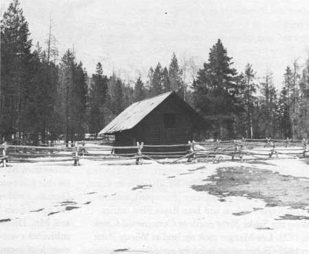
| Charlie and Delilah Hedrick homesteaded about three miles south of Spread Creek in 1908. Hedrick Pond marks the site of their homestead. National Park Service |
Much of the land north and east of the Moran area remained national forest land, therefore withdrawn from settlement. John Sargent's place on Jackson Lake was the only homestead patented in the north. Whiteman and the Heighos had abandoned the Lakeview Ranch by 1900, while Sim Edwards never received a patent to his ranch on Lizard Creek. [14] Peter Mulligan had a homestead in the Jackson Lake area, but he must have squatted on the property, for no patent exists and its location remains obscure. On the terraces along Pacific Creek, a few scattered homesteaders proved up small ranches after 1910; they were Elmer Arthur in 1913, Harold McKinstry in 1916, Frank Bramen in 1917, and William Snell in 1918. William Thompson filed preemption papers on 160 acres located at the outlet of Two Ocean Lake in 1914. On Pilgrim Creek, Samuel R. Wilson homesteaded a tract in 1916, attempting to establish a small ranch. David Ferrin also filed papers on an isolated parcel on Pacific Creek near the present park boundary. Agricultural uses were limited mostly to cattle grazing on forest lands, alloted by the Forest Service through a permit system. [15]
Although less concentrated than the other two homesteading zones, settlement also increased in the valley west of the Snake River after 1900. Small ranchers and homesteaders moved north from Wilson into this area. Between 1901 and 1910, August Nikolaison, Charles Carlson, Frank Waterman, Charles Ilse, and Paul Lyon preempted 160-acre tracts along the narrow stretch between the timbered benches and the Snake River. William Grant took up 160 acres below the Sawmill Ponds in 1914, which later became the first Moose Post Office. The area is comprised of old stream channels and alluvium consisting of sandy and gravelly loams. [16]
Others filed entries to establish the first dude ranches in the valley. Louis Joy took over Dave Spalding's relinquishment to establish the JY Ranch at the base of Phelps Lake in 1907, which Struthers Burt described as "absolutely useless for ranching purposes." [17] Harold Hammond and Tucker Bispham, an eastern dude, each took up 160-acre parcels and formed a partnership. Originally intending to go into the cattle business, they decided to switch to dude ranching after the First World War in 1919. This became the White Grass. Harry Clissold started the Trail Ranch in 1916, when he filed on 160 acres north of the White Grass. Cliff Ward took up 160 adjacent acres in 1922, which were incorporated into the Trail Ranch. [18] Several homesteaders filed for 640-acre tracts in the 1920s under the Stock-Raising Act of 1916. Henry Stewart added 637 acres to the JY through this act in 1925. Two dude wranglers and cowboys, Lewis Fleming and Shadwick Hobbs, filed stock-raising entries in 1926 near the JY. Their patents were approved in 1929. [19]
Two land entries may well have been motivated by real estate speculation. Geraldine Lucas purchased just over 38 acres on Phelps Lake under the Homestead Act of 1820. Since she had homesteaded several miles north on Cottonwood Creek, there seems to be no other explanation for this entry. In 1925, Hannah Porter filed and received title to 160 acres of timberland west of the JY through the Timber and Stone Act of 1878. This legislation provided a way for private interests to purchase timber lands. Land unfit for any sort of cultivation could be purchased through a negotiated sale with the government. Porter purchased the acreage for $1,260. [20]
Another group of homesteaders preempted lands along Cottonwood Creek from Menor's Ferry to Jenny Lake. For more than a decade, Bill Menor had the west side of the Snake River to himself, until James Manges filed preemption papers on a 160-acre tract near the confluence of Taggart and Cottonwood Creeks in 1911. Manges had set out from Colorado for Oregon. He arrived in Jackson Hole in the fall of 1910, hoping to make a side trip through Yellowstone. Too late, he learned that Yellowstone's roads had shut down because of snow. He wintered with the Worts in South Park, then followed Wort's advice to homestead on Taggart Creek.
A year later, Struthers Burt and Horace Carncross each filed on 160 acres located on the west bank of the Snake River, north of Cottonwood Creek. They also added 160-acre desert entries; the 640-acre ranch formed the headquarters of the Bar BC, a prominent dude ranch in Jackson Hole. Dudes and employees of the Bar BC often then became homesteaders themselves, including Tucker Bispham, who moved to the White Grass. Struthers Burt persuaded Alfred and Frank Bessette from Princeton, New Jersey, to work as chefs at the Bar BC. Both took up homesteads in 1914 and 1915 near the Manges place. Bryant Mears, a Bar BC dude, took up residence on a relinquishment above Menor's Ferry, apparently attempting to set himself up as a gentleman rancher at his Sun Star Ranch, now known as the 4 Lazy F Ranch. Others who attempted to set up small ranches were Jack Canfield in 1914, Norm Bladon in 1914, Harry Sensenbach in 1914, and May Horel in 1915. [21]

|
| Township 43 North, Range 116 West, 6th P.M. The area west of the Snake River was settled later, and less intensely. This map depicts the homestead patents in Township 43 North, Range 116 West, which is directly west of the township shown in previous map. William Menor had the first homestead (No. 19) in this area, which he selected for its suitability as a ferry crossing rather than its agricultural potential. (click on image for an enlargement in a new window) National Park Service |
Farther up Cottonwood Creek, Geraldine Lucas preempted a homestead in 1913. Although she cultivated some acreage, her intent was to build a retirement home. She added 80 acres through a desert entry. A friend of Lucas's, Naomi Brewster Colwell, filed papers on an adjacent parcel around 1916. Moritz Locher was the first to homestead at Jenny Lake, taking over a relinquishment at Lupine Meadows in 1915. [22]
After Burt and Carncross established the Bar BC, individuals preempted lands for the express purpose of starting dude ranches. Buster Estes filed on a 76-acre tract on the west bank of the Snake River in July 1922, which became the STS. Peter Karppi preempted 160 acres of terrace and benchland on Cottonwood Creek in 1922, starting the Half Moon Dude Ranch. At Jenny Lake, Tony Grace filed an entry in October 1922 on property that became the Danny Ranch. [23] Karppi and Grace had acquired lands that had been withheld from settlement by a withdrawal of nearly 20,000 acres in Jackson Hole under the Carey Irrigation Act of 1894. This law enabled the Secretary of the Interior to donate up to 1,000,000 acres to specific arid states, on the condition that the states sponsor the settlement, irrigation, and reclamation of desert lands. Most states chose to contract with private companies to develop irrigation systems. Several companies took advantage of the law to secure water rights in Jackson Hole. In 1916, the state of Wyoming applied for a withdrawal of land and water rights on Jenny and Leigh Lakes. Called the Jenny's and Leigh's Lakes Project, the application withdrew 19,378 acres of land from settlement, which included virtually all public lands between township line 43 north all the way to township line 46 north, just south of Two Ocean Lake. Ostensibly, the company would irrigate the withdrawn lands, then sell acreage to prospective farmers and ranchers. In effect, however, this application shut down homesteading in Jackson Hole north of Blacktail Butte. Valley residents smoldered with anger and resentment as no progress was made to solve the issue for several years. No ditches were constructed, and it became clear that three companies, the Teton Irrigation Company, the Osgood Land and Livestock Company, and the Utah-Idaho Sugar Company, intended to secure water rights and sell the water to users in other areas such as Idaho. [24]
|
| Manges Cabin. When Jim Manges homesteaded at Taggart Creek, Bill Menor was the only settler on the west side of the Snake River in this area. More settlers soon followed, most starting dude ranches. Manges eventually built tourist cabins on his property. National Park Service |
In 1921, the Secretary of the Interior rejected the state's application for the land withdrawal. Complications delayed the release of these lands for several months but, finally, over 19,000 acres were reopened for settlement, effective March 29, 1922. [25] This initiated a new flurry of homesteading. Hoping to duplicate the success of the Bar BC, Buster Estes, Peter Karppi, and Tony Grace preempted lands in 1922. Roger Carlson and Ivan Bayse filed entries along the Snake River north of Cottonwood Creek in 1922. Lee Manges took up land at Windy Point in 1925. They homesteaded for agricultural purposes. Along the Snake, Joe LePage, the head wrangler and a partner of the Bar BC, purchased a relinquishment on a 640-acre stock-raising entry from Slim Armstrong in 1924. Ed K. Smith, nicknamed "Roan Horse," homesteaded a 160-acre ranch at Lupine Meadows in 1921, a relinquishment with a cabin already on site. [26]
Speculators also used homestead laws to establish tourist facilities in the area. Homer Richards filed an entry on 160 acres southeast of Jenny Lake. He grazed livestock on 18 acres, but wrote in his final proof papers that his homestead included a gas station, barbershop, and rental cabins. Harrison Crandall filed a stock-raising entry on 120 acres north of Jenny Lake Lodge in 1924. To comply with the law's requirements, he grazed about 40 head of horses on the land each summer and seeded about 25 acres to brome grass. He began a photography business, and constructed the studio that is presently located at the south end of Jenny Lake. Albert W. Gabbey filed two stock-raising entries east of Crandall's, one in 1924 and the other in 1927. Gabbey secured a patent to the first entry in 1932. His second preemption was denied by the General Land Office and became the subject of controversy when the decision was linked to park extension and Rockefeller's Snake River Land Company. The Secretary of the Interior ordered the issuance of a patent in 1940. Gabbey established the Square G Dude Ranch. [27]
East of Jenny Lake, H. C. Ericcson filed a homestead entry on floodplain and terrace lands on the west side of the Snake River near Deadman's Bar in 1926. He added a 442-acre stock-raising entry in 1929, establishing a cattle ranch. Ericsson was an attorney from Lawrence, Kansas, who sought and purchased property in the valley for the purpose of real estate speculation. [28]
General Land Office inspectors investigated the homestead application of Evelyn Dornan, who filed on a small 20-acre tract east of the Snake River across from Menor's Ferry in 1922. This was a small lot that had been passed over by earlier settlers. Mrs. Dornan, a widow from Pennsylvania, learned about the parcel from Holiday Menor. With her teenage son, Mrs. Dornan established residence in 1923 and cultivated a one-acre truck garden, harvesting 500 pounds of potatoes and 500 pounds of cabbage. However, the small acreage attracted the attention of land office inspectors when she submitted final papers in 1925. The next year, C. S. Dietz inspected her homestead. He found that Mrs. Dornan had complied with residency and cultivation requirements, even though the acreage was too small to provide a sufficient income from farming. Dietz recommended the issuance of a patent, concluding that Evelyn Dornan had acted in good faith. [29]
Many Jackson Hole homesteaders were mature adults with families, who had moved several times in search of a new beginning. Charlie Hedrick was born in Illinois and raised in Colorado, before he came to Jackson Hole in 1904. John Woodward followed the old Oregon Trail from Nebraska to Oregon in a covered wagon in 1898. He returned to Wyoming in 1902, crossing Teton Pass, and lived in Lander, Dubois, and Riverton before homesteading near Kelly, Wyoming, in 1912. John Simpson settled in 1892 on what became the town site of Jackson, after following the miner's frontier to Colorado in the 1850s and Deadwood, Dakota Territory, in the 1870s. William Lafferty, a Civil War veteran, settled in Nebraska, South Dakota, and Cody, Wyoming, before locating a ranch far up the Gros Ventre in 1900. Frank Lasho, who settled on the east bank of the Snake River near Moose, was 39 years old and had a wife and child when he relocated in the valley. Illness prevented Will Steingraber from residing on or improving his homestead entry near "Fort Pier" or Pierre, South Dakota. So at age 32, he and his family started over, filing an entry near the Buffalo Fork in 1914. Milton H. Kneedy came to Jackson Hole in 1910 after losing a flour mill in Kansas, when his partner, reputedly a Baptist minister, absconded with his money. [30]
|
| Spring Gulch ranch kids traveled to school in this makeshift "wagon-bus." Carl George is the driver. Jackson Hole Historical Society and Museum |
A significant segment of Jackson Hole's settlers were foreign immigrants. Frederick Sandell and Norm Bladon were Englishmen who homesteaded in the Menor's Ferry area. Gerrit Hardeman and Hannes Harthoorn left the Netherlands after 1900, drawn to Jackson Hole by the promise of land. Hardeman built up one of the finest ranches in the valley. Joe LePage was a top-notch wrangler from Canada, who worked his way from employee to partner at Burt and Carncross's Bar BC. He started his own ranch, but died a premature death in 1927. Otto Kusche, who listed his nationality as "foreign" on his final proof papers, homesteaded what became the headquarters of the Elk Ranch. He was probably German, as were his neighbors, Anton Grosser and John Dietz. John P. "Pete" Nelson, born in Denmark, and Gottfried Feuz, a Swiss national, homesteaded in the Spread Creek area in 1911. Both raised large families whose descendants live in the valley today. To many immigrants, who left land-poor countries, the risks of homesteading in the American West were trivial when compared to realizing the dream of owning a farm or ranch. [31]
Overall, nearly 400 homestead entries were filed and approved for lands within today's park boundary, totaling thousands of acres. Water, soil types, and the homesteader's intentions influenced the patterns of settlement in the valley. The first settlers, who were essentially ranchers, claimed the best lands along rivers and creeks. They cultivated and irrigated hay fields to grow the necessary winter feed for their cattle. The Gros Ventre, Buffalo Fork, Snake, and Spread, Ditch, and Cottonwood Creeks were important water sources. Lands comprised of loamy soils of floodplains, terraces, and alluvial fans were settled first and most intensely.
Understanding the motives of homesteaders is critical to comprehending the settlement patterns in Jackson Hole. Most established small cattle ranches of which farming was a significant element. After 1900, some optimists devoted their energy to farming alone. Some homesteaded to provide a residence, while they earned their livings in other ways. Bill Menor took up his homestead to use the single channel of the Snake River for a ferry operation. Beginning with Louis Joy and the JY in 1907, entrepreneurs preempted lands for the purpose of dude ranching. Homesteaders in the Jenny Lake area during the 1920s also took advantage of the growing tourist trade. But, as much as any of these factors, federal land policy, mandated by congressional laws, impacted homesteading in the valley.
Prior to 1890, there were few restrictions on the public domain. Virtually all resources and lands were available for the taking. The Forest Reserve Act of 1891 was one of the most significant pieces of legislation in conservation history. The law allowed the president to set aside forest reserves by executive order. President Benjamin Harrison created the Yellowstone Park Timber Reserve in March 1891. The 1,239,040-acre reserve included the northern end of Jackson Hole, closing the area to settlement. John Sargent managed to secure a patent in the northern end of the valley only because he filed his preemption papers in July 1890, less than a year before the creation of the reserve.
In 1897, President Grover Cleveland issued a proclamation setting aside 829,440 acres under the Teton Forest Reserve. The reserve included much of the public domain in Jackson Hole. Land north of township line 42 north was closed to settlement. Then, on July 1, 1908, President Theodore Roosevelt signed a proclamation establishing Teton National Forest, comprising 1,991,200 acres. The proclamation reopened for settlement lands in the valley, but reserved the Teton Range and most of the highlands surrounding the valley. From Washington, D.C., Roosevelt could hardly have known that he generated a small-scale land rush in this isolated mountain valley. [32]
Water development projects influenced settlement in the valley, particularly lands reserved by authority of the Carey Irrigation Act of 1894. The Teton Irrigation Company tied up lands for several years; the water appropriated to irrigate farms and ranches in the valley was sold to irrigation companies in Idaho. In 1916, the State of Wyoming applied for a withdrawal of 19,378 acres for Jenny's and Leigh's Lakes, also known as the "Jennies and Lees Lake Segregation." The Interior Department denied the application in 1921, and most of the land was reopened for settlement in 1922. But for five years, the project withheld considerable acreage from settlement. [33]
Five years later, President Calvin Coolidge issued a series of executive orders that closed the public domain in Jackson Hole to settlement. Executive Order 4631 closed several hundred acres to entry "pending determination as to the advisability of reserving the lands for elk-refuge purposes." Most of this acreage was located in the area of today's elk refuge. Then, on July 7, 1927, Coolidge signed Executive Order 4685, which closed thousands of acres to homesteading. Three subsequent closures were issued between 1928 and 1930. The purposes of the later withdrawals were not specific and, as a result, stirred up considerable controversy. Valley residents learned several years later that the July 1927 withdrawal was connected to the purchase program of John D. Rockefeller Jr.'s Snake River Land Company. But, that is another story. [34]
| <<< Previous | <<< Contents >>> | Next >>> |
grte/hrs/hrs8.htm
Last Updated: 24-Jul-2004