
|
Texas Bureau of Economic Geology
Down to Earth at Tuff Canyon, Big Bend National Park, Texas |
ON THE CANYON FLOOR
You will walk upstream once you're on the canyon floor, because you'll want to do your close inspection of the canyon's geology as you retrace your steps downstream. "Why not pay more attention to the rocks as I walk upstream?" You may wonder. It's because if you start at the upstream end of the hike, you will be able to follow events in the rocks in sequence, from oldest to youngest. The rocks are faulted and gently tilted so that the oldest layers are at the east end of the path, and the younger ones are closer to the canyon mouth. It is easier to understand (and tell) the story if we proceed from early to late events.
Start walking eastward (upstream) until your progress is slowed by large masses of dark rock. Here is where we stop and begin to look at the rocks carefully. This dark rock is one of many lava flows making up the Bee Mountain Basalt, and it is underlain by breccia and pillow lava. The breccia consists of lava fragments in a much finer matrix; the lava cooled quickly when it flowed into water and was shattered into fragments by steam explosions as the water absorbed heat from the lava and boiled violently (fig. 13). Pillow lavas form during less violent encounters between lava and water; the pillows are smooth, round masses (fig. 14) held together by thin skins of lava that quickly cooled against water. The skins remained soft enough to bend, and they provided enough insulation that the hot interiors of the pillows cooled more slowly. As a result, a pillow could sag and mold itself around underlying pillows. Pillow lavas are the most widespread volcanic features on Earth; they cover enormous areas on the ocean floors.

|
| Figure 13. Breccia produced by steam explosions where basalt lava flowed into water, Tuff Canyon. Pen (center) for scale. |

|
| Figure 14. (a) Lava pillow in breccia, Oamaru, New Zealand. Pen for scale. (b) Pillows, Oamaru, New Zealand. Hammer for scale. (c) Pillows, Badsvellir, Iceland. Pen for scale. |
The breccia and pillow lava are two results of lava flowing into a body of standing water. Geologists are sure that this body of water was not a shallow arm of an ocean because the youngest fossils of ocean-dwelling animals in the sedimentary rocks of Big Bend National Park are about twice as old as the 34-million-year-old basalt. Fossils younger than 65 million years in this region record only critters that lived on land or in shallow lakes or rivers. Perhaps ponds formed where streams were dammed by basalt lava flows. Later basalt lava, arriving at the water's edge, formed breccia and lava pillows until all the water was displaced or evaporated. Still later, basalt lavas formed more massive (unbroken) flows as they moved over dry ground. The top surface of the dark basalt lava, directly below the pyroclastic rocks, is decorated by a network of pale veins. These had to have formed when pyroclastic material from the later rhyolite eruptions lodged in cracks in the already old and weathered basalt.
On the south edge of the canyon floor, west of the east observation platform, a large block of basalt has preserved the original surface of a lava flow (fig. 15). Although the block is not in its original position after being tumbled downstream by floodwaters, it does show some significant features that are worth a closer look. The lava flow top is smooth to gently rolling or bulging and spotted by elongated holes (fig. 16). The holes were formed by gas bubbles that rose through the hot liquid lava but were caught in the cooler skin of the flow and then stretched into long shapes as the lava flow continued to move. These ancient holes that were formed by trapped bubbles are called vesicles.

|
| Figure 15. Lava with original flow surface preserved, Tuff Canyon. |

|
| Figure 16. Close-up of surface of lava in figure 15, showing stretched gas bubbles (vesicles). |
Now how did this scene come to be? Let's do a little detective work. The basalt and breccia, at least 33 feet thick, do not reveal whatever rock lies under them, so the older history of the Tuff Canyon rocks remains hidden. But you can see that directly overlying the basalt are pyroclastic-surge deposits containing channels that run roughly east-west. The surge deposits also contain ballistic blocks with impact sags (fig. 17). The ballistic blocks are all basalt, although basalt was only a passive victim of the explosions, not a cause of them. The basalt was old and cold by the time rhyolite magma approached the Earth's surface, resulting in volcanoes that erupted explosively to form pyroclastic deposits in this part of the park. Some basalt had even become weathered and eroded, judging from the rounded basalt fragments in the overlying pyroclastic deposits and from the pyroclastic-filled cracks in the upper part of the basalt. These rounded chunks of basalt had their corners and edges smoothed long after the basalt cooled and were not molten blobs or bombs when they were thrown out. From the shape of its impact sag, we can make a rough estimate of the direction from which a ballistic block came. And from the size of a block, we can calculate the maximum distance from the volcanic vent to the impact site. The vent for these blocks was probably north or east of Tuff Canyon and less than 2 miles away. Note that some of the rock fragments in the Tuff Canyon surge deposits overlap one another like shingles on a roof. This imbrication indicates motion from the northeast to the southwest, in agreement with the evidence from the impact sags.

|
| Figure 17. (a) Ballistic block of basalt with an impact sag (a dent or crater in the underlying layers) in a pyroclastic-surge deposit, Tuff Canyon. The smaller, dark, rock fragments in this photo did not make impact sags because they were swept along the ground in a surge cloud, but the biggest one fell in on a steeper trajectory after being blown out of a volcanic vent. (b) Ballistic block with an impact sag in a surge deposit under the dry waterfall of figure 4. The block is about 10 inches in diameter. |
But why are the layered deposits interpreted as products of pyroclastic surges? Good question. The strongest evidence is that fragments of pumice and basalt as much as 2 inches in diameter were dumped side by side in a single layer in spite of their density differences. The density of basalt is about three times that of pumice, which can sometimes even float on water. These fragments could therefore not have been carried or dumped by water, but by something having a density much lower than that of either basalt or pumice. That something was most likely a fast-moving cloud of gas, dust, and rock fragments. The cloud or surge moved with hurricane force over the land surface, although it may have been only a few feet deep. Some big rock fragments were deposited without impact sags, having been swept into the surge along with smaller particles. However, some blocks right beside these big fragments do have impact sags, and these show that explosions were occurring at the same time as these layers were being deposited. Chunks of basalt, torn from older layers as the rhyolite magma approached Earth's surface and exploded, flew in an arc through the air, thudded into surge deposits that had just stopped moving, and finally became buried by more surge-carried particles.
See the pumice-rich pyroclastic-flow deposit lying above the surge deposits? Let's get a closer look.
Turn around and begin retracing your route back down the canyon floor. About 50 feet downstream from the basalt lava with the stretched vesicles, a fault has dropped the rocks on the west by at least 50 feet. The pyroclastic-flow deposit that lies at the top of the south wall, directly under the east observation platform, is at the level of the canyon floor on the west side of the fault. Looking at this rock layer closely, you can see that it is a pyroclastic-flow deposit composed mostly of lapilli of silky pumice between 0.1 and 0.8 inch in diameter, along with less abundant rock fragments of many types (basalt, other lavas, and, more rarely, limestone). Some of these fragments may have been picked up as the pyroclastic flow moved along the ground; others were blown out when the vent cleared its throat.
Above the pyroclastic-flow deposit is a surge deposit less than 3 feet thick, containing rock fragments less than 0.4 inch to 4 inches in diameter. The surge deposit is overlain by an unstratified, very poorly sorted debris-flow deposit about 6 feet thick, containing rock fragments reaching 20 inches in diameter. That deposit in turn is overlain by a pyroclastic-flow deposit about 16 feet thick, and above this lies another surge deposit. Pyroclastic flows are more tightly controlled by topography than are surges because the denser flows tend to move down valleys, whereas surge clouds can billow out of valleys and cover neighboring highlands.
As you walk downstream toward the cross canyon, look for more faults exposed in the canyon walls. Many have displaced the rock layers on either side by only a few feet. Compare what you see in the canyon walls with the generalized sketch in figure 18. Look how quickly you have learned how to tell pyroclastic-flow, -surge, and debris-flow deposits apart! About 425 feet downstream from the basalt, the canyon floor widens into the cross arms that you saw from the parking area, but you should continue walking downstream, toward the canyon mouth. The surge and debris-flow deposits are close to the floor of the canyon. Look for ballistic blocks with impact sags.

|
| Figure 18. Sketch showing distribution of four kinds of deposits in south wall of Tuff Canyon. For simplicity, the floor of the canyon is shown as being smooth and level; in reality it slopes gently but unevenly to the southwest. |
About 80 feet downstream from the west observation platform, a fault in the north wall of the canyon shows displacement of about 6 feet, down to the northeast. At and below eye level you can see gas escape pipes (fig. 19) in the pyroclastic-flow deposit in the north wall just west of the fault. These are approximately vertical, about 3 feet high and a few inches wide, and spaced a few inches to 3 feet apart. These pipes cut upward through several flow units, which average less than 1 foot in thickness and which are distinguished by a coarser pumice concentration at the top of each flow unit. Why are the bigger pieces at the top? Why didn't they sink to the bottom of each flow unit? The explanation in terms of physics is complex, so let's use an analogy instead; if you shake a container of mixed nuts, the larger ones (such as Brazil nuts) rise to the top not because they are lighter than the others, but because the bigger pieces go to the surface where they can move more freely without bumping into others.
|
| Figure 19. Gas escape pipes cutting through thin flow units in a pyroclastic-flow deposit, Tuff Canyon. The pipes are the vertical dark streaks. The height shown is about 6.5 feet. |
What can we deduce about the flow units? They were probably not deposited after separate volcanic eruptions. Instead, they record unsteady but continuous flow, and all accumulated within a relatively short time (otherwise a gas escape pipe would be cut off abruptly at the top of a flow unit). The reasoning goes this way: observations of explosive eruptions show that pyroclastic-flow and -surge deposits can accumulate very rapidly, thickening at rates of feet per second. If the lower flow units were old enough to be cool, gas would not still be escaping from them after the upper flow units were deposited. Instead, a gas escape pipe would begin and end within a single flow unit. This evidence, that the pipes cut upward through more than one flow unit, is important because it suggests that all the pyroclastic deposits preserved in the walls of Tuff Canyon may have formed in hours or, at most, a few days.
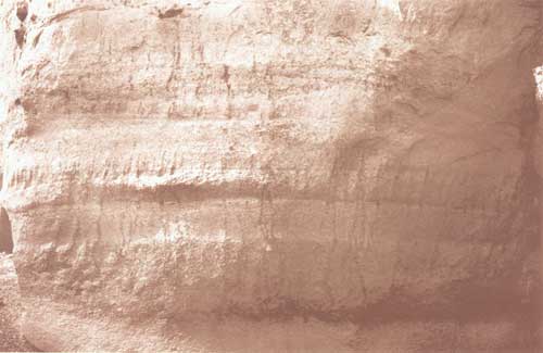
In this section of the canyon, also notice the case hardening on the higher parts of the walls (fig. 20). There, rainwater percolating through pumice has dissolved some of the volcanic glass. The dissolved silica was carried downward in the water and then was deposited when the water evaporated, leaving a harder crust on the surface. This more resistant coating forms the rock draperies that decorate the upper walls of Tuff Canyon.

|
| Figure 20. Case hardening has formed rock draperies on the surface of a pumice rich deposit in a wall of Tuff Canyon. The height shown is about 13 feet. |
About 150 feet west of the gas escape pipes, a mesquite tree clings to the north wall, its root system partly exposed (fig. 21). This tree probably started growing on the canyon floor, which has since been lowered about 13 feet by erosion. This unusually rapid rate of down-cutting by a stream records perhaps the effects of overgrazing by cattle from about 1900 until the 1940's. When herds removed much of the vegetation in the upper valley of Blue Creek, rain that could not soak into the soil ran off, causing greater water discharge through streams and more rapid erosion.

|
| Figure 21. Mesquite tree clinging to the north wall of Tuff Canyon. The original ground surface on which the tree started to grow was about 13 feet above the present-day canyon floor. That's my wife Rosemary Barker 5'8" in the foreground to indicate scale. |
In the cliff by the mesquite tree, the top of the pyroclastic flow is only about 1 foot above the canyon floor, and surge and debris-flow deposits make up most of the canyon walls. Just to remind you, we have looked at the rocks while walking downstream because faulting and tilting of the layers have brought progressively younger layers to your eye level. We end the tour by looking at some of the youngest features.
About 160 feet west of the clinging mesquite tree, near the mouth of Tuff Canyon and on the south wall about 10 feet above the floor are some smoothly rounded potholes (fig. 22). Some of these contain pebbles or cobbles. The potholes were cut into the soft pyroclastic-surge deposits when sand and gravel swirled in eddies at the edge of a flooded stream. After the potholes formed, the canyon was cut deeper by later floods, leaving the potholes above the reach of floodwaters. No modern potholes are visible in the floor of the canyon, probably because the sand and gravel there are moved by each flood.

|
| Figure 22. Potholes near the mouth of Tuff Canyon. The lowest pothole is about 1.5 feet wide. |
Well, it's time to head on back. You can return to the parking area via the trail out of the canyon (see the map at the back of the book). It's uphill, so take your time.
| <<< Previous | <<< Contents >>> | Next >>> |
state/tx/2000-DE02/sec7.htm
Last Updated: 03-Aug-2009