
|
North Dakota History
Geology of the North Unit, Theodore Roosevelt National Memorial Park |
GEOLOGIC PROCESSES IMPORTANT IN FORMATION OF LAND FORMS IN THE PARK
There are two geologic processes making land forms in the North Unit which deserve more than passing mention. These are slumping on a large scale and fluted weathering of the butte sides. Neither of these processes is peculiar to this area only but they have played important parts in the formation of its scenery.
Slumping
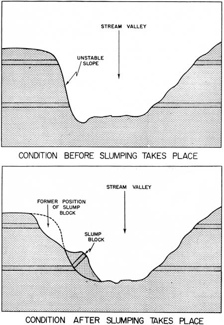
Slumping is due to unstable conditions of the sides of the hills. This unstable condition may be created a number of ways but here apparently it was due to oversteepening of the banks by the stream cutting at the bottom of the bank. When water falls as rain on this unstable slope, it sinks in and adds weight to the already unstable part thus increasing its instability. The water also tends to lubricate the planes or surfaces along which the slipping will later take place.
|
| FIGURE 6. Diagrams showing conditions before and after slumping takes place. |
When the block gets too heavy, it finally starts to move. It may move very rapidly or it may and probably does move quite slowly. In any event, the strata in the block which has moved are frequently little disturbed in the movement except to cause them to be tilted into the bank. This type of slumping gives rise to a kind of topography known as hummocky topography as it is so irregular. An excellent example of this can be seen at the Sperati or furthest west overlook on the North Unit Park road as well as many other places in the Park.
|
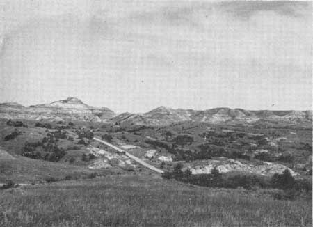
| FIGURE 7. General view looking east across the slump area in Section 33, T. 148N., R. 99W. Note the hummocky nature of the topography accented by the growth of juniper trees. |
Fluted weathering or rivulet erosion
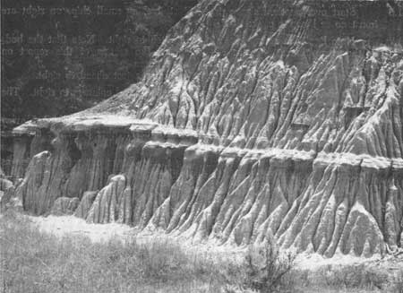
The sides of many of the buttes can be seen to be extremely gullied or minutely dissected by running water. Unless you were present here during a rain, you actually would never see water running down these little gullies. This type of erosion produces forms which are spoken of, rather incorrectly perhaps, as fluted weathering. More correctly, it should be called rivulet erosion.
|
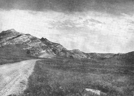
| FIGURE 8. Closer view of the slump area in Section 33, T. 148N., R. 99W. The beds in the slump block to the left dip into the hill at an angle of roughly 45 degrees. |
Apparently, the way this process works is that sheetwash running more or less uniformly off the sides of the butte tends ultimately to concentrate into tiny gullies due to initial irregularities of the slope. After they are established, these tiny rivulets tend to remain and grow with each rain.
As they grow, they cut back into the butte until finally two rivulets meet at their heads. The divide between them is now very narrow and more subject than ever to fast wearing away by erosive action. Finally this divide between the two rivulets is entirely cut through and thus a small portion of the butte side is separated from the main butte. Thus the butte is destroyed little by little by the action of running water and at the same time by separating small parts off the main butte in this fashion the sides of the butte tend to remain quite steep and at approximately the same angle with the horizontal.
This type of erosion is most common in arid or semi-arid regions where the slopes are poorly protected by plants. It is also a characteristic of areas where the rainfall tends to come in large amounts in short spaces of time. In other words, this type of topography is most commonly seen in arid or semi-arid areas where there is little plant cover to protect the land surface from torrential downpours.
|
| FIGURE 9. View of fluted weathering or rivulet erosion in a poorly consolidated sand in the NW/4 NE/4 Section 31, T. 148N., R. 99W. |
| <<< Previous | <<< Contents >>> | Next >>> |
state/nd/1956-23-2/sec5.htm
Last Updated: 28-Mar-2006