|
California Division of Mines and Geology
Bulletin 182 Geologic Guide to the Merced Canyon and Yosemite Valley, California |
THE GEOLOGY, GEOMORPHOLOGY, AND SOILS OF THE SAN JOAQUIN VALLEY IN THE VICINITY OF THE MERCED RIVER, CALIFORNIA
By RODNEY J. ARKLEY
Lecturer and Specialist in the Agricultural Experiment Station
Department of Soils and Plant Nutrition
University of California, Berkeley, California
The Merced River emerges from a V-shaped gorge through the Sierra Nevada foothills into the San Joaquin Valley at the ghost town of Merced Falls, 30 miles east of Turlock. From this point it flows west-southwest for a distance of 40 miles, where it joins the northwestward-flowing San Joaquin River. On either side of the river is a series of geomorphic surfaces rising in steps to the north and south almost 500 feet above the river (figs. 1, 3). The two oldest and highest of these land forms are pediments carved on a consolidated deposit of andesitic tuff. The younger land forms are the surfaces of a series of alluvial fans and related depositional stream terraces. The nature of these surfaces and associated geologic formations was first studied and reported briefly by the author in connection with the soil surveys of eastern Merced and Stanislaus Counties (Arkley 1954, 1959). In these studies clear-cut relationships were established between land forms, geologic formations and soil series. Subsequently the conclusions drawn with respect to the geology and geomorphic history of the area have been largely substantiated by geologic investigations of Davis and Hall (1959) and Hudson (1960). These geologists used the work of the author extensively in their studies, although some differences in interpretation remain.

|
| FIGURE 1. Schematic section (N-S) 3 miles west of Merced Falls. |
Most of the exposed rocks of the area are poorly consolidated Cenozoic sediments, and all except the oldest are nonmarine. The structure of the rocks is simple. The Tertiary rocks are tilted westward throughout the area; the older Quaternary sediments are tilted slightly westward on the west side of a fault zone located about 10 miles east of Turlock. A summary of the formations and related soils found in the area is given in table 1. The distribution of the rocks exposed at the surface is shown in figure 2.
Table 1*.
| Formation | Age | Dominant lithology | Maximum thickness |
Dominant soil series |
| Alluvium | Recent | Granitic sand over gravel | 50 | Grangeville, Tujunga |
| Sand dunes | Late Pleistocene and Recent | Fine sand | 30 | Delhi |
| Modesto | Late Pleistocene | Granitic sand over stratified silt, sand | 100 | Hanford, Dinuba |
| Riverbank | Middle Pleistocene | Granitic sand over stratified silt, sand | 200 | San Joaquin, Snelling |
| Turlock Lake | Early Pleistocene | Granitic sand over stratified silt, sand | ]800 | Montpellier, Whitney, Rocklin |
| North Merced (New) (Arroyo Seco?) | Early Pleistocene | Pediment gravel (mainly metamorphic) | 30 | Redding, Corning |
| China Hat (New) | Late Pliocene | Pediment gravel (mainly metamorphic) | 50 | Redding (acid variant) |
| Mehrten | Early, middle Pliocene | Andesitic tuff and gravel | 1,200 | Pentz, Peters, Raynor |
| Valley Springs | Late Miocene | Rhyolitic ash, clay | 270 | Amador |
| Ione | Middle Eocene | Sandstone clay | 200 | Hornitos |
| (Several formations) | Late Cretaceous | Marine sandstone, shale | 9,500 | In wells only; not exposed |
| Late Jurassic | Slate | unknown | Daulton, Whiterock | |
| Late Jurassic | Meta-andesite | unknown | Auburn |

|
| FIGURE 2. Geology of the San Joaquin Valley in the vicinity of Merced River. (click on image for a PDF version) |
PRE-CENOZOIC
The oldest rocks of the area shown on the map (fig. 2), designated as bedrock complex, are strongly folded meta-andesite and slate. These rocks are described by Clark in the section of this guidebook entitled Summary of the pre-Tertiary geology of the Western Sierra Nevada metamorphic belt. Cretaceous rocks are not exposed in the area but underlie the valley, thickening westward from a feather edge about 12 miles west of the bedrock foothills to a thickness of 9,500 feet under the west side of the valley.
CENOZOIC
Ione Formation. Resting unconformably on the bedrock complex are the Eocene sandstone and kaolinitic clay of the Ione formation described by Allen (1929). The sandstone has attractive hues of pink, yellow, red, and gray and has been quarried for building stone. This material is described as a fluvial and shoreline marine deposit and contains fossils of Venericardia planicosta at the Planicosta Buttes just south of the bridge at Merced Falls. The formation dips about 3° to the west and disappears under more recent sediments a mile or two west of the bedrock foothills. The shallow, acid Hornitos sandy loam is the only soil mapped on this formation.
Valley Springs Formation. The Valley Springs formation rests unconformably on the Ione sandstone. It consists of a fluvial sequence of rhyolitic ash, sandy clay and siliceous gravel. The material is acidic in reaction (pH 4.5 to 5.0) and pale yellow to white in color. The formation is generally considered to be of Miocene age, although Axelrod (1944) considers it to be Mio-Pliocene in age. This rock is exposed in an area only about a mile wide parallel with the mountains, just west of the Ione formation. The distribution of the shallow; acid Amador soil coincides exactly with that of the Valley Springs formation.

|
| Photo 1. Ione formation dipping 5° W.; hard sandstone capping kaolinitic clays. Recent alluvium in the foreground. View is toward the north. |
Mehrten Formation. The Valley Springs is conformably overlain by the Mehrten formation, an easily recognizable sequence of dark sandstone, conglomerate and claystone beds of late Miocene and Pliocene age, according to Stirton and Goeriz (1942). The material is always more than 50 percent andesitic and often as much as 95 percent andesitic. The formation dips westward with a slope of about 100 feet per mile and thickens to a maximum of 1,200 feet under the center of the valley. It contains beds of moderately hard mudstone which stand out on eroded slopes as prominent ledges, giving rise to "haystack mountains" such as China Hat, a conical peak visible southwest of Merced Falls.

|
| Photo 2. Mima mound or "hog wallow" microrelief and Amador soil formed on Valley Springs formation south of Merced Falls. View is toward the south. |
The Mehrten in the area shown in figure 2 contains few or none of the volcanic mudflows found farther north in the Sierra Nevada, but consists almost entirely of fluvial material reworked from the volcanic deposits. As indicated in the section Geomorphology of Yosemite Valley in this guidebook, there is no source of Mehrten formation in the Merced River drainage; its southernmost source was in the headwaters of the Tuolumne River. Therefore the Tuolumne River or some distributary of it must have flowed southward in Mehrten time, and forced the Merced River to a southerly course downstream from Merced Falls. The Mehrten formation weathers easily and gives rise to three distinct dark-gray soils high in montmorillonite—the Pentz, Peters, and Raynor series; the last named is about 3 feet deep.

|
| Photo 3. "Haystack" hills formed by the erosion of alternately hard and soft beds of the Mehrten formation. Pentz soils on the hill sides; Peters clay on the gentle slopes in the foreground. Three miles north of Snelling. |
China Hat Pediment and Gravels. The China Hat pediment, named by Hudson (1960) is an old erosion surface truncating the Mehrten formation. The only remnant of this surface is the high, flat-topped ridge south of the Merced River. It is 1 or 2 miles in width and extends 9 miles west of its easternmost preserved point southwest of Merced Falls. The surface slopes westward from a high point 750 feet in altitude at 45 to 68 feet per mile. The pediment is mantled with a 20- to 40-foot layer of gravel, consisting largely of 2- to 6-inch pebbles and cobbles of vein quartz, quartzite and other hard metamorphic rocks eroded from the foothills of the Sierra Nevada. The pebbles, except for the quartz and quartzite, are strongly weathered; some are completely decomposed.
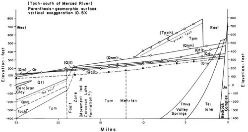
The China Hat pediment is clearly post-Mehrten, therefore younger than mid-Pliocene. Studies of remnants of a similar surface in Stanislaus County indicate that the China Hat pediment pre-dates the Tuolumne Table Mountain lava flow which has been dated as late Pliocene or early Pleistocene by Taliaferro and Solari (1949). Therefore, the China Hat surface is assigned a late Pliocene age. The relatively steep gradient of the China Hat pediment (fig. 3) suggests that it was tilted during the last major uplift in the Sierra Nevada, and this also is in agreement with a late Pliocene age for the pediment. Hudson (1960) attempts to relate this land form to the Broad Valley stage of Matthes (1930), but a direct connection cannot be found through the lower foothills. A correlation with the Mountain Valley stage seems more probable, but more work is needed to establish the relationship.
|
| FIGURE 3. Schematic cross-section (E-W) north of Merced River. (click on image for a PDF version) |
The surface of the China Hat gravel is red, acid (pH 4.5-5.0), infertile soil with an iron-silica cemented hard-pan, an acid variant of the Redding soil series. It has a pronounced micro-relief of "hogwallows" or Mima mounds which are the result of the activity of pocket-gophers (Arkley 1954).
North Merced Pediment and Gravels. On both sides of the Merced River and also south of the remnant of the China Hat pediment are remnants of another broad westward-sloping erosion surface mantled with 10 to 20 feet of gravel similar to the China Hat gravel. This pediment has an altitude of 500 feet at Merced Falls, of 220 feet 18 miles to the west. Its gradient is much less than that of the China Hat pediment and decreases westward from 22 to 15 feet per mile. The pediment truncates the Ione, Valley Springs, and Mehrten formations, and is thought to be of the same age as the Arroyo Seco pediment identified by Gale et al. (1939) 40 to 70 miles to the north. Soil surveys indicate that the surface is well represented in the intervening area. Gale considered the Arroyo Seco pediment to have formed after the last important uplift of the Sierra Nevada. The evidence in this area is in agreement with this idea. The soil formed on the North Merced gravel is the Redding series similar to that formed on the China Hat gravel, but is less acid and infertile. This soil is also mapped on the Arroyo Seco gravel to the north.
Turlock Lake Formation. The Turlock Lake formation is a fan deposit of dominantly granitic alluvium covering the westward extension of the North Merced pediment and resting directly on Mehrten formation where the North Merced gravel had been eroded away between North Merced and Turlock Lake time. The uppermost layer of this formation is a coarse sand from 10 to 30 feet thick which has been weathered to form the Montpellier soil, with a thick red, sandy clay loam subsoil. This layer is underlain by a light gray, thinly laminated deposit of silt and very fine sand 10 to 40 or more feet in thickness. Logs of wells drilled in the Turlock Lake formation and a few outcroppings indicate that at least one buried red soil similar to the Montpellier soil formed from coarse sand lies beneath the silty layer. This weathered sand is in turn underlain by silty material. This clear-cut repeated sequence of silty material overlain by decidedly coarse sand (1-4 mm) was not brought out by Davis and Hall (1959) because of an unfortunate choice of type section. The relationship was quite evident during the soil-survey investigations. Shallow, weakly developed Whitney soil of fine sandy loam texture and Rocklin soil with a thin silica-cemented hardpan are found where erosion has exposed the silty material. The strongly weathered buried soil at the top of the lower sequence suggests that the Turlock Lake formation was actually laid down during two periods of deposition separated by a long interval of weathering.

|
| Photo 4. Undulating surface of the Turlock Lake formation with Montpellier coarse sandy loam soil. Twelve miles northeast of Turlock. |
Within the Turlock Lake formation is a wedge of blue, diatomaceous lacustrine clay which was correlated by Davis and Hall (1959) with the Corcoran clay of Frink and Kuess (1954) (fig. 3). Davis and Hall place this "blue clay" within the Riverbank formation (1959, pl. 4) based upon its position well below a "red clay" layer 100 feet beneath the town of Turlock. This red layer was assumed to be the surface soil of the Riverbank formation. However, the westward extension of the surface of the Turlock Lake formation coincides with this layer, while the Riverbank surface is actually encountered within 10 feet of the surface at Turlock. Therefore the Corcoran clay is a member of the Turlock Lake formation (fig. 3).
Riverbank Formation. The Riverbank formation covers the western extension of the Turlock Lake formation and also extends eastward through it to the bedrock foothills as a depositional river terrace in a valley entrenched through the older formations. This material is clearly younger than the Turlock Lake formation, and has a similar but less clear-cut lithologic sequence of fine material capped with coarse sand. The dominant soil on the coarse sand is a moderately developed brown soil (the Snelling series) and on the fine-textured and stratified sandbeds is a reddish-brown soil (the San Joaquin series) and a brown soil (the Madera series), both with strongly cemented silica hardpans.

|
| Photo 5. Riverbank surface with San Joaquin hardpan soils in the foreground; Turlock Lake surface an hilltops in the background. View is north from East Avenue, 8 miles east of Turlock. |
Modesto Formation. The Modesto formation buries the westward extension of the Riverbank formation and also extends eastward to the foothills through the older formations as a depositional river terrace. The sequence of laminated silty material capped by sand evident in the Turlock Lake formation is clearly repeated in the Modesto formation. These materials are only slightly weathered with either no subsoil development (Hanford soil) or a very weakly developed subsoil (Greenfield and Dinuba soils). These soils are only slightly leached and are among the most fertile in the state. In the vicinity of Turlock and south into Merced County, the sand has been reworked into dunes by wind action (figure 2).
Alluvium. The Merced River crosses the Pleistocene formations in a flat-floored valley bordered by bluffs 40 to 60 feet high. The valley is underlain by alluvium which consists chiefly of granitic material of fine sandy-loam texture. Where the river has cut down to the Mehrten formation, the lower part of the alluvium consists of coarse gravel with pebbles and cobbles of granitic and metamorphic rocks. These gravels have been dredged for gold, resulting in the large piles of gravel tailings along the Merced River. The river has been widening its floodplain in this area (figure 2). This suggests that a new era of pediment cutting has begun in recent time.
GEOMORPHIC HISTORY
On the basis of the soil-survey investigations and the work of Davis and Hall (1959) and Hudson (1960), the sequence of events in the Turlock-Merced Falls area is interpreted to have been as follows:
1. Erosion of the Eocene Ione formation into a surface of strong relief was followed by deposition of the Valley Springs and the Mehrten formations which flooded the valley during Mio-Pliocene times with a thickness of 800 feet at Merced Falls, and nearly 1,500 feet in the center of the valley.
2. The China Hat pediment was cut by the Merced River or by local streams flowing across the Mehrten and was mantled with metamorphic gravel derived from the Sierra Nevada.
3. Tilting and uplift of the Sierra Nevada extended westward into the valley increasing the gradient of the China Hat pediment from an estimated original 20 feet per mile to the present 45 to 68 feet per mile. Accelerated stream flow resulted in the erosion of most of the pediment.
4. As the streams approached a more stable gradient, the North Merced (Arroyo Seco?) pediment was formed and mantled with gravel derived from metamorphic rocks.
5. In late Pliocene or early Pleistocene time, renewed erosion resulted in the destruction of a portion of the North Merced pediment and incision of the river to a lower level.
6. At the beginning of the glacial epoch, glacial flour in the form of silt and very fine sand was deposited in the valley, forming the lower portion of the Turlock Lake formation. As glacial activity died out, the coarse sand layer was deposited. This sequence of events was apparently repeated at least once in Turlock Lake time, with an intervening period of weathering of considerable duration.
Corcoran Lake appears to have existed in the valley during a period of rapid subsidence west of Turlock during the deposition of the Turlock Lake formation.
7. Following a period of erosion and further entrenchment of the river, renewed deposition of glacial outwash gave rise to the Riverbank formation.
8. The Modesto formation was deposited in a similar fashion during the last glacial period.
9. In recent time the river has entrenched the Pleistocene formations to a depth of 20 to 60 feet, and, like the Tuolumne River to the north, has widened its floodplain in the eastern portion of the area where the river bed rests upon the Mehrten bedrock.
10. Subsidence of the valley west of a fault zone 12 to 18 miles west of the foothills continued until late in the Pleistocene and resulted in tilting the Turlock Lake and older formations slightly westward.

|
| Photo 6. The Yosemite Falls in April. Photo by Mary Hill. |
References
Allen, V. T., 1929, The Ione formation of California: Univ. California, Dept. Geol. Sci. Bull., v. 18, p. 347-448.
Arkley, R. J., 1954, Soils of eastern Merced County, California: Univ. California, College of Agr. Soil Survey no. 11, 174 p.
Arkley, R. J., 1954, The origin of Mima mound (hogwallow) micro-relief in the far western states: Soil Sci. Soc. of America Proc., v. 18, no. 2, p. 195-199.
Arkley, R. J., 1959, Soils of eastern Stanislaus County, California: Univ. California College of Agr. Soil Survey no. 13, 197 p.
Axelrod, D. I., 1944, The Pliocene sequence in central California: Carnegie Inst. Washington, Pub. 553, p. 207-224.
Davis, S. N., and Hall, F. R., 1959, Water quality of eastern Stanislaus and northern Merced Counties, California: Stanford Univ. Pubs., Geol. Sci., v. 6, no. 1, 112 p.
Frink, J. W., and Kuess, H. A., 1954, Corcoran clay, a Pleistocene lacustrine deposit in the San Joaquin Valley, California: Am. Assoc. Petroleum Geologists Bull., v. 38, p. 2353-2571.
Gale, H. S., Piper, A. M., and Thomas H. E., 1939, Geology and ground-water hydrology of the Mokelumne area, California: U. S. Geol. Survey Water-Supply Paper 780, 230 p.
Hudson, Frank S., 1960, Post-Pliocene uplift of the Sierra Nevada, California: Geol. Soc. America Bull., v. 71, p. 1547-1575.
Matthes, F. E., 1930, Geologic history of the Yosemite Valley: U. S. Geol. Survey Prof. Paper 160, p. 1-37.
Stirton, R. A., and Goeriz, H. F., 1942, Fossil vertebrates from the superjacent deposits near Knights Ferry, California: Univ. California Dept. Geol. Sci. Bull., v. 26, p. 447-472.
Taliaferro, N. L., and Solari, A. J., 1949, Geology of the Copperopolis quadrangle, California: California Div. Mines Bull. 145 (map only).
| <<< Previous | <<< Contents >>> | Next >>> |
state/ca/cdmg-bul-182/sec3.htm
Last Updated: 03-Aug-2009