|
California Division of Mines and Geology
Bulletin 182 Geologic Guide to the Merced Canyon and Yosemite Valley, California |
SUMMARY OF THE PRE-TERTIARY GEOLOGY OF THE WESTERN SIERRA NEVADA METAMORPHIC BELT, CALIFORNIA*
By LORIN D. CLARK
U.S. Geological Survey, Menlo Park, California
*Publication authorized by the Director, U.S. Geological Survey.
Metamorphic rocks of the western Sierra Nevada near the Merced River are of Jurassic and Paleozoic age. They are on the west limb of a faulted synclinorium, the central part of which is occupied by the Sierra Nevada batholith. Parts of the eastern limb are preserved in the eastern part of the Sierra Nevada and in the White and Inyo Mountains still farther east. The metamorphic rocks strike northwest, as reflected in the map pattern of lithologic units (pl. 1), and nearly everywhere dip steeply eastward or are vertical. The metamorphic rocks are divided into three structural blocks by the Melones and Bear Mountains fault zones (Clark, 1960). The structure within each block is generally homoclinal with younger beds to the east, but the gross distribution in the metamorphic belt as a whole has been reversed by fault movement, for the youngest metamorphic rocks are in the western fault block and the oldest in the eastern block. Dominant strike-slip movement along the Bear Mountains and Melones fault zones is suggested by steeply-plunging minor folds and b-lineations within the zones. The stratigraphic separation along the Melones fault zone near the Merced River is at least 10 miles, and the stratigraphic separation along the Bear Mountains fault zone farther north exceeds 3 miles. Because the dihedral angle between bedding and faults is small, the net slip along the fault zones must be much greater than the stratigraphic separations.
|
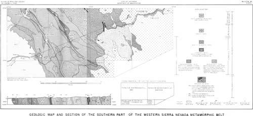
| Plate 1, Geologic map and section of the southern part of the western Sierra Nevada metamorphic belt, accompanies this paper. (click on image for a PDF version) |
The Paleozoic rocks, which are entirely east of the Melones fault zone in the area of plate 1, are all included in the Calaveras formation. The lower part of the formation, exposed near Bagby, consists largely of phyllite derived from siltstone, but contains some interbedded tuff and graywacke and sparse lenticular limestone. These are overlain by metavolcanic rocks, derived mostly from coarse andesitic breccia but in part from pillow lava and tuff. From Briceburg northeastward to the large horseshoe bend in the Merced River, the Calaveras formation consists largely of black phyllite derived from siltstone but contains thin-bedded metachert, sparse limestone lenses and, in the upper part, intraformational conglomerate.
From the horseshoe bend eastward the black phyllite persists, but metachert constitutes a considerable part of the section, lenses of limestone and dolomite are larger and more abundant, and lenses of mafic metavolcanic rocks are common. The age of the Calaveras formation near the Merced River is based upon H. W. Turner's identification of Fusulina, which he considered to be of Carboniferous age, from a locality a few miles southwest of El Portal (1893, p. 309). No fossils other than crinoid debris have been found in the lower part of the formation. Because of shearing of parts of the Calaveras formation east of Briceburg, its thickness cannot be determined accurately, but it is almost certainly more than 25,000 feet, and it may be more than 50,000 feet thick.
Mesozoic rocks, consisting of complexly intertonguing metavolcanic and metasedimentary strata, constitute the central and western fault blocks and occur in the eastern fault block east of Bear Valley. The Mariposa, Consumnes, and Logtown Ridge are among the named formations. The metavolcanic rocks were derived chiefly from tuff and volcanic breccia of intermediate composition, but in part from basaltic lava, some with pillow structure, and in part from felsic lava and pyroclastic rocks. The metasedimentary rocks were derived largely from siltstone, but graywacke and mixed-pebble metaconglomerate constitute much of some sections. Metamorphosed chert and cherty shale are abundant locally. Both the sedimentary and volcanic rocks accumulated in deep water for graded beds are common in both tuff and graywacke throughout the region. Marine fossils found in both metavolcanic and metasedimentary rocks are of Late Jurassic (Callovian to Kimmeridgian) age. Everywhere in the western Sierra Nevada the Jurassic strata are truncated by faults or erosion—the section in the central fault block along the Merced River is nearly 18,000 feet thick and is among the thickest preserved.

|
| Photo 1. Interbedded metachert and black carbonaceous phyllite of the Calaveras formation of Paleozoic age near the Geologic Exhibit marker. These beds are little folded, but nearby are intricately folded strata. Photo by U.S. National Park Service. |
Two groups of plutonic rocks intruded these metamorphic rocks during Late Jurassic time and one group in middle-Cretaceous time. The first was an ultramafic group, now represented mostly by serpentine, and the second a group ranging from diorite to granodiorite. In middle-Cretaceous time, according to radiometric data obtained by Curtis, Evernden, and Lipson (1958, p. 7-9), the Sierra Nevada batholith was intruded. Rocks of the batholith are described by F. C. Calkins and D. L. Peck elsewhere in this guidebook.
Uplift and perhaps gentle folding occurred in the Sierra Nevada region between about middle Permian and middle Jurassic time, but most of the deformation of both Paleozoic and Mesozoic strata occurred during Late Jurassic and possibly Early Cretaceous time. The synclinorium was formed in Late Jurassic time, before intrusion of the older series of granitic rocks, and resulted in the northwest strike and steep dip of Mesozoic and Paleozoic strata. Axes of folds formed during this deformation plunge northwest and southeast at angles of less than 30°. The second major deformation also began before emplacement of the older granitic rocks, but possibly continued into the Early Cretaceous. The major faults, pervasive shearing of the eastern block, and steeply plunging minor folds and lineations resulted from the second major deformation.
References
Clark, L. D., 1960, Foothills fault system, western Sierra Nevada, California: Geol. Soc. America Bull., v. 71, p. 483-596.
Cloos, Ernst, 1932, Structural survey of the granodiorite south of Mariposa, California: Am. Jour. Sci., 5th ser., v. 23, p. 289-304.
Curtis, G. H., Evernden, J. F., and Lipson, J., 1958, Age determination of some granitic rocks in California by the potassium-argon method: California Div. Mines Special Rept. 54, 16 p.
Turner, H. W., 1893, Some recent contributions to the geology of California: Am. Geologist, v. 11, p. 307-324.
Turner, H. W., and Ransome, F. L., 1897, Description of the Sonora quadrangle [California ]: U. S. Geol. Survey Geol. Atlas, Folio 41.
| <<< Previous | <<< Contents >>> | Next >>> |
state/ca/cdmg-bul-182/sec1.htm
Last Updated: 03-Aug-2009