
|
California Division of Mines
Special Report 68 Igneous and Metamorphic Rocks of the Western Portion of Joshua Tree National Monument, Riverside and San Bernardino Counties, California |
INTRODUCTION
IGNEOUS AND METAMORPHIC ROCKS OF THE WESTERN PORTION OF JOSHUA TREE NATIONAL MONUMENT RIVERSIDE AND SAN BERNARDINO COUNTIES, CALIFORNIA*
JOHN J. W. ROGERS
*Based upon a dissertation submitted in partial fulfillment of the requirements for the degree of Doctor of Philosophy, Division of Geological Sciences, California Institute of Technology, Pasadena, California; manuscript submitted to the Division of Mines for publication February 1955. Publications of the Division of the Geological Sciences, California Institute of Technology, Pasadena, California—Contribution No. 832.
Purpose. From June, 1953 to August, 1954, the writer carried on a study of the textural features in the igneous rocks exposed in Joshua Tree National Monument south of Twentynine Palms, California. In the course of this investigation, observations were made on the general geologic nature, age relations, structural features, and mode of formation of the crystalline rocks throughout the western part of the Monument. The object of the present paper is to summarize the field and petrographic information obtained in this study without burdening the reader with extensive textural detail.
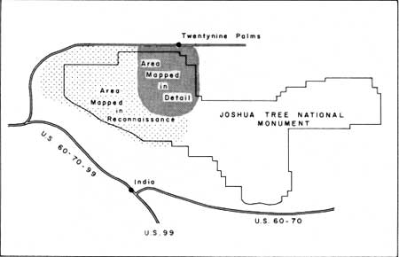
Location. The location of Joshua Tree National Monument and the area dealt with in the present work are shown in figure 1. The index map also distinguishes between the portion of the area studied in detail and the portion covered only in reconnaissance fashion.
Most of the area shown in figure 1 lies in the Little San Bernardino Mountains, a northwesterly trending range which makes up the northeastern border of the Coachella Valley. Extending east from the Little San Bernardino Mountains, and partly included in the map area, are the Pinto and Hexie Mountains. The northern edge of the area mapped is marked by the Pinto Mountain fault (Hill, 1928), an east-west fault cropping out about a quarter of a mile north of the mountainous region.
|
| Figure 1. Index map. |
Physiography. Joshua Tree National Monument occupies part of a broad mountainous belt which trends east-west across southern California. Much of the Monument has an elevation of 4,000 feet or more, and both on the north and the south the mountains exhibit steep scarps rising from the surfaces on either side of the area.
Within the western portion of the Monument are a number of separate mountain ranges and intervening valleys which are shown on the geologic map. The Little San Bernardino Mountains comprise the southwestern portion of the map area and are underlain largely by the Pinto gneiss or its migmatized derivatives (as are most of the other mountain ranges in the area). The southern face of the range is probably a fault scarp. The range extends in a west-northwesterly direction and thus makes an angle of approximately 45 degrees with the gneissic foliation in the area. The Lost Horse Mountains extend north from the Little San Bernardino Mountains and may be the topographic expression of a gneissic screen between two bodies of the White Tank quartz monzonite. The Hexie Mountains consist of a mass of Pinto gneiss which extends east from the Little San Bernardino Mountains and whose topographic expression may be partly the result of movement along the Eagle Mountain fault at the southern edge of the range. As the name suggests, the Pinto Mountains also consist largely of the Pinto gneiss, which strikes in the regional north to northwesterly direction and dips steeply. On the north, the range is bordered (at least in part) by the Pinto Mountain fault, and the southern face of the mountains may also represent a fault scarp separating the range from the Pinto Basin. South of Twentynine Palms a mountainous mass extends to Queen Mountain and is underlain largely by the Palms quartz monzonite. Both lithologic and topographic evidence suggest that the southern face of Queen Mountain is a fault scarp.
The valleys separating the mountain ranges mentioned above may be subdivided into two categories. The first type includes Pleasant Valley and the Pinto Basin (just to the east of the map area), both of which are underlain by an unmeasured thickness of alluvium. Pleasant Valley is almost certainly bordered on the north by the Eagle Mountain fault, and the Pinto Basin may also be a topographic unit as a result of faults along one or more sides. Not all valleys, however, may be attributed to faulting or are underlain by large quantities of alluvium, and a second type of valley is formed on broad outcrops of the White Tank quartz monzonite and results from the fact that the jointed, disintegrated quartz monzonite shows far less resistance to erosion than do any of the other rocks in the area. Intrusive contacts between gneiss and remnants of the quartz monzonite high on the slopes of the Pinto, Hexie, and Lost Horse Mountains indicate that the relief is not caused by faulting along the contact between the two rocks. Valleys in the quartz monzonite (such as Queen and Lost Horse Valleys) characteristically contain numerous monoliths of the rock separated by a surface of loose sand derived from the quartz monzonite. Each monolith is cut into many large joint blocks, and the resulting grotesque appearance has led to such descriptive names as "Wonderland of Rocks" and "Jumbo Rocks." The western part of Lost Horse Valley is underlain by Unit C of the Palms quartz monzonite rather than by the White Tank quartz monzonite, but the two rocks are texturally and compositionally so similar that they exhibit almost identical topographic features.

|
| Photo 1. View east across Lost Horse Valley toward the Lost Horse Mountains. On Ryan Mountain (in background) dark Pinto gneiss is intruded by light White Tank quartz monzonite. In middleground typical outcrop of jointed White Tank quarts monzonite in Lost Horse Valley. Area of Ryan Campground in foreground. Photo courtesy National Park Service. |
|
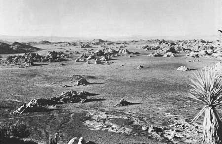
| Photo 2. view south across Indian Cove Campground. Rounded outcrops in foreground ore typical exposures of jointed White Tank quartz monzonite. Photo courtesy National Park Service. |
It is interesting to note that the north-south drainage divide for the Monument extends over a broad and nearly flat area of the White Tank quartz monzonite just south of Queen Valley rather than along the crests of the ranges north or south of this outcrop.
Mountain fronts, whether formed by faulting or differential erosion, are universally steep. Slopes of thirty degrees are common in many places. On the south face of Queen Mountain, over-steepening has proceeded to such an extent that landsliding has occurred, and small talus slopes are present in other parts of the area. Canyons cut into the mountains are almost invariably "V-shaped" and steep-sided.
South of the Pinto Mountain fault a number of pediments have been developed at the base of the steep mountain front near the northern edge of the Monument. The most extensive cutting has occurred on the granitic rocks, namely the White Tank quartz monzonite and Unit C of the Palms quartz monzonite. The pediments are marked by small remnant knobs of quartz monzonite and are characteristically covered by a veneer of gravel several feet thick.
At the mouths of canyons along the southern face of the Little San Bernardino Mountains, small fans have formed. Many of these fans have been incised, apparently by the same streams that formed them, and it is not certain whether the present streams are eroding or constructing the fans. Also undetermined is the extent to which the slopes south of the Little San Bernardino Mountains and away from the major canyons have been formed by deposition of fans. Fans also have been built, in some places, next to the mountain front on the north side of the Monument.
Within the Monument the change from valley floor to mountain face is characteristically abrupt, and small fans or pediments have developed locally. Small pediments cut on White Tank quartz monzonite bedrock may be seen along the sides of many of the gneissic mountain ranges. Streams on these pediment surfaces have cut into bedrock at depths of only a few feet below a veneer of gravel.
One interesting feature shown at many places in the Monument is the difference in rates of erosion exhibited by the relatively coarse-grained White Tank quartz monzonite and the fine-grained aplite dikes that intrude it. The quartz monzonite is far more disintegrated than the aplite and almost invariably is eroded more rapidly than the aplite. Dikes commonly project beyond the surface of the quartz monzonite on all outcrops where both rocks are present. The ability of fine-grained rocks to resist disintegration and erosion is also demonstrated by the fact that the aphanitic olivine basalt which comprises Malapai Hill stands as a resistant knob above the quartz monzonite which it intrudes.
|
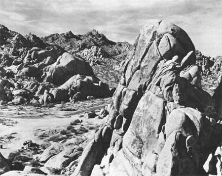
| Photo 3. Wonderland of Rocks; view northwest from Lost Horse Mountain. Weird surface formed by weathering of White Tank and Palms quartz monzonites. Photo courtesy National Park service. |
Natural arches occur at several places in outcrops of the White Tank quartz monzonite. Commonly the arches appear to follow curved joint surfaces, below which the disintegrated rock has been removed.
Procedure. Mapping in the area south of Twentynine palms, (in the vicinity of the White Tank quartz monzonite), was done on aerial photographs obtained from the U. S. Air Force, photographic Records and Services Division, which covered part of the region designated by the Air Force as the Pine Knot Area. Mapping in the remainder of the western part of the Monument was done on maps compiled by the Engineering Branch of the National Park Service. The map published with this paper is compiled largely from the writer's own work, but is also adapted partly from the work of Miller (1938) and Maclellan (1936).
Acknowledgments. Most of the work discussed in this paper was done as a Ph.D thesis project at the California Institute of Technology, and the writer would like to thank the staff of the Geology Department for their much-needed assistance. Especial thanks must be given to Dr. Ian Campbell, who supervised the project. The writer is also extremely grateful to the staff of the National Park Service in Joshua Tree National Monument for their permission to work in the Monument and for their invaluable assistance in the field.
| <<< Previous | <<< Contents >>> | Next >>> |
ca/cdm-sr-68/intro.htm
Last Updated: 18-Jan-2007