
|
Geological Survey 18th Annual Report (Part II)
Glaciers of Mount Rainier Rocks of Mount Rainier |
ICE EROSION OF AN ISOLATED, CONICAL MOUNTAIN.
The study of the manner in which the topography of Mount Rainier has been modified by ice erosion has suggested certain general principles which control the sculpturing of an isolated mountain peak sufficiently lofty to be crowned with perennial snow and to give origin to glaciers. Although these conclusions were reached after detailed studies of individual glaciers and of the topographic changes resulting from long-continued ice erosion, it is convenient in describing the glaciers of Mount Rainier to have in mind at least the general laws governing their distribution and behavior.
The geology of Mount Rainier and its present general form show that when in its greatest perfection it was a conical mountain, with gracefully concave sides. The upper portion of the mountain is formed to a large extent of fragments thrown out during explosive eruptions. Lava flows are also abundant, but did not greatly modify the character of the slope as determined by the falling of projectiles shot out of the summit crater. The primitive form was that of a typical scoria and lapilli cone of the character of Fusiyama, Japan, and other conical volcanic piles which still retain their youthful perfection of form.
Whether or not Rainier was truncated before the glaciers had greatly modified its lower slopes is unknown, but the truncation was not sufficient to have much influence on the character of the glacial mantle formed about it. In either case the height of the mountain—between 15,000 and 16,000 feet before the explosion that truncated its summit, and about 14,500 feet after that event—insured the gathering of perennial snows and the formation of névé fields and glaciers on its more elevated portions without an intervening period of weathering and stream erosion. The main topographic changes that have resulted must therefore be due to glacial action and to the eroding power of streams fed by the melting of the ice.
The weathering of rock masses unprotected by snow and ice has also assisted in the work of deforming the once symmetrical peak. Climatic conditions similar to those to which Mount Rainier is now exposed would lead to the covering of the mountain above an elevation of about 10,000 feet with a sheet of perennial snow. The snow would change to the condition of a névé, which would give origin to glaciers. Assuming that the peak was originally a perfectly symmetrical cone with smooth, even sides, and that the névé formed a uniform covering over the upper third of its surface, the downward flow of the névé would be equal in all directions. The spreading of the ice as it flowed down the cone, a progressively greater area being covered by it as it descended, would insure equal melting, except so far as that might be influenced by the unequal amount of heat reaching the southern and northern sides of the peak, and would either thin away uniformly in all directions or be gathered into local streams.
Many disturbing conditions come in, however, in the case of a peak like Mount Rainier, composed of loose agglomerate and lava sheets. Irregularities in the surface of the cone, erosion by streams flowing from the ice, unequal drifting of the snow as well as unequal melting owing to variations in exposure on the northern and southern sides, etc., would lead to the gathering of the descending ice into more or less well-defined streams. Individualized ice streams once established would hold their position and by their erosion would sink deeper and deeper into the rocks. From the extremity of each glacier a stream fed by the melting ice would carve a gorge or canyon leading to rivers on the plain below. As the ice gathered in well-defined streams melting would be retarded and the glaciers consequently extended farther and farther down the water-cut gorges. In this manner what maybe termed primary glaciers would originate from the dividing of the descending névé.
Below the horizon where the primary glaciers divide the ice erosion would be confined to comparatively narrow channels, and would cut radiating trenches in the sides of the mountain. Excavation would be continued below the extremities of the glacier by the streams flowing from them, and the valleys would there be narrower than in their ice-filled depressions higher up. As the glaciers deepen their beds they sink into the mountain and are more completely sheltered from the sun, thus tending to perpetuate their own existence. Between the primary glaciers there would be portions of the lower slopes of the mountain left in relief by the excavation of the valleys between them. These V-shaped masses pointing up the mountain would form wedges against which the descending névé would divide to form primary glaciers. The Wedge and Little Tahoma are typical examples of such wedges.
The surfaces left as V-shaped masses between the primary glaciers when the division occurs above the snow line, or when a climatic change causes the perennial snow to descend lower on the mountain's sides, would become covered with snow fields, which would give origin to secondary glaciers. Interglacier, below The Wedge, and the small glaciers on the back of the V-shaped mass of which Little Tahoma is the culminating point, are examples of these secondary glaciers, or interglaciers, as they may be termed, after the typical example just mentioned.
The interglaciers excavate valleys and cut back amphitheaters, so that the surface of the original V-shaped mass between any two primary glaciers becomes hollowed out, leaving rocky crests along their sides. The ridges bordering the primary glaciers converge upward, and, uniting, form wedges, which, crumbling under the attacks of the destructive agencies of the air, become broken into pinnacle or other forms, the details in their sculpturing depending on the nature of the rock. The original V-shaped masses left by the intrenching of primary glaciers thus become skeleton forms, their borders and high, wedge like, upward-pointing extremities alone projecting above the snow, except when the summer melting is far advanced.
As is well known, the erosive action of a glacier, other conditions being the same, depends on the gradient of its bottom. The abrasion of the bed of a normal alpine glacier increases from its terminus with increase of gradient up to a certain point, and then, if then gradient still increases and approaches the vertical, becomes less and less. The gradient that insures greatest erosion is not definitely known. It varies with the amount of débris with which the ice is charged, as well as with other conditions, but is apparently in the neighborhood of 300. This law has an important bearing on the topographic changes that an isolated glacier-covered mountain passes through. Judging from the present condition of Mount Rainier and other similar isolated peaks on the Pacific coast, it appears that the most intense erosion occurs in a zone about half a mile broad, where then primary glaciers become distinct ice streams. In this zone the glaciers excavate canyons and thus increases the slope of the central mass of the mountain above the extremities of the V-shaped residual masses on its lower slopes. The heads of these valleys tend to become amphitheaters.
As has been shown, especially by Willard D. Johnson, of the United States Geological Survey—the results of whose studies, however, are not yet fully published—the cliffs encircling an amphitheater in which a glacier has its source gradually recede, owing to the disintegration of the rocks in the great crevasse, termed a bergschrund, which is formed near where the upward-sloping névé meets the rock walls inclosing it. The rocks in the bergschrund are shattered by changes in temperature and by the freezing of water in their crevices and interstices, and the loosened fragments are plucked out by the outward flow of the névé snow. The bergschrunds are filled with snow each winter and reopened the following spring. This process leads to an energetic sapping of the bases of the cliffs and a consequent recession of their walls. The faces of the cliffs encircling an amphitheater or cirque are commonly too steep to admit of the accumulation of snow upon them, but allow it to fall in avalanches and to be blown away. The cliffs, being bare of snow, are exposed to changes of temperature and are wind-swept. These various destructive agencies assist in the extension of the amphitheater toward the summit of the mountain, and also in its general enlargement.
The primary glaciers excavate deep, steep-sided valleys, but accomplish little toward altering the profile of an isolated peak as it appears when beheld from a distance. The even slopes of the mountain become broken by the intense erosion and the deepening of amphitheaters above the extremities of the buttressing wedges. When seen in profile the mountain slopes become broken at the horizon referred to, as may be seen in Pls. LXX and LXXI. There is then a long, sweeping ascent from the base of the mountain to the horizon where the wedges terminate and then a downward slope toward the vertical axis of the pile, leading to a belt of moderate inclination which terminates above in the steeper slopes forming the sides of the central dome.
At the summit of a lofty, snow-covered mountain there is but little erosion. The snows are mostly blown away or heaped in pyramids on the crowning summits. On mountains of sufficient height—such height varying with climatic conditions—the snow does not melt so as to be changed to a névé, but is always dry and powdery. Under such conditions relief from indefinite accumulation is secured by the blowing action of the wind, by evaporation of the snow, and by its descent in avalanches. When bare rocks are exposed on a lofty mountain, as in the case of Mount Rainier, they may become polished by drifting snow, but this action is too slight to lead to noticeable topographic changes.
|
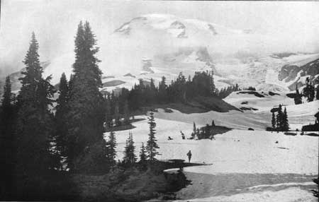
| Pl. LXXI. MOUNT RAINIER, FROM PARADISE PARK; LOOKING NORTH. Elevation of the foreground, about 6,500 feet; elevation of the summits, 14,000 to 14,526 feet. |
By the process outlined above a regular, smooth volcanic cone which reaches well above the snow line becomes sculptured by glaciers, so as to present a precipitous central mass, with a conical or dome-shaped summit, according to the shape of the original peak, bounded by the steep walls of amphitheaters and surrounded by secondary peaks and crags forming the apices of V-shaped residual masses between primary glaciers. From these tahomas—using the nane of the best example on the sides of Mount Rainier as a generic term—descending lines of crags forming rocky ribs lead down to the platform on which the mountain stands.
The extension of the amphitheaters at the heads of the primary glaciers renders the sides of the central dome more and more precipitous as glacial erosion progresses. Certain of the primary glaciers may advance with their task of excavating the slopes which they descend more rapidly than others and cut back their amphitheaters faster than do their neighbors, thus making the central dome unsymmetrical. This is the case in the present stage of the erosion of Mount Rainier. Carbon Glacier, flowing northward and having its amphitheater sheltered from the noonday sun, has excavated a great recess or cirque in the side of the mountain, while the glaciers on the south side of the peak have scarcely more than begun to form similar recesses.
The process outlined above, by which an isolated snow-covered cone is sculptured by glaciers and by the streams flowing from them, is not an ideal picture of what may occur, but is rather a statement of what has taken place on Mount Rainier. The regularity in the development of topographic forms that would result from the sculpturing of a conical mountain of homogeneous rock has been modified in the example before us by irregularities in the primitive form, due in part to the truncation of the summit, but to a much greater extent by variation in rock texture. Mount Rainier, as already stated, is a composite cone built of projectiles and lava streams. The portions formed of agglomerate are open in texture and yield readily to mechanical erosion. The lava flows are frequently dense and compact and stand in relief when the adjacent agglomerate is worn away. Inequalities in snowfall also occur, owing to the prevalence of westerly winds, and, as previously mentioned, snow melting is greatest on the southern, or possibly the southwestern, side of the mountain. At an early stage in the history of the mountain after it had ceased to be an active volcano the heat of the rocks must have influenced the rate at which the snow falling on it was melted. This influence was greatest and longest continued at the summit, as some effects of the residual heat of the rocks are still to be seen there. From this cause the summit may have been bare for a long time after glaciers originated on the sides of the mountain and had begun their task of eroding the rocks.
The varied conditions just enumerated, and possibly still others, would lead to modifications in the orderly sequence of topographic changes that a lofty isolated peak of homogeneous rock would pass through.
Changes in the topography of Mount Rainier have also been influenced by great variations in climatic conditions. The mountain is supposed to be of Tertiary age, probably Pliocene (as to the definite time at which it was built I can offer no direct proof), and was exposed to the climatic changes which were such a marked feature of the Glacial period. The extent of the glaciers that flowed away from the peak during the Glacial period and the variations they experienced have not been made out. Such facts as are in hand bearing on this question indicate that the primary glaciers were well established before the coming of the Glacial period and that the ice drainage during its maximum followed valleys previously outlined, which were greatly deepened.
In spite of the modifying conditions enumerated above, and possibly still others that may have influenced the manner in which Mount Rainier has been sculptured, the changes in topography that the mountain has undergone make a near approach to what should be expected from the erosion by ice on the upper portion and by water on the lower slopes of a symmetrical peak of homogeneous rock of the height of the example before us and under the climatic conditions to which it has been exposed.
COMING TOPOGRAPHIC CHANGES.
With the postulate that existing climatic conditions will remain practically unchanged for a great length of time—the tendency of the glaciers to recede, discussed later, being checked—it is not difficult to sketch in outline the main topographical changes that Mount Rainier will pass through during the ages to come.
The primary glaciers are cutting back the cliffs encircling the amphitheaters from which they flow, and in their middle courses are slowly sinking into the sides of the mountain. This entrenching of the glaciers, by affording greater shelter for the ice, tends toward their preservation. The greatest changes in topography now in progress about Mount Rainier are at the heads of the glaciers that have made a marked advance in excavating their amphitheaters.
As an amphitheater recedes farther and farther into the side of an isolated peak the region favorable for the accumulation of snow and the growth of a névé becomes less and less extensive. For this reason the enlargement of an amphitheater leads to a decrease in the size of the glacier flowing from it. This is illustrated at the present time on Mount Rainier by Carbon Glacier, which has formed a large amphitheater on the north side of the peak. The snow on the less steep slope above the cliff leading to Liberty Cap creeps down to the verge of the precipice and there breaks off and forms avalanches, which descend to the glacier below. Carbon Glacier in reality has no true névé at present, except the snow-covered area just mentioned, above the summit of the cliffs encircling its amphitheater. The gathering ground of the glacier has been decreased by the extension of the amphitheater until it is but a fifth or a tenth of its original extent. Some compensation for the decrease in the size of the névé, as a glacier enlarges its amphitheater, is found in the fact that as the enlargement takes place the divides between the amphitheater and adjacent névé fields crumble away, and the glacier whose amphitheater recedes most rapidly diverts some of the snow drainage that was previously contributed to the neighboring glacier. This process is illustrated by Carbon Glacier, which has enlarged the western side of its amphitheater so as to divert some of the névé which formerly supplied Willis Glacier.
Carbon Glacier is still enlarging its amphitheater, and, if the process does not check itself by decreasing the area on which snow for the supply of the glacier accumulates, will cause such a recession of the cliffs at its head that the central dome of the mountain will become broken. The present symmetrical form of the mountain's summit will then be modified and replaced by a crest having a steep descent to the north and a much gentler southern slope.
If other glaciers about Mount Rainier also cut back their amphitheater so as to break the summit curve of the mountain, pinnacles and crests will replace the present rounded dome. In this stage there would be a central core, or a matterhorn, as it may be termed, with precipitous ribs and angular summit, surrounded by deep amphitheaters. When this stage is reached the gathering ground for névé fields will probably be so reduced that the glacier will shrink and have but little influence on the succeeding topographic changes which the mountain will pass through.
After the glaciers have ceased their work, weathering and stream erosion will continue. The mountain will become more and more angular, owing to the sculpturing of deep radial valleys down its sides, and the peaks and crests left between them. The history in store for the mountain when it is so altered in shape and reduced in elevation—with the exception of the central core—that glaciers can no longer be supplied by its snow, is illustrated by many ancient volcanic piles and need not be discussed at this time. Briefly stated, the topographic diversity of the mountain will increase for a time, and gradually the central core of hardened lava, filling the pipe through which eruptions formerly reached the surface, will be brought out in relief by the removal of the less compact agglomerates and lava sheets about it and stand as a tower above the ruins surrounding it. This "volcanic neck" will slowly crumble and sink to the condition of a rounded hill with rock fragments on its summit. The ultimate fate of the once glorious mountain is reduction to baselevel. When this topographic phase is reached, a plain, but little elevated above the sea, will occupy the place where now stands Mount Rainier.
| <<< Previous | <<< Contents >>> | Next >>> |
rpt/18-2/sec1-6.htm
Last Updated: 28-Mar-2006