
|
Geological Survey Professional Paper 160
Geologic History of the Yosemite Valley |
POSTGLACIAL HISTORY OF THE YOSEMITE VALLEY
It remains to consider the changes that have been wrought in the aspect of the Yosemite Valley during postglacial time—that is, during the interval that has elapsed since the ice age. The magnitude of those changes is commonly underestimated—indeed, the belief seems to prevail that the Yosemite region presents to-day much the same appearance as it did immediately after the evacuation of the ice. Close observation, however, reveals the fact that some radical and many minor changes have taken place and that the Yosemite of to-day differs in some respects markedly from the Yosemite at the end of the glacial epoch.
The postglacial interval is variously estimated by geologists at 15,000 to 30,000 years. It has therefore been brief, in the geologic sense, yet it has lasted long enough to permit the processes of disintegration, erosion, and deposition to accomplish significant results in some places. It has permitted the valley walls to be dismantled in part and to be cloaked with rock waste at their bases, and it has permitted the lake basins excavated by the glaciers to be filled with stream-borne sediments. During the postglacial interval, therefore, the Yosemite region has lost much of its ice-given grandeur and grimness of aspect and has gained in habitableness and charm.
The most radical changes produced in its landscape were due to the filling and complete obliteration of the glacial lakes. It will be appropriate, therefore, to describe these changes first.
FILLING OF THE GLACIAL LAKES
FILLING OF LAKE YOSEMITE
To the camper who pitches his tent in one of the Yosemite's shady groves it may not occur, perhaps, that the spot he has selected for his temporary abode once lay in the midst of a mountain lake of exceptional beauty—a sheet of water in which the cliffs of El Capitan and Half Dome as well as the sprays of the Yosemite Falls were reflected. Yet there can be no doubt that the present embowered, parklike floor of the valley replaces such a body of water.
Ancient Lake Yosemite occupied the entire length and breadth of the main Yosemite chamber. (See fig. 16.) It was 5-1/2 miles long, extending from the moraine dam at the El Capitan Bridge to the great wall at the head of the valley, and its waters lapped the bases of the freshly glaciated walls on each side. As already explained (p. 94), the lake owed its existence not to the moraine dam alone; it occupied an elongated basin scooped out in the rock floor of the valley by the ancient Yosemite Glacier, and its depth was merely increased somewhat by the moraine dam, which was situated on a broad rock sill at the lower end of the basin.
The depth of the lake basin is not known, as no borings have ever been made, but cross profiles of the valley (figs. 24 and 25), plotted accurately from the contouring of the topographic map, give a fair basis for estimates. If the bottom curves in these cross profiles are drawn in accordance with the characteristics of the exposed rock floors of other Yosemite-like canyons in the High Sierra, they indicate a depth ranging from 100 to not less than 300 feet. The basin was deepest probably in the upper part of the valley, opposite Yosemite Village.
The filling of the lake no doubt began before the ice completely left the valley, but the main work was done by the Merced River and Tenaya Creek. When the Yosemite Glacier had departed each of these streams, by depositing the glacial débris which it carried at the point where it entered the lake, began to build a delta. These deltas grew forward rapidly and in time coalesced into one large delta when the streams joined each other. This large delta then grew forward down the valley until, probably in the course of thousands of years, its front reached the moraine dam, and the basin was completely filled.
The appearance of Lake Yosemite during its gradual extinction and the aspect of the delta at its head may be readily imagined by anyone who has visited Merced Lake (pl. 12, B) or Washburn Lake. Each of these lakes is now being encroached upon in precisely the same manner as Lake Yosemite was, by a slowly forward growing delta composed of stream-borne sand and gravel. Each lake, in fact, is already reduced to two thirds its original length and has at its head a delta plain half a mile long. These delta plains have gently sloping surfaces, cut only by the channel of the river and by a few old, abandoned channels. Each delta is fronted by a sandy beach that is beaten by the waves a sweeping concave curve on each side of the slightly projecting river mouth.
It is probable, further, that like the deltas at Merced Lake and Washburn Lake, the delta at the head of Lake Yosemite was largely covered with vegetation. Its more stable portions bore forest trees, and its shore was fringed with willows. That the climatic conditions permitted vegetation thus to establish itself upon the delta shortly after the retreat of the glaciers can scarcely be doubted, for there are indications in various parts of the Sierra Nevada that even during glacial time extensive forests of pine and sequoia flourished on its lower slope and well up on the ridges between the canyons.
As the delta plain was extended forward it was also built up gradually, for the streams, which were heavily loaded with débris, had to maintain a sufficient slope to transport it. The coarser material naturally they dropped soon after emerging into the valley, and as a consequence their gradients were steepest at the valley head. They had a fall there of about 20 feet to the mile, whereas throughout the greater part of the lake basin they had a fall of only 3 feet to the mile.
The present valley floor, as a matter of fact, does not represent the original delta plain that was formed in the manner just described but is a relatively new plain that lies at a level 14 to 16 feet lower. Probably as the result of a rather sudden breaching of the moraine dam the Merced River cut down its bed and trenched the plain until at length it established a new grade similar to the first. Then, winding sluggishly from side to side, it widened out a new plain at the expense of the old one. In only a few places are remnants of the old plain left in the form of terraces. A particularly prominent terrace of this sort overlooks Tenaya Creek near the head of the valley. The level plain in front of Camp Curry is another terrace. More extensive remnants of the old plain occur north of the Cathedral Spires and the Cathedral Rocks.
The present valley floor has the characteristic features of what is properly termed a flood plain; low natural levees along the river banks slope gently away from the stream and are breached in places by overflow channels, and in the plain beyond are numerous crescent-shaped sloughs outlining old oxbow bends abandoned by the river when it shifted its course. All these features show that the river has almost ceased to cut and at times of high water builds up the valley somewhat by depositing sediment. Every year, as a rule in the month of May, floodings occur as a result of the rapid melting of snow in the High Sierra. Fortunately the water spreads only over the lower ground and attains a depth of only a few feet. No material damage is done, as all permanent structures in the valley are built on relatively high ground.
FILLING OF LAKE IN THE LITTLE YOSEMITE VALLEY
But scant reference has been made thus far to the lake that once occupied the Little Yosemite Valley. It must have extended over the entire length and breadth of the floor, measuring about 2-1/2 miles in length and somewhat less than half a mile in average width. Like the body of water in the Yosemite Valley, it lay in a rock basin scooped out by the glaciers, but it was impounded only by a rock barrier and had no moraine dam in addition. The rock barrier at the lower end, now cleft by a narrow gorge through which the river passes in brawling rapids, is situated about half a mile above the Nevada Fall. The lake shallowed gradually toward its outlet and probably attained no great depth at any point. The deposit of river gravel that now fills the basin is not thick enough to cover the crests of the numerous small moraines which the Merced Glacier left as it retreated. As may be seen on Plate 29, some of these moraines cross the basin fully a mile above the outlet. They stood probably only about 30 feet in height, hence the depth of the lake in that vicinity must have been only about 25 feet. The maximum depth occurred probably half a mile farther up and may have exceeded 50 feet.
A basin so shallow naturally was not long in filing. The lake in the Little Yosemite, therefore, was obliterated perhaps even before Lake Yosemite was filled, although the Little Yosemite was evacuated by the ice much later than the main valley. The general process of filling, by the forward growth of a delta, no doubt was the same in each lake.
SIGNIFICANCE OF LOST LAKE
Lost Lake has probably always been a separate body of water, not communicating with the larger lake in the Little Yosemite. It lies on a rock bench raised somewhat above the river gravel in the Little Yosemite and is walled in on the south side by a ledge of granite and on the southeast side by a moraine. It owes its existence to the collection of seepage water and the run-off from the surrounding mountain sides.
Lost Lake is now being filed gradually with a deposit of peat resulting from the accumulation of vegetal material. It is little more than a watery swamp and will soon reach that stage where it can no longer be referred to as a lake.
SURVIVAL OF EMERALD POOL
It may seem anomalous that Emerald Pool, the smallest of all the glacial lakes in the Yosemite region, should still be unfilled and in precisely the same condition as at the end of the glacial epoch. The explanation is found in the very smallness of the basin, in the smoothness of its sides and bottom, which are composed of massive granite throughout, and in the great momentum with which the water of the Merced River rushes into the pool as a result of its descent in the Silver Apron. (See p. 19.) At times of flood all the water in the pool is set in motion, and the powerful current sweeps through it unchecked, carrying all sand and gravel with it.
FILLING OF LAKES IN TENAYA CANYON
Although the steps in the floor of Tenaya Canyon are not especially clean-cut, their configuration nevertheless indicates or at least suggests the former existence of a glacially scooped lake basin on each tread. There were apparently four such lake basins in the stretch extending from the mouth of the canyon to the great step from which the Tenaya Cascade descends. The upper three were little more than ponds that must have been quickly filled, but the lowermost, near the mouth of the canyon, measured over a mile in length and probably was not filled until a long time after the glacier had withdrawn from the canyon.
Mirror Lake (pl. 47, A) might readily be supposed to be a remnant of this ancient lake—in fact, it is generally assumed to be of glacial origin, like most lakes in the High Sierra—but a scrutinizing study of it reveals that it is of relatively recent making and has had no connection whatever with the ice age. It is impounded wholly by masses of rock débris that fell in avalanches from both walls of the canyon, principally from a place on the west wall, just back of the Washington Column. West of the outlet of the lake, it is true, there is a small quantity of morainal débris, readily distinguishable from the angular avalanche material by the water—rounded and glacier—polished cobbles and pebbles which it contains; but there is no dam composed of such glacial material across the canyon.
|
|
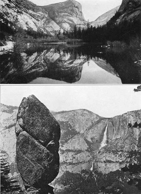
PLATE 47.—A (top), MIRROR LAKE. The basin
of Mirror Lake is not of glacial origin but was formed some time after
the ice by great rock avalanche thrown down presumbably by an
earthquake. The mountain reflected in the lake is Mount Watkins, the El
Capitan of Tenaya Canyon. Photograph by J. T. Boysen. B (bottom), AGASSIZ COLUMN. The prismatic form of the Agassiz Column is determined wholly by intersecting joint planes, vertical and oblique. The column is the last remnant of a rock mass that was divided by many such fractures. The cliffs about the Yosemite Falls, in the background, are comparatively massive. The rows of bushes accentuate the few horizontal and oblique master joints which determine the principal sculptural features. Photograph by A. C. Pillsbury. |
The creation of Mirror Lake by obstructing rock avalanches was of course favored by the fact that the lower part of Tenaya Canyon already had a nearly level floor due to the previous filing of a glacial lake basin. Had the floor not been so nearly level, the low, irregular avalanche dam would not have backed up the water for any great distance.
The postglacial history of lower Tenaya Canyon may be summed up as follows: (1) A glacially gouged lake basin about a mile in length was filled by the forward growth of a delta built by Tenaya Creek; (2) great rock avalanches fell from the walls near the canyon mouth and impounded the water anew, forming Mirror Lake; (3) Tenaya Creek built a new delta, which, growing forward, is now reducing the size of Mirror Lake.
The relative recency of its creation therefore explains why little Mirror Lake is still in existence, whereas the large lake basin in the Yosemite Valley is completely filled. Mirror Lake itself, however, appears to be not far removed from extinction. The rate at which the delta at its head is encroaching upon it from year to year is sufficiently rapid to be discernible to the eye without the aid of precise measurements. Indeed, unless steps are taken to check the further growth of the delta, Mirror Lake will soon be reduced to a small, unimpressive pond, and the Yosemite region will lose one of its most valued scenic treasures.
| <<< Previous | <<< Contents >>> | Next >>> |
pp/160/sec4.htm
Last Updated: 28-Nov-2006