
|
Geological Survey Circular 838
Guides to Some Volcanic Terrances in Washington, Idaho, Oregon, and Northern California |
ROADLOG FOR FIELD TRIP TO MEDICINE LAKE HIGHLAND
Julie M. Donnelly-Nolan, U.S. Geological Survey, MS 18, 345 Middlefield Rd.,
Menlo Park, CA 94025
Eugene V. Ciancanelli, Cascadia Exploration Corporation, 3358 Apostol Rd.,
Escondido, CA 92025
John C. Eichelberger, Geological Research G-6, Los Alamos Scientific Laboratory,
Los Alamos, NM 87545
Jon H. Fink, Geology Department, Stanford University,
Stanford, CA 94305
Grant Heiken, Geological Research G-6, Los Alamos Scientific Laboratory, Los Alamos,
NM 87545*
*Authors are listed alphabetically except first author. See Acknowledgements for further credits.
| MILES | (interval mileage in parentheses) | ||
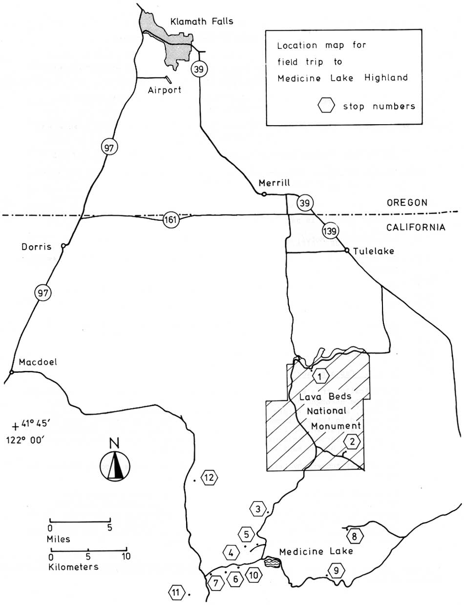
| 0 | Leave Cimarron Motel, 3060 So. 6th St., Klamath Falls, and head east | ||
| (3.1) | |||
| 3.1 | At "Y" in road, keep right to avoid going toward Winnemucca. Continue south on Oregon Highway 39. | ||
| (14.0) | |||
| 17.1 | Highway turns east at Merrill. Pass through town and continue east to | ||
| (2.0) | |||
| 19.1 | Malone Road. Turn right. Proceed south to State Line Rd. | ||
| (1.9) | |||
| 21.0 | Jog left to State Line Liquors, then right, and continue south toward Fish and Wildlife Headquarters. Continue south along fault scarp toward | ||
| (12.8) | |||
| 33.8 | Lava Beds National Monument. Turn left at "T." | ||
| (3.3) | |||
| 37.1 | STOP 1. Captain Jack's Stronghold. Geologically, this stop illustrates flow-end features in a high-alumina basalt flow. The stronghold is one of the major features at Lava Beds National Monument, and Aaron Waters has contributed his geo-historical study of the Stronghold to the published guidebook. One of the Park Rangers, Patti Easterla (whose grandfather was born in the Stronghold during the Modoc War) has agreed to guide us through this natural fortress and explain how so few Indians were able to hold off so many U.S. soldiers for so long. The unusual topography here, which was so critical to the Modoc's defense, is explained by Waters (this volume). Drive west from Captain Jack's Stronghold, facing directly toward the north-south fault scarp known as Gillem's Bluff. Pre-Highland lavas are exposed in the scarp, which is one of several stepping up to the west. As the road turns south, note the Big Horn Sheep Enclosure where some 35-40 sheep currently live. The Park Service is attempting to reintroduce the sheep which were once native but were killed off around 1900. As you leave the fault scarp and head southeast, cross the Devil's Homestead flow which is very young in appearance. It apparently vented at Fleener Chimneys, spatter cones sitting astride the southward continuation of the Gillem's Bluff fault scarp. | ||
| |||
| (12.9) | |||
| 50.00 | Visitor Center | ||
| (1.7) | |||
| 51.7 | Turn left onto Valentine Cave Road | ||
| (0.2) | |||
| 51.9 | STOP 2. Valentine Cave. This is one of nearly 300 lava tube caves in Lava Beds National Monument. Many of the more important and accessible caves have been mapped in detail by Aaron Waters and his field assistants, at the request of the National Park Service. Waters has also written descriptions to accompany the maps, one of which describes Valentine Cave (Waters, 1976). "Valentine is an interesting, clean and varied cave. Here one can see a lava-tube system which is almost undamaged by post-lava collapse. The cave shows most of the features to be found in lava tubes: among them pahoehoe floors, lava pools, and lava cascades; well-developed lavacicles and dripstone on ceilings and walls; extraordinarily interesting lava benches, one of which marks a high-level stand of viscous lava that attempted to crust outward from the walls; and still another kind of bench made by the penetration and "bulldozing" away of collapse blocks and rubble as molten lava under hydraulic pressure forced its way through the tube. Large pillars around which the lava stream divided and reunited are present in the upper part of the cave. The central part of the cave shows interesting lava falls and cascades through which the lava stream was transferred from a higher level to a lower level. Downstream from this area of breakdowns, the Valentine tube subdivides into distributaries which are gradually phased out downstream by filling with lava." | ||
| (0.3) | |||
| 52.2 | Return to main road and turn right. | ||
| (2.8) | |||
| 55.0 | Drive past Visitor Center again and turn left onto dirt road to Medicine Lake. | ||
| (4.6) | |||
| 57.6 | Mammoth Crater (optional stop). Pit crater at summit
of broad, low, basaltic shield. Source of many of the lavas in the
Monument, probably including the flow that made the Stronghold (Waters,
this volume.) Continue south, first on paved and then on dirt road. | ||
| (6.3) | |||
| 63.9 | Turn sharp right and drive one-tenth of a mile along west side of spatter cones. | ||
| (0.1) | |||
| 54.0 | Park and walk north along spatter cones, then up onto flow for STOP 3. Tree Molds There are numerous tree molds in the area immediately north of the last of the several spatter cones that are aligned approximately north-south. The lava was apparently very fluid when it first emerged, flowing around the trees in its path. Many of the molds are large enough to climb down into. Most are 10-15 feet deep; a few had snow at the bottom all summer. About 200 feet north of the last spatter cone, the flow has a rougher surface and there appear to be no more molds. | ||
| (0.1) | |||
| 64.1 | Return to main road and turn right; continue south. | ||
| (1.8) | |||
| 65.9 | Turn right on good dirt road. | ||
| (1.0) | |||
| 66.9 | STOP 4. Cracks. Park and hike northwest about 200 feet to narrow dirt track. Turn left and walk about half a mile into an area of recent cracks. The largest one is 30 to 40 feet deep and has snow at the bottom. The exposed sequence is pumice over scoria, both overlying platy andesite that is well-displayed in the ragged edges of the cracks. Most cracks trend north to northeast here, with the west side down where offset can be determined. This is the same offset displayed at the next part of Stop 4. Faulted cinder cone. Return to dirt road track and walk northwest to pumice-covered cinder cone. Climb up on cone and stand on east side of fault scarp. The scarp is red and bare of pumice, thus fault movement followed deposition of the pumice. The fault trends north-northeast and at each end is covered by a very young rhyolitic flow. There is an excellent view to the northwest from this spot. Eat lunch and then proceed north along the fault to Crater Glass Flow. Climb up on the flow and examine the spines on the surface. Note the scarcity of pumice on top of the flow despite the abuncance of pumice surrounding it. Return to cars and proceed northeast to junction with main road. | ||
| (0.8) | |||
| 67.7 | Park for STOP 5. Glacial Striations. Andesite is polished and grooved in a northwesterly direction. See Anderson (1941) for a description of the glaciation of the Highland. Return to cars and proceed northeast to junction with main road. | ||
| (0.2) | |||
| 67.9 | Turn right and drive south over rim of caldera as described by Anderson (1941). | ||
| (0.3) | |||
| 68.2 | View of Medicine Lake basin and the young Medicine Lake flow (dacite). Follow the road down and south past the dacite flow. | ||
| (2.1) | |||
| 70.3 | At the Ranger Station, turn right. Proceed along main road, keeping to the right at next intersection with a good road. | ||
| (2.4) | |||
| 72.7 | Turnoff to Little Mt. Hoffman. Keep right. | ||
| (1.4) | |||
| 74.1 | At Little Glass Mountain, turn left and follow east edge of flow. | ||
| (0.3) | |||
| 74.4 | STOP 6. Park for first Little Glass
Mountain stop. See accompaning article
by J. H. Fink for description. This stop offers an opportunity to observe the different units which make up the flow stratigraphy. First we note the layer of tephra which covers the ground surrounding the flow. Isopach maps indicate that the source of this tephra is under Little Glass Mountain (Heiken, 1978). | ||
| (0.3) | |||
| 74.7 | Return to junction and turn left, driving around north side of Little Glass Mountain. | ||
| (1.5) | |||
| 76.2 | STOP 7. Park for second Little Glass
Mountain stop. See accompaning article
by J. H. Fink for description. Turn around and return to Medicine Lake. | ||
| (7.2) | |||
| 83.4 | Medicine Campground. SECOND DAY Leave Medicine Campground. Proceed east to Arnica Sink turnoff. | ||
| 83.7 | Turn left. | ||
| (0.8) | |||
| 84.5 | View of Arnica Sink. Take either fork. Andersen (1941) felt that Arnica Sink had been connected with Medicine Lake prier to extrusion of the Medicine Lake dacite flow. Keep on the main road and head east. | ||
| (1.1) | |||
| 86.6 | Road junction. Turn left. Note Hoffman dacite flow on left. | ||
| (0.8) | |||
| 87.4 | Road junction. Turn left toward Glass Mountain. | ||
| (1.5) | |||
| 88.9 | Pause for view: dome of Glass Mountain to northeast, Hoffman flow (dacite) in foreground, rhyolite dome of Mt. Hoffman to northwest (highest point on the Highland, and directly north is a bare area on the forested ridge in the distance. At the bare area (the "Hot Spot") steam is emitted and temperatures of 89° C have been measured within a half meter of the surface. Continue around south edge of Glass Mountain. Red Shale Butte and Lyons Peak, on the right, consist mostly of basalt and andesite. | ||
| (4.2) | |||
| 93.1 | Road junction. Turn left. | ||
| (9.7) | |||
| 102.8 | Sharp left turn onto dirt road (sign points to Lava Beds N.M., 10 mi.). | ||
| (0.6) | |||
| 103.4 | Road junction. Keep left. | ||
| (0.8) | |||
| 104.2 | Turn left onto pumice-covered road. | ||
| (2.4) | |||
| 106.6 | Road junction. Keep right. | ||
| (0.4) | |||
| 107.0 | Turn sharp left onto narrow road running parallel to flow front. | ||
| (0.2) | |||
| 107.2 | STOP 8. Glass Mountain Park and walk up bulldozed road onto flow. This location was chosen specifically to show the mixing of magmas involved in the genesis of the Glass Mountain dacite-rhyolite flow (Anderson, 1933; Eichelberger, 1974, 1975). The north quarry site affords an opportunity to see the extremes in lava types produced during a single eruption of the Glass Mountain volcano. Thirteen vents along a northwest-southeast trending fissure were active during this eruption, which occurred within the last thousand years. Nine northwestern vents and the southeastern-most vent produced domes, while lavas of the intervening three vents coalesced to form the Glass Mountain flow, 1 km3 in volume. The flow consists of three dacitic eastern lobes which grade westward to rhyolite and are overlain by rhyolite lobes. We are now at the point where the largest of the rhyolite lobes stopped as it overran the largest of the earlier dacite lobes. The dacite lobe flowed a total of 6 km from the middle flow vent; our present location is 3-1/2 km from that vent. The northern flow vent probably also fed this lobe, and the southern flow vent may have contributed lava as well. The rhyolite lobe came entirely from the northern flow vent, 3 km distant. However, there was no break in the eruption between the two lobes, since the lobes merge in a continuous surface west of the vents. Nor is there any discontinuity in lithology, since the dacite lobe grades upstream to rhyolite at the middle and south vents. Variation in lithology within lobes occurs over a shorter distance normal to stream flow, reflecting the strong velocity gradient in that direction during emplacement. Hence "younger," and therefore more rhyolitic, lava occurs in the inner portion of each lobe. Contrast between the older and younger lobes is apparent in flow morphology as well as lithology. The rhyolite lobe is 2-3 times thicker than the dacite lobe on the same slope. The dacite varies from dense, massive lava with some flow banding to vesicular, scoriaceous, and brecciated materials, particularly abundant on the flow surface. The dacite always contains abundant basaltic xenoliths, and a large portion of the phenocrysts within the dacite were derived from disaggregation of these xenoliths. The rhyolite varies from dense obsidian to very light pumice which is confined to the surface. Obsidian has been forced upward through the surface pumice in pressure ridges. Interiors of both the dacite and rhyolite lobes are massive lava. Samples of the basaltic xenoliths have a density of 2.15±0.04 g/cm3 independent of the vesicularity or composition of the host lava. The mass density of the xenoliths (i.e. density without vesicles) is 2.79±0.01 g/cm3. Densities of non-vesicular host lavas are as follows: obsidian near middle vent—2.38±0.01 g/cm3, dacite at this stop—2.49 g/cm3, dacite at distal end of this lobe—2.55 g/cm3. Development of this compositionally zoned flow can be viewed as a consequence of "bubbling" of basaltic magma through a rhyolitic magma chamber. Bulk composition and phase assemblage of the dacite are attributable to addition of basaltic material to rhyolitic magma. The rounded shape of the xenoliths and distinctive "quench" texture indicate that basalt was introduced into the chamber as a liquid, was chilled against rhyolitic magma, and consequently underwent rapid crystallization. Vesiculation accompanying crystallization produced a layer of low-density foam at the base of the rhyolitic magma body. This foam was removed by flotation as it formed and became concentrated at the roof of the chamber. The volume increase due to inflation of the foam triggered the eruption which first tapped the foam-rich hybrid dacite at the top of the chamber. Eruptions of similar lavas prior to the Glass Mountain event suggest that the chamber is a large-volume, long-lived feature beneath the Highland. Known densities of the materials, evidence that flotation occurred, and reasonable estimates of water content of basaltic magma constrain the depth of this chamber to within about 10 km of the surface. The road onto the flow provides easy access to the surface of the rhyolite lobe. The climb takes 15-20 minutes and provides views of the summit dome which was extruded from the north flow vent, the distal end of the dacite lobe, and many other interesting features of Glass Mountain and its environs. | ||
| (1.4) | |||
| 108. | Drive east on narrow road back to main road. Turn right. | ||
| (3.9) | |||
| 112.5 | Junction with paved road. Turn sharp right and return toward Medicine Lake. | ||
| (9.8) | |||
| 122.3 | Turnoff to Glass Mountain. Keep left. | ||
| (0.9) | |||
| 123.2 | STOP 9 (optional). At second turnoff to Glass Mountain, park at intersection and hike north in to explosion crater. This is one in a northeast-trending series of explosion craters which extend for about three miles. These craters expose the local stratigraphy which here is andesite over porphyritic Lake Basalt. Continue on main gravelled road keeping first right, then left, at intersections with other good roads, to four-way intersection. | ||
| (3.4) | |||
| 126.6 | Turn right toward Medicine Lake. Continue past Medicine Lake campgrounds and Ranger Station west toward Little Glass Mountain. | ||
| (6.1) | |||
| 132.7 | Little Mt. Hoffman turnoff. Turn left. | ||
| (0.7) | |||
| 133.4 | STOP 10. Little Mt. Hoffman Lunch and panoramic view (weather permitting) of Mt. Shasta, Lassen Peak, and Mt. McLaughlin, with Little Glass Mountain directly below us. | ||
| (0.6) | |||
| 134.0 | Bottom of Little Mt. Hoffman. Turn left at junction. | ||
| (1.4) | |||
| 135.4 | At Little Glass Mountain, keep right. | ||
| (2.1) | |||
| 137.5 | Turn left at main (Harris Spring) road. | ||
| (1.1) | |||
| 138.6 | Road to Lost Spring and Tennant. Turn right. | ||
| (0.8) | |||
| 139.4 | At junction with road to Tennant, continue straight ahead toward Lost Spring. | ||
| (0.9) | |||
| 140.3 | STOP 11. Andesite Tuff This is nearly the southernmost mapped exposure of this ash-flow tuff. Here it is nonwelded to partially welded and you can see both the unoxidized buff-colored matrix having dark gray pumices, and the reddish to reddish-brown matrix color which is more typical of this widespread and distinctive unit. It extends at least 200 feet uphill to the west and is nonwelded to partially welded throughout. According to mapping by Hughes (1974), the tuff is exposed a mile and a half to the north at at elevation of 6400 feet, its highest known occurrence. It is also mapped by Weaver (1975) four miles to the southwest. Hart (1975) mapped large areas of it in the northeastern quarter of the Bray 15' quadrangle, just west of the Medicine Lake quadrangle. Hughes, Weaver, and Hart were students of S. A. Mertzman at Franklin and Marshall College, and some of their work is summarized in Mertzman (1977). The thickest apparent exposure of the tuff is right here, but its poorly-welded character suggests that the tuff may simply be coating the surface of the hillside to the west. To the north, the tuff is exposed on the south side of Mt. Dome, almost 20 miles from here. To the northeast, we have mapped it east of the Callahan flow at about 5800 feet in elevation. In the areas to the north and east, it is a very thin unit, always less than 20 feet thick and typically 2-5 feet thick. The source of the tuff is unknown but may be buried under younger lavas to the northwest of Medicine Lake. If the tuff's average thickness is taken to be 20 feet and its areal extent to be 250 square miles, its total erupted volume is one cubic mile. Although its volume is minor, it is very important as a stratigraphic marker. Drive a tenth of a mile further down the road, turn around, | ||
| (2.1) | |||
| 142.4 | and return to Harris Spring road. Turn left. Proceed north on good road past cattle guard. | ||
| (0.8) | |||
| 153.2 | Turn right on next good dirt road. | ||
| (0.9) | |||
| 154.1 | Follow road east then south just past junction.
Park. STOP 12. Andesite tuff and basal stratigraphy of Highland Porphyritic olivine basalt overlies glassy andesite and underlies andesite tuff. Walk up on top of tuff to get view south toward the Highland. Directly to the south near Dock Well, about 5 miles from here the tuff overlies these same two units as well as two other andesites and two silicic domes. Anderson (1941) thought that the domes had intruded into a two-hundred-foot thickness of andesite tuff, but detailed mapping shows that the tuff flowed around the domes, lapping up onto the eastern one. The tuff is actually very thin, and it appears unstratified because it has flowed down a steep slope and because most blocks are viewed from the top. Samples collected near Dock Well yield a normal magnetic polarity. Further to the east, but west of the Callahan flow, the tuff is exposed in patches as high as 5600 feet. It overlies an olivine andesite, two basalts, and an older rhyolite flow. East of the Callahan flow it overlies a glassy porphyritic dacite and an andesite, as well as an older sequence of aphyric rhyolite and dacite on top of porphyritic spherulitic rhyolite. The pre-tuff sequence in each case is complex, with all rock types from basalt through rhyolite represented. The post-tuff sequence consists mostly of silicic andesites piled up around Medicine Lake and young basalts on the flanks of the volcano. The youngest eruptions are bimodal, with basalts lower and rhyolites higher on the volcano. Turn around and return to paved road. Turn right. About 4-1/2 miles further north, there is a good paved road to the right. Keep left and proceed northwest into Red Rock Valley, then west and northwest to Macdoel and Highway 97. Turn right and go north through Dorris toward Klamath Falls. For those returning to the Klamath Falls airport, turn right at Joe Wright Road (sign points to Kingsley Field which is the Klamath Falls airport). | ||
Acknowledgements
Donnelly-Nolan was principally responsible for the road log, but Ciancanelli, Fink, and Heiken provided valuable assistance in choosing field trip stops. Eichelberger wrote the description of Glass Mountain (Stop 8), Ciancanelli measured the temperature at the Hot Spot. L. Hose provided valuable assistance with field trip logistics and also discovered and mapped the exposures of andesite tuff east of the Callahan flow.
We wish to thank P. Easterla of the staff at Lava Beds National Monument for guiding us through Captain Jack's Stronghold and A. C. Waters for contributing the unpublished description of Valentine Cave. We also thank the U.S. Forest Service and the U. S. Park Service for their cooperation and assistance.
References
Anderson, C. A., 1933, Volcanic history of Glass Mountain, northern California: American Journal of Science, vol. 26, p. 485-506.
_____ 1941, Volcanoes of the Medicine Lake Highland, California: University of California Publications, Bulletin of the Department of Geological Sciences, vol. 25, no. 7, p. 347-422.
Eichelberger, J. C., 1974, Magma contamination within the volcanic pile: origin of andesite and dacite: Geology, vol. 2, p. 29-33.
_____ 1975, Origin of andesite and dacite: evidence of mixing at Glass Mountain in California and at other circum-Pacific volcanoes: Geological Society of America Bulletin, vol. 86, p. 1381-1391.
Hart, W. K., 1975, Geology of the northern one-half of the Bray Quadrangle: map to accompany unpublished B.A. thesis, Franklin and Marshall College, scale 1:62,500.
Heiken, G., 1978, Plinian-type eruptions in the Medicine Lake Highland, California, and the nature of the underlying magma: Journal of Volcanology and Geothermal Research, vol. 4, p. 375-402.
Hughes, J., 1974, Geology of the western Medicine Lake Highlands and Garner Mt. Area, map to accompany unpublished B.A. thesis, Franklin and Marshall College, scale 1:62,500.
Mertzman, S. A., Jr., 1977, The petrology and geochemistry of the Medicine Lake Volcano, California: Contributions to Mineralogy and Petrology, v. 62, p. 221-247.
Waters, A. C., in press, Captain Jack's Stronghold: this volume.
_____ 1976, Valentine Cave: National Park Service unpublished document.
Weaver, S., 1975, Geology of the southeast Bray quadrangle, California: map to accompany unpublished B.A. thesis, Franklin and Marshall College, scale 1:62,500.
| <<< Previous | <<< Contents >>> | Next >>> |
circ/838/roadlog7.htm
Last Updated: 28-Mar-2006