
|
Geological Survey Bulletin 730—A
Peneplains of the Front Range and Rocky Mountain National Park, Colorado |
CYCLES OF EROSION IN THE ROCKY MOUNTAIN NATIONAL PARK.
FLATTOP PENEPLAIN.
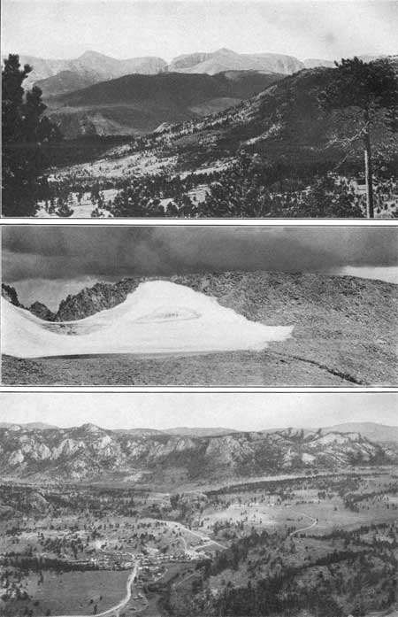
In the Rocky Mountain National Park near the crest of the highest range there are many flat or gently rounded surfaces that seem to be remnants of a peneplain. Most of them lie above timber line, which is here about 11,500 feet above the sea. One of the largest and most conspicuous of these remnants is on Flattop Mountain, whose name was suggested by its flat surface. (See Pl. II.) These remnants are so numerous and so close together that it is not difficult to reconstruct the old surface which they represent. Some of the gentler slopes are covered with residual soil, and the steeper ones with angular fragments of rock. A surface now connecting the several remnants would appear greatly warped and broken. Possibly the differences in altitude due to warping and faulting would in some places amount to a thousand feet or more. There are also peaks which were doubtless monadnocks on the old peneplain. Hallett Peak is plainly such a monadnock. (See Pl. II, A.) As viewed from the general level of the old peneplain this peak appears to be a dome rising about 500 feet, but from certain directions it appears to be a half dome, for the ancestor of Tyndall Glacier carried part of it away. Several smaller monadnocks are shown in Plate II, B. The nearly level top of Longs Peak may be a part of the Flattop peneplain warped up more than 2,000 feet, but it seems more likely that this mountain was a monadnock, although the nearly level surface of its summit, about 1,500 feet long and 1,000 feet wide, has been regarded as possibly a remnant of a peneplain still older than the Flattop peneplain. The rolling surface of the Flattop peneplain, which may be in part a product of recent warping, may be seen along the Continental Divide north of Longs Peak (Pl. III, A). Remnants of the same peneplain occur in many parts of the Rocky Mountain National Park on the highest mountains. Probably its most conspicuous remnant next to that on Flattop Mountain is on Hagues Peak (Pl. III, B).

|
|
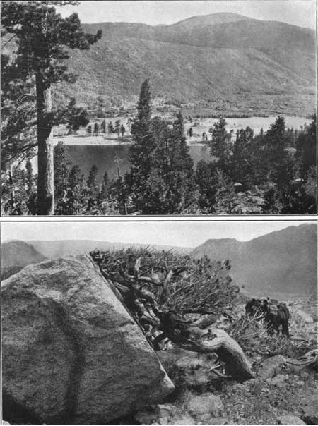
PLATE II.—A. FLATTOP MOUNTAIN COLO. A, Flattop Mountain, the type area of the Flattop peneplain. The gently inclined surface is at an altitude of about 12,500 feet. In the distance to the left is the flat summit of Longs Peak; in the middle ground is the rounded summit of Hallett Peak, a monadnock rising from the old peneplain; and in the distance to the right are tilted remnants of the same plain. Photograph by F. W. Byerly. B. GENERAL VIEW NORTHWESTWARD FROM FLATTOP MOUNTAIN. B, General view from Flattop Mountain (altitude 12,500 feet) northwest and across the peneplain to the Medicine Bow Mountains, in the distance at the left, the peaks of which rise to about the level of Flattop. |
|
|
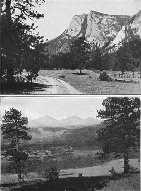
PLATE III.—A. THE CONTINENTAL DIVIDE, COLO. A, View of the Continental Divide from Deer Mountain, showing the Flattop peneplain and two monadnocks, Hallett Peak and Taylor Peak, on the sky line. A remnant of the Rocky Mountain peneplain in the middle ground, the glacial gorge of Thompson River, and the west end of the lateral moraine lying south of Moraine Park. B. HALLETT GLACIER, COLO. B, Hallett Glacier and a part of the Flattop peneplain at an altitude of 13,400 feet, north of Hagues Peak. In the dark parts of the glacier old crevassed ice is exposed. C. ESTES PARK, COLO. C, View from Prospect Mountain northwestward across Estes Park to The Needles, showing the Rocky Mountain peneplain and a remnant of the higher or Flattop peneplain on the distant sky line. The park was eroded about 2,500 feet below the Rocky Mountain peneplain and shaped probably by the ice of the older or pre-Wisconsin stage of glaciation. |
In describing these highland surfaces as remnants of a peneplain I am not unmindful of the possibility that such surfaces may be formed in other ways,6 but here the large number of the remnants at about the same altitude and their wide distribution favor the belief in their formation by peneplanation.
6Davis, W. M., Leveling without base-leveling: Science, vol. 21, pp. 825-828, 1905.
ROCKY MOUNTAIN PENEPLAIN.
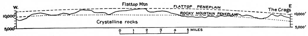
On both sides of the high mountains the peaks rise to a fairly uniform altitude of about 10,000 feet. As viewed from a sufficient distance (see Pl. III) to obtain broad relations these peaks appear to stand at a general level 1,500 to 2,000 feet lower than the Flattop peneplain (see fig. 2), which seems to have resulted from a definite though uncompleted cycle of erosion. But the peneplain thus produced is not now rendered conspicuous by flat surfaces such as mark the higher peneplain, because of the intensive subaerial and subglacial erosion of a later cycle. Remnants of the older plain are preserved in spite of the long erosion that followed its uplift, because they lie near the heads of the streams and are affected but little by stream erosion.
|
| FIGURE 2.—Profile across the Front Range through Flattop Mountain from Colorado River (at the extreme left; formerly called Grand River) to The Crags, Colo., showing the relation of the Flattop peneplain to the Rocky Mountain peneplain. (click on image for an enlargement in a new window) |
This general level to which the mountains of intermediate height in the national park rise is here correlated with the Rocky Mountain peneplain, because it corresponds in position and apparently in age to the surface of the top of Mount Lookout.
CANYON CYCLE.
During the cycle of erosion not yet finished the Rocky Mountain peneplain has been deeply incised and throughout wide areas has been completely destroyed. This latest or canyon cycle is a composite one and will doubtless be subdivided when more detailed work is done, but for the present the preglacial canyon cutting and the ice action are grouped together under the name canyon cycle.
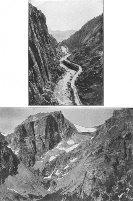
In the early part of this latest cycle the streams cut deep canyons, such as that of Thompson River (Pl. IV, A), through which the national park may be reached. Later in the cycle the heads of many of these canyons were glaciated and changed in form from the V-shape characteristic of stream work to the U-shape characteristic of glacial erosion. (See Pl. IV, B.)
|
|
PLATE IV.—A. THOMPSON CANYON, COLO. A, A V-shaped valley of the canyon cycle of erosion in the lower end of Thompson Canyon, cut in the upturned quartzite; looking downstream toward the Great Plains. In the distance is the "Red Beds" hogback of the foothills east of the mountains. B. GORGE BELOW TYNDALL GLACIER, COLO. B, A V-shaped valley or glacial gorge cut in granite and schist by ice during the canyon cycle of erosion. Tyndall Glacier, at the head of the gorge, extends up to the Flattop peneplain at an altitude of 12,300 feet. The lake in the foreground is at an altitude of 10,200 feet and is 1-1/4 miles from the head of the glacier. The cliffs rise about 2,000 feet above the lake. |
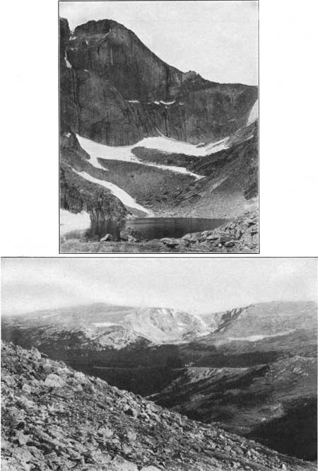
At least two stages of glaciation are represented here—a later one, presumably corresponding in time to the Wisconsin stage, and an earlier one, corresponding in time to one of the older recognized, stages. The results of the latest glaciation are conspicuously exhibited in the national park. Deep gorges (Pl. IV, B) and cirques were scooped out of the mountain sides by the ice, and morainal matter was heaped up to a depth of 1,000 feet or more. Many if not all of the gorges and cirques are stream-cut valleys that have been modified in form by the ice, but the excavation in some of them, such as The Chasm, on Longs Peak (Pl. V, B), was chiefly the work of a glacier, a fact shown by a comparison of the size of the cirque with the volume of morainal matter which obviously came from it. The ice at the Wisconsin stage modified the topography of both the Flattop peneplain and the Rocky Mountain peneplain. The gorge below Tyndall Glacier (Pl. IV, B) is cut into the higher plain, as is also the remarkably fine cirque near Comanche Peak (Pl. VI, B). The Rocky Mountain peneplain was affected to a less extent by the ice, for at the time it existed the glaciers on the eastern slope of the mountains occupied only the bottom parts of the valleys (Pl. III, A). Some of the moraines, such as the Mills moraine, were formed in part above the level of the Rocky Mountain peneplain (Pl. V, B), but most of them were built at lower levels (Pls. III, A, and VII, B).

|
|
PLATE V.—A. ANDREWS GLACIER, COLO. A, A view of Andrews Glacier from the lake in which the ice at its foot melts. Because of the great bend in the center the upper half of the glacier is not seen from the lake. B. MILLS MORAINE, COLO. B, Mills moraine, as seen from Twin Sisters. The glacier originated in The Chasm (Pl. VI, A), on the east slope of Longs Peak, and was about 4 miles long. The rock debris carried out of The Chasm was dropped chiefly at the sides, building up the ridges shown in the photograph. The moraines range in altitude from 9,500 feet at their base to nearly 12,000 feet. |
|
|
PLATE VI.—A. THE CHASM, LONGS PEAK, COLO. CIRQUES FORMED DURING THE WISCONSIN STAGE OF GLACIATION. A, The Chasm, in the eastern face of Longs Peak, as seen from Chasm Lake. The precipitous face of the cirque rises about 2,400 feet above the lake. B. CIRQUE NEAR COMANCHE PEAK, COLO. B, The cirque on the northern boundary of the Rocky Mountain National Park, 1 mile southwest of Comanche Peak, as seen from the saddle north of Hagues Peak, a distance of 5 miles. The cirque is 1 mile long, half a mile wide, and 1,000 feet deep. On both sides of the cirque is the Flattop peneplain, which has a maximum altitude here of more than 12,500 feet. |
|
|
PLATE VII.—A. MORAINE SOUTH OF COPELAND LAKE,
COLO. A, View from Copeland moraine above Copeland Lake, across the St. Vrain to the lateral moraine south of the valley. The glacier which built these great moraines originated in Wild Basin south of Longs Peak and moved down the valley 10 miles or more. B. TIMBER-LINE TREE ON LONGS PEAK, COLO. B, A timber-line tree (limber pine) on Longs Peak. A result of the prevailing westerly wind, which sweeps the snow from the highland plains into the cirques of the eastern slopes. The intense dissection of the mountains east of Continental Divide near Longs Peak (see topographic map of Longs Peak quadrangle) is due largely to glaciers formed of snow swept by the west wind from the Flattop peneplain. |
Some of the cirques and gorges still contain large bodies of snow and ice. It is uncertain how many of these bodies should be called glaciers. The mass of ice on Hagues Peak (Pl. III, B) has been named Hallett Glacier, after Mr. W. L. Hallett, of Colorado Springs, who visited it in 1884 and, noted the crevasses in the ice. For many years it was generally supposed that the Hallett was the only true glacier, in the Longs Peak region, but now four other bodies of ice in this group of mountains are recognized as glaciers and named on the topographic map of the Longs Peak quadrangle—Sprague Glacier, an arm of which is shown in Plate II, A; Tyndall Glacier, shown in the distance in Plate IV, B; Andrews Glacier, the body of ice shown in Plate V, A; and Taylor Glacier.
The former presence in the Longs Peak region of glaciers older than those of the Wisconsin stage has not been demonstrated, but such features as U-shaped valleys, perched lakes, and peat-filled basins beyond the known limits of the Wisconsin ice go far toward such a demonstration. In the Black Canyon (Pl. VIII, A) the broad floor of the valley and the steep cliffs that rise precipitously 2,000 feet at its side suggest oversteepening of the walls by ice. In the character of the rock of the walls, which is massive granite, and in the form of the valley there is so striking a resemblance to Yosemite Valley as to suggest similar origin, yet Black Canyon did not contain a glacier during the Wisconsin stage. It is tributary to Estes Park (Pl. III, C), which presumably was filled with ice during this older stage of glaciation. Tahosa Valley (Pl. VIII, B) also may have been shaped, at least in part, by the older glaciers.
|
|
PLATE VIII.—A. BLACK CANYON AND THE NEEDLES, COLO. RESULTS OP PRE-WISCONSIN GLACIATION. A, Black Canyon and The Needles. This canyon was not occupied by ice during the last stage of glaciation, but the broad, gently sloping floor and precipitous wall of granite rising 2,000 feet to the Rocky Mountain peneplain, which appears on the right, is suggestive of intensive ice action such as shaped the Yosemite Valley. B. LONGS PEAK AND TAHOSA VALLEY, COLO. B, Longs Peak and Tahosa Valley. This valley is outside the area of Wisconsin glaciation, but its broad, smooth floor at an altitude of 9,000 feet, a mile or more in width, with mountains east of it rising to an altitude of 11,436 feet within a mile and mountains west of it rising to an altitude of 14,255 feet within 4 miles, suggests glacial action. |
| <<< Previous | <<< Contents >>> | Next >>> |
bul/730-A/sec2.htm
Last Updated: 8-Jan-2007