
|
Geological Survey Bulletin 707
Guidebook of the Western United States: Part E. The Denver & Rio Grande Western Route |
MAIN LINE OF RAILROAD FROM GRAND JUNCTION TO SALT LAKE CITY.
(continued)
|
|
SHEET No. 9 (click on image for an enlargement in a new window) |
|
Mounds. Elevation 5,442 feet. Denver 603 miles. |
On the right may be seen the branch line of the Denver & Rio Grande Western that leads to Sunnyside, one of the largest coal mines in the district and the only one that produces a merchantable quality of coke.68 Plate LXXXVI, B, shows the coke ovens at Sunnyside. The two lines run nearly parallel for some distance but finally unite at the station of Mounds. (See sheet 9, p. 232.) To the casual traveler the country over which he has been riding, as well as that which he can see about Mounds, probably appears to be barren and valueless, but should he pass this way in sheep-shearing time and have a few hours to examine the shearing plant which stands just north of the station, he might change his mind, for this is the center of a large sheep industry. It is said that 100,000 sheep were sheared at this plant during the season of 1916 and that many sheep were turned away.
68The following description of the mines at Sunnyside is given by Frank R. Clark, who has made a careful geologic survey of the region:
Coal has been mined at Sunnyside since about 1900. The town, mine tipple, and coke ovens are in the mouth of Whitmore Canyon at the end of the Sunnyside branch, about 18 miles east of Mounds. Two beds of bituminous coking coal, separated by 5 to 25 feet of sandstone and shale, are mined here. The lower and thicker coal bed ranges in thickness from 5 to 14 feet and the upper bed from 3 to 6 feet.
Mine development has been rapid and continuous since the beginning, and now the workings cover several square miles. An electric plant furnishes power for hoists and hauling motors, and light for town and mines. Power is also carried by a high-voltage line eastward over the mountain into Range Creek, a distance of 5 miles, where it drives pumps which deliver all the water used at Sunnyside for domestic purposes and for steam boilers. The daily output of the mines is about 2,500 tons of coal, most of which is converted into coke in beehive ovens. The coke and coal are hauled by "locals" from the mines to Helper, where through freight trains are made up. Most of the coke from Sunnyside is shipped to the smelter at Anaconda, Mont.
The coal at Sunnyside and throughout the Book Cliffs has been generally burned at the outcrop, producing a reddish color in the associated rocks. The burning has advanced inward along the coal bed at many points for more than 1,000 feet and beneath 1,000 feet of overlying material. The mine workings at Sunnyside have in several places surrounded the burned-out areas, thus showing the extent of the burning. The fire has penetrated the coal farther on the points of ridges between drainage channels than it did where the coal outcrop crosses the stream courses.
|
|
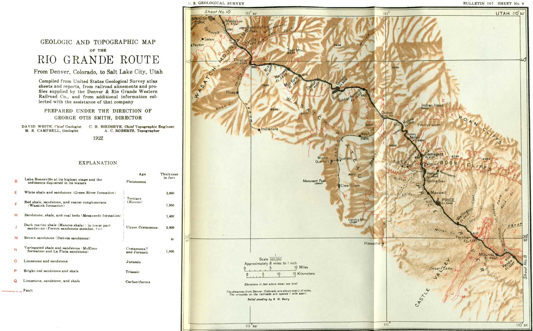
PLATE LXXXVI. A (top). BAND OF SHEEP.
One of the important industries in this part of Utah is sheep raising.
The bands of sheep, each band under the guidance of a herder or two,
range from the low grounds of the desert in the winter and early spring
to the highest ridges and plateaus in midsummer. Photograph by Frank R.
Clark. B (middle). COKE OVENS AT SUNNYSIDE. The Sunnyside mine of the Utah Fuel Co. is not on the main line of the railroad. but it is served by a branch which connects at Mounds. The coal mined at Sunnyside is the only coal in the State that will make commercial coke. Photograph by Frank R. Clark. C (bottom). CLIFFS ABOVE HELPER. The cliffs of sandstone underlain by shale are striking features as the traveler looks up at then from Helper, but when seen from the top they are equally interesting, for one can follow, with the eye, the various beds and note the form of sculpture of each particular layer. Photograph by Frank R. Clarke. |
It must be remembered, however, that the sheep sheared here do not depend upon this immediate vicinity for their pasture, for the sheep herder wanders with his flock during the summer into the high country of the San Rafael Swell (see Pl. LXXXVI, A) and in the winter seeks the protection of the lower valleys. The sheep would soon starve on a small area, but there is much open range—that is, unfenced Government land—in this country and by constant migration the sheep do well.
From the vicinity of Mounds the traveler may see that the Book Cliffs, which he has been following, continue northward only a few miles beyond the mine at Sunnyside, which generally can be located by its smoke, and there swing to the northwest to the head of Price River, near Helper, and there again change their course to a direction a little west of south—that is, they encircle the north end of the San Rafael Swell. The name Book Cliffs, however, is applied only to the part that lies east and north of the Denver & Rio Grande Western Railroad; the part that lies south of the railroad is known as the edge of the Wasatch Plateau. All these features can readily be seen from the train in the vicinity of Mounds.
Just west of Mounds curious hard masses of rock which on account of their nearly spherical shape are frequently referred to as "cannon balls" may be seen in the shale that forms the cut edge of one of the terraces. These round masses of rock are known to geologists as concretions,69 and they were undoubtedly formed in the shale after it was deposited as mud in the bottom of the ocean.
69The origin of concretions is not well understood, but they are supposed to be due to the collecting together in the mud of certain mineral particles, in much the same manner as the molecules of a mineral unite to form a crystal. Concretions, however, are generally rounded, or at least they are without sharp corners or straight sides, though they may take on a variety of forms, some of which are very complex and fantastic.
|
Farnham. Elevation 5,313 feet. Denver 609 miles. Wellington. Elevation 5,415 feet. Population 534. Denver 614 miles. Price. Elevation 5,546 feet. Population 2,364. Denver 619 miles. |
From the uplands at Mounds the road descends westward to Price River, which it reaches at milepost 607. Here the traveler is once more gladdened by the sight of green trees and small irrigated farms in the river bottom. The valley becomes rather narrow, and at Farnham the bluffs of shale encroach closely upon the river bottom. The shale hills are gray and barren, but they form a background that serves to heighten the color of the fields and trees.
From Farnham the railroad follows Price River practically to its head. Irrigation is generally practiced in the valley, but the supply of water is not sufficient to serve all the land that is otherwise favorably situated. Towns have sprung up along the railroad and are achieving more or less success. The next town to be passed is Wellington, which appears to be a thriving village, whose most prominent building is a modern schoolhouse.
Northwest of Wellington the valley is more open, and well-irrigated farms are abundant. The country on both sides of the river is served by canals that take their water from the river several miles above Price. Price is the county seat of Carbon County, which was so named because of the great beds of coal that are found in the Book Cliffs. It is a general supply point for the ranches in Duchesne Valley, north of the Book Cliffs, and in Castle Valley, south of them.
For a distance of 4 miles above Price the course of the river is southeastward and its bottom lands are fairly wide. The railroad is in this bottom and affords good views on both sides of the best part of the irrigated district. From this open valley the traveler may see. the shale terraces extending toward the river from both sides, like long fingers, and at point milepost 623 they approach so closely that the river flows in a veritable shale canyon, with steep walls on either hand that rise to a height of nearly 100 feet.
|
Helper. Elevation 5,840 feet. Population 1,606. Denver 627 miles. |
At this point the river also changes its course, coming out of the Book Cliffs in a course nearly due south. The valley continues narrow, with shale bluffs and a narrow strip of irrigated bottom land. Just beyond milepost 625 a branch line on the east (right) leads to Kenilworth, a mining town that produces a notable part of the coal shipped from this region. About a mile farther north, in a valley so narrow as scarcely to provide room for a single street, is the railroad town of Helper, which was so named because here are kept the light engines that serve the regular trains as "helpers" up the heavy grade north of the town. The town is at the mouth of the canyon that Price River has cut in the plateau of which the Book Cliffs are the front. These cliffs loom up 1,500 feet above the station and seem to interpose a blank wall against the further progress of the railroad, but like many other things in this world their appearance is deceptive, for the railroad has succeeded in following the stream through the narrow cleft. A view of the cliffs from above is shown in Plate LXXXVI, C.
The canyon above Helper shows at close range the character of the coal-bearing (Mesaverde) formation. The lower part of the cliff overlooking Helper is composed mainly of shale (Mancos), which originated in the sea and therefore contains no coal. The rocks above this shale are mainly sandstones, but there are also many beds of shale, and in places there are coal beds, which range in thickness from a few inches to as much as 20 feet. An old prospect in one of the thick beds is shown in Plate LXXX, B (p. 195). The coal beds, however thick they may be, can not generally be seen from the car windows, for they are the softest members of the formation and consequently weather back faster than either the shale or the sandstone, so that their outcrop becomes covered with soil and broken rock. Sandstone makes up the greater part of the formation, and its general color is light gray or nearly white. It has been described as red, but this is a mistake, as the formation contains no red sandstone, though a ledge on weathering becomes a rusty brown, or if point a coal bed below it has been burned it may have become a bright red, but these are not the inherent colors of the sandstone.70
70The following description of the coal beds and the associated rocks in the vicinity of Castlegate is given by Frank R. Clark:
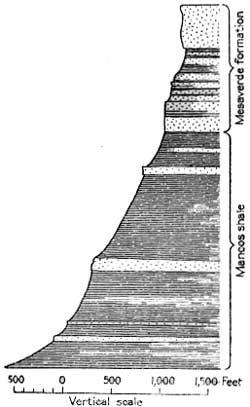
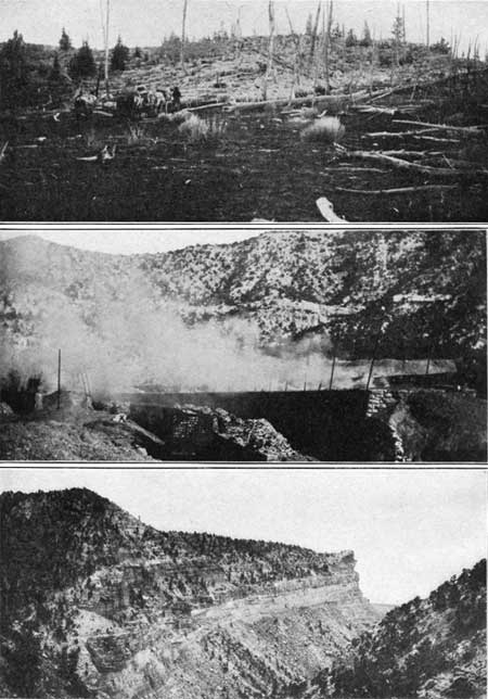
FIGURE 57.—Geologic section at Castlegate. At the mouth of Price River canyon nearly vertical cliffs of sandstone and shale rise 1,500 feet above the river bed. These cliffs are capped by beds of sandstone that form the lower part of the Mesaverde formation. The beds that compose the cliffs were laid down in fresh water or on the land. They rest upon soft dark shale (Mancos), which was laid down in a shallow sea that covered most of the country. The line between these formations is generally drawn at the base of the heavy ledge-making sandstone or at the top of the main mass of marine shale. The upper part of the Mancos shale in Price River canyon contains several prominent beds of sandstone (see fig. 57), which wedge out toward the east. The lowest of these beds crosses Price River about 3 miles below (south of) Helper, and the upper one crosses the river about midway between the town of Panther and the tipple of the Panther Coal Co.
The Mesaverde contains several coal beds which differ in thickness from place to place but where thickest are of great value. Coal is mined on a large scale along Price River canyon and its tributaries at Kenilworth, 2-1/2 miles east of Helper; Panther, half a mile south of Castlegate; Castlegate; Cameron, 1-1/2 miles northwest of Castlegate; Storrs, 3-1/2 miles northwest of Helper; Standardville, 4-1/2 miles northwest of Helper; and Hiawatha, 13 miles southwest of Price. The coal at Castlegate was formerly coked, but as the Sunnyside coal proved to be better adapted to coking, the Castlegate coking plant was abandoned. Three coal beds are mined at Kenilworth. The upper and lower ones are 18 to 20 feet thick, and the middle one is 4 to 6 feet thick.
The Castlegate group includes four coal beds, which differ greatly in thickness from place to place but are locally minable. At Cameron the coal does not come to the surface but is reached by a slope. The two beds that are mined are probably part of the Castlegate group. On the north side of the river, at Cameron, a massive sandstone crops out in a vertical cliff about 450 feet high. This sandstone is locally known as the Castlegate "reef" and crops out for many miles from east to west. (See Pls. LXXXVII, C, and LXXXVIII.) The sandstone gradually becomes thinner toward the east and at Sunnyside is only about 150 feet thick.
PLATE LXXXVII. A (top, left). INCLINED NORMAL FAULT. Displacement, 8 or 10 feet. As the surface is not offset by the fault the movement must have taken place long before the present valley was cut. Photograph by D. E. Winchester.
B (top, right). VERTICAL NORMAL FAULT. Displacement, 60 or 80 feet. Photograph by M. A. Pishel.
C (bottom). CASTLEGATE. SIDE VIEW. The sandstone pillar on the east (right) aide of the canyon. From this point of view it appears like a slender tower of the native rock almost ready to fall from the vibration of the passing trains, but when looked at from the north after having passed through the "gate" the picture is different, as shown in Plate LXXXX III. Photograph by Shiplers, salt Lake City.The section shown in figure 57 includes the rocks exposed from point the diversion dam on Price River 3 miles south of Helper to the Castlegate "reef" sandstone at Cameron.
Half a mile above Helper a branch railroad turns back to the left up Spring Canyon to coal mines at Storrs, Standardville, and other towns where mines have recently been opened, and about 2 miles above Helper the Utah Railway, a new line built to replace the one from Price to Hiawatha, connects the mines at Hiawatha, Mohrland, and Wattis with the Denver & Rio Grande Western.
The scenery in Spring Canyon, as in many others on the road, is dominated by great sandstones. This dominance is shown particularly by the narrowness of the canyon. Where the base of the cliffs is composed of shale the canyon is wider, as can be seen in the first 2 miles above Helper, but where the canyon walls are composed largely of sandstone, as they are farther up, the canyon is narrow, barely affording room for the automobile highway, the railroad, and the river. The walls of the canyon also show the effect of the different rocks; where they are mainly shale they have a pronounced slope, but where they are mainly sandstone they are precipitous and in places vertical. Each spur that projects into the canyon is preserved by heavy sandstone, and therefore the characteristic feature of the canyon is the many sandstone points which stand up like walls or dikes.
As the coal beds occur well up in the Mesaverde formation, they lie near the tops of the ridges at the mouth of the canyon, and the coal mines here must lower the coal by long inclined tramways to the tipple,71 which is at railroad level. This form of handling the coal is well illustrated at the Panther mine, near milepost 629. Farther up the canyon the coal beds lie nearer the creek level, and they finally pass below water level and are seen no more.
71The term "tipple" is applied in the soft-coal regions of the United States to the platform or building to which the coal is delivered from the mine. The tipple generally stands well above the railroad so that when the coal is dumped from the mine cars it descends by gravity through screens and is thus sorted into different sizes or grades before it reaches the railroad car in which it is shipped to market.
|
Castlegate. Elevation 6,120 feet. Population 1,120. Denver 650 miles. |
The most prominent mine and mining town on the main line is Castlegate, at the mouth of Willow Creek, which enters the main stream from the east (right). The mines are on both sides of the valley a few rods above the mouth of Willow Creek, and the coal taken from them comes to a common tipple, which spans the railroad at this place.
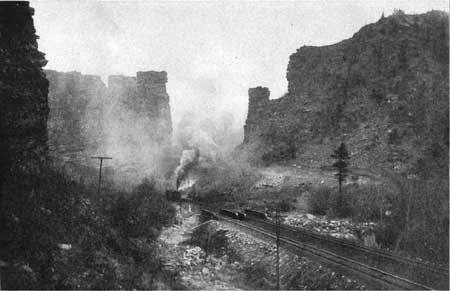
The name "Castlegate" was taken from that of the peculiar gate-like passage 2 miles above the town, the sides of which seem to be walls or dikes of sandstone projecting from the sides of the canyon. When viewed from a point directly opposite it the rock wall on the right looks like a thin finger, as shown in Plate LXXXVII, C, but when seen from a point farther up the canyon the walls on the two sides seem to project so far into the canyon as almost to obstruct it and to bar the railroad from further progress. This aspect of the gateway is shown in Plate LXXXVIII. As a matter of fact the two walls are not directly opposite, though this fact is not indicated in the illustration, but are offset a considerable distance, so that the opening is not so narrow as it appears. It is, however, a striking feature of the canyon and well deserves the name "Castlegate." The spurs that form the gate are not the only projecting ledges of sandstone, for each point or spur, whether it is at railroad level or high on the mountain side, is bounded by great cliffs of gray sandstone hundreds of feet high.
|
| PLATE LXXXVIII. CASTLEGATE. Projecting points of gray sandstone close in on the valley, leaving only a narrow passage resembling a gateway in the walls of some old ruined castle. The grade for the west-bound trains is heavy, and the canyon is generally filled with smoke. Photograph furnished by the Denver & Rio Grande Western Railroad. |
Throughout the main part of the canyon the railroad climbs steadily in order to cross over the top of the Wasatch Plateau. For about 10 miles out of Helper the grade is 127 feet to the mile, and though such a grade is not excessive it necessitates the use of extra engines on some of the heavy trains to get them to the summit.
Northward the canyon gradually grows less and less rugged and the walls decrease in height until just above the first tunnel, 1-1/4 miles above Nolan, the thick ledges of sandstone give place to weaker beds of muddy sandstone, shale, and fresh-water limestone. Although these point beds are in general gray, they belong to a different geologic formation from that which carries the coal beds at Castlegate. This formation, the Wasatch,72 which appears just above the first tunnel, is generally red, and in many places it is very coarse, but here it is light in color and is composed of fine material. Where the less resistant rocks form the surface the slopes become smoother and less steep and the general aspect of the canyon is much subdued. These gray beds continue to a point about half a mile above the station of Kyune.
72Wasatch formation was one of the first to be laid down in the Tertiary period. At the beginning of this period there was a wide uplift of many mountain ranges, and as soon as these ranges attained considerable height above sea level they were vigorously attacked by streams, which rolled great boulders down the steep slopes and deposited them at the foot. The finer material was carried away from the mountains by the streams, as similar material is to-day carried far away from the place where it originated, and was distributed over the fairly even surface. As water tends to drop coarse material first, the boulders, gravel, and sand were dropped near the mountains, but the clay was carried farther off, and finally all the earthy material found a resting place on the surface of the land or at the bottom of a lake. Such a lake probably existed in the Castlegate region, and in it were deposited the fresh-water limestones and shales which in this region constitute 700 or 800 feet of the lower part of the formation.
From the very manner of its origin and mode of transportation the Wasatch formation varies greatly in its composition, which depends upon the source of its material and the distance to which it has been carried. Such differences will be seen by the traveler long before he reaches the end of his journey. One feature of the Wasatch, however, is remarkably constant—its red or maroon color, which is characteristic of the formation generally throughout the Rocky Mountain region and is the most reliable means by which it can be identified.
|
Kyune. Elevation 7,013 feet. Denver 639 miles. Colton. Elevation 7,170 feet. Population 49.* Denver 645 miles. |
The upper part of the Wasatch is composed mostly of red clay or shale and appears to contain only a few beds of sandstone. Some of these beds have been quarried extensively above Kyune, where this part of the formation first makes its appearance. As the upper part of the Wasatch formation in this locality is composed largely of soft material, the slopes are gentle and the immediate hills are low. Here and there a harder or a thicker bed appears at the surface, and at these places the valley becomes more like a canyon. The railroad follows the boundary between the gray and the red parts of the Wasatch formations for some distance above Kyune, cutting in places into the gray beds and in places into the red ones. A short distance west of milepost 643 the railroad leaves the red beds and for a mile it traverses the light-colored limestones and shales. In these rocks the stream has cut a canyon, which bears off to the southwest. On rounding the point of the spur that projects from the north the traveler comes into an open valley that trends northward, and on the farther (west) side of this valley lie the bright-red beds of the upper part of the Wasatch formation. These beds are brought down into view again by a northward-trending fault, which has cut the rocks for a long distance on either side of the railroad and has dropped those on the west side at least 200 feet. This fault, which passes a few hundred feet east of the station at Colton, has caused the formation of the north-south valley. From Colton a branch railroad extends southward up the valley of West Fork to the towns of Scofield, Winterquarters, and Clear Creek, where coal of about the same quality as the Castlegate coal is mined. The surface of the plateau, being composed of soft rocks, is not rugged, and it does not seem to be very high, yet several points near Colton stand nearly 10,000 feet above sea level. The plateau is a fine summer range for stock and affords pasturage for thousands of sheep.
|
Soldier Summit. Elevation 7,440 feet. Denver 652 miles. |
From Colton the railroad runs up a broad but short valley in the Wasatch formation to the crest of the plateau at Soldier Summit, where the main line of the Denver & Rio Grande Western Railroad reaches its highest point in the State of Utah. The summit of this pass was so named because some soldiers under Gen. Albert Sidney Johnston, who were returning from the Salt Lake Valley at the end of the "Mormon war," were buried here. A brief account of this "war," taken almost wholly from Bancroft's "History of Utah," is given in the footnote.73 Recently the railroad company has built an extensive yard on the summit to facilitate the movement of freight.
73The so-called "Mormon war" was the result of friction and misunderstanding between the Federal judges and other officers of the Territory of Utah and the Mormon people. As the Mormons had settled here before the region had passed into the hands of the United States, and as they had increased greatly in numbers, they thought they should be allowed to conduct their affairs as they saw fit. Accordingly the legislature of the new Territory proceeded to pass laws that were acceptable to the church but that were apparently obnoxious to some of the Territorial officers. As the Mormons regarded the Federal officials as "carpet baggers" there was increasing ill feeling on both sides. On one occasion the records of the United States district courts were taken from a judge's office during his absence and a bonfire was made of his books and papers. He of course supposed that the records were also consumed and so made affidavit on his return to Washington. The records had, in fact, been removed and were in safekeeping; but this escapade of the mob was noised abroad with many exaggerations and excited much unfavorable comment.
After several years of friction no Gentiles could be induced to accept office in a land where, according to common belief, they could perform their duties only at the peril of their lives. Bancroft sums up the situation as follows:
"It was now established, as was supposed, on sufficient evidence, that the Mormons refused obedience to Gentile law; that Federal officials had been virtually driven from Utah, and that one at least of the Federal judges had been threatened with violence while his court was in session; and that the records of the court had been destroyed or concealed. With the advice of his cabinet, therefore, and yielding perhaps not unwillingly to the outcry of the Republican party, President Buchanan determined that Brigham Young should be superseded as governor, and that a force should be sent to the Territory, ostensibly as a posse comitatus, to sustain the authority of his successor."
In July, 1857, Albert Cumming was appointed governor and at about the same time a force of about 2,500 men was sent from Fort Leavenworth to put down the rebellion in Utah. This army was harassed by a band of Mormon forces, and when it reached Fort Bridger, Wyo., late in the autumn, found itself with supplies sufficient only to carry it through the winter and without stock to transport its equipment into Utah even if the way had been open. The commander, Brig. Gen. A. S. Johnston, decided that nothing could be done until the next summer, so he went into winter quarters near Fort Bridger.
During this unexpected delay President Buchanan was persuaded by Col. Thomas L. Kane, of Philadelphia, a Mormon sympathizer, to send him as a commissioner to Utah to investigate matters and see if a peaceable settlement could not be effected. Kane reached Salt Lake City in February, 1858, and arranged a general conference, which showed that most of the charges were without foundation. When matters reached this happy stage of adjustment the new governor. was sworn in, the President's proclamation of amnesty was read throughout the Territory, and it was agreed that the army should enter Salt Lake Valley without molestation.
In accordance with this agreement, Gen. Johnston with his command entered the valley by way of Emigration Canyon on June 26, 1858, and marched to Cedar Valley, 6 or 8 miles west of Utah Lake. Here he established a camp, which he named Camp Floyd. Gen. Johnston left Utah in March, 1860, and the next year was given a command in the Confederate Army. The soldiers under his command were sent in parties to other camps as the threatening cloud of rebellion grew blacker, and it was some of these parties that followed the trail eastward over Soldier Summit and gave it its name.
On approaching the summit the traveler may notice on the north side of the valley, only a short distance from the track, a mine at which considerable work has been done. This mine, as well as one north of Colton and some others on the west side of Soldier Summit, were opened on veins of ozokerite,74 but the operators have had difficulty in competing with ozokerite shipped into this country from Galicia, and the mines have never been fully developed.
74Ozokerite, or mineral wax, is a mixture of various hydrocarbons, generally supposed to belong to the paraffin series. It varies in color from black or dark brown to light yellow, but some specimens are greenish. It may be as soft as tallow or as hard as gypsum. The lighter-colored varieties yield the largest amounts of cerasin, which is the refined product. The melting point of ozokerite is considerably above that of commercial paraffin. It occurs in fissures in the rocks and is thought to have been deposited from petroleum that formerly circulated through these fissures. The deposits are of different thickness, ranging from mere films to masses nearly 3 feet thick.
Ozokerite is used extensively for insulating electric conductors, for making candles, for adulterating beeswax, as a foundation for either waxes and polishes, to protect metal surfaces, and for making wax figures and wax dolls.
It is reported that the Utah field has produced 750,000 pounds since 1886, but this amount is insignificant when compared with the annual imports, which from 1910 to 1920 have ranged from 900,000 to more than 8,000,000 pounds.
As originally built the railroad on the west side of the divide followed Soldier Creek from its head to Thistle, where the creek joins Spanish Fork. This route made necessary the exceptionally steep grade of 4 per cent, or 211 feet to the mile. The operation of the road over this steep grade was very expensive, for three or four or even five locomotives were required to get a heavy train from Thistle to the summit. Recently the railroad company has abandoned this steep grade and has constructed an entirely new line which begins at Soldier Summit and extends westward for a distance of 15 miles. The new line has a grade of 2 per cent, or 106 feet to the mile, and one locomotive can haul as many cars on it as three locomotives could haul on the old line. The new line also gives the traveler a much better opportunity to see the surrounding country than the old line, which ran in the bottom of the valley.
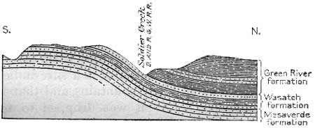
The rocks exposed in the numerous cuts on the new line are generally red or at least are banded with red. These red rocks are the continuation of those that were seen about Colton and are undoubtedly the upper part of the Wasatch formation. The rocks dip to the north (right) at about the same angle as the slope of the mountain side, but the rocks across the ravine on the north side of the old line of the railroad are very white and carry no trace of red material. It is therefore fairly evident, as shown in figure 58, that the rocks in the cuts along the new line belong to the uppermost beds of the Wasatch, and that the white shale and sandstone across the valley are in an overlying formation which geologists have named the Green River formation, from its wide distribution in the Green River Basin, Wyo. This formation is especially prominent at the town of Greenriver, on the Union Pacific Railroad, and forms the picturesque buttes back of the town.
|
| FIGURE 58.—Section at Gliluly, showing relation of the northward-dipping red Wasatch to the white Green River formation. |
The formations in this vicinity are the same as those that the traveler saw in Grand Valley, Colo., between Rifle and De Beque—variegated Wasatch shale at the base and white shale of the Green River formation above it. (See p. 148.)
|
Scenic. Elevation 6,968 feet. Denver 657 miles. Gilluly. Elevation 6,529 feet. Denver 661 miles. |
At the siding of Scenic, 5 miles west of Soldier Summit, the traveler may look down on the north (right) and see not only the old line of the railroad 439 feet below him but also the loop over which he will pass in a few minutes. The difference between a 4 per cent and a 2 per cent grade is here brought out clearly, even to those who are not familiar with the engineering problems of railroad construction. Two miles farther on the road makes a broad loop to the right, still in the Wasatch formation, and returns along the mountain side at a lower level. A reverse loop is made under the old roadbed at the station of Gilluly, and from this point down through the canyon the railroad follows the right wall, but far above the level of the old line.
The rocks which form the mountain side above the tracks and which have been deeply cut in order to provide a roadbed are all in the Green River formation. They are naturally dark, but on weathering they turn intensely white. Experiments have shown that oil in commercial quantity may be distilled from many beds of this shale, and it is possible that gasoline and other grades of oil, as well as fertilizer, may some day be extensively manufactured here.75
75As stated on p. 149, the Green River shale is continuous north of the railroad from Rifle, Colo., to Soldier Summit, Utah. The beds from which oil may be distilled are not so thick in Utah as in Colorado, but recent work done in this region by D. E. Winchester has shown that a great quantity of this shale is available in Utah and that it may yet be a valuable source of petroleum when the fields that are now productive approach exhaustion. The white shale which occurs at Soldier Summit will yield on distillation at least 16.8 gallons of crude oil to the ton.
Where the Green River formation is first seen it dips to the north (right) 25° or 30°, but beyond the curve to the right, above the abandoned station of Tucker, on the old line, the beds are somewhat disturbed, and between mileposts 663 and 664 they are thrown into a well-marked synclinal fold, which may be seen on the right.
The siding of Detour marks the junction of the old and new lines and also the termination of this narrow part of the valley. Below Detour the valley is more open, at least as far as Narrows siding, where it is again constricted by the appearance of harder rocks.
Immediately below Narrows siding the lowest beds of the Green River formation rise downstream, and half a mile beyond milepost 672 the red beds of the Wasatch make their appearance beneath the gray beds of the Green River. The Wasatch is bright red, and the change in color is very striking. This outcrop of the Wasatch is very different in composition from that east of Soldier Summit. There it is generally clay or soft shale; here it is largely a mass of conglomerate composed of boulders of all sorts of rock that occur in the Wasatch Mountains. The presence of such masses of conglomerate made up of boulders of this size is a sure indication that the material was derived from high mountains and that it was not carried far by the streams before it was dropped to form great boulder beds that now are consolidated into massive rock. It therefore seems certain that a high range of mountains once existed in this region when the Wasatch formation was deposited in the early stages of the Tertiary period. This range must have been old as measured by the standard in this mountain region, whereas the present Wasatch Range is supposed to be comparatively young. These statements, however, are not so contradictory as they appear, for most mountain ranges have a complex history, involving many movements up and down, and the Wasatch may not be an exception. It may have had its beginning as a mountain range in early geologic time, but that old range may have been worn down to a rolling plain and later it may have been uplifted into a range like the present Wasatch. In fact, such changes may have occurred several times.
The conglomerate has been a formidable barrier in the pathway of the stream, and it therefore forms a canyon which is scarcely wider than the stream that occupies it and which has given rise to the name "Narrows" for the siding at its upper end. The conglomerate is 700 or 800 feet thick and forms the sides of the valley for several miles. The character of the rock, as well as its brilliant red color, gives to the canyon an individuality that distinguishes it from all the other canyons on the line.
Soldier Creek flows directly west, and the railroad takes a course toward a high mountain peak, one of the southern points of the Wasatch Range, which lies due west of Thistle. The most southerly point of this range is Mount Nebo, a peak which lies so far to the south (left) that it is obscured by the low hills in the foreground.
The appearance of the valley improves in its lower course; more of the ground is irrigated, and there are indications that the train is approaching a town or a railroad junction. Just before reaching the station at Thistle there is a complete change from the soft rocks of the Wasatch formation to the hard blue limestone and red and gray sandstone of the Jurassic system, which form a decided constriction in the width of the valley.
|
Thistle. Elevation 5,033 feet. Population 417. Denver 681 miles. |
The railroad turns abruptly north and is joined at Thistle by a branch line which traverses the rich Sanpete Valley and extends as far south as Marysvale. This valley was early settled by Mormon families sent out from Salt Lake City by Brigham Young for that purpose, in order to protect these outlying settlements as well as those in the Salt Lake Valley, and in 1849, the State of Deseret76 was organized. The organizers passed through much the same experience as those who attempted to organize the State of Jefferson in what is now Colorado, but their motives were obviously quite different. The State of Jefferson was organized to protect the people and their property from the lawless hordes that would be attracted to the country by the discoveries of gold, whereas the State of Deseret was organized to protect and strengthen the Mormon Church by having the machinery of government controlled by the dignitaries of the church.77
76The word "Deseret" is taken from the Book of Mormon and means honey bee. It is written in the Book of Ether of the people who came over the great water from the old world to the new: "And they did also carry with them 'deseret,' which, by interpretation, is a honeybee." The honeybee, or rather the beehive, is one of the important symbols of the Mormon Church, and the word "deseret" is used as the name of the most influential church newspaper, the Deseret News.
77Bancroft, in his History of Utah (pp. 439-440), describes the situation as follows:
"Until the year 1849 the Mormons were entirely under the control of their ecclesiastical leaders, regarding the presidency not only as their spiritual head but as the source of law in temporal matters. Disputes were settled by the bishops, or, as they were also termed, magistrates of wards, appointed by the presidency. The brotherhood discountenanced litigation, but the population did not entirely consist of members of the church. There was already in their midst a small percentage of Gentile citizens gathered from nearly all the civilized nations of the earth. It was probable that, as the resources of the territory were developed, this number would increase in greater ratio, and it was not to be expected that they would always remain content without some form of civil government. Not infrequently litigation arose among the Gentiles, or between Mormon and Gentile; and though strict justice may have been done by the bishops, it was difficult for the latter to believe that such was the case. * * * The Saints regarded their courts as divinely commissioned and inspired tribunals; but not so the Gentiles, by whom reports were freely circulated of what they termed the lawless oppression of the Mormons. Thus it became advisable to establish for the benefit of all some judicial authority that could not be questioned by any, whether members of the church or not, and this authority must be one that, being recognized by the Government of the United States, would have the support of its laws and the shield of its protection. Further than this, if the Mormons neglected to establish such government, the incoming Gentiles would do so ere long."
To accomplish this purpose a convention composed of "the inhabitants of the part of upper California that lies east of the Sierra Nevada Mountains" was called to meet in Salt Lake City on March 4, 1849. A constitution was drafted for the State of Deseret, which was defined as extending from latitude 30° to the border of Oregon, and from the Rocky Mountains to the Sierra Nevada, together with considerable territory that is now within the Republic of Mexico. A general election was held at Salt Lake City on the 12th of March, and Brigham Young was chosen governor of the new State. On July 2 the general assembly convened, and on the next day Willard Snow, being appointed speaker of the house of representatives, administered the oath or affirmation to the executive officers. Bancroft (History of Utah, p. 443) says:
"Thus did the brethren establish, in the valley of the Great Salt Lake, the State of Deseret. It was certainly a novel and somewhat bold experiment on the part of the Saints, mustering then little more than one-sixth of the number required for the admission as a State, thus to constitute themselves a sovereign and independent people, with a vast extent of territory, and calmly await the action of Congress in the matter."
On July 5 Almon W. Babbitt was elected delegate to Congress, and on the next day a memorial to Congress was adopted, asking for admission as a State. Babbitt proceeded to Washington, but Congress refused to recognize him as a delegate from a State which had no legal existence. The Territory of Utah was provided for by an act of Congress September 9, 1850, and President Fillmore appointed Brigham Young its first governor.
Soldier Creek, which the railroad has been following from Tucker, is here joined by Thistle Creek, and together the two streams form the Spanish Fork. The canyon at Thistle is narrow, and its walls are composed of bluish limestone on the east and banded red and gray sandstone or quartzite78 on the west. The blue limestone contains marine shells which show that its age is Jurassic. It normally belongs beneath the Cretaceous rocks, which are so conspicuous along the railroad from Green River nearly to Kyune. Near Thistle the rocks dip steeply to the east, but toward the north the dip decreases until they lie nearly flat. They also change in character, for they become much softer downstream and are composed almost entirely of soft red shale with some beds of sandstone. Beyond milepost 681 this sandstone has been extensively quarried for building stone in Salt Lake City, but the growing use of cement has led to the abandonment of the quarries.
78Quartzite is a term applied to a sandstone that has been changed into a hard, dense flinty rock by the deposition around the sand grains of silica from percolating water carrying material of that kind in solution. A quartzite is much harder than a sandstone, is more resistant to the weather, and is generally nearly pure silica.
Spanish Fork is here joined by Diamond Fork, a stream coming from the northeast (right), which, though rather small, has been utilized by the United States Reclamation Service to bring water from Strawberry River, a tributary of Green River, through a dividing ridge, to irrigate some barren land in Salt Lake Valley.79 The water obtained by damming Strawberry River is carried through the ridge by a long tunnel and discharged into one of the head branches of Diamond Fork. From this point it flows by gravity into Spanish Fork and is diverted lower down, where it is most needed. The traveler may see the diversion canal near the lower end of the canyon.
79The Strawberry Valley diversion (see fig 59) is one of the large projects that the United States Reclamation Service has carried to a successful completion. By this project water that is not needed where it falls is taken over into another drainage basin and given to the thirsty land. As shown on the map (fig. 59) Strawberry River is one of the head branches of Duchesne River (du-shayne'), a stream that enters Green River from the west. Strawberry River heads in rather open country near the Wasatch Range, which has an average elevation of about 8,000 feet above sea level. At that altitude the cultivation of any but the most hardy grains and vegetables is impossible, so that the water is of little value where it falls, but over the mountains on the west there is not sufficient water to irrigate all the land that is well adapted to farming. The problem, therefore, was to bring the water of Strawberry River across the divide to the lands that needed it so greatly. To accomplish this feat a dam 72 feet high was built across Strawberry River at a place called the "Narrows," a constricted point in the valley below a part that is open and well adapted to form a reservoir. A tunnel was then driven from one of the tributaries of Strawberry River through the divide for a distance of 19,897 feet (nearly 4 miles), so as to allow the water of the reservoir to flow through and discharge into the head of Diamond Creek, a tributary of Spanish Fork. The water flows down Spanish Fork to the west side of the Wasatch Mountains, where it is again diverted into a canal for utilization, first for the development of electric power and later for irrigation. The hydroelectric plant is 3-1/2 miles below the diversion dam in Spanish Fork, and the power is generated by dropping the water to the level of that stream, as shown in Plate LXXXIX, B. The water is then carried to the south end of Utah Lake and distributed to the land at that place and also on the east side. This land has been partly settled since 1847 but has not been fully developed because of the shortage of water. The supply from Strawberry Valley will be sufficient to irrigate about 54,000 acres of this land, and thus a great addition to the productive power of the State is made at the expense of a very slight loss to that part from which the water is taken.
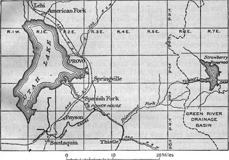
FIGURE 59.—Map of Strawberry Valley reclamation project. The dash line shows the boundary of the Green River drainage basin.
|
|
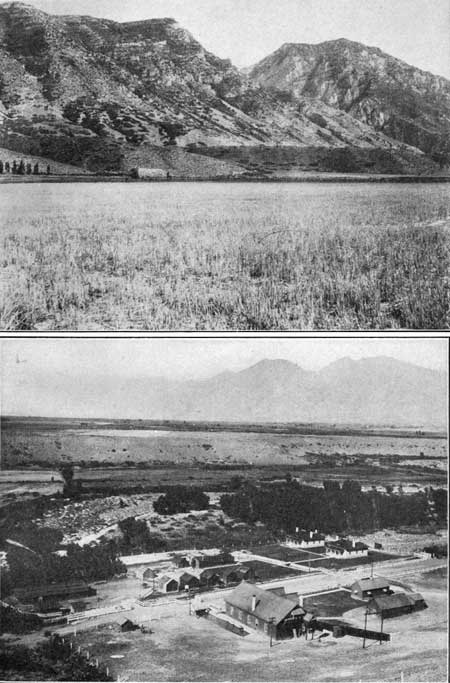
PLATE LXXXIX. A (top). BONNEVILLE SHORE LINE.
Lake Bonneville shore line as it is marked on the west face of the
Wasatch Mountains at the mouth of Hobble Canyon, back of Springville.
Above this line the rocks are bare, and there is no trace of wave
action; below it the slopes are covered with mud washed into the lake
when it stood at this height. Photograph by G. B. Richardson. B (bottom). HYDROELECTRIC PLANT OF THE STRAWBERRY VALLEY RECLAMATION PROJECT. After the water of Strawberry valley is carried by a long tunnel through the Wasatch Mountains into Spanish Fork it is diverted into a canal and dropped several hundred feet to the plant shown in this view. The electric power which it generates is sold to near-by towns, and the water is then used for irrigating the land. Photograph by the U. S. Reclamation Service. |
|
Castilla. Elevation 4,912 feet. Denver 685 miles. |
The Triassic red beds extend nearly a mile west of the mouth of Diamond Creek, to a place where they are probably terminated by a fault which separates them from the Carboniferous and older rocks that form the core of the Wasatch Range. The rocks of the mountains are of Carboniferous age but are so poorly exposed and so complicated in structure that it is useless to attempt to describe them. From some limestones of this formation comes the hot sulphur water which has made Castilla (cas-tee'yah) Hot Springs a noted resort.
The Wasatch Mountains, although not equal in height to the Rocky Mountains of Colorado or the Sierra Nevada of California, are nevertheless one of the dominating ranges of the continent, and their peaks range in elevation from 10,000 to more than 12,000 feet. The impressiveness of the range is due more to its situation than to its elevation, but both unite to make it a noteworthy group of mountains. During the great ice age this range supported a number of glaciers (see the map opposite p. 244), but the glaciers were neither so large nor so numerous as those of the Rocky Mountains.
Since leaving Canon City the traveler has been either in the Rocky Mountains or in what is generally known as the Plateau country, so called because it is made up of a series of plateaus of different elevations, but when he passes through this canyon and emerges on the west front of the Wasatch Range he finds himself in a country that is very different from any that he has yet seen on this journey. This region is known as the Great Basin, a land of desert basins and of barren mountain ranges, which in general trend north and south. The precipitation here is slight, ranging in this latitude from 5 to 8 inches, and that which falls finds its way into some deep basin in the interior like Great Salt Lake, where the water, when it evaporates, leaves the mineral matter that is carried in solution to form beds of salt or soda.
The walls of the canyon, although steep, are generally smooth and are covered, except in the higher parts, by brush and dwarf trees of many kinds. In summer they are clothed in a soft, beautiful green, with here and there an evergreen tree to accentuate the softness of the foliage of the other trees, but in September, after the frost has touched the dwarf maples of the higher slopes, the coloring is magnificent. Many of the slopes are a blaze of scarlet from top to bottom, and others show scarlet interspersed with brown and green. The clumps of aspen give the landscape a touch of gold, and the whole scene presents an unexcelled splendor of autumn colors.
The canyon grows broader to the west, and the railroad is built along its north wall. On the opposite side, near milepost 687, is the headgate where the water of Spanish Fork, including that from Strawberry River, is diverted into a large canal, which is soon lost to view as it follows the south wall of the canyon to the mouth and there turns to the left to the area where its waters are most needed.
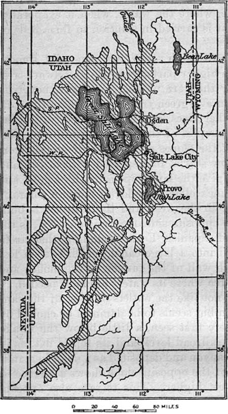
The outlet of the canyon is not like the outlets of most of the canyons that the traveler has seen but seems to be dammed or choked by a great mass of gravel. Where first seen, a little below the intake of the canal, the gravel is at railroad level, and its top is flat, as if it had been washed down the canyon and deposited as a delta in standing water. An examination of the opposite slope shows a terrace of similar material about 100 feet higher. This terrace also appears to have had a similar history, except that as it is the older of the two deposits most of its gravel was washed away when the second terrace was formed, and so only fragments remain where they have been protected on the side slopes. These terraces are of the greatest significance in the interpretation of the late geologic history of this region; to the geologist they have much the same value that the cliff dwellings or tables of cuneiform writing have to the archeologist. They constitute the record of one of the most remarkable geologic events in this country—the flooding of the basin of Great Salt Lake during the ice age to a depth of more than a thousand feet. When these terraces in the Spanish Fork canyon were formed the water of Lake Bonneville, as it has been called to distinguish it from the present lake, entered the mouth of the canyon at the level of the highest terrace, and if a traveler had then attempted to make a westward journey here he would have been confronted by an inland fresh-water sea that extended from the Wasatch Mountains to the west line of the State.80 (See fig. 60.)
|
| FIGURE 60—Map of Lake Bonneville (the area indicated by diagonal shading). |
80The Bonneville shore lines and broad flats that the traveler has already seen at the mouth of Spanish Fork canyon and the others that he will see before he reaches Salt Lake City will doubtless convince him that at some time long ago the drainage basin of which the present Great Salt Lake occupies only the deeper part was filled with water to the highest shore line, or about 1,000 feet. This old and vanished lake has been named Lake Bonneville, in honor of Capt. B. L. E. Bonneville, who in 1832 to 1836 explored much of the region formerly occupied by its waters.
The late G. K. Gilbert, who was recognized as the leading authority on the history of Lake Bonneville, said, in speaking of the highest shore line (U. S. Geol. Survey Mon. 1, pp. 94-99, 1890):
"If the Bonneville shore line were far less deeply engraved than it is it would still be conspicuous by reason of its position. As it is, no geologic insight is necessary to discover it, for it is one of the pronounced features of the country. It confronts all be holders and insists on recognition. The tourist who visits Ogden and Salt Lake City by rail sees it on the Wasatch [Mountains] and on the islands of Great Salt Lake and makes note of it as he rides. The farmer who tills the valley below is familiar with it and knows that it was made by water; and even the cowboy, finding an easy trail along its terrace as he 'rides the range,' relieves the monotony of existence by hazarding a guess as to its origin."
Gilbert followed this shore line, studied it in detail, and mapped it throughout most of its sinuous course. The map copied from his report (see fig. 60) shows the greatest extent of Lake Bonneville as compared with the present Great Salt Lake.
The history of Lake Bonneville goes back to a time before man was known on the globe, or possibly about to the time of his first appearance, but in any event the conditions that led to the formation of that great body of water could not have been due to man's activities and hence must have been the result of climatic change. Gilbert (U. S. Geol. Survey Bull. 612, pp. 96-97, 1915) gives the history of Lake Bonneville as follows:
"The latest of the periods into which geologists divide past time witnessed a series of climatic changes which affected the whole earth, and * * * the element which recorded its changes most clearly was temperature. There were several epochs of cold, and they were separated by epochs of warmth. During the cold epochs the high parts of the Wasatch Range held a system of glaciers, and in one of them several ice tongues protruded so far beyond the mouths of the mountain canyons that they heaped their moraines on the floor of Jordan Valley, only a few miles from the place where Salt Lake City now stands. In that epoch of cold the rate of evaporation was far slower than now, and evaporation was at so great a disadvantage in its contest with precipitation that there was immense expansion of the water surface. When the lake was largest it was comparable in area and depth with Lake Michigan; It had eleven times its present extent. In attaining this great expanse the water surface rose to a position more than 1,000 feet above its present level.
"To this great body of water geologists apply a distinctive name—Lake Bonneville—and they have given much attention to its history, which is written in shore lines, deltas, channels, deposits, and fossils. The shore lines [Pls. LXXXIX, A, and XCVI, B] appeal most to the traveler and may be seen from car windows at several points.
"As a matter of definition a shore is merely the meeting place of land and sea, or of land and lake, but as a matter of land form it is much more. At the shore the lashing of storm waves works changes in the land, giving it new shapes. At some places the land is carved away; at others it is made to encroach on the water. Where it is eroded the limit of erosion is marked by a cliff, and below the water is a shelf of gentle slope. Where additions are made they take the form of beaches or bars, which rise little above the water level and are composed of sand or gravel. At some places a bar spans a bay from side to side; elsewhere it is incomplete, projecting from a headland as a spit.
"The waves of Lake Bonneville were as powerful as those of Lake Michigan and fashioned the shore into an elaborate system of cliffs, beaches, and spits, and when the waters finally fell to the lower levels they left behind the shapes their waves had made. The base of each surviving shore cliff is a horizontal line, and so is the crest of each beach, bar, and spit, and these features in combination trace the outline of the old lake as a level contour about the sides of the basin and the faces of mountains that were once islands in the lake.
"In rising and falling the waters lingered at many levels, and so there are many ancient shore lines, but two of them are more conspicuous than the rest and have been named. The highest of all is the Bonneville shore line, and 375 feet lower lies the Provo shore line. The Bonneville line represents a relatively short stand of the water and is conspicuous chiefly because it marks the upper boundary of wave action. All the slopes below it have been more or less modified by the waves, but the slopes above it retain the shapes which had been given them by other agencies. The Provo line represents a long stand of the water and is conspicuous because it is strongly sculptured.
"In all the early history of the great lake its basin was closed, like that of the modern lake. The water, surface rose and fell in response to climatic changes like that of its modern remnant. The last great rising was the highest and terminated the series of oscillations by creating an outlet. The lowest point of the basin's rim was at Red Rock Pass [130 miles by rail north of Salt Lake City], and when the water rose above that level the stream which began to cross the pass descended to Portneuf River, a tributary of Snake River, the chief branch of the Columbia. Through the creation of this outlet the Bonneville Basin, which had previously contained an independent interior drainage system, became part of the drainage system of the Pacific Ocean. * * *
"The formation at the summit [of Red Rock Pass] consisted of soft earth, and as soon as overflow began a channel was formed. The deepening of the channel increased the volume of the stream by lowering the outlet of the lake; the greater stream was more efficient in deepening the channel, and these two causes interacted until the stream became a stupendous torrent. The volume of water discharged before the flow became steady was enough to supply Niagara River for 25 years, but the record of the torrent's violence leads to the belief that it lasted for a much shorter period. * * *
"The draining of the lake down to the Provo level reduced its area by one-third and correspondingly reduced the quantity of water annually evaporated. Two-thirds of the inflowing water was then disposed of by evaporation, and the remainder was discharged through the outlet. Only a great change of climate could restore the balance between inflow and evaporation, and the change was slow in completion. At last, however, the pendulum of temperature swung far enough on the side of warmth. The outlet channel ran dry, the lake basin was again separated from the drainage system of the Pacific, and the lake began to shrink. So long as there was outflow the water was fresh, but when the outflow ceased there began that accumulation of salt which has made the water of the present lake a concentrated brine.
"At times in the history of the lake, especially while the Provo shore line was being formed, the tributary streams brought down sand and gravel, which they dropped at their mouths, building deltas. When the water fell these deposits remained as fan-shaped benches having steep fronts. The streams that built them then dug channels through them. * * *
"In quality of water and in temperature Lake Bonneville was as well fitted for abundant and varied life as the Bear Lake to-day, and though the only remains yet found in its sediments are fresh-water shells, we need not doubt that its waters teemed with fish. We may confidently picture its bordering marshes as fields of verdure and its bolder shores as forest clad; and we may less confidently imagine primitive man as a denizen of its shores and an eyewitness of the spectacular deluge when its earthen barrier was burst."
Some of the most prominent of these old shore lines have been named. The highest, the one Visible as a terrace about 100 feet above the track, is called the Bonneville shore line. The one at railroad level, which has not been named, represents a later stage of water, when the northern outlet had been cut down below its first position but not so low as it became later. It probably records the position of a harder bed of rock, which the outflowing waters encountered when they had partly cut the barrier that held them in place, and this hard bed held the stream so long that it permitted Spanish Fork to build at this height a delta of considerable extent.
In its descent to the lower level of the valley the railroad cuts deeper and deeper into the delta, and finally, near milepost 689, it comes out on a still lower plain, which represents a later and lower stand of the waters. This plain is extensive, and from its even surface the traveler may get his first general view of the Great Salt Lake basin. Originally this plain was only a desert, but now it is dotted with farms, each protected by a line of tall poplars that may be seen far across the valley. Utah Lake, a body of fresh water 30 miles long and 6 to 10 miles wide, lies in the middle of the basin, and beyond it are the barren slopes of the Oquirrh Mountains (o'queer). Most of these desert ranges are not very high, but they are striking features, for they rise, island-like, out of a wide expanse of desert.
|
Mapleton. Elevation 4,724 feet. Population 586. Denver 691 miles. |
The plain upon which the railroad is built is another of the numerous unnamed terraces that mark the shore line of Lake Bonneville and represent pauses of longer or shorter duration in the gradual lowering of the water in the basin. This is well developed about the station of Mapleton. The view from the railroad at this point is particularly fine because it embraces what appears to be the bottom of the valley, so wide is it and so completely cultivated. On the right stands the great blank wall of the mountains, across whose front the Bonneville shore line (see Pl. LXXXIX, A) can be seen as a mere thread separating the slopes above—characterized by gashes cut by streams—from those below, in which all roughness and angularity have been concealed by the material deposited in the ancient lake. Along the foot of the slope, within the irrigated lands, stretches a belt of sloping plain on which most of the homes of the region are built. Each house has its protecting row of slender poplar trees, which give the scene an aspect so foreign that one seeing it might almost imagine himself on the plains of northern Italy looking at the slopes of the Alps, instead of in the Salt Lake Valley looking at the slopes of the Wasatch Mountains.
The abrupt change from the steep slope of the mountain front to the nearly flat surface of the desert plain, except where deltas and bars were built in the waters of old Lake Bonneville, is very striking and doubtless will attract the attention of many travelers. The traveler sees no foothills, no indication of a mountain front, until he reaches the foot of the slope. What does the abrupt change from mountain to plain mean, and has it any connection with the geologic history of the region? It assuredly has a meaning, and the processes that produced these mountains have had a most striking effect in determining not only the surface features of this region but its climate and its arid conditions. Long ago, as man measures time, the rocks composing the crust of the earth broke along a line that now coincides with the west front of the Wasatch Range, and the part on the east side of that break or fault was forced up many thousand feet, or the part on the west was dropped an equal distance, or both movements took place to a lesser degree. It matters not which side moved, for in any event the part east of the fault now forms mountains because it was uplifted relative to the other, or the other is now a low basin because it was depressed relative to the part on the east.81 Although the principal movement probably took place long ago, slight movements have occurred so recently that they have broken across alluvial cones formed by small streams flowing out of the mountains.
81The entire Great Basin, which extends from the Wasatch Range on the east to the Sierra Nevada on the west, is characterized by faulted mountains like the Wasatch. Such mountains are generally known as "block mountains," for the reason that the crust of the earth has been broken into great blocks by the faults and later these blocks have been tilted in different directions. In the central part of the basin the faults and consequently the block mountains trend north and south, as may be seen on any good map of the region. The beds of rock of which such a mountain is composed may originally have had a simple structure or they may have been folded and broken in a most complex manner. But no matter how complex the folding the block has acted as a unit and has been tilted in the same manner as the horizontal rocks.
In the tilting the edge of the great block that was elevated produced a mountain and the edge that was depressed formed a deep basin, which later was partly filled by sand and gravel washed in from the surrounding slopes. In many places the loose rock filling has a depth of more than a thousand feet. Such a basin is generally deepest in the center, and the slight precipitation that falls on the surrounding slopes finds its way to the lowest point, where it forms a shallow lake, but the water is soon carried off by evaporation and there remains in its place only a dry lake bed, known in the Southwest by the Spanish name of "playa." The entire basin is also frequently spoken of as a "bolson" (bowl-sown'), a Spanish name meaning purse, which has been applied to the basin because it resembles in shape a Spanish purse.
Great Salt Lake is said to lie in such a basin, though it really lies in several basins, which are so shallow that the water extends from one to the other. In time of drought it too would disappear were it not for the large supply of water it receives from the high ranges on the east.
| <<< Previous | <<< Contents >>> | Next >>> |
bul/707/sec6b.htm
Last Updated: 16-Feb-2007