
|
Geological Survey Bulletin 1493
The Geologic Story of the Great Plains |
LANDFORMS OF TODAY—THE SURFACE FEATURES OF THE GREAT PLAINS
The mountainous sections of the Great Plains were formed long before the remaining areas were outlined by erosion. Uplift of the Black Hills and the Central Texas Uplift began as the continental interior was raised and the last Cretaceous sea was displaced, 65 to 70 million years ago. They stood well above the surrounding plains long before any sediments from the distant Rocky Mountains began to accumulate at their bases. In southern Colorado and northern New Mexico, molten rock invaded the sedimentary layers between 22 and 26 million years ago. The Spanish Peaks were formed at this time from hot magma that domed up the surface layers but did not break through; the magma has since cooled and solidified and has been exposed by erosion. Elsewhere the magma reached the surface, forming volcanoes, fissures, and basalt flows. A great thickness of basalt flows accumulated at Raton Mesa and Mesa de Maya between 8 and 2 million years ago. Volcanism has continued intermittently, and the huge cinder cone of Capulin Mountain was created by explosive eruption only 10,000 to 4,000 years ago. Most of these volcanic masses were formed before major downcutting by the streams began. Other igneous intrusions and volcanic areas in the northern Great Plains similarly were formed before the streams were incised.
To examine the origin of the present landscape and of the landforms typical of the various sections of the Great Plains, it is convenient to begin with the Black Hills, the Central Texas Uplift, and the Raton section simply because they were formed first—they existed before the other sections were outlined.
Black Hills
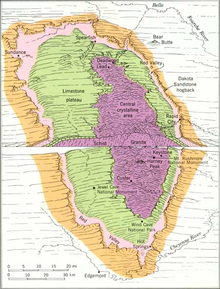
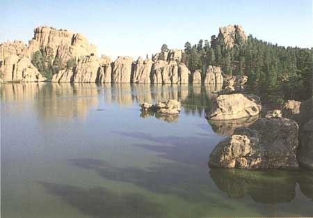
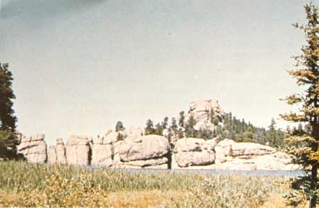
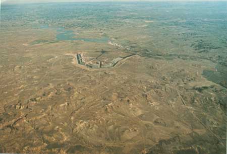
The Black Hills is a huge, elliptically domed area in northwestern South Dakota and northeastern Wyoming, about 125 miles long and 65 miles wide (fig. 10). Rapid City, S. Dak., is on the Missouri Plateau at the east edge of the Black Hills. Uplift caused erosion to remove the overlying cover of marine sedimentary rocks and expose the granite and metamorphic rocks that form the core of the dome. The peaks of the central part of the Black Hills presently are 3,000 to 4,000 feet above the surrounding plains. Harney Peak, with an altitude of 7,242 feet, is the highest point in South Dakota. These central spires and peaks all are carved from granite and other igneous and metamorphic rocks that form the core of the uplift. The heads of four of our great Presidents are sculpted from this granite at Mount Rushmore National Memorial. Joints in the rocks have controlled weathering processes that influenced the final shaping of many of these landforms. Closely spaced joints have produced the spires of the Needles area, and widely spaced joints have produced the rounded forms of granite that are seen near Sylvan Lake (fig. 11).
|
| Figure 10.—Diagram of the Black Hills uplift by A. N. Strahler (Strahler and Strahler 1978). Used by permission. |
|
| Figure 11.—Jointed granite rounded by weathering at Sylvan Lake, in the central part of the Black Hills, S. Dak. Photo courtesy of South Dakota Tourism. |
Marine sedimentary rocks surrounding the old core rocks form well-defined belts. Lying against the old core rocks and completely surrounding them are Paleozoic limestones that form the Limestone Plateau (fig. 10). These tilted layers have steep erosional scarps facing the central part of the Black Hills. Wind Cave and Jewel Cave were produced by ground water dissolving these limestones along joints. These caves are sufficiently impressive to be designated as a national park and a national monument, respectively. Encircling the Limestone Plateau is a continuous valley cut in soft Triassic shale. This valley has been called "the Racetrack," because of its continuity, and the Red Valley, because of its color. Surrounding the Red Valley is an outer hogback ridge formed by the tilted layers of the Dakota Sandstone, which are quite hard and resistant to erosion. Streams that flow from the central part of the Black Hills pass through the Dakota hogback in narrow gaps.
The Black Hills, then, is an uplifted area that has been carved deeply but differentially by streams to produce its major outlines. Those outlines have been modified mainly by weathering of the ancient core rocks and solution of the limestone of the Limestone Plateau.
Central Texas Uplift
The domed rocks of the Central Texas Uplift form a topography different from that of the Black Hills. Erosion of a broad, uplifted dome here has exposed a core of old granites, gneisses, and schists, as in the Black Hills, but in the Central Texas Uplift, erosion has produced a topographic basin, rather than high peaks and spires, on the old rocks of the central area. A low plateau surface dissected into rounded ridges and narrow valleys slopes gently eastward from the edge of the central area to an escarpment at the Balcones fault zone, which determines the eastern edge of the Great Plains here. Northwest of the central basin the Colorado River flows in a broad lowland about 100 miles long, but the northern edge of the uplift, forming a divide between the Brazos and the Colorado Rivers, is a series of mesas formed of more resistant sandstone and limestone.
The cutting action of streams, modified or controlled in part by differences in hardness of the rock layers, has been responsible for the landforms of the Central Texas Uplift. Weathering of the old core rocks has softened them sufficiently to permit deeper erosion of the central area, and solution of limestone by ground water has formed such features as Longhorn Caverns, 11 miles southwest of Burnet, Tex.
Raton Section
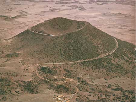
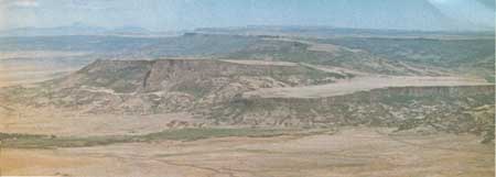
Volcanism characterizes the Raton section. The volcanic rocks, which form peaks, mesas, and cones, have armored the older sedimentary rocks and protected them from the erosion that has cut deeply into the adjoining Colorado Piedmont to the north and Pecos Valley to the south. The south edge of the Raton section is marked by a spectacular south-facing escarpment cut on the nearly flat-lying Dakota Sandstone. This escarpment is the Canadian escarpment, north of the Canadian River. Northward for about 100 miles, the landscape is that of a nearly flat plateau cut on Cretaceous rock surmounted here and there by young volcanic vents, cones, and lava fields. Capulin Mountain is a cinder cone only 10,000 to 4,000 years old (fig. 12). Near the New Mexico-Colorado border, huge piles of lava were erupted 8 to 2 million years ago onto an older, higher surface on top of either the Ogallala Formation of Miocene age or the Poison Canyon Formation of Paleocene age. (See table 1.) These lava flows formed a resistant cap, which protected the underlying rock from erosion while all the surrounding rock washed away. The result is the high, flat-topped mesas, such as Raton Mesa and Mesa de Maya (fig. 13), that now form the divide between the Arkansas and Canadian Rivers. At Fishers Peak, on the west end of Raton Mesa, about 800 feet of basalt flows rest on the Poison Canyon Formation at about 8,800 feet in altitude. Farther east, on Mesa de Maya, about 400 feet of basalt flows overlie the Ogallala Formation at altitudes ranging from about 6,500 feet at the west end to about 5,200 feet at the east end, some 35 miles to the east. The Ogallala here rests on Cretaceous Dakota Sandstone and Purgatoire Formation, for the Poison Canyon Formation was removed by erosion along the crest of a local uplift before the Ogallala was deposited.
|
| Figure 12.—Capulin Volcano National Monument in northeastern New Mexico. This huge cinder cone, which erupted between 4,000 and 10,000 years ago, rises more than 1,000 feet above its base. Photograph by R. D. Miller U.S. Geological Survey. |
|
| Figure 13.—Lava-capped Mesa de Maya, east of Trinidad, Colo, Spanish Peaks in left distance. Mesa rises about 1,000 feet above surrounding area. Photograph by R. B. Taylor U.S. Geological Survey. |
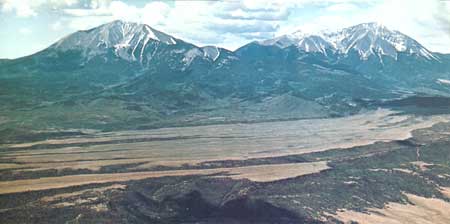
East of the belt of upturned sedimentary layers that form the hogback ridges at the front of the Rocky Mountains, the layered rocks in the Raton Basin have been intruded in many places by igneous bodies, the two largest of which form the Spanish Peaks (fig. 14), southwest of Walsenburg, Colo. These two peaks are formed by igneous bodies that were intruded 26 to 22 million years ago and have since been exposed by removal of the overlying sedimentary rock layers by erosion. Radiating from the Spanish Peaks are hundreds of dikes, nearly vertical slabs of igneous rock that filled fractures radiating from the centers of intrusion. Erosion of the sedimentary layers has left many of these dikes as conspicuous vertical walls of igneous rock that project high above the surrounding land surface. Some of these dikes north of Trinidad, Colo, extend eastward for about 25 miles, almost to the Purgatoire River.
|
| Figure 14.—Spanish Peaks, southwest of Walsenburg, Colo. Igneous intrusive rocks and many radiating dikes exposed by erosion. Photograph by R. B. Taylor, U.S. Geological Survey. |
The northern boundary of the Raton section is placed somewhat indefinitely at the northern limit of the area injected by igneous dikes. The eastern boundary of the Raton section is at the eastern margin of the lavas of Mesa de Maya and adjoining mesas, where lava-capped outliers of Ogallala Formation are separated from the Ogallala of the High Plains only by the canyon of Carrizo Creek.
High Plains
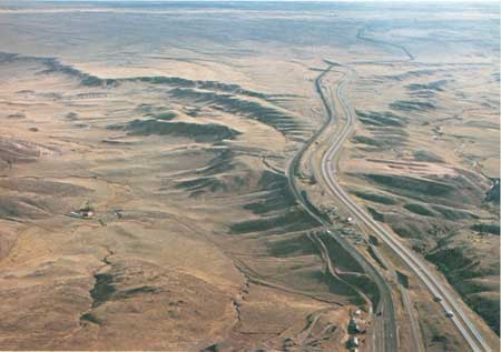
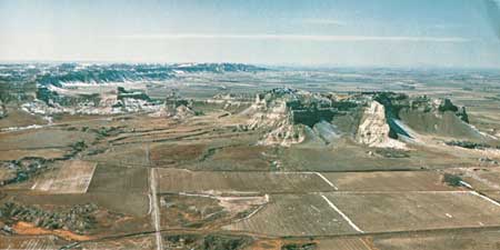
A the end of Ogallala deposition, some 5 million years ago, the Great Plains, with the exception of the uplifted and the volcanic areas, was a vast, gently sloping plain that extended from the mountain front eastward to beyond the present Missouri River in some places. Regional uplift of the western part of the continent forced the streams to cut downward; land near the mountains were stripped away by the Missouri, the Platte, the Arkansas, and the Pecos Rivers, and the eastern border of the plains was gnawed away by lesser streams. A large central area of the plain is preserved, however, essentially untouched and unaffected by the streams, as a little-modified remnant of the depositional surface of 5 million years ago. This Ogallala-capped preserved remnant of that upraised surface is the High Plains. In only one place does that old surface still extend to the mountains—at the so-called "Gangplank" west of Cheyenne, Wyo. (fig. 15) In places, as at Scotts Bluff National Monument, Nebr. (fig 16), small fragments of this surface have been isolated from the High Plains by erosion and now stand above the surrounding area as buttes.
|
| Figure 15.—Looking eastward toward Cheyenne at "the Gangplank." Interstate Highway 80 and the Union Pacific Railroad follow the Gangplank from the High Plains in the distance onto the Precambrian rocks (older than 570 m.y.) of the Laramie Mountains in the foreground. Photograph by R. D. Miller U.S. Geological Survey. |
|
| Figure 16.—Aerial view of the Scotts Bluff National Monument, Nebr. Buttes on the south side of the valley of the North Platte River isolated by erosion from High Plains in the background. Highest butte stands about 800 feet above valley floor. |
The High Plains extends southward from the Pine Ridge escarpment, near the South Dakota-Nebraska border (fig. 3), to the Edwards Plateau in Texas. The Platte, the Arkansas, and the Canadian Rivers have cut through the High Plains. That part of the High Plains south of the Canadian River is called the Southern High Plains, or the Llano Estacado (staked plain). The origin of this name is uncertain, but it has been suggested that the term Llano Estacado was applied by early travelers because this part of the High Plains is so nearly flat and devoid of landmarks that it was necessary for those pioneers to set lines of stakes to permit them to retrace their routes.
The Llano Estacado is bounded on the west by the Mescalero escarpment (fig. 4) and on the east by the Caprock escarpment. The southern margin with the Edwards Plateau is less well defined, but King Mountain, north of McCamey, Tex., is a scarp-bounded southern promontory of the High Plains. The remarkably flat surface of the Llano Estacado is abundantly pitted by sinks and depressions in the surface of the Ogallala Formation; these were formed by solution of the limestone by rainwater and blowing away or deflation by wind of the remaining insoluble particles. Many of these solution-deflation depressions are aligned like strings of beads, suggesting that their location is controlled by some kind of underlying structure, such as intersections of joints in the Ogallala Formation.
The solution-deflation depressions are less abundant north of the Canadian River, but occur on the High Plains surface northward to the Arkansas River and along the eastern part of the High Plains north of the Arkansas to the South Fork of the Republican River.
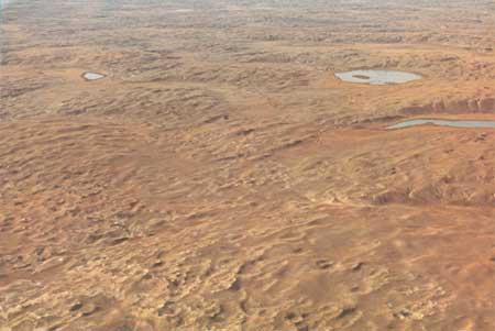
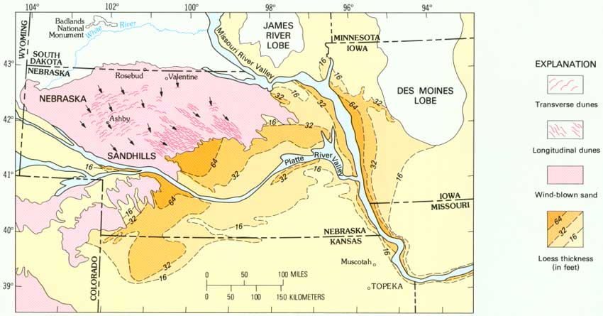
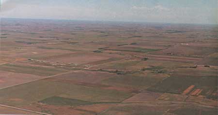
Covering much of the northern High Plains, however, are sand dunes and windblown silt deposits (loess) that mantle the Ogallala Formation and conceal any solution-deflation depressions that might have formed. The Nebraska Sand Hills (fig. 17), the largest area of sand dunes in the western hemisphere, is a huge area of stabilized sand dunes that extends from the White River in South Dakota southward beyond the Platte River almost to the Republican River in western Nebraska but only to the Loup River in the northeast part of the High Plains (fig. 18). Loess covers the western High Plains southward from the sand dunes almost to the Arkansas River, and to the South Fork of the Republican in the eastern part. This extensive cover of loess has created a fertile land that makes it an important part of America's wheatlands (fig. 19).
|
| Figure 17.—Aerial view, looking northwest, of the Nebraska Sand Hills west of Ashby, Nebr. |
|
| Figure 18.—The Sand Hills Region of Nebraska. Arrows show inferred direction of dune-forming winds. Map from Wright (1970), used by permission. (click on image for an enlargement in a new window) |
|
| Figure 19.—Little-modified loess plain in southeastern Nebraska. Photograph by Judy Miller. |
Other, smaller areas of sand dunes lie south of the Arkansas River valley. The only large areas of sand dunes on the Llano Estacado, or Southern High Plains, are along the southwestern margin near Monahans, southwest of Odessa, Tex.
Oil and gas are present in the Paleozoic rocks that underlie the High Plains at depth. Gas fields are ubiquitous in much of the eastern part of the High Plains between the Arkansas and Canadian Rivers. Just south of the Canadian River, at the northeast corner of the Southern High Plains, a huge oil and gas field has been developed near Pampa, Tex. Oil and gas fields also are abundant in the southwestern part of the Southern High Plains, south of Littlefield, Tex.
The surface of the High Plains, then, has been little modified by streams since the end of the Ogallala deposition. It has been raised by regional uplift and pitted by solution and deflation, and large parts of it have been covered by wind-blown sand and silt. It has been drilled for oil and gas and extensively farmed, but it is still a geological rarity—a preserved land surface that is 5 million years old.
Missouri Plateau
Beginning about 5 million years ago, regional uplift of the western part of the continent forced streams, which for 30 million years had been depositing sediment nearly continuously on the Great Plains, to change their behavior and begin to cut into the layers of sediment they so long had been depositing. The predecessor of the Missouri River ate headward into the northern Great Plains and developed a tributary system that excavated deeply into the accumulated deposits near the mountain front and carried away huge volumes of sediment from the Great Plains to Hudson Bay. By 2 million years ago, the streams had cut downward to within a few hundred feet of their present level. This region that has been so thoroughly dissected by the Missouri River and its tributaries is called the Missouri Plateau.
About 2 million years ago, after much downcutting had already taken place and river channels had been firmly established, great ice sheets advanced southward from Canada into the United States. (See figure 2.) These continental glaciers formed, advanced, and retreated several times during the last 2 million years. At the north and east margins of the Missouri Plateau they lapped onto a high area, leaving a mantle of glacial deposits covering the bedrock surface and forcing streams to adopt new courses along the margin of ice. The part of the Missouri Plateau covered by the continental glaciers now is referred to as the Glaciated Missouri Plateau. South of the part once covered by ice is the Unglaciated Missouri Plateau.
Preglacial Drainage
Before the initial advance of the continental ice sheets, the Missouri River flowed northeastward into Canada and to Hudson Bay. Its major tributaries, the Yellowstone and the Little Missouri joined the Missouri in northwestern North Dakota. The east-flowing Knife, Heart, and Cannonball Rivers in North Dakota also joined a stream that flowed northward to Hudson Bay.
Glaciated Missouri Plateau
When the continental ice sheets spread southward into northern Montana and the Dakotas, a few isolated areas in Montana stood above the surrounding plain. These are mostly areas that were uplifted by the intrusion of igneous bodies long before the streams began downcutting and carving the land. The northernmost of these isolated mountains, the Sweetgrass Hills, were surrounded by ice and became nunataks, or islands of land, in the sea of advancing ice, which pushed southward up against the Highwood Mountains, near Great Falls, the Bearpaws south of Havre, and the Little Rockies to the east.
Much of the northern part of Montana is a plain of little relief that is the surface of a nearly continuous cover of glacial deposits, generally less than 50 feet thick. This plain has been incised by the east-flowing postglacial Teton, Marias, and Milk Rivers.
In North Dakota, a high area on the east side of the Williston basin acted as a barrier to the advance of the ice, most of which was diverted southeastward. The margin of the ice sheet, however, lapped onto the bedrock high, where it stagnated. Earlier advances moved farthest south; the later advances stopped north of the present course of the Missouri River—their maximum position marked by ridges of unsorted, glacially transported rock debris (till) called terminal moraines. North of the terminal moraines is a distinctive landscape characterized by a rolling, hummocky, or hilly surface with thousands of closed depressions between the hills and hummocks, most of them occupied by lakes. This is the deposit left by the stagnant or dead ice, and it is called dead-ice moraine. The rolling upland in North Dakota that is covered by dead-ice moraine and ridges of terminal moraine from the last glacial advances is called the Coteau du Missouri (fig. 20). A gently sloping scarp, several hundred feet high and mostly covered by glacial deposits (referred to collectively as drift), separates the Coteau du Missouri from the lower, nearly flat, drift-covered plains of the Central Lowland to the east. This escarpment, which is called the Missouri escarpment, is virtually continuous across the State of North Dakota southward into South Dakota. The base of the Missouri escarpment is the eastern boundary of the Great Plains in these northern states.
|
| Figure 20.—Ground moraine on the Coteau du Missouri, northwestern North Dakota. Photograph by R.M. Lindvall, U.S. Geological Survey. |
The advancing ice front blocked one after another of the northward-flowing streams of the region, diverting them eastward along the ice front. Shonkin Sag, north of the Highwood Mountains near Great Falls, Mont., is an abandoned diversion channel of the Missouri River, occupied when the ice front stood close to the north slopes of the Highwoods. Much of the present course of the Missouri River from Great Falls, Mont., to Kansas City, Mo., was established as an ice-marginal channel, and the east-flowing part of the Little Missouri River in North Dakota was formed in the same way. These valleys were cut during the last 2 million years.
The north-flowing part of the Little Missouri River and the east-flowing courses of the Knife, Heart, and Cannonball Rivers in North Dakota are for the most part older, preglacial courses. The Little Missouri was dammed by the ice, and its waters impounded to form a huge lake during the maximum stand of the ice, but the deposits of this glacial lake are few and make no imprint on the landscape.
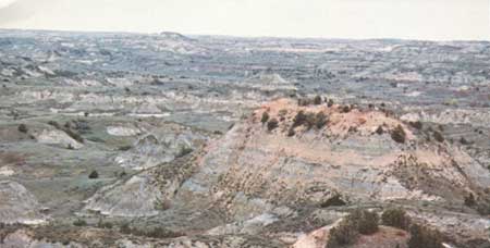
The valley of the east-flowing, glacially diverted part of the Little Missouri River, however, is markedly different from that of the north-flowing preglacial river. It is much narrower and has steeper walls than the old valley. Because it is younger, it is little modified, except by huge landslides that have affected both walls of the valley. Tremendous rotated landslide blocks in the North Unit of Theodore Roosevelt National Park are some of the best examples of the slump type of landslide to be seen anywhere (fig. 21).
|
| Figure 21.—Rotated slump blocks in huge landslide, North Unit of Theodore Roosevelt National Park, N.Dak. Note that layering of Fort Union Formation in cliffs on skyline, where landslide originated, is horizontal. |
Melting ice at the front of the glaciers provided large volumes of meltwater that flowed across the till-mantled surface in front of the glacier as it melted back toward Canada. This meltwater took many courses to join the glacially diverted Missouri River, and these sinuous meltwater channels wind across the dead-ice moraine and the older, less hummocky ground moraine between the Coteau du Missouri and the Missouri River. Locally the sediment carried by the meltwater streams was banked against a wall of ice to form a small hill of stratified drift that is called a kame. Streams flowing in tunnels beneath the ice formed sinuous, ridgelike deposits called eskers, and in places the meltwater deposits form broad flat areas called outwash plains.
This rather limited variety of landforms, then, characterizes the landscape of the Glaciated Missouri Plateau. The landforms themselves are testimony to their glacial origin and to the great advances of the continental ice sheets. This is a stream-carved terrain that has been modified by continental glaciers and almost completely covered by a thick blanket of glacially transported and deposited rock debris, locally hundreds of feet thick. Subsequent stream action has not altered the landscape greatly.
Unglaciated Missouri Plateau
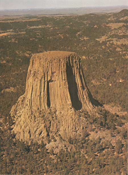
Beyond the limits reached by the ice of the continental glaciers, the Unglaciated Missouri Plateau displays the greatest variety of landforms of any section of the Great Plains. In western Montana, many small mountain masses rise above the general level of the plateau, including the Highwood, Bearpaw, and Little Rocky Mountains near the margin of the glaciated area, and the Judith, Big Snowy, Big Belt, Little Belt, Castle, and Crazy Mountains farther south (fig. 22). Many of these, such as the Crazy, Castle, Judith, and Big Snowy Mountains, are areas uplifted by large, deeply rooted, intrusive igneous bodies called stocks, which have been exposed by subsequent erosion of the arched overlying sedimentary rock layers. Some, such as the Highwood and Bearpaw Mountains, are predominantly piles of lava flows, although in the Bearpaws the related intrusive bodies of igneous rock form a part of the mountains. The Big and Little Belt Mountains were formed by mushroom-shaped intrusive igneous bodies call laccoliths, which have spread out and domed between layers of sedimentary rocks. A number of igneous bodies also intrude the rocks of the Missouri Plateau around the periphery of the Black Hills. Devils Tower, the first feature to be designated a National Monument, is the best known of these igneous rock features (fig. 23).

|
| Figure 22.—The Highwood Mountains seen from the Little Belt Mountains, Mont. Photography by I. J. Witkid, U.S. Geological Survey. |
|
| Figure 23.—Devils Tower National Monument, Wyo. An igneous intrusive body exposed by erosion. Photograph by F. W. Osterwald, U.S. Geological Survey. |
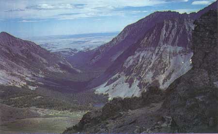
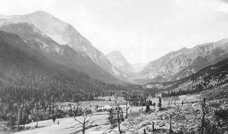
The uplift and volcanism that formed these mountains took place before the streams began to cut downward and segment the Great Plains. The mountains had been greatly dissected before the advent of the Great Ice Age, when alpine glaciers formed on the Castle and the Crazy Mountains and flowed down some of the stream-cut valleys. Alpine glacial features such as cirques, in the high parts of the mountains, and glacially modified U-shaped valleys (fig. 24) are impressive evidence of this glaciation.
|
| Figure 24.—U-shaped, glaciated valley of Big Timber Creek, Crazy Mountains, Mont. Photo courtesy of U.S. Forest Service. |
The Missouri River and its tributaries—the Sun, Smith, Judith, Musselshell, and Yellowstone Rivers in Montana and the Little Missouri River in North Dakota—have cut down into the Missouri Plateau, cut broad upland surfaces at many levels, and established confined valleys with valley floors flanked by terrace remnants of older floodplains. Locally, high buttes that are remnants of former interstream divides rise above the uplands. Large lakes also were formed in most of these tributary valleys because of damming by the continental ice sheets.
West of the Black Hills, in Wyoming, the Tongue River and the Powder River have excavated the Powder River Basin and produced similar features (fig. 25). The east-flowing tributaries of the Missouri River—the Knife, Heart, and Cannonball Rivers in North Dakota and the Grand, Moreau, Belle Fourche, Cheyenne, Bad, and White Rivers in South Dakota—similarly have shaped the landscape.
|
| Figure 25.—View northeast across the Deckers coal mine and the Tongue River in the Powder River Basin, southeastern Montana. Typical terrain of unglaciated Missouri Plateau. Small mesas with cliffed escarpments on capping layer of resistant sandstone, such as those in the foreground, are common. Coal mine is about 1 mile across Photograph by R. B. Taylor, U.S. Geological Survey. |
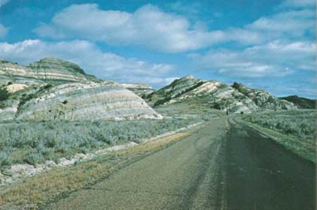
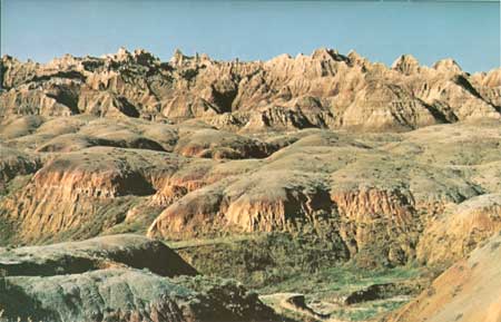
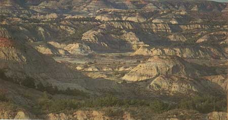
Most of these rivers flow in broad, old valleys, established more than 2 million years ago, before the first advance of the continental ice sheets. Some of these valleys have been widened by recession of the valley walls by badland development. Badlands are formed by the cutting action of rivulets and rills flowing down over a steeply sloping face of soft, fine-grained material composed mainly of clay and silt. The intricate carving by thousands of small streams of water produces the distinctive rounded and gullied terrain we call badlands. Badlands National Park in South Dakota (fig. 26) has been established in the remarkable badlands terrain cut into the White River Group along the north valley wall of the White River, and the South Unit of Theodore Roosevelt National Park is in the colorful badlands of the Little Missouri River, formed on the Fort Union Formation (fig. 27).
|
| Figure 26.—Badlands in Badlands National Park, S. Dak. Photograph by W. H. Raymond, III. U.S. Geological Survey. |
|
| Figure 27.—Badlands of the Little Missouri River in South Unit of Theodore Roosevelt National Park, N. Dak. View looking northwest from near Painted Canyon Overlook along Interstate 94, west of Belfield. Photo courtesy of Bruce Kaye. |
The White River also has cut a steep scarp along its southern wall that is called the Pine Ridge escarpment. This escarpment defines the boundary between the Missouri Plateau and the High Plains here.
The landscape of the Unglaciated Missouri Plateau has been determined largely by the action of streams, but in some areas igneous intrusions and volcanoes have produced small mountain masses that interrupt the plain, and valley glaciers have modified the valleys in some of these mountains.
The Colorado Piedmont
The Colorado Piedmont lies in the eastern foot of the Rockies, (fig. 1) largely between the South Platte River and the Arkansas River. The South Platte on the north and the Arkansas River on the south, after leaving the mountains, have excavated deeply into the Tertiary (65- to 2-million-year-old) sedimentary rock layers of the Great Plains in Colorado and removed great volumes of sediment. At Denver, the South Platte River has cut downward 1,500 to 2,000 feet to its present level. Three well-formed terrace levels flank the river's floodplain, and remnants of a number of well-formed higher land surfaces are preserved between the river and the mountains. Along the western margin of the Colorado Piedmont, the layers of older sedimentary rock have been sharply upturned by the rise of the mountains. The eroded edges of these upturned layers have been eroded differentially, so that the hard sandstone and limestone layers form conspicuous and continuous hogback ridges (fig. 28). North of the South Platte River, near the Wyoming border, a scarp that has been cut on the rocks of the High Plains marks the northern boundary of the Colorado Piedmont. Pawnee Buttes (fig. 29) are two of many butte outliers of the High Plains rocks near that scarp, separated from the High Plains by erosion as is Scotts Bluff, farther north in Nebraska. To the east, about 10 miles northwest of Limon, Colo., Cedar Point forms a west-jutting prow of the High Plains.
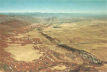
|
| Figure 28.—Hogback ridges along the Front Range west of Denver, Colo. South Platte River emerges from the mountains and cuts through hogbacks in middle distance. Photograph courtesy of Eugene Shearer, Intrasearch, Inc. |

|
| Figure 29.—Pawnee Buttes in northeastern Colorado. Buttes isolated by erosion from High Plains in the background. Ogallala Formation caps top of Buttes. White River Group forms lower part. The top of the highest butte is about 240 feet above the saddle between the two buttes. Photograph by R. D. Miller U.S. Geological Survey. |
The Arkansas River similarly has excavated much of the Tertiary piedmont deposits and cut deeply into the older Cretaceous marine rocks between Canon City and the Kansas border. The upturned layers along the mountain front, marked by hogback ridges and intervening valleys, continue nearly uninterrupted around the south end of the Front Range into the embayment in the mountains at Canon City. Skyline Drive, a scenic drive at Canon City, follows the crest of the Dakota hogback for a short distance and provides a fine panorama of the Canon City embayment.
Extending eastward from the mountain front at Palmer Lake, a high divide separates the drainage of the South Platte River from that of the Arkansas River. The crest of the divide north of Colorado Springs is generally between 7,400 and 7,600 feet in altitude, but Interstate Highway 25 crosses it about 7,350 feet, nearly 1,500 feet higher than Colorado Springs and more than 2,000 feet higher than Denver. From the crest of the divide to north of Castle Rock, resistant Oligocene Castle Rock Conglomerate (which is equivalent to part of the White River Group of the High Plains) is preserved in many places and forms a protective caprock on mesas and buttes. This picturesque part of the Colorado Piedmont looks quite different from the excavated valleys of the South Platte and Arkansas Rivers.
Much of the terrain in the two river valleys has been smoothed by a nearly continuous mantle of windblown sand and silt. Northwesterly winds, which frequently blow with near-hurricane velocities, have whipped fine material from the floodplains of the streams and spread it eastward and southeastward over much of the Colorado Piedmont. Well-formed dunes are not common, but alined gentle ridges of sand and silt and abundant shallow blowout depressions inform us of the windblown origin of this cover.
In the Colorado Piedmont, then, the erosional effects of streams are the most conspicuous features of the landscape, but these are enhanced by the steep tilting of the layered rocks along the western margin as a result of earth movement and modified by the nearly ubiquitous products of wind action, which have softened the landscape with a widespread cover of windblown sand and silt.
Pecos Valley
South of the land of volcanic rocks that is the Raton section, the Pecos River has cut a broad valley from the Sangre de Cristo Mountains, in New Mexico, southward to the Rio Grande, and has removed the piedmont cover of Ogallala Formation and cut deeply into the underlying rocks. The Ogallala Formation capping the High Plains to the east forms a rimrock at the top of the sharp Mescalero escarpment, which is the eastern boundary of the Pecos Valley. (See figure 4.) The western boundary of the Pecos Valley is the eastern base of discontinuous mountain ranges.
The great thickness of Tertiary deposits that formed on the northern Great Plains did not accumulate here, and the Pecos River has cut its valley into the older marine sedimentary rocks. The rocks underlying the surface of much of the Pecos Valley are upper Paleozoic limestones.
The soluble nature of limestone is responsible for some of the most spectacular features of the landscape in the Pecos Valley. For about 10 miles north and 50 miles south of Vaughn, N. Mex., collapsed solution caverns in upper Paleozoic limestones have produced an unusual type of topography called karst. Karst topography is typified by numerous closely spaced sinks or closed depressions, some of which are very deep holes, caused by the collapse of the roof of a cave or solution cavity into the underground void, leaving hills, spines, or hummocks at the top of the intervening walls or ribs separating the depressions.
Although the karst in the vicinity of Vaughn is perhaps the most conspicuous solution phenomenon, sinks and caves are common throughout the Pecos Valley. At Bottomless Lakes State Park east of Roswell, N. Mex., seven lakes occupy large sinkholes caused by the solution of salt and gypsum in underlying rocks.
The most spectacular example of solution of limestone by ground water is Carlsbad Caverns, N. Mex., one of the most beautiful caves in the world. This celebrated solution cavity is preserved in a national park.
The Pecos River along much of its present course flows in a vertical-walled canyon with limestone rims. The Canadian River, flowing eastward from the Sangre de Cristo Mountains, has cut a deep canyon along the northern part of the Pecos Valley section. The sharp rims of the Dakota Sandstone at the Canadian escarpment, north of the Canadian River, form the northern boundary of the Pecos Valley section.
The sharp, northeast-trending broken flexure called the Border Hills that is crossed by U.S. Highway 70-380 about 20 miles west of Roswell is a unique landform of the Pecos Valley. This markedly linear upfolded (anticlinal) structure forms a ridge more than 30 miles long and about 200 feet high.
As in the Colorado Plateau, windblown sand and silt mantle the landscape in many places, but the greatest accumulations are along the base of the Mescalero escarpment at the northeast and southeast corners of the Pecos Valley section.
East of the Pecos River, in the southeast part of the Pecos Valley, the underlying rocks have yielded much oil and potash. Oil fields are common east of Artesia and Carlsbad, and potash is mined east of Carlsbad.
The Pecos and Canadian Rivers and their tributaries have created the general outline of the landscape of the Pecos Valley, but underground solution of limestone by ground water and the collapse of roofs of these cavities have contributed much detail to the surface that characterizes the Pecos Valley today.
Edwards Plateau
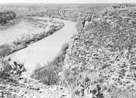
South of the Pecos Valley section, the Pecos River continues its journey to the Rio Grande in a steep-walled canyon cut 400 to 500 feet below the level of a plateau surface of Cretaceous limestone from which little has been stripped except a thin Tertiary cover of Ogallala Formation (fig. 30). To the east, the plateau has been similarly incised by the Devils River and the West Nueces and Nueces Rivers. East of the Nueces to the escarpment formed by the Balcones fault zone, the southern part of the Edwards Plateau has been intricately dissected by the Frio, Sabinal, Medina, Guadalupe, and Pedernales Rivers and their tributary systems. San Antonio and Austin, Tex., are located on the Coastal Plain at the edge of the Balcones fault zone.
|
| Figure 30.—Rio Grade ad the flat-lying limestone layers of the Edwards Plateau downstream from the mouth of the Pecos River Mexico on the left side of picture. Photograph courtesy of National Park Service, Amistad Recreation Area. |
The Pecos River, and to a lesser extent the Devils and Nueces Rivers, particularly in their lower courses, have entrenched themselves deeply in the plateau in remarkable meandering courses of a type that is usually found only in broad, low-lying floodplains. These stream courses reflect the stream environment prior to regional uplift.
Sinkholes pit the relatively undissected limestone plateau surface in the northeast part of the Edwards Plateau, and some underground solution cavities in the limestone are well-known caves, such as the Caverns of Sonora, southwest of Sonora, Tex.
Oil and gas fields are widely developed in the northern part of the Edwards Plateau, but only cattle ranches are found in the bare southern part.
Ancient oceans deposited the limestones that now cap the Edwards Plateau; streams planed off the surface of the flat-lying limestone layers and entrenched themselves in steep-walled valleys; and ground water dissolved the limestone and created the solution cavities that are the caves and sinks of the Edwards Plateau. Water has created this landscape.
Plains Border Section
The Missouri Plateau, the Colorado Piedmont, the Pecos Valley, and the Edwards Plateau all were outlined by streams that flowed from the mountains. On the eastern border of the Great Plains, however, headward cutting by streams that have their source areas in the High Plains has dissected a large area, mainly in Kansas. This Plains Border Section comprises a number of east-trending river valleys—of the Republican, Solomon, Saline, Smoky Hill, Arkansas, Medicine Lodge, Cimarron, and North Canadian Rivers—and interstream divides, most of which are intricately dissected. North of the Arkansas River, the east-flowing Republican, Solomon, Saline, and Smoky Hill Rivers have incised themselves a few hundred feet below the Tertiary High Plains surface and have developed systems of closely spaced tributary draws. The interstream divides are narrow, and the tributary heads nearly meet at the divides. This intricately dissected part of the Plains Border section is called the Smoky Hills. Some isolated buttes of Cretaceous rocks left in the upper valley of the Smoky Hill River are called the Monument Rocks. A large area of rounded boulders exposed by erosion south of the Solomon River, southwest of Minneapolis, Kans., is called "Rock City." These boulders originated as resistant nodules (concretions) within the Cretaceous rocks that contained them.
South of the Arkansas River is a broad, nearly flat upland sometimes referred to as the Great Bend Plains. The Medicine Lodge River has cut headward into the southeastern part of the Great Bend Plains and created a thoroughly dissected topography in Triassic red rocks that is locally called the Red Hills. In a few places, badlands have formed in the Red Hills.
Some large sinks or collapse depressions have formed because of solution of salt and gypsum at depth by ground water. Big and Little Basins, in Clark County in southcentral Kansas, were formed in this way.
Sand dunes have accumulated in places, especially near stream valleys. Dunes are common, for example, along the north side of the North Canadian River.
Oil and gas fields are widely developed in the southeast part of the Plains Border section—in the Smoky Hills, the Great Bend Plains and the Red Hills.
The Plains Border section, like the Missouri Plateau, the Colorado Piedmont, and the Pecos Valley, is primarily a product of stream dissection. The differences in the outstanding landforms of the section are mainly the result of differences in the hardness of the eroded rocks.
| <<< Previous | <<< Contents >>> | Next >>> |
bul/1493/sec4.htm
Last Updated: 28-Dec-2006