
|
Geological Survey Bulletin 1291
The Geologic Story of the Uinta Mountains |
PREFACE
My earliest recollections of the Uinta Mountains reach back almost to the threshold of memory. As a schoolboy I made many hikes to the high ridgelines of the Wasatch Range, east of Salt Lake City, and on such occasions my father often pointed out the snowy peaks of the High Uintas shimmering far off to the east. Mount Timpanogos, near Provo, was a favorite climb in those days, and from its lofty summit all of northern Utah seemed to he spread out at one's feet—all except the Uinta Mountains, which loomed even higher on the horizon. My first actual visit to the Uintas was with an uncle who was an ardent fisherman and the owner of a 1928 Essex coupe. Mirror Lake, 80 miles from Salt Lake City, was at the end of the road and was a fair test, even for an Essex. A day's limit at Mirror Lake was 30 trout, and catching that many wasn't much of a chore. From time to time my uncle and I tried out other lakes in that vicinity, dozens of which were visible from the summit of Bald Mountain. Scout Lake is one, north of Bald Mountain, at Camp Steiner. At an altitude of 10,300 feet above sea level, Steiner is the highest Boy Scout camp in the United States. It was the ultimate objective of every Boy Scout in the Salt Lake Council. No doubt, it still is.
Later, I made the trip to the Uintas many times on my own, in my 1932 Chevrolet roadster, and extended my horizons to the Upper Weber, Haydens Fork of the Bear, the Duchesne, Rock Creek, and Yellowstone Creek. The hike into the lakes was as much fun as the fishing; the cirque walls, the polished rock surfaces, and the erratic boulders all were rather obvious manifestations of glacial erosion, even to an untrained eye.
In 1940 I visited the Uinta Mountains as a student. Under the direction of R. E. Marsell and the late Hyrum Schneider, the University of Utah had set up a geologic field camp on the Duchesne River. Working from there, I gained my first real appreciation of the country's impressive geology.
After a dozen years I returned to the Uintas in the early 1950's, this time in the employ of the U.S. Geological Survey, to map a block of quadrangles along the Green River between Flaming Gorge and Browns Park. I gained a further appreciation of Uinta Mountain geology, and made lasting friendships with many local people.
Over the years I have become acquainted with most of the Uinta Mountains, to some degree, and the following report is drawn mostly from my own notes and memory; but the observations and conclusions of others have been freely utilized. Consciously or unconsciously, I've borrowed from the ideas and published works of J. D. Sears, W. H. Bradley, D. M. Kinney, and other colleagues of the Geological Survey, and from my friends Ernest and Billie Untermann, Codirectors of the Utah Field House of Natural History at Vernal and widely recognized authorities on the geology of the Dinosaur National Monument area. Other authors have been cited where appropriate, but no attempt has been made to exhaust the published literature. Special thanks are extended to artist John R. Stacy, who prepared the illustrations and artwork in this report.
Many statements on the following pages perhaps seem assertive. In a more formal report these statements would be carefully documented. But the geologic literature on the Uinta Mountains reaches back 100 years and is voluminous. Fuller documentation would be distractive in a report of this sort. The few reports cited here contain extensive bibliographies of their own, and the reader is referred to them for more background literature.
The intended scope of the report is fairly broad, but the treatment is not comprehensive. Indeed, in a report this size, only the barest outline can be given on the physical traits of an area as geologically encompassing as the Uinta Mountains.
|
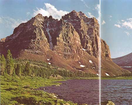
| TURRETED RED CASTLE, altitude 12,825 feet, stands above a glacial lake high on the north flank of the Uinta Mountains. |
"Away to the south, the Uinta Mountains stretch in a long line; high peaks thrust into the sky, and snow-fields glittering like lakes of molten silver; and pine forests in somber green; and rosy clouds playing around the borders of huge, black masses; and heights and clouds, and mountains and snow-fields, and forests and rocklands, are blended into one grand view."
Powell's diary, May 24, 1869
| <<< Previous | <<< Contents >>> | Next >>> |
bul/1291/preface.htm
Last Updated: 18-Jan-2007