
|
Geological Survey Bulletin 1271—E
Pecos National Monument New Mexico: Its Geologic Setting |
ROCKS NEAR THE MONUMENT
The rocks of Glorieta Mesa and Pecos National Monument are all of sedimentary origin; that is, they consist mostly of fragments or grains of older rocks and were deposited by streams, in the oceans, or even in lakes. The fragments that make up the rocks of Glorieta Mesa were deposited 200 to 300 million years ago in nearly horizontal layers; these layers lie in almost the same position today.
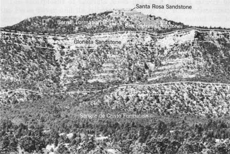
As one can see from the photograph of Glorieta Mesa at Cerro de Escobas (fig. 2), the nearly horizontal layers of rocks can be grouped readily into several units of similar rocks. The six units of rocks that have been separately named by geologists are shown in figure 2. Such units are called formations when the rocks can be separated in this way and traced in the manner shown on the geologic map (p1. 1). A sedimentary formation may be mostly one kind of rock fragment, or alternating layers of at least two kinds of rock fragments either deposited under the same environment or having similar physical characteristics, such as color and thickness of the layers.
|
| Figure 2.—Rock sequence on Glorieta Mesa at Cerro de Escobas; six rock units viewed southwest from Pecos National Monument. |

|
| Plate 1.—Geology and topography of Glorieta Mesa and Pecos National Monument, N. Mex. (click on image for an enlargement in a new window) |
The six units exposed on the escarpment of Glorieta Mesa have been named and mapped throughout New Mexico and one even into south-central Colorado. Each name was formally assigned to a rock unit in a scientific publication by the geologist first describing and mapping the unit. Each name is reserved for its particular unit, and it may not be used again for any other rock unit in the United States. The names of these six formations have been used and recognized in geologic literature for many years. A formation is named usually for a geographic feature near which it was first described or mapped. These formations were named for two mountain ranges, three mesas, and a city. They are all familiar names in New Mexico and without exception show the influence of the Southwest's Spanish heritage on the names of its geographic features.
The youngest formation on Glorieta Mesa is the Santa Rosa Sandstone of Late Triassic age (190-210 million years old; fig. 3) that caps Cerro de Escobas. In this area the upper part of the formation has been removed by recent erosion, and only 50 feet or so remains. At other places in New Mexico the Santa Rosa may reach a thickness of 450 feet. As its name implies, the formation consists of layers of rocks made up mostly of sand grains, that is, sandstone. The sand grains are clean clear quartz cemented together by reddish-brown clay that makes the sandstone a light tan. The Santa Rosa also contains smaller amounts of layered red shale, which consists of extremely small particles of clay and other minerals; the red is due to oxidation, or rusting, of iron-bearing mineral fragments in the shale.

|
| Figure 3.—Generalized geologic sequence of rock units on Glorieta Mesa at Cerro de Escobas near Pecos National Monument. (click on image for an enlargement in a new window) |
The Bernal Formation of Permian, probably Late Permian, age (about 235 million years old) underlies the Santa Rosa Formation. The units are not quite parallel to each other, and thus a relationship known as an unconformity exists between the two units. Rocks of Early Triassic age are missing on Glorieta Mesa, and it is deduced that Early Triassic time was an age when no sediments were deposited in northern New Mexico and when the older rocks of the Bernal Formation were slightly eroded. Here on Glorieta Mesa the Bernal consists of purplish-red sandstone and siltstone. Near the village of Bernal the formation contains some thin beds of gypsum.
Beneath, and older than, the rocks of the Bernal Formation are the gray limestone beds of the San Andres Limestone, also of Permian age. Here there is no unconformity between the two units, for deposition of sediments was continuous and uninterrupted from the San Andres into the Bernal. The limestones of the San Andres are dense and earthy and contain a few sandy layers.
The Glorieta Sandstone is the most conspicuous formation on Glorieta Mesa because of its contrasting light-gray to white color and because it caps the mesa at most places. The Glorieta is also of Permian age, and grades upward into the younger San Andres Limestone without interruption. The clean quartz sand grains of the Glorieta are cemented together so well that the rock is extremely hard and consequently strongly resists the chemical and physical attacks of weathering agents. Throughout its exposures in northern New Mexico, it stands out as a steep cliff face and usually forms the caprock of mesas.
Underlying the Glorieta Sandstone are the bright-red sandstone and siltstone layers of the Yeso Formation of Permian age. Although the change upward from the bright-red sandstone of the Yeso to the light-gray sandstone of the Glorieta is striking, sedimentation was continuous; and changes in thickness of layers and in kinds and sizes of fragments are gradual. The Yeso also contains some thin beds of red shale and a few local beds of limestone. In some areas it also contains beds of gypsum. In the vicinity of Glorieta Mesa, however, conditions were not suitable for the deposition of gypsum.
The Sangre de Cristo Formation underlies the Yeso Formation without a break in sedimentation. The Sangre de Cristo Formation is the oldest formation exposed on Glorieta Mesa and is the oldest Permian formation in the region. The lower part is still older—of Pennsylvanian age. The upper part is about 270 million years old, but the lowermost part may be as old as 300 million years. The upper 100 feet or so of the Sangre de Cristo is very well exposed on the lower face of the Glorieta escarpment. However, in the broad valley formed by the Pecos River and Glorieta Creek, the lower four-fifths of the formation is covered at most places by a mantle of thick red soil derived from the weathering and decomposition of the formation itself. The formation consists of layers of varying thickness of brownish-red and gray conglomerate, buff and red sandstone, red siltstone, red and greenish-gray shale, and gray limestone beds.
Older rocks underlie those of the Sangre de Cristo Formation in the area of Pecos National Monument, but are not at the surface anywhere in the vicinity. These older rocks may be seen along the Pecos River north of the village of Pecos. They consist generally of limestone, shale, sandstone, and conglomerate of Pennsylvanian, Mississippian, and perhaps Devonian age (350-400 million years old) and ancient crystalline rocks of Precambrian age (more than 600 million years old).
| <<< Previous | <<< Contents >>> | Next >>> |
bul/1271-E/sec1.htm
Last Updated: 28-Mar-2006