
|
Geological Survey Bulletin 1221-A
Rockfalls and Avalanches from Little Tahoma Peak on Mount Rainier, Washington |
INTRODUCTION
On December 14, 1963, and probably on several subsequent occasions as well, very large masses of rock fell onto Emmons Glacier from the north side of Little Tahoma Peak on the east flank of Mount Rainier volcano (figs. 1, 2). As the rock masses struck the glacier, they shattered and formed rock avalanches that rushed as much as 4.3 miles downvalley and came to rest less than half a mile from the White River campground in Mount Rainier National Park. As snow melted during the summer of 1964, dark rock debris mantling Emmons Glacier became visible from a visitor center at Yakima Park, and clouds of dust rose almost daily from the rockfall scar. These features attracted much interest from park visitors, many of whom wondered if they were witnessing volcanic eruptions. This article discusses the avalanche deposits, their manner of transport, and what might have caused the rockfalls.
|
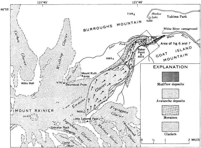
| FIGURE 1.—Map of northeast side of Mount Rainier, showing area covered by avalanches from Little Tahoma Peak. Rectangular area at northeastern end of the deposits is shown in figures 6 and 7. Arrows indicate inferred direction of movement of the avalanches. (click on image for an enlargement in a new window) |
|
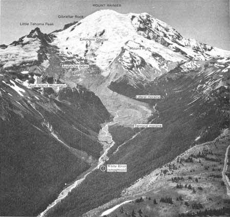
| FIGURE 2.—General view of rockfall-avalanche deposits. Note avalanche debris on Emmons Glacier below Little Tahoma Peak. Wooded ridge in center of lower valley is a terminal moraine of Emmons Glacier formed between about 1700 and the early 1900's. The end of an avalanche tongue downvalley from the terminal moraine is indicated by a dashed line. Aerial photograph by Austin S. Post, U.S. Geological Survey. |
The senior author currently is investigating the surficial geology of Mount Rainier National Park (Crandell and others, 1962; Crandell, 1963; Crandell and Miller, 1964); during the periods July 7-12 and August 19—September 13, 1964, he studied the avalanche deposits and the circumstances that led to their formation. He expresses his appreciation to Ranger Naturalists Arthur Haines, William Kagami, and Duane Nelson of the National Park Service, each of whom accompanied him in the field in July. The junior author, in a recent study of the White River and its flood plain, surveyed 12 profiles across the valley floor just downstream from Emmons Glacier (Fahnestock, 1963). Nine of these profiles were resurveyed in July 1964, with the assistance of David Pedersen, University of Texas, to determine the thickness of the avalanche deposits. Both of the authors wish to acknowledge the interest and cooperation of John A. Rutter, Superintendent of Mount Rainier National Park, and his staff. The Northern Forest Fire Laboratory of the U.S. Forest Service at Missoula, Mont., provided an aircraft equipped with an infrared sensing device; this device was used to examine the north face of Little Tahoma Peak for evidence of volcanic heat. The aircraft was piloted by Eldon Down and the infrared sensing equipment was operated by Robert A. Cook, both of the U.S. Forest Service. Robert M. Moxham of the U.S. Geological Survey interpreted the results of the infrared investigation, and Austin S. Post of the Geological Survey provided aerial photographs he made of the avalanche deposits on August 20, 1964. The authors express their appreciation to J. Hoover Mackin, University of Texas, for discussions regarding the rockfalls and avalanches and for his critical reading of the manuscript.
| <<< Previous | <<< Contents >>> | Next >>> |
bul/1221-a/intro.htm
Last Updated: 28-Mar-2006