
|
Geological Survey Bulletin 104
The Glaciation of the Yellowstone Valley North of the Park |
OUTLINE OF THIS PAPER
The present paper gives a detailed account of the glaciation of the Snowy mountains and of the upper valleys of the Yellowstone, whose deposits show an unusual phase of alpine glaciation.
The evidence thus far gathered shows that a large body of ice, originating in the ice sheets of the Yellowstone National Park, pushed northward, filling the upper valleys of the Yellowstone and extending down that stream 36 miles north of the park boundary.
The high mountainous area east of the Yellowstone river, a large part of which is above 9,000 feet in elevation, was largely mantled by great snow fields and névés, above which the sharper summits projected as spires of rock, giving rise to great glaciers moving outwards down the valleys in all directions, forming the Boulder glacier and many small streams flowing toward the valley of the Stillwater, while other glaciers filled the valleys south and east and became tributary to the Yellowstone glacier. The high country about Haystack peak and Mount Douglas was the center of dispersion for this great ice field.
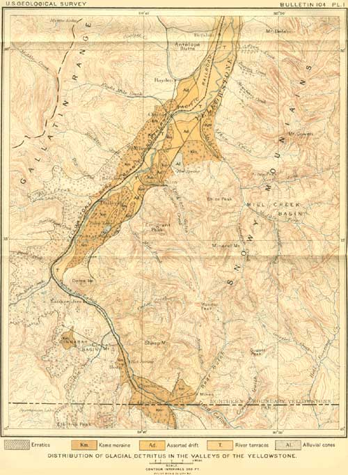
This evidence shows conclusively that there was no general system of confluent glaciers covering all the mountain ranges, but that even the greatest of these glaciers extended down the valleys a comparatively short distance and did not reach the general foothill country, while such considerable mountain masses as the Gallatin range and the high and rugged peaks east of the Lower canyon of the Yellowstone, held only local glaciers which nestled in the cirques about the crest of the range or rarely extended a short distance down the valleys. The area covered by glacial deposits is indicated upon the accompanying map.
|
| PLATE I. DISTRIBUTION OF GLACIAL DETRITUS IN THE VALLEYS OF THE YELLOWSTONE. The terraces and canyons cut across the foot slopes of the Gallatin range deserve special mention as striking examples of erosion performed by streams marginal to the ice sheet. (click on image for a PDF version) |
These glaciers were all of the alpine type and present many resemblances to those now existing in the Mount St. Elias alps. The largest valleys—the Yellowstone and Boulder—were occupied by trunk glaciers, completely filling them and overriding their flanks, and receiving tribute from the lateral valleys where the ice bodies occupying them were large enough to reach the main valley. Throughout the entire field the higher mountain peaks rose above the névé fields, though the high plateaux and broader mountain summits show considerable glacial abrasion and were unquestionably covered by moving ice.
The evidence establishing the former existence of these glaciers consists of the varied forms of glacial sculpturing: Roche moutonnées, canyon-broadening, rock scoring and polishing, and the formation of rock basins; and the various types of glacial deposits, bowlder trains, blocs perche, the transportation of boulders from lower to higher elevations, moraines and kames, and the associated trains of gravel forming the system of river terraces, the formation of benches and terraces upon hillsides, and the cutting of canyons transverse to the mountain slopes and drainages in front of the glacier's termination. The striking contrast between glacial and non-glacial topography is splendidly exhibited in this field.
| <<< Previous | <<< Contents >>> | Next >>> |
bul/104/outline.htm
Last Updated: 14-Jul-2009