|
FORT UNION
Administrative History |

|
CHAPTER 1: A FRONTIER POST
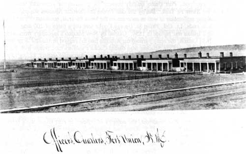
Figure 3. Fort Union was once the largest military post west of the
Mississippi River. Officers' Quarters in 1875.
Courtesy of the
National Archives.
The ruins of Fort Union, New Mexico, stand as a monument to the American frontier experience. The Southwest became a meeting place for various migrants throughout our nation's history as people from all directions moved into the area and built their homes. Constant military conflict and continuous cultural exchange among different ethnic groups has made the region legendary in American folklore. As a military post established to protect travel and settlement from 1851 to 1891, Fort Union witnessed many fascinating events in the course of western American history. A century later, the site of the old fort remains as a vestige of the great American epic.
Fort Union National Monument is located in the Mora Valley in northeastern New Mexico at the westernmost edge of the Great Plains. On its way to join the Mora River, a southward flow of Wolf Creek softly touches the western boundary of the park. In the distance, the Turkey Mountains vigilantly guard its eastern border. Surrounded by a sea of grama grass, the park presents an authentic plains atmosphere even though it is only eight miles from the nearest town, Watrous, twenty-eight miles from Las Vegas, and ninety miles from Santa Fe. Despite its relative isolation, Fort Union is easily accessible from New Mexico Highway 161, which also links the fort to Interstate Highway 25 at Watrous.
At 6,700 feet, Fort Union has an environment conducive to abundant plant and animal life. The Mora Valley climate is mild without great extremes of heat or cold; the average annual temperature at the monument is 49.2 Fahrenheit. July has the highest monthly temperature at 69.7 Fahrenheit, and December the lowest at 33.1 Fahrenheit. Precipitation measures 18.01 inches per year. More than 80% of the annual precipitation comes between May and November. [1] Although it is in a semi-arid zone, the Mora Valley receives enough rainfall to support stands of ponderosa, which thrive on the mountain slopes. Juniper, piñon pine, and blue grama grass grow at lower elevations in the foothills. [2] In addition to the vegetation, more than 50 species of animals such as prairie dogs, rattlesnakes, Canada geese, and burrowing owls have also made their homes in the area. Occasionally, a few bald eagles visit the valley. [3] Lush pasturage, abundant timber, and numerous ponds make the Mora Valley a desirable spot for settlement.
Like most parts of northern New Mexico, the Mora Valley served as a refuge for at least five Indian tribes long before the arrival of Europeans. Navajos, Apaches, Utes, Kiowas, and Comanches either lived, passed through, or fought in the valley, but few written documents and little archeological evidence exists to retell the lives of these nomadic tribes.
By the mid-sixteenth century, life in this region began to change dramatically after European contact. With dreams of finding the seven cities of Golden Quivira, the Spanish Crown was first to encourage exploration of this vast new area. Francisco Vasquez de Coronado nearly reached the Mora Valley during his famous expedition of 1540-1542. After failing to discover gold, the Spaniards began to consider settling New Mexico. In 1598 the Spaniards built their first houses at San Juan near present day Española. Gradually, a chain of settlements emerged along the Rio Grande. Throughout the next 200 years, in fact, Santa Fe attracted many new immigrants, but on the east side of the Sangre de Cristo Mountains, where the Mora Valley lay, there was little settlement until the late 1810s.
Leaving the northern frontier of New Spain unprotected, the Spanish unknowingly allowed Anglo-Americans to encroach into the area from the north. As early as 1802, a Pennsylvanian beaver trapper, James Purcell, adventured into New Mexico from Missouri via Colorado. In 1805, after running out of supplies and pelts, Purcell searched in New Mexico for other means of profit. He decided to mine gold, which he traded to local citizens for goods. Spanish officials in Santa Fe learned of Purcell's activities and ordered him to report for questioning as to his real intention. When he refused to comply with the order, they incarcerated him. He was detained until 1824. [4] Purcell became "the first American who had ever penetrated the immense wilds of Louisiana." Capt. Zebulon Pike of the 6th U.S. Infantry followed in Purcell's footsteps. Under the instruction of the United States a small military team moved west to reconnoiter a potential territory for expansion. Initiating his exploration in the Rocky Mountains in 1806, Pike and his soldiers reached the headwaters of the Rio Grande in Colorado's San Luis Valley by early 1807. Spanish dragoons, however, discovered the Americans and ordered them to Santa Fe, due to their violation of international boundaries. The Spanish finally released him in June 1807, and by 1810 his adventures were published as the Pike Journals. [5]
Early American adventurers like Purcell and Pike threatened the northern frontier of New Spain and created a struggle for dominance in the region. Pike, in particular, with his memoir, mobilized support among the American public. His writings informed Americans of the possibilities for investment. Yankee merchants immediately realized New Mexico's market potential for American goods, after reading that local people had to haul most of their commodities 2,000 miles from Veracruz, Mexico. In the same year that Pike told of his adventures, a revolution broke out in New Spain, which culminated with Mexico's independence in 1821.
Infant Mexico lost no time in welcoming American traders to Santa Fe and abandoning the old Spanish system, which had prohibited American traders in New Spain. Meanwhile American merchants did not hesitate to accept the "invitation" and to inaugurate the Santa Fe trade. With several other enterprising Missourians, William Becknell was one of the first American merchants to send mule pack-trains westward. He crossed 800 miles of prairie and arrived in Santa Fe in the fall of 1821. Governor Facundo Melgares warmly received Becknell and the other Missourians, expressing "a desire that the Americans would keep up an intercourse with that country." [6] The Mexicans were so interested in American trade that it led historian David Weber to write that "Americans were as eager to sell as Mexicans were to buy." [7]
This Santa Fe trade, as well as the Santa Fe Trail, would significantly shape the history of the Southwest. On his second trip to Santa Fe in the spring of 1822, Becknell blazed a short cut by way of the Cimarron River, thereby avoiding the mountainous Raton Pass. The Cimarron Cutoff of the Santa Fe Trail intersected the Mountain Branch in the Mora Valley. [8] In 1825 a military surveying party under George C. Sibley marked out a suitable route from Kansas to New Mexico. By 1830 the Santa Fe Trail, an international highway between Mexico and the U.S., had been established, producing an even greater volume of trade.
Situated at the junction of the two routes of the Santa Fe Trail, the Mora Valley, with both strategic and economic importance, quickly became a focal point of concern for Mexican authorities. The best way to defend an area was to populate it. As early as 1816, a few families of New Spain moved into the western Mora Valley on the eastern slope of the Sangre de Cristo Mountains. Since the dying Spanish regime was unable to protect all the settlers against attack by the Plains Indians, nobody dared to go farther east. Most of the rich valley remained unsettled. [9] However, the young Mexican government showed its anxieties to defend this area. In 1835 Albino Perez, governor of New Mexico, granted 827,621 acres of land including most of the valley to Jose Tapia and 75 others to initiate Mexican policies. [10] More settlers moved into the valley. The future site of Fort Union was at the center of the Mora Grant. In the next ten years, however, the valley sheltered more travelers than settlers since the Santa Fe trade was increasing at a magnificent rate. In dollars, the volume rose from $15,000 in 1822 to $450,000 in 1843. [11] By the eve of the Mexican War, Americans had become commonplace in the Mora Valley.
Soon the number of Americans was overwhelming. When war broke out in 1846 between the United States and Mexico, the Santa Fe Trail was transformed into a military road. Following the old wagon ruts that formed the trail, Brig. Gen. Stephen Watts Kearny led his conquering army swiftly into New Mexico and raised the United States flag without any resistance. On this journey, General Kearny and his troops camped one night near where Fort Union would later stand. [12] Under the Treaty of Guadalupe Hidalgo the United States annexed New Mexico and California in 1848, turning the Santa Fe Trail from an "international highway into a national highway," linking the new territory with the rest of the country. [13]
Alexander Barclay, an American frontiersman born in Britain, was one of the first persons to realize the strategic location of the Mora Valley. An increasing number of Kearny's baggage trains and the government's freight wagons passing through the region meant more services were needed along the road. Barclay, therefore, selected the junction of the Mora and Sapello rivers, about six miles south of where Fort Union was later built, for his trading post. On June 11, 1848, he "laid the first doby of fort and fired cannon...." [14] Although he maintained contact with the military leaders and local communities, Barclay struggled to make his venture a self-sufficient and financially rewarding enterprise. If Indian raiders left his cattle and horses alone and his post profited some what, Barclay hoped that in the future he could sell the fort to the United States government. [15] Like Bent's Fort, a center for Indian trade in Colorado, where he had served as superintendent, Barclay's trading station played an essential role in shaping the Santa Fe Trail.
| <<< Previous | <<< Contents >>> | Next >>> |
foun/adhi/adhi1.htm
Last Updated: 22-Jan-2001