|
Effigy Mounds
Historic Resource Study |

|
CHAPTER EIGHT:
MOVEMENT FOR A PARK
Movement For A Park
A growing national movement for parks surfaced after the Civil War, when a few states created parks to preserve areas of outstanding natural beauty or important historical associations. Battlegrounds, forts, and other places of military importance were primarily targeted. By the 1890s, a broader, national base of public support began to develop. The nation's increasing prosperity meant that more people had time for travel and recreation, and Americans wanted to visit places of scenic beauty. In Iowa, the movement initially took shape under botanist Thomas Macbride of the State University of Iowa, who raised support for parks among the state's conservationists and preservationists. In 1901, Macbride was named the first president of the Iowa Park and Forestry Association, an organization that actively pressed for a state park movement and lobbied for the establishment of a national park in northeast Iowa. [145]
Official support for a park in northeastern Iowa dates from April 6, 1909, when State Representative George H. Schulte of Clayton County addressed the Iowa General Assembly in support of establishing a national site near McGregor. Schulte emphasized the need for "pleasuring grounds" along the Mississippi River for future generations. [146] Schulte's proposal was supported by Ellison Orr, then president of the Iowa Forestry and Conservation Association (IFCA), and by Bohumil Shimek, Louis H. Pammel, and Thomas H. MacBride (professors of natural science and members of the IFCA). Various business leaders and academics also supported the movement, but, interest remained local until just before Word War I. Then, in 1915, Senator William S. Kenyon of Fort Dodge, Iowa, promised to work for a national park and introduced a bill to establish a 1,700 to 2,000-acre park to preserve the mounds. [147]
|
|
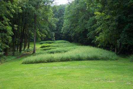
Marching Bear Mound Group From Ground Level. Courtesy of National Park Service |
Representative Gilbert Haugen of Iowa submitted a similar bill, but the Secretary of the Interior decided that action should be halted until a comprehensive study of the area could be conducted. A total of $1,000 was provided to fund the study. In 1917, M.L. Dorr of the National Park Service conducted an inspection of the Upper Mississippi River Valley, but no proposals or actions resulted from this inspection. [148] During this period, the park movement was put on hold while the nation turned its attention to World War I. Despite a slowdown of official attention from Washington, D.C., local park supporters continued to gain force. In 1917, Orr pressed the park issue in a speech at the IFCA (later called the Iowa Park and Forestry Association). He suggested that 10,000 acres along the Mississippi River from McGregor to Sny Magill Creek, the main channel islands, and the bluffs along the Wisconsin side of the river be set aside and preserved. Orr stressed the importance of preserving the balsam firs on the Yellow River bluffs, historic Fort Atkinson, and the mound groups and earthworks along the Mississippi and Upper Iowa rivers. During this same period, Iowan conservationist C. H. McNider wrote an essay titled "What the Mississippi Valley National Park Would Mean to Iowa," that reflected the region's growing awareness of and support for a park. [149]
Between 1917 and 1923, Senator Kenyon and Congressman Haugen introduced a series of bills in Congress for establishment of a Mississippi National Park in northeast Iowa, all of which died in committee. In 1919, Iowa dedicated a handful of sites, and the state soon emerged as a leader in developing parkland. By 1925, Iowa ranked fourth in the nation in number of parks, and by 1931 had established forty state parks. [150]
Another major force for parks in Iowa emerged in 1919. In July of that year, 1,000 people attended a three-day meeting held at McGregor Heights, overlooking McGregor and the Mississippi River, and formed the American School of Wildlife Protection. The school, later renamed the American Institute of Nature Studies, was the first of its kind in the United States. It provided lessons on flora and fauna, often held in the field, and featured evening programs led by distinguished guest speakers who gave presentations on a variety of natural history topics. The wildlife school at McGregor was a significant force in the national park movement in Iowa during the 1920s. By bringing together naturalists, educators, and local citizens, the field school raised public awareness of the region's natural resources and turned McGregor into a center of wildlife conservation activity. [151]
In 1919, a state park report called for designation of state parks at three American Indian mound sites: Toolesboro Mounds near the mouth of the Iowa River in Louisa County, Fish Farm Mounds near Lansing in Allamakee County, and an unnamed mound group near Eddyville in Wapello County. Presumably, the report excluded the effigy mounds along the Mississippi River because conservation and park advocates were optimistic that this area would be included in the proposed Mississippi River National Park. [152]
Plans for a Mississippi Valley park remained on hold in the early 1920s. During this period the U.S. Army Corps of Engineers developed a plan to drain a large wetland between Lansing, Iowa and Lynxville, Wisconsin, called the Winneshiek Bottoms. The plan upset local duck hunters, fishermen, and wildlife enthusiasts. In response, the Izaak Walton League led an effort to preserve the wildlife habitat along the Upper Mississippi River, and other conservation groups joined the battle. [153]
This conservation effort led to passage of the Upper Mississippi River National Wildlife and Fish Refuge Act of 1924, which established a refuge that eventually encompassed more than 200,000 acres of wildlife habitat, including portions of the river adjacent to what would eventually become Effigy Mounds National Monument. The creation of the refuge renewed interest in a national park along the Upper Mississippi, and in 1929 Senator Haugen submitted a new proposal to Congress. The new plan called for a significant increase in acreage from the original plan's 1,700-2,000-acres. Haugen's proposal encompassed the bluffs of four states and 220 miles of river frontage from south of Minneapolis-St. Paul to 45 miles north of Dubuque. It included parts of four counties in Iowa, one in Illinois, eight in Wisconsin, and four in Minnesota. [154]
In 1930, Congress authorized a five-day investigative survey of the park proposal led by Roger Toll, the superintendent of Yellowstone National Park. In his 1932 final report Toll rejected the need for a national park in the area. He reported that the proposed park's "typical rather than extraordinary" scenery was not of national interest. Toll also believed that the proposed site, which included rivers, flood plains, and towns, would be too difficult to administer as a national park because of complicated ownership and management issues. As an alternative, Toll suggested a portion of the remaining Indian mounds along the Mississippi River bluffs be protected as a National Monument. [155] In his report to National Park Service Director Horace M. Albright, Toll wrote:
It is believed that a national park in the valley of the upper Mississippi River is not desirable, but that a national monument, comprising some of the best Indian mounds, would be desirable. I would recommend that a national monument be authorized, whenever suitable land is available for presentation to the United States, for the purpose of protecting and preserving the best examples of prehistoric mounds that are to be found in this region. [156]
Albright agreed with Toll's suggestion, stating, "preservation of the mounds (the effigies), while there is still time to save them, will be of infinite value to posterity. Any mound of this type would add to the completeness of the prehistoric remains that are being protected in our existing national monuments." [157] Local interests quickly abandoned the notion of a national park and began to campaign to secure a national monument for the region. The Board of Conservation in particular, which later merged with the Fish and Game Commission to become the State Conservation Commission, turned its efforts toward setting monument boundaries and acquiring the necessary land. It was during this period that Pike's Peak State Park was established. In the 1930s, the Munn family of New York donated several acres for preservation of Pike's Peak to the U.S. Biological Survey, hoping it would further the cause of establishing a national park along the Upper Mississippi. When plans for the national park fell through, the federal government deeded the land to the state of Iowa. These acres formed the nucleus of what became, in 1937, Pike's Peak State Park. [158]
In 1936, The Iowa Conservation Commission, based on the work of Charles Keyes and Ellison Orr of the Iowa Archeological Survey, submitted a proposal to the National Park Service for creation of a national monument. The report recommended inclusion of the Yellow River Mound Group north of the Yellow River, the Jennings-Leibhardt group consisting of Marching Bears, and selected mounds at Pike's Peak. The report also acknowledged the importance of the Sny Magill and Turkey River mound groups further south. [159] In 1937, National Park Service representatives visited the proposed sites, and later that year dispatched a team to suggest boundaries for the monument. In October 1937, the team's report recommended three mound groups to be included in the proposed monument: Yellow River, Jennings-Liebhardt, and Sny Magill. [160]
Acquisition of lands that ultimately became part of the monument began as early as 1936, with establishment of the Yellow River State Forest. By 1937, the state owned approximately 400 acres in the area. Two years later, through the aid of state Conservation Commissioners Margo Frankel and Louise Parker, the Commission acquired the additional land needed to meet the National Park Service's 1,000-acre requirement for a national monument. The state secured 700 acres of land for the monument, including the Jennings-Liebhardt tract containing the Marching Bear Mound Group. [161]
|
|
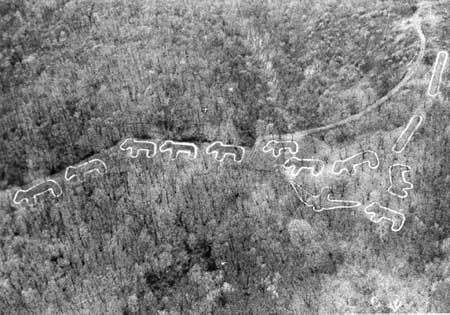
Marching Bear Mound Group. Courtesy of National Park Service |
By 1942, the Commission had secured more than enough land to meet National Park Service requirements, but the outbreak of World War II put the monument project on hold. [162] When the war ended, both the proposed monument and a proposed Mississippi River parkway were revived. The Conservation Commission favored both projects, but the State Legislature and the State Highway Commission hesitated over the parkway proposal because the initial cost to the state was estimated at $625,000, and the highway commission would be responsible for ongoing maintenance. As a result, the parkway idea languished. The monument plan, however, went forward. By 1946, the state of Iowa had transferred all land within the boundaries of the proposed monument to the Department of Interior, and officials had agreed upon the name Effigy Mounds National Monument. That same year, the Advisory Board on National Parks, Historic Sites, Buildings, and Monuments certified the mounds as nationally significant and worthy of protection under the Antiquities Act. [163]
The monument was originally conceived as three separate units: North, South, and Sny Magill. In 1946, NPS Regional Historian Olaf T. Hagen and Iowa Conservation Commission Officer V.W. Flickinger agreed that the Sny Magill unit should be included in the monument to protect the mounds from erosion and nearby logging operations. However conflicts over the U.S. Army Corps of Engineers' insistence on retaining the right to flood Sny Magill and confusion over land ownership resulted in a recommendation to proclaim the Jennings-Liebhardt and Yellow River units as Effigy Mounds National Monument, and to pursue addition of the Sny Magill unit at a later date. In 1947, Howard Baker of the NPS recommended that 1,000 acres be transferred from the state of Iowa to the National Park Service by presidential proclamation. During this period, officials decided that the monument headquarters would be established at Yellow River, near the proposed South Unit, and in 1947, the state of Iowa acquired 68 acres in this area. After boundaries were established and the monument plans finalized in 1949, the NPS accepted title to the 1,000 acres in Clayton and Allamakee counties for establishment of Effigy Mounds National Monument. [164]
Creating A National Monument
|
|
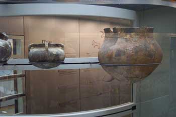
Prehistoric Artifacts on Display at Visitor Center. Courtesy of National Park Service |
On October 25, 1949, President Harry Truman signed a proclamation establishing Effigy Mounds National Monument. The monument consisted of two areas: the Jennings-Liebhardt tract (South Unit) and the Yellow River Unit (North Unit). As discussed above, Sny Magill was not initially included in the monument due to land title problems. This site, however, was federally owned and thereby afforded a degree of protection. Following the presidential proclamation, the NPS assumed management of an additional 204 acres, transferred by the state of Iowa to the federal government in 1951-1952. In 1955, the Des Moines Garden Club donated an additional 40 acres, containing Founder's Pond, to the monument. [165]
In 1956, the NPS began implementation of Mission 66, a ten-year developmental program designed to address park infrastructure needs. The concept for Mission 66 emerged in the early 1950s, when increased visitation highlighted the neglected condition of many parks, their resources, and visitor services. Mission 66 construction included roads, camping and picnic areas, sanitary facilities, housing, and visitor centers. Museum exhibits, informational pamphlets, and audio-visual programs also were developed. Mission 66 greatly increased the number of personnel working at the parks. [166] At Effigy Mounds National Monument, several Mission 66 projects were undertaken. In 1959, workers installed water and sewer systems, rebuilt the entrance road and parking lot, and began constructing residences. These housing units were based on designs used at Glacier National Park. The following year, the monument's visitor center was completed using Mission 66 funds, and the former farmhouse that had served as a residence was torn down, and a shop and two residences constructed on the site. [167]
Changes to the monument continued throughout the 1960s. In 1961, the 100-acre Ferguson tract was added to the monument. A new trail, known today as Fire Point Loop Trail, was constructed from the visitor center to the top of the ridge. In 1962, the South Unit opened, and the new visitor center began full operations. That same year, the U.S. Army Corps of Engineers transferred the Sny Magill property to the NPS, doubling the number of mounds within the monument. With the addition of Sny Magill, the monument encompassed a total of 1,476 acres and contained 191 known prehistoric Indian mounds, including 31 bird and bear effigies. In 1986, the National Park Service began preparing a general management plan for Effigy Mounds National Monument, and conducted a major study of the Sny Magill unit. In 1999, the Iowa Natural Heritage Foundation purchased an additional 1,045 acres, known as the Kistler-Ferguson Tract. The tract, with its wetlands, forests, and bluffs along the Yellow River, contained two well-preserved bear mounds. [168] On December 15, 2000, the Kistler-Ferguson property (known as the Heritage Addition) was transferred to the NPS, increasing the total size of the monument by sixty percent. Although the Heritage Addition has not been systematically surveyed, thirteen archeological sites have been identified within the new acreage, including two well-preserved bear effigies, several linear mounds, and Indian habitation sites. [169]
| <<< Previous | <<< Contents >>> | Next >>> |
efmo/hrs/hrs8.htm
Last Updated: 08-Oct-2003