|
EBEY'S LANDING
An Unbroken Historical Record: Ebey's Landing National Historical Reserve Administrative History |

|
Chapter Two:
DESCRIPTION OF THE RESOURCE
The following is a summary of the physical, economic and demographic characteristics of Central Whidbey Island, in which Ebey's Landing National Historical Reserve is located.
Geography of Whidbey Island
Whidbey Island is in an area that once lay under 3,000 feet of ice. Thirteen thousand years ago, receding glaciers gouged out the waterways and shaped the features of Puget Sound. Glacial moraine formed Whidbey Island, and like most Puget Sound landforms, it ranges no higher than 500 feet in elevation. The island varies from one to ten miles in width and its length extends nearly 40 miles in a north-south direction. Whidbey is the largest island in the Sound; in fact, after New York's Long Island was officially declared a peninsula in 1985, Whidbey Island could claim to be the longest and largest island in the lower 48 states. [1]
|
| Map 3. Topography of Whidbey Island. From Land Use, Environment, and Social Change: The Shaping of Island County, Washington, by Richard White, copyright 1980, University of Washington Press. Reprinted with permission of the University of Washington Press. |
Situated in the northern Puget Sound, 27 miles north of Seattle and 50 miles south of the Canadian border, Whidbey Island stretches from 48 degrees to 48 30' northern latitude. It has long summer days--sixteen hours of daylight at summer solstice--and long winter nights. As in the rest of the Puget Sound, the marine environment provides one of the most uniform temperatures in the country. Wet and dry seasons are moderate but distinct, with cool, dry summers, and foggy, damp winters.[2]
Two mountain ranges also moderate local conditions. To the east of the Sound, the Cascade Range deflects continental winds. Roughly one-hundred miles to the west is Washington's Pacific coast, where the continental United States receives its highest rainfall. Because the Olympic Mountains stand between the coast and Whidbey Island, they catch much of the rain that pounds the coast all winter. Whidbey Island still receives abundant, if gentler, winter precipitation, which occasionally turns to snow. The northern half of Whidbey Island is well situated in the Olympic rainshadow, and averages less than 20 inches annually, while the southern half of the island receives 30 inches. The only streams are in the south, and these are small and intermittent. Water is limited, particularly in the north.[3]
Prairie constitutes approximately five percent of Whidbey Island, and provides some of the richest farmland in the state. Once heavily forested with gigantic Douglas fir, western hemlock and red cedar, the island is still fifty-eight percent forest, although little or no old growth remains. The southern portion of Whidbey Island is hilly, and contains the highest plateaus on the island. The north is mostly prairie, coastal peat bog, and forested lowland; here lie agricultural areas that have sometimes set world records for wheat production. Garry oak grows near Oak Harbor, while red alder, maple, ash and willow grow in wet areas and at shoreline. Other common trees and shrubs on the island include rhododendron (confined largely to a small area east of Coupeville), salal, cascara, madrona, Oregon grape, blackberries, huckleberries, snowberries, brackenfern (in open areas) and swordfern (in shady places). Nettles grow on disturbed sites; sedges, cattails, skunk cabbage, sphagnum moss and other species are common in fresh water bogs.[4]
Wolves and bears once lived on the Whidbey Island. It is still home to at least 38 species of mammals, including weasels, red-tailed foxes, raccoons and black-tailed deer. Migrating waterfowl use the shoreline and wetlands for stopovers and for nesting and breeding.
Local Demographics and Economy
The majority of Washington's population lives in the 75-mile corridor between Tacoma and Everett to the east of Whidbey Island. Most of the state's industry is concentrated in this area, the most notable in the Puget Sound economy being computer software, especially Microsoft, and the Boeing Corporation, which has its headquarters in Seattle and plants spread between Everett and Seattle. A strong component of the economy of western Washington is the processing of raw resources such as fish, timber, and metals, ad the northwestern counties yield some of the highest agricultural and dairy production in the nation. Four major oil refineries have been built in the Puget Sound area since 1960; these receive crude oil from the Alaskan North Slope as well as Canada and other foreign fields. Visitors and investors from British Columbia also play a important role in the local economy. Canadians cross the border for shopping and recreation, and private ad corporate investors hold large tracts of commercial and recreational real estate.[5]
With its immediate neighbor Camano Island and three tiny, nearly uninhabited islands, Ben Ure, Strawberry and Smith, Whidbey Island is part of Island County, one of the state's smallest counties. Col. Isaac N. Ebey, its first permanent white settler, helped organize Island County in 1853. By 1992, the population of Island County was 64,800, relatively dense for a county of its size. While Camano Island is the most residentially developed of the five islands, the area in the county with the densest population is Oak Harbor, on north Whidbey Island. The largest factor in the economy is the government, particularly the U. S. Naval Air Station in Oak Harbor, but tourism and recreation services are also key. Agriculture, fishing, and lumbering, once vital, have become minor economic activities. For planning purposes the county has divided Whidbey Island into North, Central, and South Whidbey.[6]
Description of the Reserve
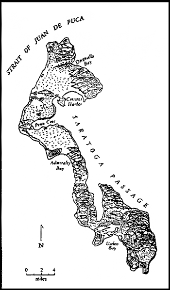
Ebey's Landing National Historical Reserve spans a narrow bend in northern central Whidbey Island, a section where one is never more than two and a half miles from shoreline. The reserve totals 17,400 acres; 13,470 land and the 4,330 acres of Penn Cove. Approximately 42% of the land in the reserve is classified as "agricultural/open space" by Island County, most of which is contained within three prairies (or former prairies), Smith, Crockett, and Ebey's. Nearly 36% is classified woodlands, 11.4% residential, nearly 5% wetland, and 1% urban/commercial. About 90% of the reserve is privately owned. Only 12% at most will be directly affected by the federal designation through such protections as scenic easements; the remaining lands rely on local zoning for protection.[7] The western boundary of the reserve is an eight-mile stretch of beach on Admiralty Inlet. Spread out along the coast from north to south are Fort Ebey State Park, Perego's Lake, Ebey's Landing, Fort Casey State Park, and Keystone Spit. Much of the coastal strip is edged by steep bluffs and is impassible during high tides. Fort Ebey, to the north of Ebey's Prairie, was created in World War II for coastal defense. Its campground is well hidden among the salal bushes ad is a short walk to the bluffs overlooking the inlet. East of Fort Ebey are the West Woodlands, underlain in spots by glacial kettles, depressions created by ice pockets left behind by melting glaciers. One such kettle forms Lake Pondilla, which lies within Fort Ebey State Park.
The reserve stretches about six miles on either side of Coupeville. Its centerpiece, Ebey's Prairie, is the largest open space in the reserve and contains the most productive agricultural land. It is a broad, trough-shaped lowland which spreads obliquely to the northeast from the western coast of central Whidbey Island. The prairie is the site of a former glacial lake; today it contains a mosaic of historic farms and features some of the oldest buildings in the state. The cropland extends nearly to the beach, to a low point called Ebey's Landing. The northwestern and southeastern edges of the prairie are wooded uplands. The view from the uplands and the bluffs at water's edge is especially fine: Admiralty Inlet, Puget Sound, the San Juan Islands, the Olympic Peninsula, and the Cascade Range provide a spectacular backdrop. Fort Casey, south of Ebey's Prairie, preserves a coastal defense installation built in the 1890s and activated in 1900. Within the fort's historic boundaries, bunt not part of the state park, is Seattle Pacific University's Camp Casey, a private Christian facility featuring summer soccer camps and an outdoor education center. The Fort Casey Uplands, on the route between Keystone Spit and Coupeville, provide views of Fort Casey State Park and the Strait of Juan de Fuca.
South of Fort Casey, the coastline curves sharply to the east. Here lies Keystone Spit, a narrow sand and gravel bar separating Admiralty Bay from Crockett Lake. State Route 20 bisects the spit, and a ferry travels regularly between the spit and Port Townsend on the Olympic Peninsula. Most of the spit is preserved as open space and is now owned by the state, but several private homes, a restaurant, and park facilities stand on the west end near the ferry terminal. Crockett Lake to the north of Keystone Spit is brackish, an important stopover and feeding ground for shore birds and migrating water fowl. The Washington State Parks and Recreation Commission and Seattle Pacific University own most of the lake. Public access to the lake is confined to Route 20 and secondary county roads. Except for the university's occasional canoe classes, no boating occurs on the lake; it is primarily used by bird-watchers. Open meadows, farmland, and wooded ridges lie to the north of the lake and wetlands.
Travelling north from Keystone Spit toward Penn Cove, one passes through a rolling landscape of historic farms and woodlots. At the extreme eastern end of the reserve is Smith Prairie, the first major open space visible to travellers entering from the south. It is dominated by the U. S. Navy's practice landing strip, called the outlying field (OLF). Toward Coupeville, picnickers and campers can enjoy the quiet woods of Rhododendron State Park, DNR land administered by the county.
Cutting into the central portion of Whidbey Island is Penn Cove, a U-shaped bay famous for its shellfish. Coupeville, on the southern shore, is the commercial, governmental, and social center of the reserve. Historically, Coupeville served the farming community as county seat, town center and shipping point. Today it retains the county seat, but only pleasure boats and an occasional float plane land at Coupeville's dock. Outside of local services and governmental offices, tourism is the town's principal economic development. The town is part of one of the largest historic districts in the country, the twenty-two-square-mile Central Whidbey Island Historic District, which has nearly one hundred structures currently listed in the National Register of Historic Places (the establishment of this district is discussed in Chapter Three). The town harbors a variety of picturesque seaside homes and shops. At the west end of Front Street is the county historical society and museum, where the reserve trust board rents office space and maintains a small exhibit. Across the street, an interpretive kiosk stands ant the entrance to the long wharf. Here visitors can watch seagulls picking through the clambeds and enjoy the scenery of the cove.
At the west end of Penn Cove is Grasser's Hill, an open grassy slope at the head of the Cove. Grasser's Lagoon, which lies at the foot of the hill, is shallow and rimmed with mud flats. Few structures are visible on the hill, and this enhances the spacious appearance of the area. On the water's northern edge, the San de Fuca Uplands combine residential, farm, and pasture lands. Traveling eastward, Monroe's Landing, the site of a former Indian village, provides one of the few wading or swimming beaches on the cove. It now contains a small parking lot for fishermen and an interpretive sign. Finally, Blower's Bluff, green pastureland at the mouth of Penn Cove, completes the patchwork of homes, historic houses, and broad green spaces. Together, these areas are a graceful backdrop to Coupeville and provide a pleasant tour of the cove.[8]
Historical Resources
The boundaries of the reserve coincide with the Central Whidbey Island Historic District, established in 1973, which in turn follows the original Donation Land Claim Act settlement patterns described in Chapter Three. This district does not precisely match the county's central Whidbey Island planning unit. Many of the original frame houses and false-front shops of Coupeville still stand; ninety-one buildings have been added officially to the National Register of Historic Places, with additional listings pending. The historic district contains a variety of houses and farm buildings, and structures such as wharves, docks, blockhouses, the military installation at Fort Casey (which has the only two remaining large calibre disappearing guns in America), and the nearby lighthouse, erected in 1905. The district displays a colorful variety of building styles, from simple vernacular designs to Queen Anne, Italianate, and Second Empire. Victorian homes of the 1890s mix with saltbox houses and other New England-style houses reproduced by the "Bostons" or ship captains who settled Coupeville in the 1850s. Street and place names commemorate many of the first white settlers.[9]
| <<< Previous | <<< Contents>>> | Next >>> |
adhi/chap2.htm
Last Updated: 27-May-2000