|
DELAWARE WATER GAP
Historic Resource Study Slateford Farm |

|
HISTORICAL BASE MAPS
|
|
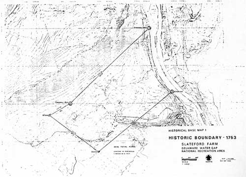
Historical Base Map 1 — Historic Boundary - 1753 (click on image for a PDF version) |
|
|
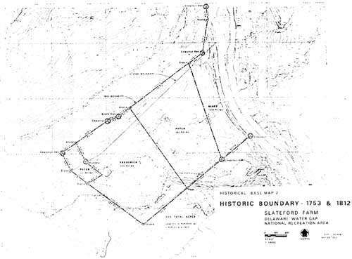
Historical Base Map 2 — Historic Boundary - 1753 & 1812 (click on image for a PDF version) |
|
|
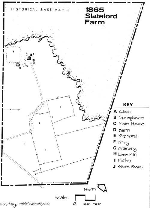
Historical Base Map 3 — 1865 Slateford Farm (click on image for a PDF version) |
ANNOTATIONS FOR HISTORICAL BASE MAP 3
This map represents the Samuel and Elizabeth Pipher farm prior to their selling the property to the New York and Delaware River Slate Company. Extensive research in local and county records and documents, and secondary sources has not provided adequate data to make a definitive determination about the number, exact locations (in most instances), or precise dimensions or appearances of several structures and other cultural resources at the Pipher farm during that family's three generations of ownership from 1790 to 1868. The location of the main house, springhouse and cabin are known as they are extant. The barn foundations are extant, but the appearance of the barn is not known. A granary was mentioned in the 1868 deed of sale, but its exact location is not known. An historic privy is assumed to be located somewhere near the main house, but its exact location is not known. An orchard was located on the farm, but its exact location and total acreage is not known. Extant ruins of a lime kiln mark that structure's precise location. The exact configuration of the historic fields is not known, but the historic stone rows delineate partial farm boundaries and fields. The entrance road to the central farm core is believed to be historic, but its precise configuration is not known.
|
|
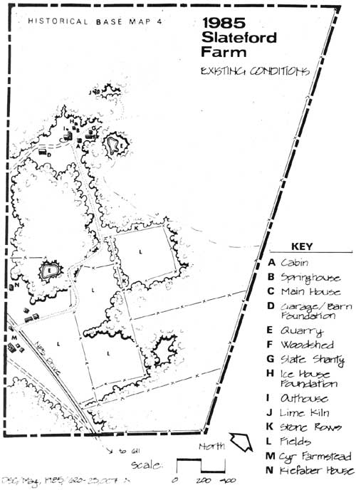
Historical Base Map 4 — 1985 Slateford Farm (click on image for a PDF version) |
ANNOTATIONS FOR HISTORICAL BASE MAP 4
A. Cabin — built c. 1800-1810 by Samuel Pipher. This structure was renovated in 1873, altered by Charles M. Munsch and stabilized by the National Park Service in 1979. Much of the work performed in 1979 reversed Munsch's alterations. The work included: roof repairs, repointing of stone chimney and foundation walls, rebuilding of brick chimney, removal of imitation log siding, repair of entrance hood, replacement of sills, studs, doors and windows, removal of concrete bathroom and entrance slabs, and drainage grading.
B. Springhouse — This stone structure was built in 1827 by Peter Pipher. The springhouse underwent structural change when concrete was poured on the floors and milk can troughs, and the upper roof structure was replaced.
C. Main House — The main farmhouse was built in 1833 by Peter Pipher. A slate roof, direct access to the northwest bedroom, and an outside door to the northwest first floor room were added in 1873. Buff-colored cement stucco was added by Charles M. Munsch. Portions of the front and side porch were screened in 1969.
D. Old Barn Site — Reference to the barn was made in 1868 when Samuel and Elizabeth Pipher sold the farm to the New York and Delaware River Slate Company. Reference was also made to a granary being somewhere on the property. A concrete roof was placed over the remnant stone walls by Charles M. Munsch, who then used the structure as a garage. He used salvaged iron rails, possibly from a nearby quarry, to support the concrete roof.
E. Quarry — The New York and Delaware River Slate Company opened and operated this quarry near the core farmstead from 1868-1873. Subsequent farm owner John A. Morison paid taxes on the quarry until 1879. A much smaller quarry/pond is also on the property. It is shallowly flooded over a sediment fill, and was dammed for domestic water supply. This excavation's history is not known.
F. Woodshed — This structure was built in the late nineteenth century, possibly by John A. Morison.
G. Slate Shanty — Omega G. East, chief of interpretation at Delaware Water Gap National Recreation Area, purchased the shanty in Bangor, Pennsylvania and placed it on the property in the early 1970s.
H. Ice House — Only the foundations exist for this wood frame structure, built by Charles M. Munsch sometime after 1924. The ice house had a gable roof and the walls were covered with horizontal slabbing with vertical slabs in each corner and in the gable ends.
I. Outhouse — This structure was brought onto the property by Omega East sometime in the 1970s. The location of the historic outhouse is not known, but in 1970 Mary Pitenger remembered an outhouse being located between the woodhouse and springhouse.
J. Lime Kiln — Remnants of a stone lime kiln are located in the woods behind the main house. It is probable that the kiln dates to the Pipher family occupancy, and may have been used as late as the Munsch ownership.
K. Stone Rows — Extensive stone pile rows mark partial boundaries of the Peter Pipher farm, and probably date to that period. The rows also delineate boundaries of fields.
L. Fields — The exact location of all the fields utilized by the Piphers and subsequent Slateford Farm owners is not known, but the stone rows do mark several boundaries. Photographs taken during the Munsch occupancy of the farm reveal that many of these fields located between the main farm house and the Cyr farmstead were open and farmed.
M. Cyr Farmstead — Charles M. Munsch built the farmhouse, which became the home of the Louis and Lottie Cyr family who tenant-farmed Slateford Farm. The farmstead includes the main house, storage shed, chicken coops, small frame storage building, corn cribs, barn and garage. The Cyr house has no architectural significance.
N. Kiefaber House — This house was built c. 1925 by Fred W. Kiefaber. There are no outbuildings and the house has no architectural or historical significance.
Other features extant or no longer extant on the Slateford Farm site:
1. Entrance Road to the farm core area — This gravel road, approaching the main farm house from the southeast, may be the historic entrance to the farm. The Piphers may have used it to reach a wagon road located next to the Delaware River. In summer 1985 NPS archeologists found probable nineteenth century terracing and a road bed with an intact stone culvert, located downhill of the barn foundations.
2. Double Mining Cart and Rails — This iron and wood cart was brought onto the property by National Park Service staff, as were the iron rails. The cart is rapidly deteriorating, being openly exposed to the weather. The rails are strewn along a path to the north of the slate shanty.
3. Garden — In 1970 Mary Pittenger mentioned a garden being located in the yard to the southwest of the main house, between the house and the barn.
4. Corral — This structure, located in front of the main house and extending to the garage, was built by the Youth Conservation Corps in 1974-1975.
5. National Park Service Road — This road was built in 1970.
6. Tower Foundations — Four footings of concrete are all that remain of this structure, which perhaps was a radio tower.
7. Woodhouse — The location of this woodhouse, mentioned by Mary Pittenger in 1970 and presumed a different structure from the extant woodshed, is not known. Pittenger stated there used to be a woodshed and wood pile to the right, or northeast, of the main house.
8. Chicken House — The existence of a chicken house was mentioned by Mary Pittenger in 1970. It stood between the woodhouse and the spring house.
9. Barn Outhouse — This outhouse was mentioned in Mary Pittenger's 1970 interview. Its exact location is not known.
10. Slate Walks — These walks were mentioned in Mary Pittenger's 1970 interview. She remembered a slate walk leading from the main house yard to the barn. Other walks led to the spring house, cabin and woodhouse. Remnants of a slate walk are located behind the main house.
11. Tennis Courts — Charles M. Munsch built tennis courts behind the main house. Their exact location is not known and no visible remnants exist.
12. Main House Yard Fence — This fence was mentioned by Mary Pittenger in an 1970 interview. No remnants are visible.
l3. Swimming Pool — In summer 1985 NPS archeologists discovered a stone foundation east of the barn foundations which may be a remnant of a reputed Charles M. Munsch swimming pool.
14 Apple Orchard — An apple orchard was mentioned in Samuel Pipher's 1812 will, but its location is not known. Mary Pittenger remembered an apple orchard being located by the garden towards the mountain.
15. Slate and Stone Benches — Two benches are located underneath the tree next to the main house. Their origin is not known.
|
|
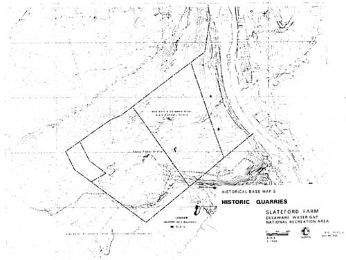
Historical Base Map 5 — Historic Quarries (click on image for a PDF version) |
| <<< Previous | <<< Contents>>> | Next >>> |
dewa/slateford_farm/maps.htm
Last Updated: 31-Dec-2009