|
CRATERS OF THE MOON
Administrative History |

|
Chapter 6:
RESOURCE MANAGEMENT
OVERVIEW OF NPS TRENDS IN RESOURCE MANAGEMENT
Resource management in the National Park Service has followed several distinct trends. For the agency's first several decades, Directors Stephen T. Mather and Horace M. Albright promoted the park system for its scenic beauty. The thrusts of their policies were protection-oriented and reflected efforts to accommodate the public and develop a political constituency. During this period, manipulation of wildlife constituted the most common management policy. Although recommendations by Park Service wildlife biologist George M. Wright in the early 1930s began to alter the agency's practice of predator control, ecological management was still viewed as conflicting with development needs. The development of sound scientific resource management policies lay dormant following Wright's death in 1936 and the nation's entrance into World War II. During the postwar years, the boom in Park System visitation and the Mission 66 program, begun in the mid-1950s, brought the poor conditions of the parks into sharp focus. Predating the environmental polices of the National Environmental Policy Act, Mission 66 emphasized new facilities with little consideration for their effects on the environment. To some observers, the program appeared to benefit only the visitor through the expansion of roads and the construction of new facilities, and ignore resource management issues and scientific research. [1] To others, it reflected great strides in resource management, particularly where, for example, some visitor accommodations were phased out of environmentally sensitive areas, and the areas allowed to return to their natural states. [2]
In the 1960s, resource management policies began to exhibit a shift from the Mission 66 emphasis on visitor accommodations to environmental protection. Credited with having the greatest effect on park management was the 1963 publication by a team of scientists titled Wildlife Management in the National Parks. Commonly referred to as the Leopold Report, the study stressed that the agency should consider the composite whole of park ecosystems and their processes in management decisions, with a primary qualification being the preservation of original conditions. A highlight of the environmental movement was the 1964 passage of the Wilderness Act, bringing to a close ten years of lobbying by conservation groups, and initiating studies and designations for wilderness within the National Park System.
The environmental movement was further strengthened in the 1960s and 1970s by the support of the general public, which was becoming increasingly aware of and sensitive to environmental issues, including human impacts and the importance of ecosystems. As one historian of the movement has observed, the "major national parks came to be valued both as important parts of the global ecosystem and as unique, distinct areas where nature-altering human activities must not be allowed to take place." [3] In other words, environmental awareness was assuming a global perspective. Parks were not only scenic wonders but also environmental barometers, capable of interpreting the state of our environment through scientific research. The 1978 Redwood Act reaffirmed the NPS responsibility for preservation and committed it to this new understanding.
Trends in the 1980s continued to reflect this emphasis on natural processes, with a greater emphasis on a holistic management approach. Other emphases concentrated on ongoing resource threats, especially from external pressures, such as residential developments, and commercial and industrial ventures. The 1980 "State of the Parks" report recommended new policies for baseline resource inventories and monitoring in order to understand and mitigate resource deterioration. Today, Park Service resource management thrusts continue to focus on scientific research and emphasize the preservation of park processes, looking beyond the park's artificial political boundaries to the greater ecosystem that determines whether the park will be preserved. [4]
|
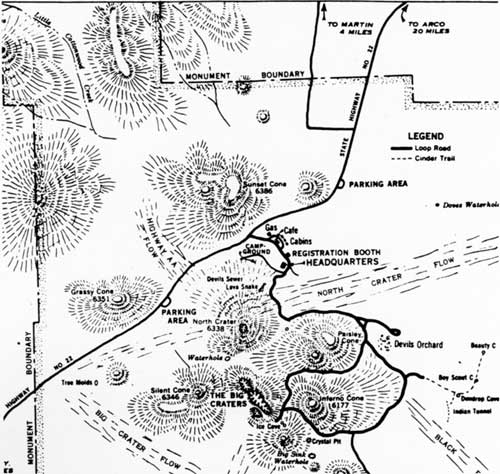
| The monument's principal features as presented in a tourist map from the late 1930s, one of the few maps identifying the "Devils Sewer" and "lava snake" just south of the campground. |
RESOURCE MANAGEMENT AT CRATERS OF THE MOON
At Craters of the Moon, resource management serves as a catchall phrase for management in general, for the protection of resources entails identifying threats and solutions. Generally speaking, resource management at the monument mirrors the phases of resource management that the park system experienced overall. Early resource management was that in name only, becoming more refined as the monument's administration evolved. Like most park units, the monument was virtually shut down during World War II, with resource management abiding by a "hold-the-fort" philosophy. The "formal" or organized era of resource management at Craters of the Moon commenced at mid-century with the Mission 66 program. Armed with a new physical plant and sufficient staffing in a time of escalating visitation and resource impacts, monument superintendents began producing resource management plans for the first time. In doing so, they developed the monument's resource management program.
MANAGEMENT PHILOSOPHY
Central to any program was a resource management philosophy; the monument's stems from its enabling legislation, the National Park Service's 1916 Organic Act, as well as other relevant federal laws and NPS policies and regulations. As outlined in President Calvin Coolidge's 1924 proclamation establishing the area, monument administrators have endeavored to manage the area's resources for their unusual scientific and educational values and general interest. The one statement that articulates best the monument's current management philosophy dates to the 1966 resource management plan, but is restated in similar form in the most recent plan:
It is important to recognize the deceptively fragile characteristics of the volcanic structures and their associated natural features found within the monument. Careful management of human use of the area is necessary to prevent permanent and irreversible damage to the resources and to ensure that the natural state of the monument will be perpetuated for future generations. [5]
The area's management philosophy was also influenced by its classification as a natural monument from 1964 to 1977. In this respect, Craters of the Moon has been managed to protect its primary feature, the basaltic volcanism of the Great Rift. Other natural resources recognized by management are the biological phenomena of the contorted landscape. By comparison, cultural resources play a minor role in the monument's resource management program. Yet the experiences of early and contemporary humans within and near the monument expands our understanding of the volcanic zone. Indians, explorers, and pioneers in the region during the 19th and early 20th centuries offer administrators physical, written and visual documentation of the area's resources. Interpretive programs present both natural and cultural aspects of the monument, and help protect the monument by educating the public in the two disciplines. A comprehensive research program concentrating upon the scientific and cultural resources of the monument has linked these diverse areas of resource management. Whether in natural or cultural history, these types of investigations allow managers to gain a broader context for the monument's resources, and achieve an understanding of changes to the area over time. Providing visitors with appropriate recreational experiences, while not adversely impacting the monument's resources, forms another management objective. Attention to all of these matters goes toward fulfilling the area's mission.
Overall, management of the monument's resources addresses issues relevant to early administrations, specifically in the categories of geology, wildlife, and vegetation. Collection, vandalism, and other forms of human erosion persistently impact the area's volcanic features. Similarly, illegal hunting of mule deer has been the most common threat to the monument's wildlife, as has been trespass grazing to the area's vegetation. This trend reflects a strong historical continuity in management. It also reflects the fact that past management was aware of only the most obvious threats. Advances in resource management demonstrate a growing awareness of more subtle threats, which, like changes in air quality, are difficult to detect, yet the impact of which could be profound.
MANAGEMENT ZONES
Resource management at Craters of the Moon falls into two general management zones, natural and developed. Most telling of the monument's zoning is that of the area's entire 53,545 acres 43,243 are designated wilderness. That leaves 10,302 acres to comprise the core of the monument's administration and use; the landscape includes the most dramatic features along the Great Rift, encompasses the foothills and flanks of the Pioneer Mountains to the northwest as well as park development, visitor services and facilities, and the major interpretive motor route through the monument. [6]
Since most of the monument lies within a designated wilderness, the majority of visitor activity and resource damage takes place in the frontcountry. The harsh and remote environment of the wilderness area attracts few visitors. The northern unit, considered a backcountry, but open to day hiking and biking, sees a small amount of activity--its use regulated to protect the monument's water supply and deer herd during hunting season. Moreover, the frontcountry is the region where the monument's outstanding natural features are located, easily reached by the scenic loop drive and its adjoining pullouts and trails, thus concentrating resource impairments. However, this neither minimizes the potential for nor exempts other sites from internal or external threats.
PROGRAM DEVELOPMENT
The formation of a resource management program can be seen, for the most part, in resource management planning and through the monument's various phases of administration, providing further context for specific issues discussed later.
THE EARLY YEARS AND THE SELF-MANAGING MONUMENT
Formal planning for a resource management program did not occur until Mission 66, yet the theme that the monument was self-sustaining pervades the development of the monument's resource management program. Horace Albright established this precedent in the fall of 1924. After visiting the lava region, he asserted that it was worthy of Park Service protection; however, he assumed that the reserve's remoteness and impenetrable landscape secured its resources from threats such as vandalism. Albright worried more about the quality of employee guarding the monument than he did about visitors stealing rocks. [7] Thus most management activity during this period centered primarily on the development of the physical plant. And while some improvements would help manage the resources, they were done with an eye toward visitor use.
The emergency work programs during the 1930s reflected resource management issues, even though they, too, were weighted on the side of developing tourist accommodations. Custodian Albert T. Bicknell, for instance, determined that the construction of better roads, trails, and visitor facilities would contribute to the alleviation or diminishment of resource management threats.
Because of the war, by the late 1940s planning efforts that addressed resource management in any form were static. Better public access and low visitation collectively caused little in the way of irreversible damage to resources, it was believed. Like Albright some twenty years before him, Region Four Director O. A. Tomlinson summed up the situation in 1943 by remarking that the very nature of the monument's primary resource protected it from significant impacts. The formidable barrier of lava prevented serious external threats from fire and humans. Since visitors circulated through the monument by way of the unpaved road system, little stress was inflicted on the resources. From Tomlinson's perspective, these factors, as with the monument's administration in general, caused the area's resource management program to continue its nearly self-operating manner. [8]
MISSION 66
With the 1950s came not only new physical development but also a definitive resource management program at Craters of the Moon. Contributing to this trend were improved national highway access to the monument, a postwar surge in tourism, and establishment of the Atomic Energy Commission's facility east of Arco. The subsequent exponential rise in visitation exposed the area's resources to increased impacts. Along with an emerging environmental ethic in American society and the Park Service's efforts to accommodate rising visitation, these catalysts led to concerted resource management planning efforts at the monument.
Mission 66 provided the necessary facilities and staffing for a resource management program. As part of the program, the monument outlined its resource management philosophy. Superintendent Everett Bright in his 1956 prospectus, for example, stated that management should protect the primary volcanic resource, and should also recognize the biological elements contained in the lava landscape as worthy of preservation and management because animals and plants were valuable for their adaptation to the harsh environment. Although a day-use principle would be employed to manage the resources, the installation of an interpretive program was essential so that formal education of the public could commence and be effective in the battle for resource protection.
Building upon the prospectus, the Mission 66 master plan, drafted in 1960 by Superintendent Floyd Henderson, followed up on the biological emphasis, calling out the importance of adding the Carey Kipuka because the site complemented the monument's scientific and educational mission. The plan also expanded the scope of resource management to include cultural resources, both prehistory and history, for what human activity revealed of the lava region. But natural resources received primary attention over the next several decades.
The watershed year in resource management proved to be 1966. As part of the Park Service's systemwide initiative, the monument prepared its first resource management plan, which was also the first of its kind in the Park Service's Western Region. Written by Superintendent Roger Contor and staff, the Resource Management Plan for Craters of the Moon National Monument formalized resource management at the monument. It addressed the resource itself instead of development, and thus represented a new direction in management. For the first time, one document defined the monument's resource management philosophy and guidelines, inventoried existing resources, attempted to gauge their original conditions, and analyzed appropriate management of those resources. [9]
In general, the principal objective of the monument was to preserve the remarkable and weird volcanic phenomena of scientific value and general interest, as first witnessed by European explorers and pioneers in the early 19th century, in addition to conserving the formations for the enjoyment of future visitors. As a result, Contor's plan mandated the control of human use and development so as not to degrade the original conditions, or, in other words, the "vignette of primitive America." All people, the document asserted, should have the opportunity to witness this landscape of suspended violence, for all its starkness and surprising forms of life.
Conceptually, these resource management principles expressed the main tenets of the 1963 Leopold Report. In this sense, management framed policies necessary to preserve and possibly restore the ecological scene as first viewed by Europeans. In keeping with the monument's designation as a natural area, the document concerned itself primarily with natural resources, and secondarily with cultural resources for what the latter illuminated about the "original" landscape of the previous century. The plan recorded four basic areas of resource management: geologic, wildlife (plant and animal), resource use (recreation and development), and research.
Overall, these resources were analyzed for change over time through historical and scientific methods. And it was determined that, save the extirpation of grizzly bears, wolves and bison, and the presence of the water system in the Little Cottonwood Creek drainage, no significant disturbance of original conditions existed, and thus there was no foreseeable reason why the scene from the early 1800s could not be perpetuated. Therefore, protection of existing rock, wildlife, plant, water, and human-related resources rather than environmental manipulation constituted resource management's major focus. Guidelines stressed that fragile geologic features were to be considered a "non renewable" resource and managed as such. Biological resources were to be considered "renewable," highlighting the fact that fire and wildlife restoration, for instance, could occur if they fit the original scene. Finally, comprehensive research was to form the backbone of the embryonic program.
POST-MISSION 66
In the 1980s two resource management plans (1982, 1987) succeeded the original plan. The reason for the hiatus between 1966 and 1982 stems from both monument and NPS activities during the period. Immediately following the publication of the 1966 plan, Superintendent Paul Fritz replaced Roger Contor. Fritz, busy with duties as--superintendent, state coordinator, and keyman for Idaho's Sawtooth Mountains study--lacked the time and energy, as well as staff to update the resource management plans. Replacing Fritz in 1974, Superintendent Robert Hentges determined that the monument was in need of a new direction in its resource management practices, yet his 1976 statement for management reveals little though in the way of any new issues, trends, or changes in resource management, except for its mention of external threats, such as the potential mining operations near the monument.
In fairness to both Fritz and Hentges, the 1966 plan served its purpose well, even though its emphasis on original conditions became outmoded as resource management moved toward "true ecology." Moreover, not until the early 1980s did NPS policy begin stressing the importance of updated resource management plans, the preservation of park processes, and comprehensive research. Research enabled managers to better understand the park ecosystem and address possible solutions to issues of resource deterioration while still allowing for visitor use. By far the most significant resource management thrust at Craters of the Moon has been placing resource knowledge as the cornerstone of resource management.
The project employed to meet basic research needs was the Baseline Resources Inventory (BRI), initiated in 1983. The goal of the BRI was to identify and document the monument's resources, both natural and cultural, and their existing conditions. The baseline study attempted to account for all the components comprising the monument's ecosystem in order to fulfill three objectives: to provide a standard of resource conditions; to enable managers to detect change to these resources through monitoring; and to provide information to both qualify and support management actions and plans.
In the late 1980s, Gerry Wright, of the University of Idaho's cooperative park studies unit, developed a comprehensive assessment of the monument's baseline information. The 1988 Review of of Scientific Literature at Craters of the Moon National Monument was a significant first not only for Craters but also for the Park Service. This was the first time a comprehensive look had been made at our state of scientific knowledge of a park area and an attempt to determine where the voids in knowledge existed. Craters of the Moon served as a pilot area for this project as well as the Natural Resources Data System. This marked a shift in the NPS approach to resource management in the form of baseline data collection and data management rather than the more typical crisis management. During this period the monument developed a Geographic Information System at the CPSU at the University of Idaho; it also developed baseline transects during this period as well, including those for vegetation and breeding birds; it also developed exclosures in its northern end on Bureau of Land Management land to monitor vegetation changes as the result of fire.
Although the BRI sought to be comprehensive, its benefits were not instantaneous, nor could it eliminate traditional problems. In the case of geologic features impacts grew, with management continuing to seek an uneasy balance between preservation and use. Other geologic management issues arose with the need for cave management planning and seismic monitoring. Developing a comprehensive fire management plan demanded attention, too, especially in the wake of the Yellowstone fires of the 1988. External threats mounted and were recognized as one of the most pressing issues. Pollution of the monument's Class I airshed, for instance, could lead to deterioration of an array of resources, leading to both vegetation studies and visibility monitoring.
FUTURE TRENDS
As documented in the 1992 resource management plan, by the early 1990s the monument possessed an adequate baseline inventory of its major resources, and building a monitoring program to measure resource change posed the greatest challenge for the future. [10] Furthermore, other work still needs to be done to complete the data base in the areas of cave management, air and water resources, specific plant species studies; deer winter range use and distribution, invertebrates, amphibians, and reptiles. With changing Park Service attitudes about cultural resources in natural areas and the growing compliance with federal preservation laws and NPS regulations, cultural resource management has received greater attention, yet still requires more research.
Untold numbers of external threats present another area of high concern. Potential pressures outside the monument that need to be addressed are renewed interests in mining and mineral exploration adjacent to the monument, the development of commercial recreational facilities near the boundaries, the encroachment of exotic vegetation within the northern unit, and noise intrusion from airplane overflight activity. Still dominating all external threats, however, is the degradation to the monument's Class I airshed from both particulate and gaseous pollutants. While visibility monitoring has been conducted since the late 1980s, gaseous pollutant monitoring is still needed, as is an air quality management plan.
To address resource management issues brought on by rising visitation, interpretive programs are incorporating resource management topics. On the other hand, the new general management plan suggests relieving present and future congestion through developments--new visitor facilities and reconstructed roads and trails. In addition, should the proposed expansion of the monument occur, new issues and concerns for resource management would come to the forefront.
Ultimately, resolving old problems retains a prominent place in the future of resource management. This is significant from a historical perspective because the same issues affecting past managers will, in all likelihood, influence future managers. Among these are: revising the northern boundary to end trespass grazing and illegal hunting, completing the long-awaited cultural resource inventory, maintaining an adequate water supply with increased use, and, as always, dealing with the inherent impacts to volcanic features.
One bright spot in the future of resource management promises to be the newly created resource management division in 1992. Formerly resource management was included with visitor protection, but the emphasis on personnel trained in resource management has grown. The first permanent resource management specialist position was created in 1989; it was followed by the new division, which consists of a chief, a permanent position, and a biological technician, a permanent, subject to funding position.
NATURAL RESOURCE MANAGEMENT: ISSUES AND HIGHLIGHTS
Natural resource management at Craters of the Moon National Monument constitutes the majority of management concerns. Historically, protection of the geologic resources has been the primary management focus because the volcanic formations were the basis for the area's creation and are its central theme. Protection of wildlife, vegetation, water, and air quality have formed a secondary but nonetheless important management emphasis. In all cases, custodians and superintendents have pursued policies of mitigation, education, and enforcement to strike the balance between preservation and use of the monument's varied natural resources.
GEOLOGIC RESOURCES
Attracting the majority of visitor activity and visitor related impacts, the lava formations are plagued with the chronic problems of illegal collection, vandalism, and other forms of human erosion. Unlike biological resources, the volcanic features are frozen in time. Where grass or trees can regenerate, only a new eruption can replenish the lavas. Until then, they will breakdown. While a natural process, erosion is accelerated by visitor contact. Federal laws and National Park Service regulations prohibit unauthorized collection and vandalism, yet both exist. [11]
To the untrained eye, the lavas seem indestructible, when in fact the opposite is true; they are deceptively fragile--realized all too starkly by the disappearance of known formations and the degradation of others. Thus efforts to protect the sensitive terrain have required vigilance from monument managers. Balancing preservation and use has led to changes ranging from modifications in the types of acceptable visitor behavior and activity to rehabilitation of popular features. Similar to other aspects of Craters of the Moon's management, the long term effects of depletion and damage from visitor use were not readily apparent nor rigorously managed until mid-century when visitation accelerated and the monument's administration grew in response to increasing pressures. Although the majority of damage occurs within the monument's developed interior, among the outstanding natural features, resource problems are not isolated to these sites alone. Finding a way to protect the geologic resources has meant combating the perception that the already broken, twisted, and contorted landscape is not susceptible to alteration, when it is even by the most incidental human contact.
Impacts to the lava terrain, many of them through benign actions, predated the establishment of the monument. At the turn of the century, scientific groups entered the lava flows of Craters of the Moon and by the early 1920s unrestrained sightseers roamed the formations by foot, horse, or auto. As promotion of the area accelerated, so did visitation and souvenir hunting. Lava bombs, tree molds, squeeze tubes, and loose fragments of aa and pahoehoe lava were among the volcanic specimens attractive to scientists for research and to individuals for souvenirs. Commercial interests, to a degree, also threatened the reserve's "great scientific and scenic wonders." Before the monument was established, at least one entrepreneur had "had sold several hundred dollars' worth of curiously formed lava bombs" taken from "the slopes of the volcanoes." [12]
Even after the Park Service placed Custodian Samuel Paisley in charge in 1925, it was evident that fascination with volcanic rocks would persist. In January, the Arco Advertiser reported what was then and is now a common reason for impacts to geologic features: "There is the general desire on the part of visitors to take home specimens of the different kinds of lava to show friends." Similarly, universities were conducting scientific outings at an increasing rate. [13] Perhaps the most famous rock collector was Park Service Director Horace Albright himself. Demonstrating the attractive qualities of the monument's lava rocks, Albright "tried to carry an armful of `lava bombs' for half a mile or so" during his 1924 inspection, "in order to make them available for photographing." Sensing his mistake, however, he concluded: "I finally got them to the car, but resolved that I would never again gather specimens at Craters of the Moon National Monument." [14]
|
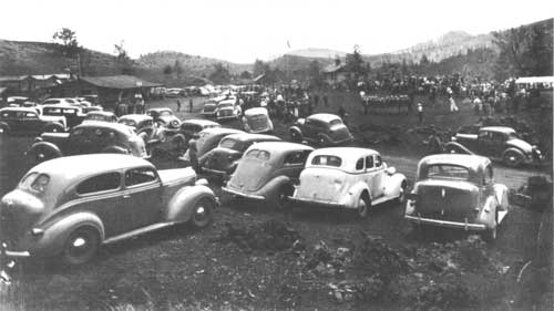
| The crowded conditions of Opening Day, 1939, give some indication of growing pressures on monument resources. (CRMO Museum Collection) |
Taking Action
Protective measures at this early stage were employed out of necessity and were mostly informal. Impacts like collection do not appear as issues in early Park Service reports. With low-level tourist use, custodians were better able to monitor visitor activity, or at least contact visitors as they entered the area. Moreover, Custodian Paisley's creation of an outdoor display of lava samples in 1926 may have alleviated some rock removal, allowing visitors to touch but not take volcanic specimens. [15] Even so, impacts to geologic resources present at the monument's inception evolved into an ongoing issue that area managers eventually needed to address.
The Posse Dash
A variety of visitor activities jeopardized volcanic features. During the monument's formative years, for instance, damage to geologic formations occurred through a seemingly innocent activity--the annual Opening Day celebration conducted at the monument every spring since the area's creation. The fanfare included picnics, speeches, music, and the famed Sheriff's Posse Dash, all of which was sponsored by the Butte County Chamber of Commerce. The event attracted several thousand spectators. Overflow parking covered both sides of the entrance road and filled the campground. Over all, the festivities formed an important public relations activity and constituted considerable work for the small monument staff preparing for and controlling the crowds.
As a public relations activity the event was a success, but in terms of resource management, the celebration proved destructive. Beginning in the late 1940s and early 1950s, Superintendent Aubrey Houston reported that Opening Day vandalism and collection were on the increase. Houston's experience in May 1952 is as amusing as it is enlightening:
Sometime during the late evening rush of visitors leaving the monument on Opening Day, the 25th, one of our less law-abiding [sic] citizens made off with our prize specimen of breadcrust bomb, which makes me [sic] very unhappy and jars my faith in human nature to its very foundation. I even dreamed that I awoke one morning and found that the whole collection had been carted away. [16]
By 1963 change was in order, and Superintendent Daniel Davis toned down the celebration. It was not only labor intensive for his staff but also damaging to monument's resources. The Sheriff's Posse Dash, an opening ceremony where flag-bearing riders raced horses through the monument's sensitive cinders, "tore the place up," Davis recalled. Vegetation as well as cinders and hardened lava suffered. For these reasons, he eliminated the posse dash altogether. Davis realized that this was a delicate issue. The local groups used the area as a personal playground (as they had for years), and he was an outsider expounding new ecological perspectives on resource management. His decision did not win him new friends within the Arco community and alienated him from some of its members. Given the decades of serious impacts to the geologic resource, Davis felt justified in his decision. Even though he formally eliminated the Posse Dash, Arco community members have broached the subject with more recent superintendents. Robert Hentges, approached regarding the horseback event in the mid-1970s, decided against reinstating the festivity, for the same reasons as Davis. At present, the Sheriff's Posse Dash remains a part of the monument's colorful past. [17]
|
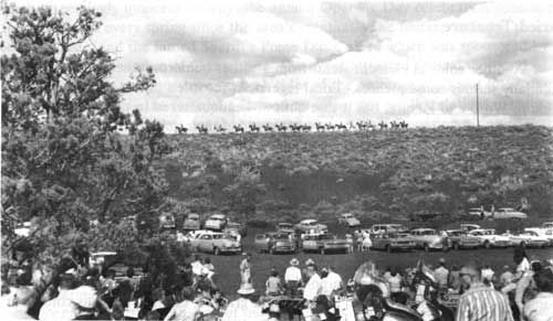
| Lining up for the Posse Dash, a popular yet destructive event at Opening Day, 1961. (CRMO Museum Collection) |
Buried Treasure
Another colorful element stems from a rather humorous anecdote with potentially serious consequences. Local legend, as recorded in the 1937 Idaho: A Guide in Word and Picture, has it that outlaws headquartered in the cinder and spatter cones of Craters of the Moon, and there hid their gold. [18] It was only a matter of time before a request came in to excavate the monument's "hidden treasure."
In November 1949, several individuals from Boise, Idaho, aware of the legend, asked permission to dig for the secret cache supposedly in or near the formation known as the "Old Man of the Craters" on the southern slope of Paisley Cone. Believing they had located the site through suspect means, Superintendent Aubrey Houston denied their request until he gained confirmation from his superiors. For the Park Service, the situation caused a policy dilemma. At first, the Service "reluctantly recommended" that an excavation permit might granted, because this was consistent with agency policy and there appeared to be no valid reasons to deny the request. However, the proposed excavation was to occur in an area of monument's highest "value and use" and would leave an irreparable landscape scar. Stating that the excavation was inconsistent with the monument's purpose and the Park Service's mission, Western Region Director Lawrence C. Merriam denied the treasure hunting permit in April 1951. Nevertheless, the story resurfaces periodically, exciting more interest and eliciting more agency denials. [19]
"Hot Rods" and Cinder Cones: Off-Road Driving
A more destructive form of human erosion originated in the monument's early years as well. Driving across the cinders and fragile geologic features at the monument occurred prior to and after the monument's establishment. Both explorers and sightseers left the primitive road system and ventured unrestrained (as did pedestrians) across the delicate cinders creating troughs and tracking footprints in the process. Compaction of the sand-like cinders left an indelible image for years, altering the color of the surface in places and leading to the growth of vegetation in the depressions. In addition to these "cosmetic" scars, early auto travelers frequently sunk into the cinders, spinning deep ruts and breaking limbs off of limber pines for traction. [20] Brittle, hard-surfaced lava formations also suffered permanent damage. This situation was perhaps inherent to Craters of the Moon because of its enticing rolling terrain and informal road system. At first developments played an important role in mitigating this destructive activity. Custodian Albert T. Bicknell--with the help of the emergency conservation work programs in the early 1930s--tried to resolve the issue through the erection of rock barriers along the monument roads and the establishment of more formal trails to prevent cars and their drivers from wandering off onto cinder slopes.
However promising these developments appeared, they were not enough of a deterrent some thirty years later. Even after Mission 66 modernized the monument's loop drive and adjacent roads, rising visitation increased number of incidents, suggesting that the problem was here to stay. Confronted with a rash of off road-driving by local youths from Arco in March 1961, Superintendent Henderson increased protection by initiating night patrols. He exhorted that such actions were contemptible, should be actively opposed, and viewed as "an act of vandalism." [21]
Two years later, Superintendent Daniel Davis acted on this directive and recorded what is probably the first enforcement against off-road driving at the monument, writing that the Butte County Sheriff returned four California youths to Craters of the Moon for driving across cinder cone slopes with their "hot rods." Davis punished the youths by making them rake out their tracks, a policy incorporated into the first resource management plan. [22] Active enforcement and public contact, as practiced by Davis, helped to alleviate but not cure the problem. In a small measure, the problem persists; the wide trail up Inferno Cone, for instance, occasionally attracts four wheel drive vehicles. [23]
Cinder Hauling and Vandalism
Off-road driving was indicative of rising damage overall to geologic features in the 1950s with expanded protection forming the management response. For example, in October of 1952, Superintendent Houston discovered that cinder hauling was taking place since the cinders were attractive for landscaping, an occurrence likely attributable to the region's construction boom. After discovering the activity, Houston increased patrols, two to three times a day, and resolved the problem. [24]
Outright vandalism during this period, however, underscored the obstacles a small staff encountered protecting the resources. In August 1953, Ranger Robert Zink discovered that some hikers had ventured four miles south of the Tree Molds parking area to Trench Mortar Flat where they "attempted to dig up one of the lava trees," vertical tree molds believed to be the only type in existence. Zink lamented that a lack of personnel to patrol the closed area (now wilderness) or funds for protective fencing found the administration unable "to control the activities of such visitors." [25]
Reflecting the expanded administrative capacity set in motion by Mission 66, Superintendent Henderson took steps to offset vandalism in other areas of the monument, initiating the construction and installation of the gate at Arco Tunnel in May 1961. The gate also provided for visitor safety. And in August, the superintendent increased ranger patrols "in an effort to discourage the removal of rock samples and vandalism to some of the more heavily visited features." [26] As part of this protection and public information program, two months later Henderson erected five signs warning "visitors that specimen collection is prohibited." [27]
Devil's Sewer: The Lost Feature
Increased patrols, warnings, and signs, however, failed to completely prevent the destruction of volcanic features. The impacts represented a process that transpired over a long period of time, and by 1962 their effects appeared in the Devil's Sewer formation situated in the North Crater Flow. [28] The lava section contained a variety of interesting features including aa and pahoehoe lava flows, a pressure ridge, squeeze-outs, monoliths, common plant life of the pahoehoe habitat, and the famous 1,350-year-old Triple Twist Tree. The central element of the area was a long lava tube known commonly as the "Lava Snake." Accessible from the first turnout along the loop drive and by a 300-yard trail, the site received a great deal of use. In the late 1940s and early 1950s Superintendent Aubrey Houston called attention to its impairment intensified by the Opening Day celebration, whereby "Vandalism is a constant threat to some of the most interesting features. As an example, the Lava Snake has been so badly damaged by souvenir hunters or destructive vandals as to be unrecognizable." [29]
Almost forty years of this activity and off-trail hiking across the brittle rock eroded the feature until it had virtually disappeared. In September 1962, Superintendent Merle Stitt pronounced its destruction: "once a 35-foot squeezed-out tube of geological importance, [it] has been completely destroyed by thoughtless visitors. Approximately 2-1/2 feet of this formation remained at the beginning of the 1962 travel season." [30] Afterwards the area was still interpreted but the feature's diminishment redirected interpretive efforts to other features within the North Crater Lava Flow. [31]
|
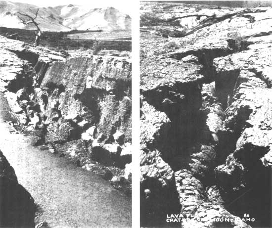
| The photo at right reveals an intact portion of the "lava snake", ca. 1940s or 1950s; the photo at left feature's destruction, ca. 1962. Note the proximity of the trail to the feature. (Left photo, CRMO Museum Collection; right photo, courtesy Glenn Hinsdale) |
SETTING DOWN GUIDELINES: THE 1966 RESOURCE MANAGEMENT PLAN
Impacts to the geologic resources eventually found their way into monument resource management policy. The destruction of the Devil's Sewer lava tube exemplified the deceptive fragility of lava formations and the long-term effects of unauthorized collection and uncontrolled human use. Other features were equally susceptible to loss. The 1966 resource management plan documented the gravity of the situation and set down guidelines to mitigate destruction of the monument's "non-renewable" volcanic resources.
Speaking of collection, Superintendent Roger Contor stated in the report that "Craters of the Moon has passed the point of diminishing returns regarding collection of geologic specimens." From now on, monument policy would consider the collection of cinders and lava samples within the monument no longer necessary or appropriate because plenty of similar examples could be found outside the area's boundaries. Volcanic phenomena such as tree molds and lava bombs were believed to be unique to the monument; considering their past collection and depletion, "those remaining are now invaluable." [32]
Therefore, given the sparsity of volcanic phenomena in the monument's core, Contor noted that only bone fide scientific collection should be allowed throughout the monument as a general rule, and that the administration should carefully screen each request. A college or university's interest in building a "representative collection" of the monument's geology "is no longer adequate justification." Groups of geologists and students from across the country visited the monument annually in search of lava bombs, for example, an activity referred to in "local universities as a 'bomb raid on the Craters.'" [33] This was no longer an acceptable activity.
Mitigation of collection would best occur through the adherence of strict guidelines for specimen removal for scientific research, the expansion of a public awareness campaign to reduce specimen collection and collateral vandalism, the continuance of roving patrols with additional rangers making visitor contacts, as well as the establishment of state laws that would prosecute rock collectors and vandals in Idaho judicial courts. [34] In the case of the latter, Contor announced that in March 1966:
The Butte County Commissioners passed an ordinance...(No. 198) prohibiting any act that "disfigures, defaces, destroys or removes any object or thing of archaeological, historical or geological interest or value on private land or within any public park in Butte County." This ordinance will enable Monument personnel to utilize the Butte County Justice of the Peace for the above violations. [35]
Damage to the monument's volcanic features caused by regular visitor activity received equal attention in the plan. The Devil's Sewer was but one example of unrestrained visitor exploration. Deterioration was often subtle, detected not necessarily from the ground but rather from the air. As Superintendent Contor observed, from "an airplane one can easily spot areas of human use by the red-brown coloring of the broken surface, as contrasted with the oxidized grey of the undisturbed surroundings. Even casual walks into the roadless areas create minor but cumulative damage." [36]
Contor believed that vandalism or social trails created by visitors bored with a certain trail or site could be avoided by the construction of loop trail systems. He thought of Devil's Orchard Trail as a good example, and mandated in the plan that where possible present and future trails should follow this precedent--specifically, North Crater Flow interpretive trail, Indian Tunnel trail, and if feasible, the route between Beauty and Surprise Caves. [37]
Visitor protection also played a role in resource protection. Echoing earlier concerns over destruction to fragile features and increased use, Contor recommended that the installation of "protective walks, ladders, enclosures or barriers in the tree mold and Spatter Cone area" along with other sites should be built commensurate with "public use demands." As for visitation, control of people was key to the success of the resource management program. [38]
Rising visitation exposed design flaws and resource threats. The campground, for instance, was too small for current use and thus projected increases in visitation, and more importantly, it was located in a sensitive area, the North Crater Flow. Therefore, Contor proposed closing the campground and possibly relocating it in the Little Cottonwood Creek basin to further protect geologic formations. [39] Similarly, anticipated growth in visitation required an expanded circulation network to avoid congestion and resource impairment. Contor thus offered the expansion of the loop drive around Big Cinder Butte as a possible solution. [40]
Although neither proposal was implemented, [41] protection of the volcanic resources showed significant improvements with the drafting of the 1966 plan. It established policy guidelines adhered to over the next several decades that to this day remain largely unchanged. Managers, however, would always be faced with a "winless" situation. As Superintendent Robert Hentges noted in 1980, for instance, the "removal of volcanic phenomena still plagues the park and probably always will, regardless of the information we attempt to provide the park visitor concerning this problem." [42] Today, collection continues to be a problem along with other forms of human erosion. All are managed through aggressive interpretation and enforcement, including "on-site interpretive programs, articles and regulations in handout material, signing, personal contacts and law enforcement actions." These methods, while not stopping injury to lava features, have struck, in most cases, a workable balance. [43]
SITE-SPECIFIC DISCUSSION: FRONTCOUNTRY GEOLOGICAL FEATURES
While general policies to protect the lava terrain were in place by the mid-1960s, the most dynamic resource management efforts have taken place within the past twenty years, focusing primarily on the frontcountry sites. These areas--the North Crater Flow, the Devil's Orchard, Inferno Cone, Big Craters and Spatter Cones, Tree Molds, and the Caves Area--are located along the loop drive. Together, they characterize the monument's intrinsic value, uniqueness, and inherently "weird and scenic" qualities mentioned in the enabling legislation. In a larger sense, this collection of outstanding features exemplifies all the major features found within the reserve, as well as the problems associated with their management. Because the various sites are close together, connected by the seven-mile road system, visitors can experience the essence of Craters of the Moon up close and in a short period of time (2-3 hours). Yet this attribute also contributes to site deterioration since the frontcountry receives the most concentrated visitation, an average of 200,000 annual visitors, the majority of whom visit during the summer months. [44] Consequently, monument administrators, faced with increased impacts, have implemented programs to better protect and rehabilitate the frontcountry lava features while still allowing for visitor use, making the region a continuing resource management concern.
North Crater Flow
The North Crater Flow presents fine examples of ropey pahoehoe and aa lava flows, along with the remnants of crater walls transported by the same flows. The closest site to visitor facilities, the area received heavy use as the disappearance of the Devil's Sewer lava tube in the early 1960s attests. Although the short nature trail at the North Crater Flow introduces visitors to the monument, the interpreted area lies adjacent to the campground located in the same flow, but separated by a low ridge. Over time, social trails have radiated from the campground as visitors explore the lavas or short-cut over the hill to reach the site rather than walking the loop drive. Considering the North Crater Flow as sensitive terrain, Superintendent Contor suggested removing overnight camping facilities from the area altogether in the mid-1960s. Subsequent management plans failed to see the necessity, deeming the relocation of the campground to the northern unit as administratively unfeasible. Furthermore, by 1980 the value of the north end as a high desert ecosystem was recognized precluding any development.
By 1991, the geologic resources of the ridge separating the campground and North Crater Flow parking area had sustained serious impairment, and managers were compelled to seek corrective action. Unable to move the campground, they instead concentrated on the poor circulation design. Campers were more inclined to traverse the ridge since the alternative was the loop drive, which makes for neither safe nor pleasant walk. For these reasons, Superintendent Robert Scott undertook a trail construction and rehabilitation project in the summer of 1991, establishing "a designated trail from the campground to the North Crater Flow area." By obliterating informal trails, developing a regular trail maintenance and rehabilitation schedule for social trails, and continuing enforcement of regulations to prohibit off trail use in the North Crater Flow, he believed, will result in "long-term rehabilitation/protection of a sensitive and heavily used area." [45]
Devil's Orchard
Here rafts of lava fragments stand like islands in a sea of cinders, possibly marking the vent of an ancient cinder cone. Lava bombs lie scattered about the cinder slopes, and springtime flora displays are glorious in the cinder gardens when dwarf monkey-flowers mat the ground with a magenta cast. One of the oldest sites visited in the monument, Devil's Orchard attracts a large number of visitors who tour the "weird" features along the short interpretive trail.
Built in 1963, the third of a mile, self-guided interpretive loop trail was part of the monument's developing interpretive program, the first area to concentrate on the lava landscape's natural history. Although superintendents such as Roger Contor favored the loop trail design for its protective qualities (circulating visitors in order to hold their interest and keep them on the trail), the design was not effective enough. Social trails braid the area; vandalism is frequent, and rock collectors have scoured the vicinity of its lava bombs. Because of its role in interpretation, Superintendent Scott approved a pilot program in the summer of 1991 to interpret both the site's and the monument's natural resource management problems at Devil's Orchard, thus involving visitors and making them more aware of resource impacts. The experiment was considered successful and on the "cutting edge" of interpreting natural resource management; a formal trail rehabilitation program and revised interpretive approach were underway in 1992. [46]
Big Craters-Spatter Cones
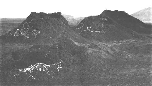
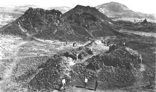
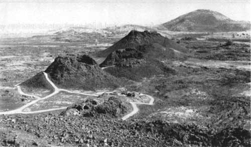
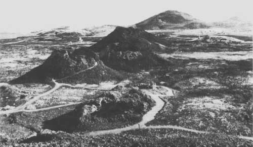
One of the most distinctive and popular sites at Craters of the Moon is the Crystal Fissure Spatter Cones. They formed along the Great Rift when clots of pasty lava stuck together during an eruption, building steep-sided, chimney-like vents in the process that look like miniature volcanoes. The spatter-cone chain at Craters of the Moon is considered one of the most perfect chains of its kind in the world. The chain is composed of three main vents and a fourth and smaller vent in the foreground, called Snow Cone. [47]
Because of their popularity, the Spatter Cones have been the focal point of the most intensive management and rehabilitation ever undertaken at the monument, most of it within the last decade. The vents, in a sense, epitomize the management of volcanic formations at the monument; they are both beautiful and fragile and open to public viewing and contact. Over the years, unchecked exploration wore a lacework of trails into the sides of the cones, sloughing off the delicate cinders on their slopes, caving in sections of one crater's wall, and eroding more than two feet of material from the rim in the process. Visitors throwing rocks and garbage into the vents altered the insulating properties of the features, raising the bases, and causing the possible disappearance of perennial ice. At risk as well was visitor safety, not only from climbing the cones but also from falling inside. Unrestrained activity altered the appearance and integrity of the spatter cones by the 1960s, making imperative rehabilitation efforts for their preservation and use.
Site History and Management
Human erosion of the spatter cones was evident early in the monument's history. Photographs from the early 1920s compared with those of late 1930s, for example, display the conical vents with social trails worn into their sides. [48] At the same time, resource management efforts consisted of cleaning the cones of trash, often with the assistance of local Boy Scouts in the absence of enough personnel. [49] In the fall of 1954 a formal trail was laid around the Spatter Cones, but most visitors still roamed the cones at will. Not until the early 1960s does any discussion of corrective measures surface in monument records. [50]
In the wake of Mission 66's improvements to the monument's resource management, Superintendent Merle Stitt, as he had at Devil's Sewer, identified the Spatter Cones as a high priority for protection, stating that "Collective damage to spatter cone formations over the period prior to and subsequent to the establishment of the Monument has reached serious proportions." To remedy the situation, Stitt embarked on a study to address corrective action, and in January the following year, the monument submitted its first report on human erosion of the Spatter Cones to the director of Western Region. Yet the record is quiet as to any response by the regional office.
Without any formal program in place, management efforts remained sporadic. For safety, Superintendent Davis installed a grate over Crystal Fissure in 1963, and the following May, the monument once again enlisted the assistance of a Boy Scout troop to obliterate social trails from the slopes of the cones. [51] In September 1965, Superintendent Roger Contor initiated another study to protect the Spatter Cones. Contor, making no mention of the previous report, and implying that the problem had not been resolved, noted that the "present trail system and visitor flow pattern is causing adverse use...." [52] In his 1966 resource management plan, he urged a program to control visitor use and restore the features to a more pristine state. Rehabilitation of social trails, largely responsible for erosion, had failed to mitigate the problem. Hence, Contor decided that a "series of paved, fenced trails and unobtrusive barriers appears to be the only solution." [53]
When Superintendent Paul Fritz arrived only metal handrails enclosed the cones and served as protective devices. Although Fritz planned to complete the improvements recommended by Contor, only "stop-gap" measures resulted--the erection of more handrails and chain-link fencing for safety reasons, and the reconstruction of shoulder material on social trails to combat erosion, in addition to general enforcement and interpretive programs. [54] Yet these were not enough. Upon his arrival at the monument in 1974, Superintendent Robert Hentges underscored the deteriorating condition of the Spatter Cones in his reports and like his predecessors emphasized the cones as a primary target for resource management. The trail networks on the precipitous slopes tainted the aesthetic experience, and contributed to the cones' deterioration. Rocks thrown in the throats of the vents had decreased the depth of the volcanic wells so much that winter snows and ice were melting at a faster pace--all because certain park visitors get enjoyment out of "chucking things down into holes in the ground." [55]
Once more delays emerged to stall any action. Unsure about funding, Hentges did not submit a Development Study Package Proposal (10-238) to rehabilitate the spatter cones site until 1979. The project was intended to balance preservation and use; it would "provide a safe trail system" in order to "insure minimal impact and still allow the visitor to safely experience the spatter cones." [56] As the monument awaited funding, the site nearly reached "the point of irreversible resource destruction." [57] In the meantime, the monument depended on existing procedures and an extensive public information campaign to inform visitors and solicit their support in mitigating impacts. [58]
Rehabilitation began in 1982. The project's major objective, ringing of suggestions voiced over the past three decades, was to improve the aesthetic and natural qualities of the features. Using historic photographs monument managers determined the cones' pristine state with their present state, and determined what an appropriate rehabilitation of the landscape should seek to achieve. Overall, rehabilitation the program rehabilitated all cones, yet only Snow Cone and the second cone were left open to public use, making them the exemplary features of the chain--a decision, Hentges believed, which best met the monument's and agency's mission. [59] Both monument staff and a five-member Youth Conservation Corps (YCC) crew engaged in the labor-intensive program. Workers reshaped the Spatter Cones, hauling cinders and lava rocks from the base of the cones back up to their rims and sides. They upgraded existing foot trails, two of which were obliterated along with more than a thousand feet of social trails. Similarly, they rehabilitated around two thousand square feet of compacted land at the base of cones. About two hundred feet of asphalt trail was improved by the addition of a concrete retaining wall, and steps up to the mouth of the main vent were constructed. The metal handrails, considered unsightly around the first two cones, were replaced with wood railing.
By end of this phase of the project, paved and unpaved trails led up to and around the two open cones. On the second cone the main trail had been rerouted to run along the eastern face of the vent, and trails running the length of the chain had been closed, restricting visitors to designated and signed trails. A new wayside explained the resource management problem and fragility of the Spatter Cones, and the park newspaper and other pamphlets carried a similar message. [60] In August 1985, Superintendent Robert Scott pronounced the spatter cones project "an unqualified success." He noted that "Not only were the geological features rehabilitated, but visual impact in the area was significantly reduced and the visitor can visit the area safely." [61]
Smaller rehabilitation projects were completed in 1987. These involved hard-surfacing approximately 120 feet of trail leading into the second spatter cone, replacing the handrails at the Snow Cone with a sturdier railing designed in an environmentally sensitive manner, and transplanting native vegetation near the parking lot's southern edge as a method to channel foot traffic into the trail system. [62] At present the standard operating procedures at the site include monitoring trails, educating the public through interpretation and signs, and maintaining the trails. All of this helps to protect the cones and ensure visitor enjoyment and safety. Even so, the spatter cones, in spite of the rehabilitation efforts to date, still receive noticeable impacts due to their immense popularity, fragility, and accessibility. [63]
|
| The Spatter Cones as they appeared in 1924. (Haynes Foundation Collection, Montana State Historical Society) |
|
| The Spatter Cones receiving heavy visitation in the 1950s. Note the braided trails on the slopes. (CRMO Museum Collection) |
|
| The Spatter Cones after undergoing trail maintenance in the early 1970s. (CRMO Museum Collection) |
|
|
The Spatter Cones after intensive remediation, mid-1980s.
(CRMO Museum Collection) |
Inferno Cone
Situated near the Crystal Fissure Spatter Cones, Inferno Cone is a cinder cone, a conical mound formed by the accumulation of volcanic cinders around a vent erupting along the Great Rift. Although Inferno Cone is one of twenty-five cinder cones within the monument, its major significance lies in its use as a viewing platform: the panorama of geologic diversity seen from its crest is impressive. The landscape one scans embraces a series of mountain ranges northeast and west of the monument, the surrounding Snake River Plain, and the chain of volcanic features lining the Great Rift. In addition, the clarity of the monument's Class I airshed can be experienced here as well, a common sight being Big Southern Butte, a national natural landmark lying some twenty-five miles southeast of the monument. [64]
Inferno Cone also represents another example of preservation and use at the monument. As visitors trample up the cone's slope to view the feature and the surrounding region, they cause the trail leading up the cone's southwest face to suffer from compaction, widening, and discoloration. One of the most vexing questions for administrators has been the origin of the trail itself. More than likely, the trail formed out of social or casual use in the early 1920s when the loop drive was first bladed through the area. Subsequent management plans of the 1960s and 1970s call out the feature's use as a vista, but do not stress any type of resource management problem. One management plan even expressed that the cone was not the optimum choice for an overlook and proposed Sunset Cone in the northern unit as an alternative. On the other hand, the interpretive program contributed to Inferno Cone's increased use by including it in nature walks in the 1970s. [65]
The problems with the Inferno Cone trail, in this respect, represent a more recent issue for management. In the early 1980s, the monument initiated a program to control the trail widening process occurring with visitor use and to minimize the extent of the compaction and discoloration. At that time, the unmarked trail could accommodate several hikers walking abreast and was wide enough to entice operators of four-wheel drive vehicles to forego the formality of the short hike and drive to the summit.
Robert Hentges and his staff thus undertook two mitigation programs: break-up the trail edges, and better define the trail route. During 1983, the monument employed YCC labor to manually spade and dig up the existing trail. The crew decreased the trail to about ten feet in width. As Hentges recalled, this worked out "beautifully, but of course, by the end of the year it hedged back out three more feet." The next step involved a tractor and a harrow driven up and down the trail to tear up the compacted tread. Visual disturbance formed an early drawback of this method. In contrast to the black cinder surface, the lava is "a nice bright color when you go under," Hentges noted, "but one day its matches out perfect. So [we] just harrowed, you know, with the old spikes, and ripped it up. And that did it." [66] The compaction was diminished, the trail narrowed, and the discoloration alleviated. Apparently, the trail marking program was never implemented, due to the fact that hikers would continue to walk around the lava rocks demarcating the edges.
Although somewhat successful, one management solution led to another problem. Inferno Cone, for example, received greater use as a result of restrictions imposed on the Spatter Cones during their rehabilitation and their restricted access following the project. Having tilled the trail for several years, the monument discontinued that approach in 1985--at the insistence of regional office staff during an operations evaluation. Responding to the evaluation team's recommendations, Superintendent Robert Scott launched a five-year monitoring program to document the trail's compaction, erosion, and widening. [67] Data collected would be used to determine the nature of the problem and whether or not surface erosion would continue after compaction had occurred. The program also called for measuring the trail each fall and for comparing those findings with stakes marking previous widths. [68]
The program turned out to be a failure. During the first year, wooden stakes were either destroyed or lost; new stakes were planted and read the next year, but were stolen by visitors the following season. By the fourth year, managers used buried metal stakes and lost half of them, and in the fifth year, using a metal detector, came up with the same results. In 1989, the monument terminated the monitoring program. Managers felt that the impacts were obvious and explored management options, but these are somewhat controversial, raising the question of aesthetics and resource protection. The point is whether use of the trail should continue, and with it the growing scar visible throughout the monument, or whether some alternative be sought. [69]
As the most recent resource management plan states, one proposal would close Inferno Cone trail altogether and construct another to the top of Big Craters to allow visitors a similar vantage point of the landscape. This would eliminate further erosion of the existing trail, but it is doubtful whether an intensive and possibly expensive rehabilitation program could fully eradicate the trail, or for that matter keep visitors off the closed trail. Furthermore, creating another trail, it is thought, would only multiply resource damage. The proposed trail to the rim of Big Craters, for example, had been tried before in the late 1960s and early 1970s as an interpretive vista, but was later closed due to erosion problems--visitors often climbed down the crater wall to reach the parking lot instead of returning by the trail. Similarly, another proposal suggests relocating the Inferno Cone trail, constructed as a switchback, to the cinder cone's leeward side, which would also require development of a new parking area. Whatever conclusions are reached, any solution places the fragile lava terrain in some kind of jeopardy, and places monument managers in the position of determining an acceptable balance between preservation and use. [70]
Tree Molds
Tree molds are generally found in the monument's remote wilderness backcountry, yet from the end of the spur road south of Inferno Cone, a short trail provides easy access to some of these features. Formed when molten lava flows encased trees and then hardened, tree molds are the cylindrical casts of trees that have burned and rotted away. Vertical and horizontal, the features are delicate, as made clear by Robert Zink's report in the early 1950s, when he discovered the damage to one of the molds at the hands of irresponsible collectors. At one point, Superintendent Roger Contor thought of using plexiglass domes to protect those features exposed to visitor contact. [71] After 1970, wilderness status ensured restricted development and use. While the percentage of visitors who hike into the wilderness is substantially smaller than those who venture into easily accessible sites, the fragile tree molds remain highly susceptible to impairment. Even though only one sign marks their presence, the most vulnerable are those representative tree molds located a mere one mile hike from the road and confined to a small area. [72]
Caves Area
Caves, in the form of pahoehoe lava tubes, spatter cone vents, and fissure caves, are found throughout the monument. They are a significant feature of Craters of the Moon, and are specifically identified in the unit's enabling legislation as being important for their "scientific value and general interest." However, no formal management plan for the caves exists. Reasons for this stem from the usual lack of funding and personnel to patrol these extensive features; management requirements vary from cave to cave, because of their differences in origin, length, size, and accessibility. And until recently, it was thought that unlike many of the other features in the monument, the caves possess "no truly unique or fragile resources that dictate special management needs." [73] Except for the popular developed caves site, most caves are remote and this factor governs their management as wilderness, in or outside the wilderness area's boundary, in that they are generally left alone and unadvertised.
Furthermore, management policies emphasize visitor safety in the caves through interpretive programs, visitor contacts, and, in some instances, facility developments. Over the years, the issue of cave safety has sustained considerable concern in the subterranean environment where visitors encounter unstable rock formations, ice, total darkness, uneven surface areas, and low heights, and, in most cases, require some type of technical assistance for cave exploration, such as flashlights or ropes. Minor injuries and the administration of first aid to visitors are common occurrences associated with the caves.
With the appearance of the 1982 resource management plan, though, the monument identified for the first time, the need for a cave management plan. This grew out of the belief that the monument had fallen short of its enabling mandate to protect its caves, coupled with the recent Park Service initiative to develop a comprehensive resource inventory. Thus the plan noted that the monument needed to detail "specific management programs for individual cave sites. These management programs will vary according to the resource needs and use classifications of each cave." [74]
While such a plan has yet to be drafted, the monument has established some formal policies for the caves. Generally speaking, managers consider caves in the same realm as archaeological resources, and except for certain representative sites, discourage entry. Except for some sites in the frontcountry, managers strive to preserve and protect the caves in their natural state, especially their water sources and wildlife.
Conversely, the "developed" caves region along the loop drive is one of the most popular areas of the monument. Paved and marked trails extend from the parking area to easily accessible caves (Dewdrop, Surprise, Beauty, Boy Scout, and Indian Tunnel) that require neither special equipment nor training to enter and explore. Only the longest tube, Indian Tunnel, has received any significant development, however, through interpretive signs, a marked walking route, and a metal stairway for access; natural light enables visitors to explore its inner reaches without artificial light. The other caves, while open to visitation, have been left undeveloped and they require a light source. Management of the area requires more time and energy, accomplished through interpretive programs (daily guided walks and self-guiding tours throughout the summer), and daily ranger and cleanup patrols.
As exhibited by the management of Indian Tunnel, cave developments were implemented with visitor use and safety in mind. For example, both Arco Tunnel and Great Owl Cavern were outfitted with various types of ladders, and stairs made from rope, chain, wood and metal; [75] the progression toward more stable structures was made for safety reasons after 1934. Access to Arco Tunnel degraded resources, mostly through vandalism, and led to the installation of a wire gate in May 1961. From that period forward the lava tube was accessible only by registration and special-use permit, and was a site for occasional research. [76]
While the gate continues to work well at controlling entry, damage through vandalism has resurfaced periodically over the past twenty years, requiring gate repair and the volunteer efforts still persists at the site. To care for the site, the monument has relied on members of the Gem State Grotto, a local spelunking club, who in 1983 volunteered their time to clean the florescent-orange graffiti arrows from the tunnel's walls and install a new security gate at its mouth. Unfortunately, no solution compatible with the resource has been found to remove the glowing arrows. [77] In contrast to the high-use site, Great Owl Cavern's stairway was removed in 1972, in compliance with wilderness regulations, and is now accessible only by rope or ladder. As with other remote caves, managers discourage exploration of the site since it requires technical climbing, and the repelling equipment can damage the cave itself. Not signed, it has in a sense faded from existence.
Whereas the remoteness of many caves lends itself well to ensuring their preservation, pressures on cave resources have become more acute in recent years. Managers, although discouraging cave exploration, were obligated to divulge the location of caves through the Freedom of Information Act. Maps also documented their location, exposing caves to more threats. One significant example has arisen over the exploration of Crystal Pit. Because the crystals are extremely fragile and the pit is extremely deep, requiring technical climbing, the cave has been closed to public access since August 1963. But it appears from damage to the grate that Crystal Pit has been entered over the years, and within the last few years, a group of cave enthusiasts has filed an official protest to explore the site. Furthermore, research has documented at least two rare species living in the monument's caves, the Blind Cave Beetle and the Townsend Bat.
With the passage of the Federal Caves Resources Act Protection Act in 1988, which mandates the study of cave resources and the identification of significant caves, managers received further impetus to complete a cave inventory and management plan. By doing so, they can address these and other issues. The legislation itself provides management assistance. It officially places caves in the category of archaeological sites, for instance, enabling managers to withhold information from the public except under specific conditions. For this reason especially, the monument proceeded with an inventory and management plan. [78] Relying on volunteer labor over a period of several years, since there was neither funding nor personnel to conduct such an extensive study, the monument hoped to have its plan drafted by 1992. [79]
VEGETATION
Although the volcanic landscape of Craters of the Moon appears to be a trackless waste, it supports a wide array of plant life. The monument's lava flows contain twenty-six vegetation types and over three hundred plant species. Cinder cones, the Carey Kipuka, and the northern unit, for example, sustain various plant communities of lichens, grassses, herbs, shrubs, and trees. Management issues have revolved largely around the control of trespass grazing in the north end, to a lesser extent, control of exotic species, fire ecology, and protection and study of the Carey Kipuka.
GRAZING
By far the most protracted issue, trespass grazing, mostly by sheep, has plagued monument managers nearly from the area's inception. The place of contention lies in the foothills of the Pioneer Mountains in the north unit; this environment possesses Little Cottonwood Creek drainage (source of the monument's administrative water supply), traditional grazing lands, and lush vegetation: native grasses, Douglas fir, aspen, and other riparian plant life. The monument did not inherit the grazing problem upon its establishment. The original legislation included only what might be termed "worthless" grazing lands south of the foothill country. But with the enlargement of the monument in July 1928, Craters of the Moon acquired more than two thousand acres of hill country for its administrative water supply and with this lands grazed by livestock. And so began a long history of mitigation policies for trespass grazing.
Roots of Controversy
Expansion, among other things, incorporated the Little Cottonwood Creek drainage to secure an administrative water supply. The grazing issue was connected generally with this expansion and specifically with the water system land exchange. The monument's enlargement and the resolution of private holdings incited protests from some livestock interests who questioned the intentions of the Park Service and its encroachment on the "public domain," and more important, its policy regarding grazing in the new area. Throughout the settlement of private claims in the late 1920s and early 1930s, the controversy boiled down to clarifying the Park Service's grazing policy at Craters of the Moon, specifically in the northern unit.
A major source for the controversy has been the boundary. As the management of the mule deer herd and poaching demonstrates, the northern boundary was not drawn to conform to topography but rather the grid pattern of township and range. Instead of following the hydrographic divide--or ridgelines--and therefore being readily apparent, the border runs a seemingly arbitrary course up and down the northern slopes. This poses a particular problem for the prevention of livestock grazing, since sheep and cattle unless restrained by attentive herders or sturdy fences will roam at will in search of greener pastures. Due to the boundary and the fact that federally administered and privately owned grazing lands abut the monument, trespass occurs. The Park Service boundary invited this type of controversy because the lands involved were at one time part of the open range and also part of a seasonal sheep migration route.
The First Grazing Policy: The Stock Drive Path
On October 5, 1929, Custodian Robert Moore notified the Washington office that stockmen had used the grass on Sunset and Grassy Cones prior to the monument's 1928 expansion, and had "trailed through that way" for years driving their sheep from winter to summer range and points of shipment in the Wood and Lost River regions. Because of this precedent, Moore recommended that the Park Service designate a driveway to accommodate this activity, covering virtually the entire northern unit. [80]
Amenable to Moore's suggestion, the Park Service responded on October 24 stating that it was willing to make an exception to its general policy of grazing prohibition in national monuments and parks "in view of the conditions at Craters of the Moon there would appear to be no objection to permitting sheep men to drive their flocks through the monument area, though it would be unwise to permit them to graze on Grassy and Sunset Cones and other areas while en route." [81] The one requirement was that all stockmen receive prior permission and that the stock move through "uninterrupted."
Since Moore's conception of a stock drive path covered most of the northern foothills, he believed that no "officially" designated path was warranted. None had been established during the years of open range. As long as livestock owners directed their flocks along the north half of Sections 25 and 26, the Park Service could in fact allow for seasonal passage and grazing to continue. The northern unit had been acquired more for its water source than its volcanic phenomena, the custodian reasoned, showing a bias for grazing interests and a limited understanding of the importance of the area's vegetation for sustaining wildlife populations. Sheep confined to the northern foothills would not "destroy any of the scenic points of interest." [82] On November 11, 1929, the Washington office agreed to authorize grazing, by permit, on the lands recommended by Moore, including all of Section 27.
Yet this policy was short-lived. The following year, on May 12, the Park Service permitted the first and last stock owners to graze on monument lands during this period, authorizing the Martin Brothers to run three hundred head of sheep on the north half of Sections 25 and 26, and 34, and all of 21, 22, and 27. However, it soon became apparent that this "limited" grazing policy would not be effective because it excluded other livestock owners with interests in the northern unit. One of these parties was the Arthur Brothers who owned an eighty-acre parcel of land. The Arthurs, and any other land owners grazing in the monument, were stranded, their operations precluded by government lands surrounding their holdings in which grazing was prohibited. After Custodian Moore informed the Arthurs of this fact and that they could no longer water their sheep on monument land, they alerted Idaho Representative Addison T. Smith. Smith urged the Park Service to reach some type of settlement--either exchange the lands or grant the Arthurs permission to use the water. The Service notified Smith that "we would be glad to negotiate an exchange of lands and get the necessary authority in law therefor." [83]
As part of the water system's development, the Park Service was trying to acquire private lands in the northern unit, and the grazing issue seemed to give it some leverage in the negotiations. Yet, as the Arthur case showed, there were possible political repercussions involved that might risk successful land acquisitions and by association the water line's construction. The Service, for instance, had renewed the Martin permit on October 12, 1930. Yet less than a week later, Custodian Moore requested that Edward B. Arthur be given the Martin permit instead since the water line needed to run across the Arthur holdings, and a grazing permit might help negotiations. Realizing that this kind of favoritism could only hinder rather than assist the situation, the Washington office decided that the grazing policy was headed in the wrong direction. And at this juncture, it clarified its position, stating to Moore on October 23 that we were "very much opposed to encouraging grazing of sheep in the monuments...." For this reason the agency rescinded all grazing in Craters of the Moon, beginning in 1931. The agency did, however, reach a compromise. Sheep drifting into the northwestern corner of the monument would be tolerated temporarily, "without any recognized rights under permit which might later be pointed to as a precedent." [84]
Not all ranchers accepted the news lightly. Some believed that monuments should allow grazing as a general rule, even though parks did not. In January 1931, Thomas C. Stanford, president of the East Side Blaine County Grazing Association, protested against the Park Service's "exclusionary" policies toward grazing at the monument. First, the 1928 expansion withdrew valuable grazing lands, lands that did not contain any "scenic wonders," and second, the bill to exchange private lands within the monument to complete the water system, H.R. 15877, threatened to remove more lands from the public domain and undermine the livestock industry. Stanford tried to enlist the support of the Idaho congressional delegation, Representative Addison Smith and Senator John Thomas, to defeat or amend the bill to ensure that grazing would continue within the monument. Smith, who sponsored the legislation, ignored Stanford's pleas. But Thomas, trying to help the rancher's cause, ended up supporting the bill, because Director Horace Albright assured him that it would not infringe on grazing interests. [85]
In order to see the exchange bill pass in February 1931, Albright was willing to commit to an agreement on the grazing issue. For this reason, it seems, he was somewhat equivocal about the agency's policy for the monument. He related to the senator that the Service did not reject grazing within the national monuments as long as it did not interfere "with the purposes for which the monument is established." Restrictions, therefore, applied in some instances, but the Park Service, he underlined, has always attempted to cooperate with livestock owners and issue grazing permits when within policy guidelines. [86]
It was clear after the legislation passed that Albright and his agency had no intention of changing the grazing policy set down in 1930. Although Stanford and his fellow association members wanted grasslands in the northern unit designated for grazing or excluded from the monument for this purpose, the Park Service reiterated that no grazing would be permitted. This type of use was simply not compatible with the monument's purpose. Only authorized seasonal sheep crossing and drifting--within reason--would be allowed. The Service justified this position claiming that it had not intentionally acquired prime range lands which did not hold volcanic phenomena and thus not meet the monument's purpose. The watershed was important to the area's administrative purposes; the forage for intensive grazing was minimal (as was water), and the hill country supported wildlife--namely mule deer--with which grazing would interfere. In the 1930 season alone, an estimated fifty thousand "drifted" through the monument, migrating to and from the Wood and Lost River Valleys, as well as from Minidoka, along the lower Snake River region, in the process trampling and overgrazing monument vegetation. [87]
Left to be resolved was the establishment of a stock driveway. Whereas Custodian Moore did not find it necessary to lay out and officially designate one, his successor Burton C. LaCombe did. LaCombe, veteran Yellowstone buffalo keeper, assumed the custodianship in late May 1931 and immediately touched off a controversy with livestock owners when he ordered an unauthorized herd of three thousand sheep off the monument's northern foothills. Up until this point, the grazing policy was somewhat informal; large bands of sheep were driven across the monument to other ranges, and many lingered feeding on monument grass. For example, the owner of the expelled herd, Grover Newman from Jerome, Idaho, confronted LaCombe about his authority to order him off the northern range. Undaunted, the custodian informed Newman that he was enforcing National Park Service regulations that excluded grazing and unauthorized livestock crossing. Newman lodged a complaint with Senator Thomas "to find out what the trouble was." [88]
On May 28, the senator and Thomas Stanford, representing the grazing interests, inspected the northern section with Custodian LaCombe. Stanford told Thomas, who was mediating the event, that he wanted a stock drive two miles wide. LaCombe countered with a quarter-mile path, which Stanford rejected. The custodian, however, stood by his proposal; two miles covered most of the northern unit, which he claimed would only result in grazing of the entire area. As far as he was concerned, the monument was better off without any type of grazing, in transit or otherwise. Neither the range nor water resources of the north unit would support large numbers of sheep, and the monument's purpose was better served by protecting its watershed and promoting wildlife through the habitat protection. LaCombe informed Director Horace Albright that the Park Service could overcome any opposition to his decision because it was largely a regional versus local issue. "The local people that have sheep close by do not want or rather do not trespass on the monument, it is only the migratory sheep from southern Idaho going to their summer range, that did stop and graze at all on the monument." [89]
Although Stanford and Thomas disagreed with LaCombe, Albright supported his custodian's recommendations in a June 12, 1931 letter to the senator. According to the director, the grazing policy was set; seasonal grazing was excluded, but authorized sheep could be taken through the monument "with reasonable dispatch" across a quarter-mile path, three and a half miles long, following "an old wagon road," Goodale's Cutoff. [90]
LaCombe helped solidify the monument's grazing policy by designating the stock drive path and working to limit trespass grazing. But the real measure of the custodian's role and the policy itself came from weathering Senator Thomas' threats of damaging the agency's support in Idaho because of its treatment of grazing interests. [91] As LaCombe had predicted, the Park Service countered any negative publicity by currying public support in the local communities of Arco, Hailey, Blackfoot, and Idaho Falls, excluding Carey where Stanford's grazing association was headquartered. LaCombe's approach, urged by Albright, was to convince civic leaders that grazing would degrade the monument and hinder the development of tourism. The custodian not only met with community leaders, he also joined their ranks in a public relations strategy, becoming a member of various clubs such as the Lions Club, the Arco Commercial Club, and the Idaho State Automobile Association of America. Since those opposing grazing restrictions were a minority and outsiders, and since the local communities valued tourism and the monument as a scenic attraction, they supported protection and development of Craters of the Moon. In late 1931, Albright lauded LaCombe's "very fair and tactful handling of the grazing problem" and his development of "public sentiment" to support the monument's policy. Although Senator Thomas and Stanford pressed their case for several more years, they eventually gave up, the Service riding the crest of positive public opinion for its policy. It was a policy that lasted, for the most part, until the 1970s. [92]
The Policy Evolves
As an issue, trespass grazing remained a manageable problem in the forty years following the establishment of the monument's policy. A paucity of evidence exists to detail how well the drifting and driveway practices operated. It can be assumed that conflicts were present, replaying similar problems encountered early in the monument's administration. For example, in August 1952 Acting Superintendent Robert Zink reported that confrontations with a local sheep herder led to the resurveying and marking of the northwest boundary. [93] Policy, then, involved showing the boundary to herders and threatening legal action if they did not secure permission prior to driving their sheep across the monument. The boundary, however, provided little deterrent to trespass.
But as with any management program, enforcement rests with the superintendent and his interpretation of the situation. In September 1963, Superintendent Daniel E. Davis faced a common grazing and administrative problem.
The urge for bright lights and muscatel apparently overpowered all of the local sheep herders at about the same time. Four flocks of 600-1000 head each were abandoned just outside the Monument and were "on their own" most of the month. The pristine grasslands and permanent streams drew all of them immediately onto the Monument. So much time was spent herding sheep that we had urgent need for either a Basque ranger or a horse. For most of the period it was impossible to unscramble the ownership--once determined--the owners were given an ultimatum to keep their sheep out or go to court. [94]
Davis, in spite of this chaos, believed that no change in policy was warranted. The owners responded quickly and responsibly to his calls. In fact, he had no quandary with livestock on the monument, provided that herders utilized the north unit as a driveway. It represented critical seasonal crossing for pasture change; the crossings took place twice a year and lasted, usually, less than a day. The superintendent believed it was only fair to let sheep owners use the drive path, yet if there had been a realistic solution to keeping sheep out, he would have employed it. [95]
A Case in Point: The Barkers
While most livestock owners maintained amiable relations and attempted to comply with NPS regulations, one has tried the patience of monument managers for several decades, and has thus been at the forefront of the area's trespass grazing problem. For several decades, Curtis L. Barker of Bellevue, Idaho grazed sheep on one of three Bureau of Land Management allotments adjacent to the monument's eastern and southern boundaries. The problem area was the Little Cottonwood watershed; Barker's sheep, grazing on a BLM allotment near the ridgeline above the drainage, spilled over the crest and descended upon the springs supplying the monument's water, posing serious contamination possibilities.
Barker's record of trespasses became encyclopedic. The beginning of his operation in the monument's vicinity is not known, but as early as 1959 monument superintendents were reprimanding the rancher for violating Park Service policy and driving his sheep across the northern section without permission. [96] Although his predecessors may have overlooked such infractions as inherent to the monument, Superintendent Roger Contor met the issue head on. He treated grazing issues as serious but as a matter of routine policy.
In May 1965, for instance, Contor discovered that the BLM was changing permits adjacent to the monument from sheep to cattle, and cattle unlike sheep were given free range, private landowners bearing the burden of fencing the animals off of their lands. Contor notified Bill Mabbutt, BLM Shoshone District Supervisor, that the National Park Service was firmly opposed to trespass grazing, and that the monument was exempt from this "general rule." "The responsibility of keeping domestic livestock of any type off National Monument land rests entirely with the owner of the livestock." To bolster the monument's commitment to combat stock trespass, Contor also notified Mabbutt that Craters of the Moon had erected a holding pen in the Little Cottonwood drainage to retain trespassing horses or cattle, and, he further emphasized, "we will be prepared to use it if necessary." The monument's primary goal with this stance, though, was to maintain a "good neighbor" policy, to avoid legal repercussions and hard feelings, and to strike the best possible accord with adjacent ranchers. [97]
In the summer of 1965, Superintendent Contor took a firm stance against Curtis Barker's grazing infractions. On July 1, Barker met with monument staff to discuss the rancher's illegal grazing, and after consultation with the BLM district manager in Idaho Falls, it appeared that the BLM might undertake a fencing project in the northern unit to prevent ranchers like Barker from trespassing on Park Service lands. On July 26, the Park Service funded a resurvey of the northwest section of the monument by the BLM. By September the project was complete; crew members encountered difficult terrain, surveyed some previously unsurveyed lands, and placed steel fence posts around this segment of the boundary. But the fencing program never materialized. [98]
Meanwhile, both the conference with monument staff and the boundary project caused little impact on Curtis Barker's practices. Having issued Barker one warning, Contor arrested him on September 17 for trespass grazing; Barker pled guilty on October 25 and was fined $75, with the understanding that another conviction would include a fine as well as jail time. [99] Litigation over, Contor continued with monument policy, and on December 4 permitted Barker to trail his sheep through the northern unit along the traditional driveway of Goodale's Cutoff, for a maximum of two hours. [100]
To Contor the grazing issue contained all the significance of a traffic violation; it was standard protection procedure that a larger park may not have included in a monthly report. In a similar sense, Contor's successor, Paul Fritz, treated grazing as an non-problematic issue. Fritz's management philosophy revolved around maintaining and building public relations. Consequently, he continued an assertive relationship with Barker, but rather than exchange legal responsibilities, Fritz offered an olive branch. The peace proposal was water. Fritz allowed the rancher to fill up his water supply at the monument, something no other superintendent had done to Fritz's knowledge. The superintendent, however, remained cautious. While he continued to permit Barker's trailing of stock through the northern unit, he observed the rancher's passing, making his presence known and making certain the herd traveled north of Sunset Cone and that no grazing occurred. "If you don't watch," Fritz said, "he'll take advantage of you. [101]
In Superintendent Robert Hentges' estimation that is exactly what happened. Arriving at the monument in the spring of 1974, Superintendent Hentges ascertained that past management of the issue had been a failure. Over the past seven years, for example, the monument had issued fifteen violation notices to Barker, all of them ignored. In one respect the situation had changed; sheepherders no longer trailed their flocks through the monument, [102] yet unchecked grazing by neighboring sheep still threatened monument resources. And in this instance, Hentges stated, the most serious management issue for him to resolve was "the rampant and willful sheep trespass by animals belonging to Curtis and Pat Barker [his son later became a partner]...." [103]
In his first annual report, Hentges noted the importance of solving this problem. Trespass grazing occurred with frequency; it was difficult to prevent due to the physical terrain as well as the lack of enforcement personnel; and the visible impacts of overgrazing on the hillsides were all too apparent. He also suggested that the multi-year program for fencing the northern unit boundaries for fiscal year 1978 be reconsidered. This was not a viable solution to the problem. Neither the environmental conditions nor the three-strand barb wire would make the $30,000-$40,000 project worthwhile. Because the fence line would run along sidehills, gullies, and ridges, it would be exposed to and be destroyed by drifting winter snows, and the three strands of wire would not keep sheep out. [104]
At first, Hentges tried, as had previous managers, to resolve the situation through conference with the rancher. And as past superintendents had experienced, no immediate solutions resulted. In a June 23, 1975 memorandum to the Pacific Northwest regional director, Hentges stated his case and requested assistance. For the past fifteen to twenty years, Barker as a BLM permittee had abused the monument's resources by willfully allowing his sheep to graze on Park Service land. The catalogue of contemporary impacts echoed those from the 1930s. In a three-to-four-hundred-yard penetration, "grass and all flowers had been cropped off as if a mower had passed through the area. In addition, the animal's hooves had roto-tilled much of the ground and their droppings littered the area." Because Barker abandoned his sheep near and in the boundaries for a period of six weeks each spring, summer, and fall on the average over the past years, "the ridges and portions of the slopes within the northern most part of the park are nearly barren and will continue to be until some action can be taken against this man that will convince him that he best knock it off." [105] Livestock activity also threatened the water supply's quality, the trespass occurring a few hundred yards above the four spring boxes and their dilapidated and unprotective fencing. [106]
Looking to the BLM for help proved useless, since that agency only maintained responsibility for infractions taking place on its lands. Further exacerbating the problem was the fact that small fines meted out in court offered little deterrence to Barker. And Barker, rubbing salt in the wound, "has made it a point to tell people that the monument grass has been the best and cheapest feed he has had during his ranching career." Finally, the superintendent concluded that all of this left the Park Service with the need to find "a way to correct a situation that has been allowed to fester for so many years in the management system at Craters of the Moon." [107]
The First Fencing Project
Before the regional office could respond, Hentges offered a possible solution--a fencing project. Sometime in 1975, [108] after reaching an impasse with the Barkers, the superintendent queried the U.S. Magistrate in Pocotello, Idaho for his opinion on the problem. It was then that the magistrate, acting as a mediator, brought Hentges and Pat Barker together to reach a compromise. Barker contended that no past monument administrators had been willing to negotiate with him or his father, nor had any entertained their suggestions to construct a fence along the ridgeline separating the Barker property from monument land. Former superintendents, according to Barker, downplayed this idea, stating that in order to be practical the fence would have to run entirely on private property. And, as noted above, environmental conditions precluded the success of this approach. [109] In its simplest terms, the situation had devolved to either putting the rancher out of business, by requesting that the BLM revoke his grazing privilege, or compromising with the fencing project.
A settlement was achieved when the court officer suggested constructing the fence across mostly Park Service land. Hentges conceded, provided that proper NPS authorization and a BLM right-of-way permit were acquired, since it would cross corners of the agency's land. At this point, the deal was struck. The superintendent offered not only to allow the fence to run on the monument, but also to fund and build the fence at Park Service expense. For his part, Pat Barker would supervise the project and maintain the fence after installation, to which Barker agreed. And because Barker agreed to these conditions, the judge "forgot" the ranching operation's past violations. A short time later, both rancher and superintendent charted out a path along the monument's eastern ridgeline. [110]
Pacific Northwest Regional Director Russell E. Dickenson approved the project. On February 2, 1976, he concluded that a fencing project provided the only viable solution to the monument's grazing problem. Essentially, the director agreed with Hentges' evidence, pointing out the rancher's habitual infractions; past NPS administrative shortcomings; and most importantly, noting that the project was necessary to mitigate resource disturbance. The quality of the administrative water supply, while not adversely effected, was threatened. Vegetation at the core of the monument was pristine and deserved better protection, for the native grasses and other plant life provided valuable wildlife habitat. [111]
In its final form, the fencing agreement reflected the provisions outlined earlier by Hentges. The Service would provide funding and labor for construction, and would issue a special permit to Barker for grazing privileges on the 148 acres of land "fenced out" of the monument; the Barker ranch would supply the supervision of the construction, and would maintain the fence, as long as it ran sheep in the area. [112] Environmentally, no compliance was deemed necessary, since the fence line traversed mostly rock outcroppings of which there were no significant features. And culturally, neither historic structures nor any known archaeological sites existed in the route. [113] Where state laws were concerned, the short length of the line freed the Park Service of complying with passway-standards for migratory species such as antelope, but the fence height could not exceed forty-two inches. [114] For its part, the regional office agreed to drop the three-strand project.
Commencement of the fence project was postponed one year, during which Hentges began a boundary marking program in 1976, completing it in 1977. [115] When fence construction began that year it lasted the entire month of July. A twelve-member Youth Conservation Corp crew provided the labor. Although employed by the Park Service, they were supervised by the Barkers. The crew built a two-and-a-half-mile-long, barbed-wire fence across the northeastern portion of monument and adjacent lands. All of the materials were paid for by the Park Service and airlifted by helicopter to the ridge tops at agency expense. After being tested against sheep trespass in the fall of 1977, the fence, as Hentges reported, successfully deterred penetration by wandering animals, although some stock circumvented the fence to the north. [116]
Evidently, the superintendent intended to have the Barkers extend the fence line across Section 16, state land, down to Lava Creek to show "good faith" and to avoid the above situation. However, it seems that neither Hentges' appeals to the ranchers nor his inquiries with the state met with the results he desired. [117] Upon completion of the main fence, the superintendent hoped that the Barkers would build this other section of fence the following year. He also hoped that if the fence survived its first winter it could be extended down the eastern boundary of the north unit to the monument highway. [118] Although none of these additions occurred during Hentges' tenure, they anticipated future management actions.
The Special-Use Permit
What remained to be completed with the Barkers was the drafting and issuing of their special-use permit. Having initially prepared the permit in 1976, the monument awaited approval from the regional office and for the fence's completion before the permit was finalized and issued in 1978. [119] The document stipulated that from May 15 to November 15 the Curtis L. Barker operation could graze the
Southeast corner of section 16; T. 2N., R. 23 E. lying north and east of park fenceline; Northeast corner of section 22, T. 2N., R. 23 E. lying north and east of park fenceline...[for the purpose of the] grazing of domestic livestock (sheep) within the boundaries of Craters of the Moon National Monument...[for the sum of] one hundred dollars. [120]
The total acreage involved encompassed 148 acres of monument land, [121] determined, as noted earlier, to be of minimal value to the monument's purpose. This "sacrificial" land made possible the greater good of mitigating trespass. [122]
Six supplemental provisions accompanied the permit and included the following conditions: The Barkers were to maintain the fenceline inside and along the monument's boundaries; the ranching outfit would incur all expenses for repairs and design changes (upon Park Service review); the permittee would inspect the fence annually with monument officials, and would ensure no trespass while the sheep owner's stock were adjacent to the monument; and last, the Barkers were to understand that the fenceline by no means constituted a boundary status change, and that all NPS regulations should be adhered to. [123]
Up until 1984, the fence and special-use permit operated very well to lessen the impacts of trespass grazing in the northern unit. However, the solution also created its own problems. The Code of Federal Regulations was revised in 1984, and although it provided for certain types of livestock grazing, the new regulations did not apply to Craters of the Moon. Hence, from that year forward, the policy of issuing a special-use permit was prohibited and ceased at the monument.
The change in federal regulations left monument Superintendent Robert E. Scott with an illegal situation that the Park Service had helped create. The 148 acres fenced out of the monument were now being illegally grazed. Ironically, the plausible solution of moving the fence to enclose this section would fail because of the very reason the fence crossed the ridgeline--winter snows and terrain would destroy it and make maintenance costs prohibitive. Requiring the Barker operation to no longer use this section and keeping livestock from trespassing were both unrealistic propositions. [124] While monument officials cast about for solutions to an apparently winless situation, past practices "unofficially" continued.
Meanwhile another grazing situation developed largely out of the monument's control, involving the Barkers again, which led to more discussion of extending the existing fence to resolve the issue. As had occurred in the 1960s, on June 20, 1985, the Idaho Falls District of the BLM revised its authorization and use pattern for grazing, which basically allowed for the Barker operation to run sheep and cattle on the flats between the Blizzard Mountain Road and the north end's eastern boundary. The BLM had consulted monument personnel shortly before the initiation of its new policy and agreed to build a fence across the "flats" in 1986. [125]
Superintendent Scott welcomed the BLM's fence proposal and attempted to embrace a policy of cooperation. He suggested that the new fence, as envisioned by Hentges, should roughly traverse the eastern boundary line to prevent livestock trespass from this new use pattern. At the same time, he expressed several concerns about the BLM management actions and their effects on the monument's resource management program. First, a fence was not a solution to the trespass problem. Sheep could still go around the fence, and while it did afford some resource protection, the Barkers failed to maintain the fence as required causing the Park Service to shoulder the maintenance burden. Second, Scott, while emphasizing the importance of a fenceline in prevention of livestock trespass, emphasized this did not exempt the Barkers or others from legal actions, for he was willing to "vigorously enforce livestock regulations in all future incidents." And third, the fence itself raised questions regarding provisions for the migration of wildlife and the prevention of hunting, since here as well the fence would not demarcate the boundary. [126]
While the fencing project was still in its proposal stage, its necessity was evident several months after the BLM policy was activated. At that time, monument staff documented six incidents of Barker cattle trespass between August 17 and September 29, 1985. [127] True to his word, Superintendent Scott warned Curtis Barker of the government's legal position should trespass continue. According to Idaho state law, the Park Service, considered a private landowner, was obligated to fence out livestock, contrary to what Contor stated in the 1960s. Without a fence, Scott told the rancher in an October 1, 1985 letter that his only recourse was to enforce federal regulations. These stated that livestock trespass was illegal in the monument, and empowered the superintendent to impound livestock, which he intended to do, and if the fines for trespass went unpaid, the Park Service would auction the animals for compensation. [128]
Scott's stand apparently produced little improvement, and on July 8, 1986, he conceded that past meetings with both the Barkers and the BLM failed to create any permanent solutions to the complex situation. For various reasons, Curtis Barker stated that the solution could not come from him; financially he could not afford to construct the desired fenceline; moreover it would not even be on his land, but the BLM's. Nor did he think the problem originated with him. Rather, he was the victim of the BLM's administrative turn of hand, being forced to comply with new grazing allotments. For his part, Scott accused the BLM of indecisiveness. Although the agency had agreed to and programmed for the construction of the new fence, the BLM had "vacillated between considering a fence construction project" and "stating the problem is exclusively the park's." [129]
A few weeks later, Idaho Falls BLM District Manager O'dell Frandsen confirmed Scott's accusations. In a July 22 letter, Frandsen essentially absolved his agency of any responsibility for Craters of the Moon's grazing problems, stating that "the situation had existed when the monument was established." Frandsen said that his agency was willing to cooperate and aid the monument where it could; however, "the solution cannot come from BLM." On this point, the agency was unequivocal. As a final release from any obligations, Frandsen rescinded the offer to engage in the fencing project, citing budget restrictions. [130]
A short time later, Scott turned to the regional office for guidance, unable to find solutions at the local level. Recapping the history of the grazing situation to Pacific Northwest Regional Director Charles Odegaard, the superintendent noted that over time he and his predecessors had exhausted all possibilities of cooperation with the rancher, the BLM, the U.S. Attorney's office, the Federal Magistrate, and U.S. Solicitor's office. To date, thousands of Park Service hours had elapsed attempting to find a permanent resolution. By now the double-pronged issue was all too familiar: how to prevent livestock from grazing the 148 acres in the northern unit (or legally allow them to continue), and how to mitigate the recent trespass problems.
With regard to the first issue, Scott suggested several possibilities. He advocated amending the CFR to include the special-use permit option for Craters of the Moon. He stated that such a regulation would help solve this unique case. Although the monument recommended the new regulation, the regional director did not approve of this avenue; the Park Service's authority in this area was uncertain, and there was also concern that this action might set a precedent for other areas. Another solution offered was a boundary revision for the northern unit, to redraw the boundary lines to conform to geography instead of township and range. Scott noted that this option would solve one problem but create another; trespass grazing would be controlled more effectively, while encouraging more illegal hunting from the ridgeline. As for the second grazing issue, given the events noted above, the superintendent still believed that a fence was the most logical solution. [131]
The Boundary Revision
Once the BLM removed itself from the fencing program, the Park Service decided to solve the situation on its own and put the grazing issue to rest. For this reason, perhaps, Superintendent Scott reversed the monument's position on revising the CFR and submitted a boundary change proposal to the regional office later in 1986. [132] Regional Director Odegaard approved the proposed boundary revision, which would delete 315 acres from and add 210 acres to the monument. The new boundary would conform with the hydrographic divide, and a fence would be constructed along the ridgeline to prevent livestock trespass. More importantly, it would help solve both the Barker problem specifically and trespass grazing in general. It would protect the monument's watershed and establish a boundary that would serve the needs of both the National Park Service and the Bureau of Land Management. [133] In short, the issue had come down to a matter of simply drawing the line on a map: trespass of any kind, legal or otherwise, was unacceptable. Although approved and sent to the Department of the Interior in January 1988, the proposal was delayed there indefinitely while issues such as park expansion were addressed. [134]
The Second Fencing Project
While waiting a decision on the boundary change, Superintendent Scott pursued the fence construction project to treat the trespass of livestock from the north as well as the east. By 1988, a four-mile long fence was in place. It traversed the hydrographic divide of Little Cottonwood Canyon crossing BLM as well as NPS lands extending to the highway. Relations with the BLM remained on good terms so the location did not become a source of friction. Similar to the previous fencing project, the monument employed YCC labor to construct the fence. Similar as well, the Park Service was unable to build the entire length desired. Scott's proposal called for six-and-a-half miles to be added to the original fence on both ends, for a total of nine miles, but only four were added, totaling six-and-a-half miles. There was no funding for the entire length, yet Scott did not press for more, since he was satisfied that trespass south of the highway was minor. [135] Furthermore, the fence did not completely surround the northern unit, so trespass grazing continued.
In 1989, the BLM revised its grazing allotments and permitted cattle to graze on tracts in the Big Cottonwood Canyon west of the northern unit. Once again, trespass grazing occurred, this time in the Leech Creek drainage. This sensitive riparian area, easily impacted, provided one more example of why the monument wanted to bar livestock from within its boundaries, and why a boundary revision would resolve critical management problems.
No Tolerance
In 1990, a significant decision regarding the grazing issue took place. After gaining law enforcement support and cooperation from Butte and Blaine counties, Superintendent Scott embraced a policy of no tolerance toward trespass grazing. Especially important was the case of Barkers and those acres covered under the former special-use permit. In a March 12 letter to Curtis Barker, Scott articulated the monument's new position. Until the proposed boundary revision became reality, there was no "simple and quick" end to their conflict. Whether the boundary was redrawn or not, Scott concluded that, after inspecting the northern unit the previous fall, "the area can no longer suffer the kind of impacts that grazing is causing." He then stated that he planned to prosecute livestock trespass to the full extent of federal regulations, whereby violators would incur a six-month jail sentence and a $5,000 dollar fine. "It is my intention," Scott told Barker, "that the above actions be carried out whenever your livestock are found within the monument boundary." There was no more room for compromise; trespass was Barker's "mode of operation," and this action would no longer be tolerated. Cooperation had been a one-sided affair at the Park Service's expense; Barker never maintained the fence as he had agreed, and he claimed to have constructed the original fence when he actually functioned as a supervisor only. As Scott noted "we feel that you have not demonstrated a good faith effort to prevent livestock trespass within the monument." [136]
The superintendent's new stance, however, was deflated by the U.S. Attorney's 1991 ruling. This precluded Park Service enforcement of trespass grazing on the 148 acres fenced out of the monument based on historical precedent. In effect, by allowing Barker to graze those lands, the Park Service "acknowledged the limited significance" of the land in question, "as well as the propriety of the land use for sheep grazing. To now pursue criminal sanctions in the light of that factual reality and a bureaucratic 'snafu' would be imprudent legally and unfair morally." Barker was absolved of all charges, and continues to graze monument land. [137]
When the grazing policy was established in the 1930s, it met the needs of the time. It made grazing an unsanctioned land use within the monument, and to maintain amicable relations with neighboring ranchers, authorized seasonal sheep crossing. Within the last several decades, this latter provision became less of a concern, while illegal livestock encroachments evolved into the central point of contention. In a sense, the Barker tale is exceptional, considering that most ranchers abide by agency regulations. By the same token, the Barker case is significant because its resolution might apply to the grazing problem in general. Yet for more than four decades the case's various "solutions"--fencing, special permit, proposed boundary revisions, and no tolerance--have resulted in a "catch-22." To one former superintendent, the issue represented "a funny but sad testimony about a simple problem that could have been so simply solved with the managerial experience which was always available in both the Western and Northwestern Regional Offices." [138]
Ironically, in the fall of 1991, an aging Barker died, in effect solving only part of the problem for the Park Service. With his operation and land for sale, the door is open to an uncertain future. Unless a more effective way to prevent trespass grazing and protect the monument's water supply and other natural resources is found, the situation will continue with Barker's replacement.
CONTROL OF EXOTIC SPECIES
While management of the monument's flora concentrates mostly on mitigating impacts from livestock grazing, control of exotic vegetation has remained an ongoing management issue to address. Numerous non-native plants and plant pests are present at the monument, yet none has warranted the intensive control measures undertaken over thirty years ago with the attempts to exterminate dwarf mistletoe on the monument's limber pines. [139] The Mistletoe Eradication Program at Craters was the first of its kind in Western Region, and both during and after its operation raised substantial criticism from inside and outside the Park Service. Between 1961 and 1967, the program operated in some of the monument's most heavily visited sites and destroyed thousands of trees. It forms one of the monument's most controversial activities, exhibiting the Park Service's changing principles in resource management, those based on manipulation and those on ecology.
The program's antecedents date to at least the early 1940s. In his September 1940 inspection, Forester Edward L. Joy investigated the possibility of control measures for white pine blister rust control on the monument's limber pine and ribes plants. Joy recommended that no control programs were necessary because of a variety of factors such as location, climate, and forest health. Periodic inspections would be enough to prevent any rust advance. In passing, Joy noted the abundance of the mistletoe parasite, pointing out that there were no negative effects associated with it. "A small amount of branch and tree kill by this agent was observed but the usual result appears to be stunting and deformation." What is also insightful is that the forester placed a high degree of value on the limber pine forest. Scenically,
the pine is of great importance as a monotony-breaking cover on the lava and cinder formations....In this capacity its irregular occurrence at from only one or two to possibly 200 trees of all sizes per acre only adds to the interest of the area. The extreme treeless cinder mounds with the appearance of huge [sic], groves of gnarled limber pines adjacent on the lower slopes, and river of barren lava rock below the pines are unique phenomena occurring throughout the area. [140]
A decade later conditions remained mostly the same. On April 5, 1951, pathologist John C. Gynn reported that his sampling of the monument's limber pine and ribes bushes was free of white pine blister rust infection. Concern over blister rust--this time expressed by Superintendent Aubrey Houston--proved to be unwarranted, yet again, mistletoe abundance was noted as the only significant problem. No control was considered in the 1952 master plan draft, because even though the parasite was present, it was widely scattered. [141]
Another decade passed before the Park Service determined that the parasite deserved control measures. On June 7, 1961, in response to Superintendent Floyd Henderson's request, Regional Forester John Mahoney, accompanied by two forest pathologists from the United States Forest Service at Ogden, Utah, inspected the monument's dwarf mistletoe infection in order "to recommend a program for controlling this parasite." They all agreed that control measures were necessary and viable. The "presence of limber pine in this habitat is most unique. Ordinarily it is found as scattered individuals at timber line or on rocky exposed ridges and knolls surrounded by other coniferous species. Here it grows on cinder cones and barren lava flows and at elevations below other coniferous trees."
Moreover, the parasite was located mostly in dense pockets, and healthy stands of trees could be saved through selective removal and pruning of infected pines. Following the inspection, the team outlined a "modest" control program covering a period of fifteen years for selected sites along the loop drive and Broken Top spur road. [142]
On September 11, Assistant Director Hillory Tolson approved the eradication program. By mid-October Henderson had completed his preliminary survey and cost estimates, and had established thirty-four control stands of varying size, totaling 510 acres and containing an estimated seventy-four hundred infected trees. Ninety percent of the mature trees would be killed. Where natural recovery seemed unlikely, Henderson believed that artificial seeding and planting would be required. [143]
On July 12, 1962, Superintendent Henderson's successor, Merle Stitt, received funding and authorization to carry out mistletoe removal. Regional Director Lawrence C. Merriam advised Superintendent Stitt that the project "should be carried out as experimental in nature," and to this end he recommended that two plots be set aside, one heavily infested and the other free of infestation, to act as standards. In addition, the Park Service was to evaluate the program every three years for a period of twenty-five to thirty years to determine if the program was successful. [144]
Tree removal, however, turned out to be anything but experimental and cautious. During 1962 and 1963, workers eliminated an excess of six thousand trees mostly by poisoning, girdling and felling, in addition to excessively pruning numerous others. For all intents and purposes revegetation failed. By 1964 only fifty-two of the estimated two thousand limber pine seedlings had grown in a Forest Service nursery, thus leaving regeneration to natural processes. [145]
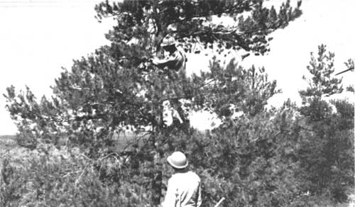
|
| Monument workers prune misletoe from limber pine, ca. 1962. (Photo courtesy Glenn Hinsdale) |
Forestry Versus Ecology
Where earlier superintendents had been content, it seems, to condone such a severe program, Superintendent Daniel Davis was not. Davis assumed office during the height of the eradication program, on April 14, 1963. He brought with him a background in both blister rust and mistletoe control projects from other parks; that experience helped cement his cynicism regarding eradication's success. When he arrived, he thought "what a disaster." Slash piles both burning and ready to burn confronted the visitor. [146] Between January 22 and March 23, 1964, Davis engaged in a point-by-point argument with Region Four staff over the mistletoe project, stressing the need for an ecological approach to management rather than manipulative policy.
Believing eradication to be overmanipulation of the resource, he recommended that "a moratorium on aggressive control work should be called until sufficient [ecological] research has been done to justify these drastic measures...." Davis calculated that given the logic of the program, the number of trees already cut, and the number infected the outcome could result in deforestation of the monument. The current forestry practices, Davis contended, simplified the matter by destroying the infected trees. From "an ecological standpoint it is very complex and few if any of the answers are known" regarding the long-term environmental effects of the tree removal program. An ecological approach would fulfill this need. The pines, it was thought, ranged from three hundred to fifteen hundred years in age, and they appeared to have lived with the mistletoe without serious damage for many decades at least, evidence which seemed to counter the justification for the eradication program. To Davis, the situation had reached a crisis point and demanded a new perspective. After all, he asked, "which generation should have preference--this one or one 500 years from now?" [147]
While lobbying to stop the program, Davis continued to oversee eradication of trees. He preferred poisoning (begun in 1963) to felling, which left the "appearance of Attila's wintering grounds." Visitors viewed the unsightly logging operation and the downed trees and slash piles. Burning killed sensitive vegetation on the cinder cones, and logging vehicles left permanent troughs on the slopes. As the lesser of two evils, poisoning left the land looking more natural; the dead trees whitened and appeared as if killed by lava flows. Snags cast a better image than stumps. [148]
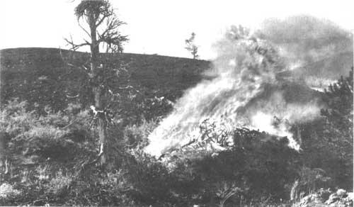
|
| As part of the Mistletoe Control Project, slash piles were burned, often in full view of visitors. (CRMO Museum Collection) |
In response to Davis' request for a moratorium and ecological research, Western Region defended its actions and went toe-to-toe with the superintendent over points of scientific knowledge and interpretation, and in doing so denied his request. Assistant Regional Director of Operations Keith Neilson told Davis that the regional office had carefully analyzed the situation. In general, policy came down to a question of activity versus inactivity. Without control measures, it was believed that possibly all rather than some of the trees would be lost. Elimination of infected mature trees would allow younger limber pines to thrive. In the language of the Leopold Report, the limber pine was part of the monument's "natural scene," and it was "the policy and responsibility of the Service to protect and insure the perpetuation of this important flora in at least the limited areas designated for control." [149] Therefore, biological manipulation would provide for the long-term as called for by Davis.
Assistant Director Neilson pointed out some discrepancies in Davis' data as a means to counter the superintendent's allegations. Neilson noted that the control area made up only one percent of the monument's acreage, thus lessening the impact of complete forest loss. He also inferred that Davis was rather naive to think that control measures were unnecessary. Even if the trees had lived with the parasite for one or two hundred years, the latest forest research recommended "some type of management or control." While the regional office agreed that Davis' call for ecological research was a sound suggestion, they foresaw no other approach to the issue. Regional specialists were at a loss to understand the superintendent's meaning of "ecological balance." Dwarf mistletoe might be part of the ecological process, contributing, for example, to the natural succession of a forest to sagebrush-grass ecosystem, but the parasite represented "an even more drastic alteration of the ecology than the control" program itself, something the agency could not condone. [150]
These points are significant not only because they support the denial of Davis' request for a moratorium, but also because they reveal how administrators lacked an understanding of the monument's resources, and how rifts in communication between the regional office and a distant park site influenced decisions. The regional office did arrange for Regional Forester Mahoney to go over the program in person with Davis during a site visit, yet Mahoney, for reasons both personal and professional, avoided encountering Davis on his scheduled inspection. [151]
Davis was ordered to complete the major phase of the program that year, and rather than contest the directive, he capitulated. However, he rejected the notion that he and his staff were less than professional in their concern. "[O]ur thinking is based on what we believe to be solid scientific foundation and not merely the maudlin bleating of a purist based on imaginary principles." Davis stressed that it was important for the regional office to understand that while the control area represented 1 percent of the monument's vegetation, it did represent about 95 percent "of the total vegetated area the visitor sees and uses." He also pointed out that region's plan to replace limber pine with Douglas fir in places where Douglas fir did not grow naturally would alter the monument's flora, perhaps even more than tree removal. These and other aspects of the plan, he maintained, demonstrated the program's lack of forethought and shortsightedness. His pessimism was born out of such distinctions. [152]
Although Davis was not successful in ending the mistletoe program, it was phased out several years after his departure in 1964. No new tree destruction occurred after 1963, for example, only follow-up maintenance and pruning. [153] Regional office officials, Acting Assistant Regional Director John G. Lewis and Forester John Mahoney, pronounced the program a success after separate inspections in 1965 and 1966, citing new tree growth as evidence. Although Mahoney recommended deferring more maintenance work until 1968, Superintendent Roger Contor resisted attempts to begin eradication practices again. Agreeing with Davis, and most superintendents since, Contor thought that the program was "totally stupid." And when drafting the 1966 resource management plan, the superintendent and his staff insisted "on wording that makes solid research a prerequisite to plant pest control." Monument personnel preferred language that said "diseases or plant pests which threaten major portions of the vegetative cover shall be controlled by methods which do not greatly effect [sic] other elements of the original scene." "We do frankly fear the all-too-common control of this-or-that forest pest which leaves a greater disturbance to the landscape than the pest itself." [154] In this case, the eradication program was the most glaring example, and its continuation was postponed indefinitely, pending an extended period of observation and research. [155]
In December 1967, Superintendent Paul Fritz reported that the Park Service was coming under increasing public scrutiny and criticism for its handling of the mistletoe program, and stated that the program's future would be decided by a current study. Biologist Karl Urban's report on the mistletoe problem at the monument, finished in 1968, demonstrated that eradication had failed to curtail the parasite, and that the trees had been infected more than two hundred years prior to the program. [156] These findings thus confirmed what Davis and others had maintained, that the limber pine were able to live with the mistletoe, and a long-range approach sensitive to ecological processes was the better way to manage the mistletoe infection. Following the report's publication, the program was scuttled.
In the end, Davis' worst fears of total deforestation never came to be. Limber pine have reseeded from the remaining trees, and small trees cover former stands. Nevertheless, ramifications of the project have cropped up as recent resource management concerns. Limber pine snags, the standing dead from the eradication program, present safety hazards, and thus constitute an important focus in the monument's hazard tree program initiated in 1987. The proposal to reintroduce porcupine is also tied directly to the health of the limber pine forest, which is a key habitat for the animal. And there is the potential for two exotic birds, the starling and the sparrow, both of which are currently uncommon, to be attracted to the cavities of the abundant snags for nesting, thus competing with native birds for shelter. [157] Understanding the full ramifications of the mistletoe program, however, may be difficult. It seems clear from Urban's research that an ecological approach would have left well enough alone with similar results. But because alteration occurred, that conclusion is difficult to prove. In the larger picture, mistletoe eradication represented one of the few cases of resource manipulation at the monument, coming at a time when the Park Service was only beginning to incorporate ecological principles into its management actions, and had yet to fully embrace them.
FIRE ECOLOGY AND MANAGEMENT
Fire's history and management at Craters of the Moon are not well documented. While fire is important for maintaining a healthy ecosystem, historically it was not considered in such a positive light. It can be assumed that monument fire policies have followed Park Service trends, beginning with suppression and culminating with allowable burning in recognition of natural processes, with more recent revisions prompted by the Yellowstone National Park fire in 1988.
Early Management
In the first decades of management, fire appeared as a largely insignificant issue at the monument. Most discussion centered on fire as a threat and the need to suppress it. In September 1940, for example, Associate Forester Jack B. Dodd noted that in the past fire posed few problems, but the potential for increased risk existed with increased visitation to the area once the highway was rerouted and paved through the area in 1941. The forester stated, though, that Craters of the Moon's main fire threat stemmed not from forest cover, as was common in most parks, but from ground vegetation composed of grasses and sagebrush on the lava terrain. Frequent high winds added to the fire danger. [158] Even at that, the vegetative cover was sparse and located in isolated islands separated by vast expanses of barren lava. These two factors made fire a minimal threat to the monument's resources, Regional Director O. A. Tomlinson reported in July 1943. The lava fields acted as a barrier reef protecting vegetation from fires, thus minimizing management concerns. [159] In the monument's more lush northern foothills, though, fire posed more concern, as with the Little Cottonwood Canyon fire in the fall of 1945. [160]
Cooperation in Fire Management
Although fire was not considered a great threat, Craters of the Moon and the Bureau of Land Management signed an informal cooperative fire-fighting agreement in October 1959. Reasons for this were due to the monument's remoteness, its a lack of personnel, and its location next to BLM lands. Initiated during Superintendent Floyd Henderson's tenure, the agreement appears to have formalized cooperation with fire suppression at the monument for several decades. The document called specifically for aid in detecting and reporting fires; it established a "Common Dependency Zone," an approximately one-mile-wide zone on either side of each agency's shared boundary. The two agencies agreed that the first available agency fire crew would respond to a fire in that zone at no charge for the initial fire-fighting period. After 10 a.m. of the day following the outbreak of the fire, if personnel were still required, then the agency whose land the fire was on would reimburse the other for that additional assistance. In the event of a fire on both Park Service and BLM lands, both agencies agreed to either mutually suppress the fire and compromise on costs, or suppress only that portion on their lands, and incur all costs. The agreement also provided for other logistical matters, and is currently in force. [161]
Natural Burning
In the 1966 resource management plan, Superintendent Roger Contor stated a new phase in fire management. Expressing the growing ecological emphasis of the 1960s and the NPS emphasis on "original conditions," Contor's fire policy emphasized the need to allow naturally caused fires to burn. Both the monument's vegetation and its value for ecological research would benefit. Fire was a main determinant in and "absolutely essential" to maintenance of "the mosaic of mixed successional stages in the ecological sere of any pristine area" like Craters of the Moon, Contor stated. The superintendent noted that the combined factors of the monument's sparse vegetation, mostly barren lava terrain, and grass islands within natural lava fire-breaks raised little possibility of fire danger to surrounding areas, to the highly visible areas of the monument, to the monument's man-made infrastructure, and to visitor safety. Such a fire program, however, would only be successful after educating the public and securing its approval for such actions. The plan also mentioned the possibility of using prescribed burning as an appropriate management tool, but more research was needed, and at the time, such a management practice did not appear necessary. As a general rule, remote or wilderness area fires would burn unchecked with some limitations; any threats to the aforementioned would require suppression. On the other hand, human-caused fires would be suppressed. For both the sake of the vegetation and the sensitive volcanic landscape, minimum-impact fire-fighting techniques must be followed at all times. All too often in the past, the "only damage ever caused by fires in Craters of the Moon" came from "bulldozers, roadgraders and other machinery used in non-existent emergencies." [162]
In reality, the superintendent concluded, this "will not change very much the fire behavior history of the area. Most of our infrequent fires flare up and die out independently of man's influences." In addition, this policy might "put us at peace with ecologists who correctly criticize our inconsistent policies which sometimes destroy, rather than perpetuate, the original scene." Properly presented, the role of fire in the monument could "impress upon the public" the Park Service's "very special mission" at Craters of the Moon. [163]
Wood Fire Ban
The next fire-related policy decision originated in 1974, when Superintendent Hentges decided to discontinue wood burning in the monument. Hentges did so because wood fires were fueled by the dominant tree at the monument, limber pine. Wilderness and auto campers fueled their fires with the trees scattered throughout the monument, and it was evident that this practice could lead to serious impacts. In the wilderness area, limber pines occurred less frequently than in the more developed northern section of the monument. Any depletion through wood gathering or inadvertent fire would diminish their "ghostly" presence and the wilderness experience.
In the campground area it was especially important to discontinue wood burning in order to protect the forty to fifty remaining live and dead pines left from mistletoe eradication in 1960s. The control program had concentrated in the monument's frontcountry, thinning the already sparse pines and making their protection all the more significant. Near the campground, the few remaining trees represented the only wood source, and no matter enforcement or regulations, visitors were slowly eliminating the standing pines as they stripped them for burning. In addition, many of those visitors who complied with regulations found wood along the loop drive for their fires. This latter practice promised only to spread the problem to other sites. [164]
Prior to receiving official authorization to ban wood fires, the monument employed a temporary solution during the 1975 season, permitting wood fires only in the campground, and only if visitors collected the wood from outside the monument's boundaries. Furthermore, plans called for removing any incentive for wood fires altogether by replacing the concrete fire pits with aluminum charcoal grills (completed in 1976). [165] It was felt that both human and natural environments would benefit from this change. At the end of the 1975 season, Superintendent Hentges submitted a draft of the wood fire ban regulation to the Pacific Northwest Regional Director Russell E. Dickenson, who approved the measure on March 1, 1976. In its final format, the regulation called for a ban of wood fires within the monument, except for the north unit group campground (the draft regulation provided for fire at the amphitheater). There the monument would supply wood imported from outside the area for campfires. [166] Even though the monument enforced restrictions on wood fires within the monument beginning in 1976, Acting Superintendent Neil King reported in February 1982 that the regulation had never been published in the Federal Register or appended to the CFR as required by Park Service policy. Thus the regulation, still not codified, has been enforced through voluntary compliance only. [167]
Fire Ecology in the 1980s
In 1980 Superintendent Hentges and his staff turned again to fire and its ecological role in sound resource management operations. Although the 1966 resource management plan stressed the importance of fire, no subsequent research had followed to form the basis of a fire ecology plan. The fire management plan, drafted that year, did not cover any "prescribed conditions for natural burns" and called for fire suppression throughout the monument as the general rule. [168] A year later, Hentges informed Pacific Northwest Regional Director Daniel J. Tobin, Jr. that the monument's wildfire management plan was "proposing prescription burning within the wilderness area." In order to win approval of its wildfire policy, the monument took steps to establish prescription burning guidelines in 1981 through research conducted by the Cooperative Park Studies Unit at Oregon State University. [169] The research was never conducted and the advances in the wildfire program went unmet.
The 1982 resource management plan underscored management deficiencies caused by total fire suppression, noted the possible benefits of natural fires for vegetation, and emphasized the fact that "little is known about the role of natural wildfire on the various plant communities of the monument." Once the role of natural fire was determined the monument could best manage its flora and fauna. Finally, full suppression in the remote districts of the monument was not economically sufficient. Management boiled down to a question of ecological stability and economic feasible. The 1982 plan suggested a reformed program of fire ecology, one in which ecological principles and financial costs were key components, as was the desire to emulate and to be compatible with the "fine program" of natural-prescribed burns practiced by the surrounding land owner, the BLM. The main purpose was to create an allowable burn program by researching the fire history and fire ecology in the monument. This would establish the most comprehensive ecological management for the monument's flora and fauna. [170]
The fire ecology program at Craters of the Moon has developed slowly. After an October 1985 fire on BLM land, the monument signed a memorandum of understanding to establish vegetation plots on the burned lands to collect fire ecology data. [171] In 1988 a wildfire ecology study was initiated by the University of Idaho's Cooperative Park Studies Unit. [172] Completed in 1990, the study of both the fire history and ecology at the monument revealed substantial evidence of natural fires at Craters of the Moon in nearly all vegetation types. Reflective of the 1966 observations of Superintendent Contor and his staff, the study concluded that the majority of the monument's vegetation (except for the northern unit) was distributed throughout isolated pockets of lava flows, and that fuel buildups were low. For these reasons, the study recommended that prescribed natural fires be included in the monument's fire management plan; to that end, the document also furnished parameters as a departure point for a prescribed natural fire program, as well as data to be incorporated into the existing plan. [173] With this information and the NPS policy fire policy revisions following the Yellowstone fires, the monument could finally see fire's role in resource management.
CAREY KIPUKA
Added by presidential proclamation on November 12, 1962, the Carey Kipuka is an island of relatively pristine grass surrounded by raw, unvegetated lava. Given these physical conditions, the grassland is fairly well protected from impacts from livestock grazing, and provides an isolated area for ecological research, namely in the form of vegetation and soils studies. The kipuka also offers visitors a better understanding of the different components of the Great Rift, and guarantees the permanent protection of a feature unique to a volcanic environment.
Fraudulent Addition?
The kipuka's management lacks the protracted struggles over trespass grazing plaguing the monument's northern unit, yet the site's addition and management was predicated on the fact that the kipuka contained "pristine" grasslands. Managers learned later that this was not the case and this raised the question of the kipuka's value. [174]
In the late 1950s proponents of the kipuka addition believed that its protection would be an asset to science, since undisturbed grasslands were rare in the West. One of the selling points of the Carey Kipuka was that it possessed nearly "pristine" vegetation. It was remote, dry, and surrounded by jagged lavas, and seemed impervious to livestock grazing and any kind of "unnatural" biological change. Ecologists F.R. Fosberg and E.W. Tisdale, among other scientists and observers, were aware that calling the kipuka "pristine" was an oversimplification fashioned for the sake of legislation. They admitted that some type of disturbance had occurred through wildlife and Native American activities. They identified, for example, a well-worn and marked Indian trail leading to the grass island. Nevertheless, its value as a research tool was immeasurable compared to more altered sites in the region. [175]
As it was presented for legislation, then, the Carey Kipuka's pristine condition created some ambiguity for monument managers who discovered upon closer inspection that it was indeed disturbed by man and livestock. Visiting the area in the early 1960s, for example, Superintendent Daniel Davis found an obvious trail leading into the site and sheep bones in the grass. His successor, Roger Contor, similarly saw a grassland laced with stock trails, evidence of sheepherder camps strewn about, sheep crossing the lava flows surrounding the kipuka, and even his horse run across the rough terrain. To Contor all of this evidence challenged the integrity of the kipuka and made it a fraudulent addition to the monument. In a sense, the Park Service had lied to Congress, yet for political reasons he decided that it was best not to raise any objections. Precedence was at stake. But in another sense, Contor and other superintendents had to reconcile how the kipuka was presented in the language of the legislation with its value to science. For in a larger perspective, kipukas in the near pristine condition of Carey Kipuka were quite rare. And because of its protective status, the kipuka's value can only grow. In the late 1980s, the Carey Kipuka was nominated for national natural landmark status. [176]
WILDLIFE MANAGEMENT
Contrary to the observations of 19th-century explorers and emigrants, Craters of the Moon's volcanic environment supports a variety of wildlife. Nearly fifty types of mammals and more than one 140 bird species make their homes at the monument. Wildlife management has followed Park Service trends, evolving from manipulation to a more informed understanding of natural processes. Without the predators and therefore the traditional problems of predator control inherent to the bigger parks, Craters of the Moon managers have engaged in little direct manipulation of native animals. Protection programs instead have focused on preventing poaching of the monument's high-profile mule deer herd. Because of its visibility and attraction to both hunters and visitors, the herd has been the predominant wildlife management concern; its protection encompasses issues involving revision of northern boundary, law enforcement, research, and cooperation with other local and federal agencies. Another less volatile wildlife issue pertains to the reintroduction of two extirpated species, one known historically to have existed in the monument, big horn sheep, and the other known to have been actively eliminated by early managers, porcupine. [177]
THE DEVELOPING PROGRAM
As with other phases of the monument's management, wildlife management was largely an unorganized enterprise until the 1950s. [178] While hunting is prohibited at Craters of the Moon, deer poaching has occurred with frequent regularity and has occupied administrative time and energy since the monument's establishment. A central contributing factor has been the northern boundary which follows a grid rather than a topographical pattern along the hydrographic divide. The boundary's "unnatural" location often confuses hunters outside the monument who accidentally cross into and kill an animal on Park Service land. For those less respectful, the vagaries of the boundary provide a good excuse. [179] Besides the boundary problem is the attraction of the well-sized deer themselves. Compounding the problem further is the herd's seasonal migration to the monument's northern unit (with its relatively lush vegetation and water) where it finds sanctuary during the fall hunting season as pressure on outside lands increases. Although early managers displayed concern for other species, sporadically inventorying animals within the monument boundaries as funding and staffing allowed, they concentrated primarily on preserving the deer herd--patrolling the boundary of the northern unit to inform hunters of Park Service regulations. In doing so, they mostly offered visual deterrence.
A Program in Disrepair
During the war years, even this minimal level of wildlife management decreased. In the fall of 1945, both the director of Region Four and the Washington office believed that the monument's attention to wildlife resources was falling short of Service policy. Regional Director O.A. Tomlinson was unsatisfied with Custodian Guy E. McCarty's October wildlife report, which stated that in 1945 "work in the field of wildlife at this area...consisted of patrol during hunting season, and putting out salt for the deer." [180] Tomlinson objected to the cursory nature of the McCarty's program, as did NPS Acting Director Hillory Tolson. Salting for deer also raised substantial concern. Not only did it run contrary to Service policy, it also introduced abnormalities, concentrating animals in specific areas and resulting in landscape disturbance due to salting and overgrazing. Tolson recommended that McCarty desist from salting, and Tomlinson admonished the custodian for not putting more effort into his duties. [181]
While the directors may have been correct in their assertions regarding Service wildlife policy, the war years had left the monument's administration threadbare. McCarty was the lone permanent employee assisted only by fluctuating seasonal staff who were usually terminated by fall hunting season. Moreover, the war era and gas rationing increased local pressure on the monument's herd. Until restrictions were lifted after the World War II, hunters were unable to range far from home. [182] While the custodian's single-sentence report of October 1945 suggested apathetic management, his wildlife reports did include a significant roster of fauna.
Law Enforcement, Cooperation, and Research
Typifying wildlife problems at the monument, McCarty discovered in November 1946 that many "hunters were receiving information, from around Twin Falls and vicinity, [sic] that the area north of the highway was open to hunting. This required continuous patrol to head them off before they got started." [183] Working in cooperation with the state game warden and county sheriff, the custodian helped arrest two hunters, who were fined in Arco approximately one hundred dollars. [184] It appears that this event represented the first reported law enforcement action at the monument involving wildlife. More importantly, perhaps, is that it signifies roots of cooperation between local and state law enforcement agencies and monument personnel in controlling illegal hunting.
It is known, for example, that Custodian McCarty participated in area law enforcement as a substitute Butte County Sheriff in September 1946, [185] and it is likely that he operated in the capacity of Idaho Deputy Sheriff and Game Conservation Officer, as authorized by a May 26, 1943 memorandum from the Department of the Interior. [186] His successor, Superintendent Aubrey Houston, did become deputized under that directive in October 1951, launching a long-term trend of active and cooperative law enforcement toward poaching. [187]
The policy of seeking law enforcement credentials and cooperation to combat poaching lacked in application what it gained in principle. The monument's small staff was simply unable to keep pace with increasing threats. During the early 1950s, local population grew with the installation of the Atomic Energy Commission's facility in the Lost River Valley, which in turn expanded hunting pressures on wildlife (primarily mule deer) near and in the monument. While day and night patrols in 1951, for example, netted some illegal hunters, others went undetected or unprosecuted. Reflecting on the 1951 season, Superintendent Houston cited the standard pre-Mission 66 analysis of the monument's administration: "Lack of adequate personnel made it possible for poachers to kill four deer during the last hunting season." Other outside pressures tended to exacerbate management problems as well. The classification change from "special hunt" to "open country" in the adjacent Lost River Range, for example, caused the herd to incur greater stress as hunting blanketed the region for the extent of the season rather than being limited to specific places and periods. But no matter the season, closed or open, Houston concluded, poaching remains a problem, "and frequent patrols are needed to meet this threat." [188]
Even the addition of the monument's first permanent ranger (in spring of 1952), frequent patrols and roadblocks in the hill country near the northern unit did not appreciably end violations by the late 1950s. This led to another cooperative effort: Park Service officials and Idaho Fish and Game Department officers marked the boundary of the northern unit together, posting hunting closure signs on September 29, 1959. [189] The 1960s saw more of the same--night patrols tried to deter spotlighting, and boundary surveys of the Little Cottonwood drainage distinguished Bureau of Land Management lands from those of the Park Service. But more policy changes were required.
Turning to the law, in a February 1964 report, Superintendent Daniel Davis signaled the need for better state and federal law enforcement regulations in protection of the monument's wildlife, especially the deer herd. To that end, Davis contacted the Idaho State Fish and Game Commission "in hopes of getting state hunting regulations pertinent to Craters of the Moon changed to more closely coincide with federal regulations." The loophole at the time stemmed from the fact that while the monument was classed a "`closed area' for hunting it is not a state offense to carry a loaded gun or shoot on the monument as long as a game animal is not killed." As an example, coyotes or mountain lions "could legally be killed as far as the state is concerned." Enforcement was also exacerbated by the monument's distance from the nearest federal magistrate, located several hours from Craters of the Moon, and consuming precious time for a small staff to seek a conviction. [190]
Although the outcome of Davis' attempts to upgrade the monument's wildlife management program is not known, a significant policy highlight took place the following year. In the summer of 1965, Superintendent Roger Contor drafted the Long Range Wildlife Management Plan for Craters of the Moon National Monument. Approved August 16, 1965, the document stated that previous management activities "have been negligible." Rather than highlight legal deficiencies as had his predecessors, Contor instead stressed research as the primary management tool. Objectives of the plan were oriented towards all wildlife in order "to maintain and, where practical, re-establish representative populations of native wildlife and plant communities in a healthy ecological environment which provides each species a reasonable opportunity to perpetuate itself." [191] Expressing the philosophy of "original conditions," as called for in the Leopold Report, the management program would attempt to better understand wildlife, such as deer, through research, and base management directions on relevant and contemporary wildlife studies. In addition, it was determined that the monument's small size was not conducive to harboring predatory animals year round; controls in the grazing country outside the monument thinned the number of predators to the extent that predator management was largely unnecessary. [192]
While the focus was on all of the monument's animals, once more the popular deer herd drew the most attention. Vegetation and population studies were needed to determine range carrying capacity and composition, as well as the growth rate of the herd, which appeared to be on the increase since the area's establishment. Visual observations suggested that vegetation was suffering impacts from deer browsing--a concern on record since the mid-1950s. [193] And only after proper investigation, then, could resource managers determine appropriate controls. Were reduction required, for instance, Contor decided that public hunting, ironically, would prove beneficial. If necessary, monument and state wildlife personnel could even haze the deer out of the boundaries during hunting season for several days. [194]
Superintendent Contor's recommendations and attempts to initiate wildlife research met with success after his departure. [195] Between April 1967 and January 1968, the first mule deer study was conducted by Brent Ritchie, a seasonal ranger and graduate student in wildlife biology, who carried out his research on his own time. Ritchie's research focused on the population, migratory characteristics, and life cycles of the herd. Ritchie also established permanent range transects to monitor forage growth and use. At most, the study led to a more informed observational management program, from which, it was hoped, more substantial management programs could emerge for "herd and range use controls." [196]
Evidently this type of research satisfied management concerns at the time about the herd's life history and interaction with the surrounding environment. In the late 1960s and early 1970s, population and range issues were all but absent from issues surrounding the herd, and illegal hunting still constituted the greatest threat. For Superintendent Paul Fritz, the best program for mitigating hunting impacts reflected standard policy practiced by the first monument managers--patrol. But to this he added a higher level of public contact, informing both the hunters and the community at large of Park Service regulations and the monument's mission. [197] Good public relations alone, however, failed to curtail violations to a satisfactory level. As stated in the monument's 1972 annual report, enforcement required more legal punch. "A bail-bond system would help mete out justice and could serve as a deterrent to further poaching." [198] The state passed a bail-bond system two years later, and monument personnel welcomed the new measure. [199]
New measure or not, when Robert Hentges assumed the superintendency at the monument in 1974, he and his staff pursued a stricter protection program. Like other managers before him, Hentges upscaled patrols, and completed a northern unit boundary marking program in 1977. [200]
Although he reported early success from this program, Hentges also noted that illegal hunting continued to be influenced by forces beyond the monument's immediate jurisdiction. Hentges remarked that poaching correlated with Idaho's fluctuating hunting regulations. A general opening date for the hunting season, as was the case in the late 1970s, for example, caused less pressure on the monument's deer herd because hunters were dispersed throughout the state--all at one time. Separate openings, on the other hand, staggered the hunting season, and, as Hentges recalled, attracted more hunters to the monument who were looking to bag an "extra" deer before hunting one legally elsewhere. [201]
To counter poaching, Hentges broke with traditional policies and went one step further. His roadblocking and spiking program presents the best example of his quest for wildlife protection. Accessibility constituted a great threat to the herd. When Hentges arrived, poachers were driving onto the north unit on the old road bed of Goodale's Cutoff. To combat illegal entrance from the west, the superintendent stacked rocks and posted more warning signs. Even so, Hentges recalled, determined hunters detoured around them. He executed his most extreme deterrent near the eastern entrance. He ran a cable gate up the hillside closing access to the road. Here, too, he spread signs out along the ridgeline and unused two-track roads warning trespassers of unlawful entrance. It was along these old roads that Hentges buried long, metal spikes mounted in boards. Instead of a hunter, though, the spikes trapped a rancher, who, without heeding orders to contact a ranger first, attempted to retrieve his cattle from within the northern unit. The act took place at night; the violator lost all four tires, confronted the superintendent with the spikes the next day, and took his case to the sheriff. While Hentges believed he was right, he removed the remaining spikes at the sheriff's request--to avoid public controversy and respect the state's jurisdiction at the monument. But, as Hentges recalled, "word got around, and I never saw another track in the park around our gates." While this might have been an overstatement, the incident indeed proved to be an effective "rumor" for reducing the number of poachers operating out of vehicles, leaving rangers more time to pursue those hunters who entered on horseback or foot. [202]
In the late 1970s, additional personnel also aided in the resource management program and in protection of the mule deer herd. When Chief Ranger Neil King joined the staff at Craters of the Moon in 1978, he replaced a ranger who had not been very effective. [203] King helped establish regular patrols and a formal program of hunter contacts--giving hunters printed handouts of monument regulations outside the boundary. But more significantly, King used his law enforcement knowledge and experience (reflecting the systemwide trend to commission law enforcement rangers) to work with local and state agencies to rectify the poaching issue.
In the meantime, other steps taken to improve herd management involved more research. It was one thing to concentrate on poaching, but while the herd "provided meat and trophies for those outside the boundaries," it had high significance for the monument visitor, according to Hentges. The herd's north to south migrations through the monument provided excitement "for the park visitor who drives the loop drive road in the early morning light....This herd is a major resource at the park and needs to be studied more thoroughly in order to be managed properly in the future." [204]
To this end, the National Park Service and the Cooperative Park Studies Unit at the University of Idaho funded a three-year study in May 1980 to investigate the life cycles and characteristics of the herd. The study, conducted by wildlife biologist Brad Griffith, helped answer questions about the herd's population; Griffith determined that hunting provided a major population control (contrary to past beliefs that dispersal was the reason) as did natural mortality, and to a lesser extent highway accidents. In addition, findings confirmed the north-south migratory pattern, and also proved that the herd dispersed over the monument's entire vegetated range. Finally, Griffith countered previous conclusions that the herd damaged its forage supply. [205]
In terms of management, Griffith recommended ten guidelines for monitoring the herd's population and habitat. Included in these were methods to acquire estimates on herd population size, productivity, and winter survival of fawns. Hentges, while pleased with the report overall, expressed some embarrassment over the recommendations. The monument was unable to review the document prior to publication and had concerns with some of its conclusions; this caused managers, in some instances, to apparently contradict their own policies during consultations with state and federal cooperating agencies familiar with the report.
Hentges called attention to two recommendations in particular that posed problems. The first was the suggestion to develop and implement a prescription burning program for the northern unit, a debatable idea. Other factors besides the deer herd, such as public opinion, planning, and Park Service policy, were involved in this type of policy and further study would be necessary. The second recommendation concerned reduction in road kills during heavy visitation in August and September. Deer were attracted to the visitor center lawns and sprinkling system across the highway from the northern unit, and the report advised that both be removed and be replaced with native vegetation. On this point, Hentges stated that "Visitor use patterns, grounds, maintenance," to name a few things "all must be considered [first]. To phase out the entire lawn system is not acceptable to park management." [206]
Moreover, the study helped implement two standard operating procedures in the monument's resource management program. Beginning in 1983, population and vegetation monitoring were incorporated into the herd's management. [207] The study also provided the basis for entering into a long-term cooperative agreement with the Idaho Department of Fish and Game. The agreement had been a goal of the research program because the monument is but one agency managing the herd, [208] which migrates through Craters of the Moon. Approved on September 14, 1984, the Memorandum of Understanding Between the Idaho Department Fish and Game and the National Park Service provided for management of the mule deer herd "in recognition of the need for cooperation in the preservation, use and management of wildlife within the Craters of the Moon National Monument and upon adjacent and State lands." [209]
The memorandum crowned a four-year effort, brought about mostly by Chief Ranger Neil King in 1979, who believed that law enforcement was one of the best methods for protecting the herd. Because of the monument's proprietary jurisdiction, the National Park Service possesses only regulatory authority at the monument, whereas the state "has the legal obligation and authority to enforce criminal law in the park." [210] State authority was requisite to properly manage the herd, and impossible without a written agreement. Generally, the agreement allowed monument rangers to enforce state laws and formalized the practice of deputizing rangers as conservation officers. Thus, not only could rangers enforce state regulations inside the monument, but they could also assist state officials outside the area's boundaries. No longer were rangers helpless to stop activities occurring just outside monument borders. Now they were able to issue citations and successfully prosecute cases. The program under the agreement, related Superintendent Hentges, will place the park
in a position to effectively meet our management objects of...maintaining solid data on the deer population that will be accepted by the other cooperating resource management agencies...provide maximum protection for the deer herd while maintaining good relations with hunters along the monument boundaries...more effectively control poaching/illegal killing of deer and...prosecute poachers in the most efficient and cost effective manner. [211]
And for the Department of Fish and Game, the agreement permitted the agency to better fulfill its legal obligations at the monument, while at the same time concentrate its efforts elsewhere. [212] Lasting for a period of five years, the document was reaffirmed on October 26, 1989.
In a historical context, the 1984 memorandum represents a significant wildlife management landmark. While the effort to formalize the cooperation between agencies lasted four years, the process transpired over a longer period of time. Monument officials since at least the 1940s collaborated with state game wardens to protect the monument's wildlife. The agreement also helped to institute active law enforcement, patrols, monitoring, and interagency cooperation as the basis for mule deer management.
In 1987, Superintendent Robert Scott announced successes in herd management. For example, cooperation among the United States Fish and Wildlife Service, Idaho Fish and Game, and the monument resulted in the arrest and conviction of individuals involved in three separate poaching operations outside the area's boundaries. More significantly, perhaps for the first time, no known poaching occurred within the monument. [213] Even so, several citations are issued each season, in or near the monument, for illegal hunting. To date, no real changes are foreseen in managing the herd. [214]
REINTRODUCTION OF EXTIRPATED SPECIES
Several extirpated species have been known to exist within or near the monument, mostly prior to the area's establishment. These were grizzly bear, bison, bighorn sheep, wolves, beaver, and porcupine. Of these only the porcupine lived within the monument at the time of establishment, and was the only animal actively exterminated by the Park Service. Predator control never surfaced as a necessary management issue, and for the most part manipulation of the wildlife population appears to have been minimal. In accordance with Park Service wildlife management trends, however, the reintroduction of certain species has been considered.
Beginning on August 24, 1951, the Park Service expressed an interest in starting a wildlife restoration program at the monument. Earlier attempts, it seems, were delayed by shortages of funding and personnel. In the meantime, the regional office relied on the expertise of monument managers experienced in wildlife research to make up for its lack of assistance. [215]
While no other documentation exists to confirm any restoration activity in the early 1950s, some things about the program's direction are clear. The favored species were not bison, bears, or wolves. Managers considered it impractical to relocate these types of animals within the confines of the small monument and expect them to survive, let alone not interfere with adjacent livestock, threaten humans, or disturb the volcanic features. [216] On the other hand, beaver and bighorn sheep were more popular choices.
On September 1, 1959, Superintendent Floyd Henderson informed the director of Region Four that he was considering the restoration of bighorn sheep and beaver. Conditions seemed favorable to reintroducing these two species at the monument. Henderson cited the discovery of old ram horns in and near the monument as well as the testimony of older residents as to the validity of former bighorn populations in the Craters area. Beaver-cut trees in the drainages of the northern foothills indicated that beavers had also recently inhabited the monument. Good grazing plant species and browse existed within the monument and while the deer herd browsed the vegetated terrain in the north unit, its use changed seasonally. No overgrazing was evident, and Henderson predicted that the bighorn would thrive and neither stress the area's range nor threaten the herd.
As for beaver, Little Cottonwood Creek presented the ideal place for reintroduction. It supported a variety of trees and brush--aspen, alder, willows, and chokecherry--as well as an abundant water supply. All told, several beaver colonies could live in this drainage. Henderson justified bringing beaver back into the monument, stating that other drainages in the vicinity were home to "small beaver populations, whose dams hold back freshets, permitting the streams to run during the drier months." The species would not interfere with the monument's administrative supply, situated above treeline and sustainable beaver habitat. Flooding would pose no problems for roads, and would in fact form ponds the monument could use for suppressing fires. [217]
In response, Region Four solicited Field Research Biologist Adolph Murie to analyze the feasibility of the Henderson's proposal. Murie, after visiting the monument in the fall of 1959, concluded that reintroduction was ecologically impractical. The monument was simply too small to support the proposed introductions. Murie agreed with Henderson that the native vegetation of grass, sage and bitterbrush could support sheep as well as mule deer, but only if the sheep numbers were few. Furthermore, containing the sheep within the monument posed another problem, since the species migrated to higher ground. Therefore even if the sheep remained within the boundaries, the "ecological relationships would be cramped and artificial and would probably require detailed management. They would tend to be a showpiece rather than part of a satisfactory ecological situation." Reintroduction of beaver posed similar ecological problems. Certainly, habitat existed in the mile-long stream drainage, but the food sources were limited. Murie noted that willow would likely increase with beaver ponds, but that other sources would be "sacrificed" in the process. In all, he recommended against reintroduction, because the beavers would most likely "eliminate their food supply." In both cases, Murie suggested that the monument instead concentrate on the significance of its flora. In the West, where overgrazing predominated, "it is especially pleasing to observe the flourishing bitterbrush and other species growing in the monument." Thus the monument's vegetation was better left "growing under current conditions." [218]
Based on Murie's conclusions that reintroduction would cause "cramped and artificial ecological relationships and the destruction of the limited amounts of available forage," Regional Director Lawrence C. Merriam turned down Henderson's proposed reintroduction program on October 19, 1959. [219]
Reintroduction resurfaced again, however, in the mid-1960s. Following the Park Service emphasis on wildlife management restoring the frontier scene, Superintendent Roger Contor, in both his 1965 wildlife management plan and his 1966 resource management plan, recommended introducing and encouraging several mountain prairie mammals. The wildlife program, for instance, recognized the possibility for the natural reintroduction of pronghorn and wapiti in the monument. Their migrations into or near the monument had been observed for the last half decade, and policy recommended cooperating with State Fish and Game officials "to guard against the erection of barriers to this migration." Managers foresaw no range problems since animals' migration through the monument would be short. [220]
By far the most effort went into the reestablishment of bighorn sheep. Contor, a trained wildlife biologist, favored reintroduction. Neither the management plans mention Henderson's previous attempts in this direction, and most likely, the recent change in Park Service resource management policies superseded prior decisions. Justification for bringing back sheep, however, echoed Henderson's 1959 proposal. The historic scene of the late 19th and early 20th centuries, for example, included bighorns in the Craters of the Moon region. Yet by the time of the monument's establishment, the bighorn sheep's sensitivity to livestock diseases wiped out the resident populations. Marshalling evidence Henderson had not, Contor noted that Robert Limbert's 1924 National Geographic article mentioned bighorn remains in the southern area of the Great Rift. Furthermore, in 1949 the last known sighting of a bighorn sheep occurred three miles from the monument. And in May 1965, a weathered ram's horn was uncovered on Sunset Cone. Contor also conjectured that depressions retained in cinder cones and the presence of Indian rock hunting blinds near waterholes suggested that either bighorns or mule deer were present and hunted within the monument during the dry summer season. [221]
Unlike Henderson's proposal, which seemed to concentrate on the northern unit as home for the animals, Contor proposed restocking sheep in the then-named Tutimaba Wilderness. [222] The wilderness provided the ideal habitat for the species--precipitous terrain, isolation, and sufficient water and forage. As before the only competition came from mule deer. After succeeding in the southern section, officials could distribute the bighorns to other sections of the monument. Contor cited federal agency and Park Service planting efforts as providing the necessary criteria for the project, and had approached several agencies about acquiring a nucleus herd.
With the approval of the wildlife management plan in August 1965, the Park Service endorsed the reintroduction program. The regional office was pleased with Contor's management plan and highlighted its reintroduction program. In the spirit of the times, Acting Assistant Director John Lewis exclaimed, "Your efforts when implemented will unquestionably restore to the greatest extent possible the early frontier scene." [223]
Contor pursued the program following approval of his management plan, broaching the subject with John Woodworth, director of the Idaho Department of Fish and Game on September 24, 1965; any reintroduction would involve Woodworth's department either directly or indirectly. The state bureau's only recommendation was that the Park Service assess the possible impacts bighorn sheep would have on the monument's deer herd. According to Brent Ritchie's 1968 study, the monument's vegetation in the central and southern sections was in near-pristine condition. [224] Because of this, Fish and Game research biologist James Morgan, who was in the process of initiating Idaho's first bighorn transplant in the Pahsimeroi drainage, suggested reintroducing sheep at the monument. Poor range conditions throughout Idaho were contributing to the bighorn's rapid decline. And if the monument proved to be a suitable habitat, reintroduction would help "to perpetuate a rare and beautiful animal...." [225] Superintendent Paul Fritz welcomed Morgan's proposal and consulted regional office specialists in April 1969, but unfortunately available records reveal nothing else on the matter, and presumably the reintroduction program was scrapped for the same reasons presented in 1959.
Yet the subject of reintroduction surfaced again in the 1980s. On July 25, 1983, research biologist Brad Griffith, while working on his study of the mule herd, notified Superintendent Hentges that transplanting sheep was still an unlikely proposition. Griffith put forth two reasons. First, like Murie, Griffith cited that the migratory nature of bighorns for winter habitat was incompatible with the small monument. A planted herd might not return, and fencing would prove costly. Second, the greatest obstacle stemmed from susceptibility to livestock diseases. The porous boundary and adjacent grazing lands, as well as the bighorn sheep's social behavior and migration habits all but ensured disease contraction, transmission, and the mortality of the reintroduced herd. [226] Heeding this advice, the monument decided against reintroduction; both the Fish and Game Department and the Bureau of Land Management concurred. As the 1983 resource management plan stated, from a conceptual standpoint reintroduction was favorable, but from a scientific and common-sense view, it was not. It would be too expensive and cause too much resource manipulation--for example, by adding stress on the mule deer herd--and ultimately fail. [227] Ironically, while no policy change has arisen since 1983, one bighorn ewe entered the monument and was sighted in Devil's Orchard on July 12, 1990. [228]
While bighorn sheep may never grace the monument's landscape again, porcupines might. At one time these animals were common at Craters of the Moon, yet their feeding habits threatened the monument's "scarce" trees. Believing that trees such as the limber pine deserved the "utmost protection," Assistant Director Horace Albright declared the porcupine a "predatory animal" and recommended that "instructions be issued to the custodian of the Monument to kill these animals on sight." Thus during the late 1920s and early 1930s, custodians routinely killed porcupines. [229] Their extermination reflected the "good versus bad" wildlife management policy practiced by the Park Service early in its history. In this case, trees in the apparently barren landscape were the favored biological species. Another contributing factor to porcupine demise most likely originated with mistletoe eradication conducted in the early 1960s. More than six thousand limber pine were destroyed, and along with them some important porcupine habitat. As the most recent resource management plan states, these anthropogenic activities were probably the cause of the porcupine's decline. Whereas wildlife reports from the 1940s and early 1950s document small numbers of porcupines within the monument (or evidence of them), the last porcupine was sighted in the monument in 1980; the wildlife baseline inventory conducted in the early 1980s recorded none.
The rationale to reintroduce the porcupines stemmed from the recommendations of this baseline survey. Furthermore, wildlife management philosophies have changed since the first custodians destroyed these animals. The limber pines, once at a critical stage, have shown an increase since the 1960s' program. Except for the pines, the rest of the porcupines' habitat has remained intact. That they are found near the monument further supports their reintroduction. With more research, the Park Service planned to pursue porcupine reintroduction in the early 1990s, and should this occur, it would be the first corrective program in wildlife management undertaken at Craters of the Moon.
WATER RESOURCES
Craters of the Moon's desert environment makes water scarce. Aridity characterizes the landscape, and management focuses on protecting the scattered water sources--perennial cave ice, snow, and waterholes--that occur naturally throughout the volcanic terrain. Providing water for visitors and the monument's administration forms another concern.
ICE AND WATERHOLES
The random appearance of water, snow, and ice in lava depressions throughout the monument provides a unique contrast to the otherwise dry and hot environment most visitors encounter in the summer season. Winter snow deposits collect in lava crevices, such as spatter cones, and the formations' insulating qualities cause the snow to last all year in places. Ice forms in caves. Some of this frozen water, it is thought, creates surface and subsurface pools. And all forms of water are valuable not only for human appreciation but also for wildlife. Most of the monument's wildlife cluster around these sporadic sources.
To date, management of these water resources has not followed any strict policy guidelines other than NPS protection mandates. The critical management concern has arisen over their disappearance. Up until 1927, the waterholes supplied visitors and managers, but after 1927, water vanished from this supply; most of the well known holes went dry (Registration, Doves, Big Sink and Yellow Jacket). As late as the mid-1960s, others such as Round Knoll appeared to be at a low ebb. [230]
In his 1966 resource management plan, Superintendent Roger Contor suggested a more active management position regarding the waterholes. It was necessary to prevent human and livestock consumption and impact from contaminating the waterholes and contributing to their further decline. Protection of the resource and human health was imperative. The plan recommended that a specific regulation prohibiting use was a possible means of management, yet it was never pursued because federal regulations satisfied this need. Furthermore, like caves the remote location of many of the waterholes served to protect them. [231]
Research has been the preferred mode of management. As Roger Contor noted, the greatest threat to the waterholes was the unknown. Yet while monument managers awaited sufficient studies, management decisions have been in response to resource disturbance, based on observations rather than solid research. The most significant among these dates to Superintendent Hentges' late-1970s decision to rehabilitate the spatter cone chain due, in part, to the disappearance of snow in the vents. The accumulation of rock and other debris thrown by visitors had raised the base level of the features, and snow, exposed to higher temperatures and sunlight, melted sooner and rarely lasted as long as in the past. [232]
Except for historical documentation from the 1920s and 1930s furnished by early custodians concerned over the decreasing level of the water pools, no other hard evidence exists regarding water quality and the source of water for springs and waterholes, or for the Snake River Plain Aquifer, running beneath the monument. To rectify this, the monument began studies in 1992 to assess the chemical and physical properties of the surface water, ice caves, and groundwater in the monument. [233]
ADMINISTRATIVE SUPPLY
In addition to the waterholes, the administrative water supply is critical to the management of the monument. Since the 1927 water loss, the Park Service worked hard to develop an adequate water supply for the monument. As a result, the monument was expanded in 1928 to include the foothills of the Pioneer Mountains and the watershed of the Little Cottonwood Creek drainage. And a water system was completed in 1931 tapping the surface water of the four springs at the creek's headwaters. It was hoped that the system would provide the monument an adequate supply, and management since then has sought to protect the springs and watershed from impacts such as livestock trespass. Thus, the present concerns with the water supply are to maintain water quality and supply. Contamination, drought, and increased demand present the greatest management challenges and over time have instigated the most policy decisions.
Following the water system's development, a wire cyclone fence was constructed by the Civilian Conservation Corps to enclose the springs in December 1938. [234] The impetus behind the project was the livestock use of the northern region, even though the new grazing policy regulated this activity. Due to the nature of the terrain, snow conditions, and fence material, the fence did not last long, collapsing under the weight of drifting snow. [235]
The absence of suitable protection for the supply raised concerns about surface contamination in the early 1940s. At that time a health inspection determined that spring number four was too contaminated to use; unlike the other springs, this one was located at the bottom of the draw and collected runoff, causing the water to be muddy. The spring was abandoned in April 1948. [236] Officials did not determine the cause of contamination; livestock impact, while a concern, was not a proven source. Periodically, Craters of the Moon managers attempted to rehabilitate the contaminated spring. In 1959 and 1960, for example, Superintendent Floyd Henderson's administration attempted corrective measures that failed to remove contamination from surface runoff. [237] Continuous treatment was the only solution, and the monument achieved this result with the rehabilitation of the water system in June 1960 as part of the Mission 66 program, at which time the spring was tapped once more.
Solutions for water quality problems were interwoven with solutions for livestock trespass in the northern unit. In this regard, Superintendent Everett Bright in his 1956 Mission 66 prospectus posited several approaches. The first and most long-lived was to fence the hydrographic divide; the second was to switch to well water and avoid surface contamination; and the third, and favored solution, was to remain with spring water and alter the northern boundary to include the west branch of Little Cottonwood Creek. [238]
Although no urgent need to act on these proposals arose, the notion remained alive. In the mid-1960s, Superintendent Contor pursued a boundary readjustment, similar to Bright's proposal, stating that while the monument enjoyed an adequate water supply at the time, protection constituted the greatest problem. Unfortunately negotiations broke down to both exchange lands and fence the divide. As a result, Contor's plans were not implemented but resurfaced with future management decisions by Superintendent Robert Hentges. In 1975, Hentges again called attention to the protection of the springs and watershed for the familiar reason of livestock impacts, causing, perhaps, expanded water treatment. In his November 11, 1975 report on pollution hazards regarding the springs, Hentges noted that potential contamination existed, primarily in the form of the Barker sheep operation and the uncontrolled drifting near the springs. Thus as part of his effort to protect the northern unit from sheep trespass, Hentges' 1977 fencing project helped mitigate impacts to water quality. [239]
Transpiring around the time of the fence's completion was the drive to locate a new source of water. In 1977, the monument embarked on plans to drill a well in the northern section. The plans marked a resurgence of needs foreseen by Mission 66 planning. Hentges believed that a well site tested in 1977 could replace the springs by 1979, leaving the original springs as a backup system. In 1980 the well was activated and tested, but it was still not ready for service. The following year, when ready, it was found that the new well lacked sufficient water flow, perhaps as the result of a watertable change. [240] This situation forced the monument to revert to using the springs. Due to rehabilitation of the system, however, including better chlorination and pipe repairs, the monument cut past water losses, and the supply met the necessary demand. [241]
Superintendent Robert Scott continued the attempts to secure a new source of water. In 1986 Scott pursued plans to drill a second well that could possibly complement the first one and together supply enough volume. Health officials (as in the past) and Environmental Protection Agency regulations stressed that well water would ensure a safer supply than surface water. In addition, it would give the monument a backup source in case of drought and other environmental changes. Drilled in 1991, the second well failed to supply the hoped-for volume. [242]
The conversion to well water arose at the same time as the state of Idaho's Snake River Basin adjudication. In the mid-1980s, Idaho began assessing the quantity of water required of the Snake River System, and the somewhat ambiguous state of federal water rights. Whereas private and municipal water users, for example, had to define the amount they used, federal reserves, such as national parks, did not. Withdrawn from the public domain, parks reserved the right to surface and subsurface waters for the minimum amount needed to satisfy their purpose. Yet Idaho's general stream adjudication forced the National Park Service to assert "all reasonable legal bases for securing water necessary for the conservation, maintenance, operation and present and future enjoyment of National Park System...units in that state." [243]
For Craters of the Moon, this meant producing evidence of its claim for reserved and appropriated water rights to the state on February 28, 1986. In general, the Park Service's Water Resources Division claimed undiminished rights to Little Cottonwood Creek, Little Cottonwood Springs, and one unnamed seasonal stream for the monument since they originated within Park Service land. As for ground water sources, the Park Service claimed rights for the purposes of "quantifiable present and future administrative uses (consumptive)...." [244] Essentially, the agency was affirming the monument's claim to its past, present, and future water uses and needs. During negotiations, the state at first only recognized the monument's surface rights granting "beneficial use," while withholding rights to the perched aquifer in the northern foothills. The state took this position because the springs were specifically mentioned in legislation expanding the monument in 1928, and because the monument produced, after a somewhat arduous search, deeds and water rights to the former private lands in the northern unit. Less was known about the monument's perched aquifer, it seems, and for this reason the state was reluctant to accept the monument's claim. [245]
However in May 1992, the state of Idaho signed a water right adjudication agreement with the Department of the Interior, recognizing the monument's claims for surface and subsurface water rights in the northern unit. In the agreement, Craters of the Moon has reserved rights to the perched aquifer and is able to defend it against any incompatible outside uses. The agreement also allows the monument to tap the deep aquifer of the Snake River Plain but not defend it. The question of quantifiable use has also been addressed; the monument's maximum diversion per year is 54.5 acre feet, and maximum consumption per year is 19.9 acre feet. At this point, the document is still subject to adjudication and, pending final outcome, change. [246] It is possible that the Craters of the Moon's adjudication could set a precedent for water rights in national parks. [247] One certain thing about any water issue is that it reflects the differences between political boundaries and ecosystems.
AIR QUALITY MANAGEMENT
Throughout the course of Craters of the Moon's history, resource management issues have emanated from the physically tangible: rocks, trees, grass, and water. The last two decades, however, have advanced a less tangible issue--air quality. Air is a ubiquitous resource; its clarity forms an important part of the visual experience, the perceptions of place as well as space. Likewise, it forms an important measure of the condition of other resources at the monument; polluted air can impair and deteriorate not only visibility, but also vegetation, soils, and water. At the monument, visibility degradation and gaseous pollution have increased in recent years from a variety of sources, both local and regional. Even so, the monument's airshed is relatively pristine, and the management focus is to establish a baseline inventory from which to measure decline, to practice a preventive rather than reactive course of management, and to cooperatively study, monitor, and regulate air quality with the appropriate state and federal agencies.
Air quality, perhaps more than any other issue at the monument, underscores the fact that parks are not islands of pristine environments removed from resource threats common outside their political boundaries in a 20th-century industrialized society. "Air pollution," as David Joseph of the National Park Service's Air Quality Division has written, "can travel hundreds or thousands of miles and respects no geographical boundaries during its voyage." [248] This insight is particularly relevant for the monument's isolated location. Remoteness has contributed to the assumption by many managers that the area's air quality was pristine, with only windborn dust and smoke marring the resource. [249]
This opinion stems from the monument's first air quality testing. On November 12, 1956, the United States Department of Public Health, out of Denver, Colorado, set up a National Air Sampling Network Station at Craters of the Moon--in order "to obtain air samples in a typical wasteland area." [250] The monitoring station was set up to detect airborne particulates, and the monument functioned as a basis for purity. In February 1957, Superintendent Everett Bright reported that "Apparently the air at this place is pretty pure--so pure in fact that we have now been requested by the U.S. Public Health Service to operate our air sampling station...30 times the normal requirement [which] is necessary to find if some evidence of air pollution exists." [251]
PROGRAM DEVELOPMENT
As a management objective, air quality was not mandated until the amended Clean Air Act of August 7, 1977. In addition to protection accorded in the NPS Organic Act of 1916, the Clean Air Act provided one of the most significant pieces of legislation for safeguarding air resources in park areas. Section 160 of the act applies to federally managed areas, the purpose of which is "to preserve, protect and enhance the air quality...." The act defined "class I" areas as those lands in parks over six thousand acres and national wilderness areas in excess of five thousand acres, existing prior to the passage of the act. The legislation established strict requirements for managing these airsheds, whereby the Park Service was responsible for protecting "air quality-related values...from adverse impacts." In addition, the clean air legislation set forth a national goal of "remedying existing and preventing future visibility impairment in class I areas." To meet these objectives, the act directed states to cooperate with federal managers, and to incorporate into their air pollution control program policies which would aid in the protection of class I areas. [252] As a result the Park Service has become involved in a number of air resource management projects, including monitoring and research, interpretation, planning, and regulatory activities at the local, state, and federal levels.
At Craters of the Moon, the Clean Air Act designated the Craters of the Moon Wilderness area as a class I airshed, the remainder of the monument as class II, and charged the superintendent and staff with the responsibility of maintaining air quality values and preventing impairment. Thus, management of air resources at the monument has increasingly centered on fulfilling the act's requirements.
Atmospheric Monitoring and Data Collection
Impetus for air quality management grew during Superintendent Robert Hentges' administration, as a result of both the clean air legislation itself and regional developments. During the late 1970s and early 1980s, expansion in regional population and industrial development throughout the Upper Snake River region prompted an increase in utility plants, and thus the deterioration of air quality. Along with these plants, other threats included fires, agricultural practices (burning fields, wind blown soils, pesticide use and fertilizer production), and auto traffic.
Cooperation in air visibility monitoring at Craters of the Moon marked the first steps in air quality management and predated both the clean air legislation and the increase of regional pollution. In 1973, for example, the monument, in cooperation with the State of Idaho Air Quality Monitoring Program, began collecting Total Suspended Particulate (TSP) samples. Similar to the 1950s data, the low-level readings attracted national attention to Craters of the Moon's clear air. (But this did not mean it was clean air). At this time as well, the monument initiated the operation of a National Oceanic and Atmospheric Administration (NOAA) weather observation facility. [253] Beginning in October 1980, Craters of the Moon managers broadened the fledgling program, and entered into a cooperative agreement with the Bureau of Land Management to gather atmospheric deposition samples for acid rain, the monument being named an official National Atmospheric Deposition Samples (NADP) sampling site. [254] What needed to be developed and implemented was a visibility monitoring program. To this end, a manually operated telephotometer was installed in 1982 on Sunset Ridge, and collections began in the summer of 1983. [255]
The monument's 1982 resource management plan chronicled these advances in the air quality program and set down the management philosophy: Managers should recognize that threats were on the increase and therefore should assume that air quality could only get worse. To protect the class I area, atmospheric monitoring and baseline data collection were paramount. The policy embraced early detection and corrective action to avoid severe impacts to flora and fauna and mitigate possible resource losses. Cooperation with other agencies was essential. [256] Finally, it seemed, Craters of the Moon was taking the lead in an area of resource management, rather than allowing the issue to become an afterthought.
THE IDAHO NATIONAL ENGINEERING LABORATORY
The main source of pollution--and thus a focal point for cooperative management efforts--was the Idaho National Engineering Laboratory (INEL). Formerly the Atomic Energy Commission's National Reactor Testing Station established in 1949, the site lies approximately twenty-five miles east of the monument. INEL, a veritable industrial giant administered by the Department of Energy (DOE), employed in the early 1990s about eleven thousand people, civilians and military personnel, and supplied nearly 5 percent of Idaho's jobs. Of the reservation's thirteen subcontractors, one alone currently employs thirty-five hundred workers. In addition to its financial and political role in the region, INEL's activities--such as "nuclear research, nuclear fuel processing, and nuclear waste storage/management"--are highly sensitive, involving in some cases the Department of Defense. They also pose a potentially high risk to the monument's and southern Idaho's air as well as environmental quality. Originally, fifty-two reactors were built at the site. Today, thirteen are in operating condition. The facilities on the reservation have more than eight thousand emission stacks, one thousand of which, it is estimated, might be pollution sources. Moreover, up until the mid-1980s, INEL held that its work on national defense projects exempted it from compliance with federal environmental regulations, such as stipulated in the Clean Air Act. [257]
The first major threat to the monument's air quality from INEL began in 1980, when INEL started the construction of a coal-fired steam power plant; it was completed in 1984 and began operation by virtue of a Prevention of Significant Deterioration (PSD) permit secured from the state of Idaho. Pollution threats mounted. In 1986, INEL applied for and later received another PSD for the operation of the Idaho Chemical Processing Plant located within the reservation. Other permits and development loomed on the horizon along with what appeared to be murky air. [258]
Given these circumstances, the threat to Craters of the Moon's air quality appeared overwhelming, and the situation seemed to be getting worse. Updated visibility monitoring equipment was introduced at the monument in 1985, and photos taken from an automatic camera targeting the vistas of Big Southern Butte and the Caribou Mountains revealed that visual clarity was deteriorating. This conclusion countered results of the TSP testing, which indicated that the monument's air quality was pristine, when compared with the rest of the continental United States. [259] Gaseous pollutants also posed a growing concern in the mid-1980s as yellow smoke plumed on occasion above the INEL plants. And an August 13, 1985 ecological study by James P. Bennett, ecologist for the NPS Air Quality Research Branch, concluded that limber pine, chokecherry, and aspen were showing some signs of fluoride and ozone damage. [260]
Bennett's findings sparked the monument's interest in more research, and as reported in the 1987 resource management plan, the trend in air quality was toward increased background pollution, which resulted not only in reduced visibility but also in degradation to sensitive flora, fauna, and other biological resources. Thus, the plan underscored the importance of engaging in gaseous monitoring and baseline data collection to establish current conditions and measure change. [261] Doing this would complement the visibility program and balance the management program in general.
Up until this point, advances in air quality management did not occur in a vacuum; the monument's small staff worked hard to collect and understand the data, in what was for many of the small staff a new field of study. Robert Hentges' administration, for instance, established much of the visibility monitoring program, and Superintendent Robert Scott's administration attempted to have a gaseous pollutant monitoring system installed and, perhaps more importantly, attempted to shape an air quality management plan. The issue for Scott was twofold: the monument should function as a laboratory of pristine air and provide state and national agencies with background information, while at the same time it should meet the goals of the monument's mission by serving the interests of science and education. [262] Success in both cases meant taking an active rather than passive role.
To meet this challenge, in August 1987 Scott and his staff embarked on a program to collect and assimilate a decade of data into a usable format for resource management and interpretation, in compliance with regional office and Washington office directives. [263] This emphasis meant initiating research, educating resource managers, and entering into negotiations with state and federal agencies for cooperation in meeting clean air standards. Cooperation, generally speaking, meant interacting with INEL. Prior to 1987, relations between the monument and the engineering laboratory were informal, the installation of a 1973 radionuclide monitor by the Department of Energy marking the only substantial evidence of interagency contact. [264] Of particular importance in forming a relationship was the controversy generated over INEL's request for a modified PSD permit for its Chemical Fuels Processing Restoration Plant. The conflict led to an interagency meeting, initiated by the Park Service, to exchange information about the pending permit and the plant operation. The meeting brought together officials from the Air Quality Division in Denver and Craters of the Moon met with representatives of the Idaho National Engineering Lab, the Department of Energy, and the state of Idaho Division of Air Quality. [265]
As Scott reported, 1988 proved to be a year of significant accomplishments, largely as a result of establishing working relationships between Craters of the Moon, DOE, and the state of Idaho. For example, these respective agencies set in motion an air management plan, "a new concept," and the first such "document produced for a class I NPS management area." The plan was also the first collaboration of the NPS' Air Quality Division, the state of Idaho, and DOE (INEL). An important achievement, Scott noted, was not so much the drafting of the plan's background section but the groundwork and relationship it established between the Service and these state and federal agencies. Another positive result of cooperation was the influence the Park Service (CRMO) exerted in having its own requirements for gas, NOx, and other emissions reflected in the PSD permit issued that year for the Chemical Fuels Processing Restoration Plant. Scott hoped that this kind of influence would serve to protect the monument's airshed and establish a precedent for similar future negotiations. [266]
In addition to Scott's work, cooperation benefited from the work of Chief Ranger Neil King, who concerned himself with air quality issues at the monument and nurtured a relationship with INEL. He entered into the somewhat overwhelming field of air quality control and nuclear physics in 1981, encountering the formidable institution of the Department of Energy. And by the late 1980s, his "education" and contacts were paying dividends. INEL also assumed a more cooperative position after internal changes occurred in the Department of Energy, and in response to the agency's tarnished public image regarding environmental issues. Around this same time, for instance, a DOE study revealed that Craters of the Moon deer thyroids contained levels of I-129 that were 12 to 15 percent higher than anticipated, especially startling since the monument was the study's control site. [267]
Along with dialogue struck between the agencies, other benefits included DOE's contribution and maintenance of a meteorological monitoring station at the monument, installed and operational in 1989 with the assistance of NOAA. [268] The cost of installment and initial operation were $40,000 and the annual operational costs were $6,000, all of which attested to the high cost of air quality management and the significance of cooperation. Yet issues traveled in myriad bureaucratic channels, often confusing and complicating the monument's attempts to manage its airshed. The tenets of radionuclide pollution and the technical nature of INEL's projects often went beyond the Park Service's realm of expertise, making it a challenge sometimes to understand what was happening at all. In other cases, government agencies seemed to be working independently of each other. In 1989, for instance, Idaho established a INEL Oversight Program to provide "an independent source of unbiased information regarding INEL's impact on public health and the environment." In spite of this, the monument has been unable to attract this agency to its meetings with INEL.[269]
Responding to these conditions, a 1988 study in which visitors rated both clean and clear air as high priorities, and the discovery that INEL had applied for more than a dozen PSD permits, Superintendent Scott declared a more aggressive approach. Scott contacted the Idaho Department of Environmental Quality voicing concerns over the state's shortcomings in visibility management, or its lack thereof. In Scott's opinion the monument's airshed--despite the absence of long-term data--provided sufficient evidence of visibility deterioration, and it could only be assumed, but not proven, that there were biological impairments as well. [270]
Therefore, given this "standard" he proposed a formal network, as opposed to the existing informal one, between the Park Service, state, and INEL to deal more efficiently and systematically with the permit process, the conditions of monitoring and levels of emissions. He also proposed an interagency workshop to discuss these issues, and the formation of a work group to collectively review the permits. Most importantly, he advocated that the state, along with federal agencies, develop a long-term air quality management program for southcentral Idaho. In this way, all parties involved would operate under the same guidelines. Finally, Craters of the Moon within a year and a half would develop its own air quality management plan, which would include the active participation from both the state and DOE. In general, advocacy of a formal working relationship recognized that "merrily stating our good intentions to work together will not necessarily produce results." Only a structured approach could adequately deal with the complex issues of air quality. [271]
Craters of the Moon, in its more aggressive role, was trying to address the issue head on. In 1989 monument personnel held several meetings with INEL, gaining DOE's recognition of Craters of the Moon's air quality concerns, and signed an agreement to form a "Southern Idaho Air Quality Work Group," whose main goal was to develop an "interagency monitoring strategy for the area." Progress in air quality cooperation occurred, for instance, when INEL opened its doors to Park Service personnel, and, in a separate meeting, when DOE briefed monument staff on updated PSD permits, and provided a description of its activities. These encounters helped establish quarterly meetings between Craters and INEL. Meanwhile, the state, which had expressed the desire to cooperate but had not done so effectively to this point, also displayed a more cooperative stance. It involved the monument's resource management staff, as well as the Air Quality Divisions in Denver and the Pacific Northwest Regional Office, in the review process of two PSD permits, and for regional goals in air quality. [272]
The central issue facing Craters of the Moon's air management program by 1990 was the creation of comprehensive baseline data collection, covering visibility monitoring, gaseous monitoring, and biomonitoring. As Superintendent Scott related in March of that year, the working relationships with the relevant state and federal agencies involved had progressed adequately enough for the management program to proceed to another level. Threats to the monument's class I airshed were continuing to grow. The proposed Thousand Springs coal-fired power plant 150 miles southwest of the monument provided an important impetus for documenting the airshed's relatively pristine condition. Scott believed that the "window of opportunity for the collection of pristine data is fast fading--the clock is ticking and we are at the eleventh hour." In a March 3, 1990 memorandum, the Park Service strongly objected to the plant's operation without more stringent emissions controls on behalf of Craters of the Moon and other park units in the region. [273] Yet still missing was the monument's capacity to monitor and analyze both gaseous and particulate pollutants. Scott advocated that the monument move beyond reviewing PSD permits. Otherwise managers were fighting a losing battle. The Park Service had been aware of the monument's pristine air for a decade, yet, he stated, the lack of proper documentation jeopardized both proactive management and the resource. [274]
The following year, the monument's program advanced significantly in this direction. In February 1991, Craters of the Moon and the Department of Energy reached an agreement to jointly fund and operate a gaseous pollution monitoring station at the monument. INEL originally proposed the station in 1989. It offered to fund most of the operation, supplying the equipment, analysis, and structure, if the monument could provide supplies and personnel to operate the station. At the time, Craters of the Moon was understaffed and underfunded, but with assistance from the Air Quality Division, the monument was able to take advantage of INEL's offer two years later. Monitoring was scheduled to begin in October 1991, and the position for a seasonal air quality technician was created. [275]
By the early 1990s, the program still faced an immense amount of work. INEL had yet to install all air quality monitoring systems. An air quality management plan had been postponed because of constraints of time and staffing. Instead, the emphasis was on detailed project statements for visibility monitoring, gaseous monitoring, and biomonitoring. Overall, relations with other agencies seemed positive but, as with all government agencies, subject to change as new personnel and new initiatives direct the separate bureaucracies. On the one hand, the Park Service and INEL signed an interagency agreement for air quality monitoring at the monument in 1991. On the other hand, relations with the state Air Quality Bureau seemed rather tenuous. State participation in air quality planning for the monument is important, yet the bureau, while helpful overall, has remained noncommittal regarding Craters of the Moon's needs. Furthermore, Idaho has not defined its position very well, lacking, for example, a state implementation plan to address visibility. In the absence of a visibility monitoring program of its own, the state uses permit standards to regulate air pollution in its negotiations with INEL. [276] In a political sense, this places the monument between the Department of Energy, a powerful force in the state, and the state itself, primarily responsible for air management activities in Idaho. Finding a common ground might be difficult. To do so requires that Craters of the Moon joins in air quality planning with these respective agencies--the polluters and the regulators--using well-documented evidence of the health of the monument's air and biological resources to influence air quality management in the region. And even then, there are no guarantees. [277]
EXTERNAL THREATS: SOME PAST AND PRESENT CONCERNS
MINING
Craters of the Moon National Monument lies adjacent to historic silver mining districts in southcentral Idaho. The Lava Creek Mining District, of which the northern unit was a part, boomed in the late 19th and early 20th centuries. The mining towns of Era and Martin, located near the Pioneer Mountain foothills at the monument's northern boundaries, thrived and died with the silver market. Their legacy and the presence of precious metals or other natural resource commodities in those mountains have formed the heart of administrative concerns. And, as with other controversial topics, the Park Service inherited mining issues with the 1928 expansion. Although a time-consuming task for managers has been the settlement of mining claims and operations inside the monument, operations and explorations outside the monument have presented potential threats as well. [278]
Throughout the first several decades of the monument's existence, the Park Service attempted to gain title to all mining claims in the northern unit. In some instances it was successful and prevented further encroachments by mining operations. [279] But it was not until the late 1960s that the agency ended the longest-running mining operation at the monument, the Martin Mine. The mine operators were able to maintain their claim, it seems, by operating on a very low scale; in fact, it is not certain how much, if any, ore was mined after 1928. When the operation's final claim was purchased in July 1967, the monument then turned to managing the remains. [280]
The buildings and mine shafts remained intact until the early 1980s. At that time, Superintendent Robert Hentges cleared a program to return the site to its natural conditions. In 1981, the Park Service determined that the site had no historical significance and did not pose safety hazards, and consequently monument employees burned and removed remnants of the Martin Mine structures and filled the shafts sometime in the mid-1980s. [281] A shallow man-made pond, structural fragments, and three piles of mine tailings still impact the landscape. Revegetation projects of the site, while attempted, have proven unsuccessful possibly due to the heavy metals in the soil and tailings, and bare ground marks the past. [282]
EXTERNAL MINING THREATS
Whereas the monument can control internal impacts from mining with the resolution of private claims, it faces a more difficult task with mining activities occurring outside its boundaries and their potential impact on the monument's resources. External threats from mining elevated in 1986, when mineral claims filed by large mining corporations in southcentral Idaho increased, numbering in the thousands. Several of these were filed, Superintendent Robert Scott reported, "directly adjacent, as close as 100 feet, from the monument boundary." [283]
Near the northwestern corner of the monument, the Silver Bell Mine was located some five hundred feet from the border, and has seen exploratory and preparatory activity two times since 1986. Of great concern more than five miles northeast of the monument is the Idaho Gold Corporation gold and silver mining and heap leaching operation at the Champagne Creek Mine, because of the toxic chemicals used in the leaching process. In addition, exploratory drilling has taken place twice within the last five years in the Big Cottonwood Creek Canyon west of the northern boundary. The most recent test site approached within three quarters of a mile from the boundary. In 1989, NPS Mining and Research Branch geologists inspected the mining activity in the monument's vicinity and concluded that the issue was long-term. "With the increasing interest in disseminated, low-grade gold deposits amenable to leaching, it is likely that there will be continuing and probably increasing exploration and mining activity in the Pioneer Mountains." [284] Sending this message home, a recent survey revealed that within a mile of the monument's northern border there were 184 lode claims and four mill site claims, and within two miles, 284 total claims. [285]
Mining, overall, presents a continual problem for monument managers, but one that as yet has not caused any severe impacts. [286] Resource management objectives continue to focus on revegetating the abandoned Martin Mine site, and, more importantly, perhaps, to focus on maintaining good relationships with the BLM, and to monitor mining activities as they occur and affect the monument. Modern mining operations present a complexity of potential problems (erosion, air pollution, vegetation and wildlife disruption, and traffic) should all of the current activity evolve into genuine mining operations. Even though the monument has secured ownership of all lands within its borders, this does not ensure proper protection of the area should mining occur just outside its boundary. Fluctuations in the international silver market rather than the integrity of the monument's resources and their preservation seem to govern the future of this issue. [287]
LOST RIVER ELECTRIC COOPERATIVE, INC.
In the spring of 1966, Superintendent Roger Contor faced a potentially volatile issue. The Lost River Electric Cooperative, Inc. (REA) requested a right-of-way permit to construct two and a half miles of overhead power lines across the northwest corner of the monument. The purpose was to provide service to residents of the Fish Creek area; the lines were to follow the old Arco-Carey roadway, which the monument still maintained as a fire road. Contor's position was that protection of the monument's natural landscape was the priority in any discussion of development. For this reason, he stipulated that the powerline must be placed underground. The advantage to the Park Service, besides maintaining the resource, was that the cooperative would construct an underground powerline to the proposed Little Cottonwood Creek campground site. [288]
In April, however, the REA balked at the Park Service's request, citing prohibitive costs at underground construction through the lava terrain. Instead, the cooperative again requested an overhead route, this time transecting the northern unit, directly through the proposed campground, interfering with possible interpretation of the lava plain, and following the general route of Goodale's Cutoff. Contor objected to this route. It would have obliterated the restoration of the natural scene completed in the fall of 1965, when monument staff removed an abandoned telephone line running along the cooperative's proposed route. Moreover, damage to "the natural and historical scene" formed a far more critical factor than the cooperative's economic argument. As a counter measure, the superintendent submitted an alternative proposal to the REA board, whereby the line would pass through the monument's extreme northwestern tip. There the treeless terrain possessed better digging conditions, and a high ridge would screen the overhead lines. The overall distance was shorter, the costs for both sides were less expensive, and it was generally more practical. [289]
Committed to the protection of the monument's natural and cultural resources, Contor held firm in his negotiations. He understood that politically he had no choice in the matter; a powerline would go through one way or another, especially since the area was not wilderness, and that the groups involved could achieve their goals through a state congressman. The situation, in fact, escalated to a congressional inquiry. Fish Creek residents set the investigation in motion after the REA informed them they would get no "electricity unless the line can be forced through the Craters." This situation painted the Park Service "rather black," Contor reported. At a May 11 meeting with angry Fish Creek residents and the REA, the superintendent diffused the situation.
Apparently, hostilities were born out of miscommunications and misconceptions about the powerline. As it turned out, the Fish Creek group was unaware of the superintendent's proposal, and REA officials had never actually inspected the alternate route--or for that matter left the highway to survey the ground at all. After assuring the Fish Creek residents that the Park Service did not oppose construction of the powerline, and showing the REA representatives the alternate route, the superintendent resolved the conflict. On May 16, 1966, the cooperative voted for the alternate route, and the monument stood ready to issue a special-use permit. [290] In the end, Contor believed that a potentially negative situation had turned into a public relations coup. [291]
OVERFLIGHT NOISE
An element of the modern age, the jet engine, with its ability to propel planes beyond the speed of sound, constitutes a resource management at Craters of the Moon. Air flight noise invades the solitude visitors expect in the wilderness and overall impacts the visitor's experience at the monument. Overflight noise has also conflicted with monument management programs, interfering with sensitive equipment used for, and causing the discontinuation of, seismic monitoring of the Great Rift in the mid-1980s. The primary reason that Craters suffers from air flight noise is that a military training route, eight nautical miles wide, crosses the northeastern edge of the monument. Most of these flights are undertaken by the military, originating from Mountain Home Air Force Base and the National Guard post near Boise, Idaho. In May 1982, Superintendent Robert Hentges, a member of the Federal Executive Association, broached the subject with both the Base and Wing Commanders of the Mountain Home Air Force Base. Hentges was successful in pleading his case and reported later that most of the military aircraft were avoiding the monument boundaries. [292]
Hentges worked to establish a good relationship with the military regarding this issue. That situation evidently lasted through the next several years. In September 1987, Superintendent Robert Scott stated, that although the last five years had seen major reductions, military overflights still constituted an issue, with at least six per month. [293] Part of the reason was that communication had deteriorated after Hentges' departure in 1984, and that this form of management was time-consuming in order to achieve results. By 1991, a resource management project was proposed to reestablish communication with military officials to express NPS' concerns, and to establish a program to document monument overflights. [294]
CULTURAL RESOURCE MANAGEMENT
Cultural resource management pales compared to natural resource programs at Craters of the Moon. This condition stems primarily from the monument's informal designation as a natural area. Its enabling legislation specifically cites the volcanic landscape as the central importance of its existence; human resources receive no mention. Without a specific legislative mandate, Craters of the Moon's staff tended to overlook cultural resources in favor of natural resources. Presenting the monument's small staff with a difficult task in managing cultural resources was the fact that little was known of the area's human history. Moreover, monument managers whose professional training and convictions did not align with cultural resource management goals curtailed development of a program, as did low budget priorities at both the monument and national levels for cultural resource management in natural areas. [295] Although Craters of the Moon's natural area classification overshadowed its cultural resources, it should be noted that from the monument's inception cultural resources have occupied a place in the management programs. Archaeology and history are the two main subjects, and over the decades have evolved into a developing cultural resource management program. And future investigations in these fields should enable the monument to "discover" another layer to life in the volcanic landscape.
Until recently, one of the major assumptions about human history at the monument was that there was little of it and therefore little to manage. The environment was simply too extreme to attract or support people of any cultural period for any expanse of time. But explorers and scientists such as Robert Limbert and Harold Stearns reported finding scattered Indian artifacts in or near the present monument in the early 1920s; custodian reports also mention the discovery of Indian artifacts, ranching equipment, and moonshiners' operations all within the decade following the area's creation. [296]
While these were somewhat random samplings, the Park Service recognized the monument's cultural aspects in the late 1930s. Following the passage of the 1935 Historic Sites Act, the agency paid more attention to the known cultural resources at Craters of the Moon and their potential management. The Branch of Historic Sites, for instance, noted in its August 23, 1939 comments on the monument's master plan that the area contained "Indian caves, Indian mounds, remains of Indian dwellings, and the feature called `Indian Tunnel.'" These, as well as other Indian sites, were significant enough to warrant the investigation by an archaeologist, and the inclusion of these "prehistoric remains" in the monument's educational and interpretive program. In what would be an understatement fifty years later when a comprehensive study had yet to occur, the commentary concluded that "an archaeologist may not be available for this work for some time, but it is felt important enough to put on record the need for such a study." [297]
History formed the next stage of the developing program. At the behest of Custodian Guy McCarty, Regional Historian Olaf T. Hagen visited the monument to assess its ethnographic, archaeological, and historical background in June 1940 for part of the area's interpretive program. Hagen, while he did witness some archaeological sites, could not comment conclusively as to their importance. He did state, however, that in historical terms the monument's significance was regional, not national, since the monument had been established for reasons other than its historic features. Moreover, he identified the Oregon Trail branch, Goodale's Cutoff, as an important attribute, although "subordinate to the natural features of the Monument." The route provided historical background for the monument. At the time, preservation of an Oregon Trail section was unique in the System, and the historian planned further research. Hagen also met with and interviewed some old area residents, whom McCarty had knowledge of, regarding the early history and establishment of the monument. He advised McCarty to continue interviewing these individuals as part of the monument's history program. [298]
As with many other areas of management, the war years reduced cultural resource management activities. More than a decade later, another initiative for archaeological and historical research got underway with McCarty's successor, Aubrey F. Houston. Houston actively pursued having an archaeological survey conducted at the monument in 1952, based on similar projects slated for Yosemite National Park and Lava Beds National Monument. Funding never appeared. The superintendent also expressed an interest in investigating the monument's history. He had begun to collect materials and planned to compose a short history himself in response to Director Arthur Demaray's 1951 administrative history initiative. Yet the time frame for completing the studies was open ended; there were few guidelines, none at the time for monuments, and so the project was delayed. [299]
In 1954 both the Washington and regional offices infused the history program with new life with a "short history" initiative. [300] Two years later, Ranger Robert Zink completed the first and most comprehensive history of the site to date. A "Short History: Craters of the Moon National Monument" compiled the natural, human, and administrative histories of the area in a series of small chapters. The study was broad, general, and, from an academic point of view, informal. Zink's detailed information represented his own investigations of the monument and Park Service records. Its greatest value lies not so much in its definitive research as much as it record of events, for which documentation in some cases no longer exists. Zink's chronologies of the monument's development, photographs of the area's physical layout prior to Mission 66 and key monument personnel, and series of staff biographies provide an invaluable resource for initiating any research on the monument. [301] Overall, the study represented a great stride in the evolution of the management of the monument's cultural resources.
In 1956, Superintendent Everett Bright's prospectus for Mission 66 did not include cultural resources as significant to the monument's mission; however, it did state that historical research was important because so little was known, save what Zink had accomplished, and necessary to boost the nascent interpretive program. The document mentioned investigating Robert Limbert's material--held then by his family--as a likely avenue of research. Yet while it recognized that other periods of history were important to examine, it gave them a low priority because of the "barrier theme"--the fact that most people avoided the area. [302]
The interpretation that the natural environment deflected human contact with Craters of the Moon held firm in the monument's administration. Subsequent management plans, for instance, demonstrated a slow but changing perspective of cultural resources. Because management and research were needed in all areas, natural resources, such as geology, received primary emphasis (funding). Superintendent Floyd Henderson's Mission 66 development plan, for instance, considered geology and biology as the central facets of the monument's management, for it was an area untouched by humans, and therefore cultural aspects were all but absent from management goals. A decided change occurred, though, during the early 1960s when the Park Service began planning for the monument's first archaeological survey.
As with other aspects of management, the survey was slowed by delays. Although Western Region had received a proposal from Idaho State University to conduct the survey in April 1960, six years elapsed before a study was launched. Regional Archaeologist Paul J. F. Schumacher delayed the research because the Park Service considered a member of the university's archaeology staff, Robert Butler, a "persona non grata." "We in this office will have nothing to do with Butler on any of our projects," Schumacher stated. The department head, Earl Swanson, was well respected by the agency but was expected to retire soon and be replaced by Butler, a controversial move within the university itself. Superintendent Daniel Davis, trained in archaeology and eager to initiate archaeological research at the monument, agreed with Schumacher. In a May 22, 1964 memorandum to the Regional Director Edward A. Hummell, Davis strongly recommended the postponement of the project for several years until "the turmoil and uncertainty" in the archaeology department was over, or the monument received a proposal from another university. [303]
The situation had apparently been resolved two years later when Idaho State conducted the first and, at present, only archaeological reconnaissance of the monument. [304] Swanson still headed the university's archaeology department, while Butler was absent from the scene but not from the department's faculty. Thus part of the resolution seems to have been an agreement that Swanson would direct the study and that Butler would have no part in it. The importance of conducting a study seems to have also contributed to the resolution. As expressed in Superintendent Roger Contor's 1966 resource management plan, the theme of "original conditions" valued human history for itself and, more so perhaps, for what it could reveal of the condition of the monument's natural resources prior to establishment. [305]
Paid for with a thousand dollar grant from the monument's natural history association, the study was conducted from June 7-June 30, 1966 by Paul G. Sneed; it attempted a broad survey of archaeological sites within and near the monument's borders. Sneed restricted his investigation to terrain most likely to support humans: water courses and climax vegetation. In both his preliminary report of 1966 and his published report of 1967, he identified twenty-eight archaeological sites in the monument's vicinity. Sneed concluded that occupation and utilization of Craters of the Moon by early humans was minimal, given the amount and type of cultural material found and the extreme environmental conditions. He also determined that the principal occupants of the monument were Northern Shoshoni. These findings confirmed past assumptions, which Sneed expected. What was unexpected, in a sense, was that he cracked the "barrier" myth. By employing an ecological perspective, he revealed that humans traveled across the northern section of the monument and along the Great Rift in a north-south direction; the very presence of sites and other evidence such as trails supported this assertion. While the study was an important step, from an administrative standpoint it was only a preliminary investigation. Without excavation, no clear understanding of cultural development within the monument could be achieved, and therefore, no adequate management. [306]
Over the next several decades, management programs documented the presence of archaeological and historical sites and the necessity of conducting more cultural resource research, yet little advances were made. [307] The 1966 National Historic Preservation Act caused no action at Craters of the Moon; Mission 66 razed most structures which could have been eligible as historic sites in the 1970s. [308] Nevertheless, protection of historic features was executed as a part of resource management. One good example can be seen in Roger Contor's prevention of powerline construction along Goodale's Cutoff in the spring of 1966. In this respect, the Oregon Trail spur owned the status as the only "historic" site within the monument, a site without proper documentation or management guidelines. This status was altered when Goodale's Cutoff was nominated for the National Register of Historic Places on May 1, 1974. [309]
Protection of the trail, as with those known archaeological sites, was more a matter of circumstance than active management. Goodale's Cutoff transected the northern unit, which was classified as a restricted area, and archaeological sites lay in remote sections of the monument, seeing minimal or no public activity. Superintendent Robert Hentges stated in an October 31, 1978 memorandum that monument policy was adequate and in need of no change; no future impacts were anticipated, and any development would comply with environmental assessments and statements. Hentges, it seems, was basing his opinion on recent archaeological inspections in the northern unit, one for a private study and the other for a construction project, which concluded that most archaeological remains were scattered and on the surface and that further investigation would most likely reveal nothing new. [310]
The 1980 amendment of the National Historic Preservation Act, Section 110, added new impetus to cultural resource management in natural areas such as Craters of the Moon. The legislation specifically required federal agencies "to inventory, evaluate, nominate to the National Register, and protect cultural resources under their jurisdiction...." [311] Reacting to other NPS directives and the creation of the Cultural Resource Management Division at the Pacific Northwest Regional Office in 1982, Superintendent Hentges and monument staff initiated proposals and projects for a historic resource study, an archaeological study, an administrative history, and collections management. [312]
Yet the monument's defacto classification as a natural area continued to place it at a disadvantage in terms of funding for cultural resource studies. As had occurred before, though, monument personnel took the initiative. Park Interpreter David Clark, for instance, started collecting historic materials and conducted oral interviews with older, neighboring residents in an attempt to build on the foundation begun in the mid-1950s. Through funding from the monument's natural history association, Craters of the Moon contracted to have a brief historical overview written by Michael Ostrogorsky in 1983.
Ostrogorsky's research renewed interest in Robert Limbert. Ostrogorsky discovered a large collection of Limbert's papers, photographs, and memorabilia in the possession of his daughter, Margaret Lawrence. Limbert was the most exceptional of the few individuals associated with the monument and its establishment; his collection provided not only a key to unlocking the history of the area but also of Idaho in the early 1900s. Beginning in the summer of 1983, the monument embarked on a project to have the Idaho State Historical Society acquire and catalogue the Limbert materials. A year later, unable to come to terms with the historical society, Margaret Lawrence donated the portion of the collection relating to Craters of the Moon to the monument. The monument inventoried and catalogued this part of the collection the following year. Lawrence, through the assistance of the monument, eventually donated the rest of the collection to Boise State University. In the interest of preserving the sensitive objects of its collection and in contributing to research, Craters of the Moon then loaned its Limbert materials to Boise State University in 1986, completing the collection and assuring its preservation. The work surrounding the Limbert collection formed a benchmark in the monument's emerging cultural resource program, and attested to the historic value associated with Craters of the Moon, Idaho, the West, and the nation. To honor Limbert, the visitor center was renamed for him in 1990. [313]
Works by Zink and Ostrogorsky, the Limbert materials, and the 1966 archaeological survey were the only sources informing cultural resource management as of the mid-1980s. [314] Other matters bolstering cultural management included oral histories, the donation of Harold Stearns' field notes from the early 1920s, and recent historical research on Goodale's Cutoff and the Snake River Plain. The appearance of a cultural resource management plan in 1982 established another benchmark. Although the plan underlined the fact that archaeological and historic data were scarce, it was a plan nonetheless, establishing priorities for a complete cultural resources inventory, the development of museum management guidelines, and the improvement of the museum collection. Only once the cultural record had been documented could those resources be adequately protected and interpreted.
By the late 1980s, the most significant accomplishment in this direction was the completion of a five-year museum collections project in 1987. Other progress was achieved with the completion of an archival project in 1988, undertaken by the cultural resources division in the regional office. The project collected materials pertinent to the monument's administrative history. [315]
Meanwhile, as revealed in the most recent resource management plan, cultural resource projects were still largely unmet, but this area of management had established its place. Half of the eight programs proposed to focus on managing the monument's collections--one of the most significant problems being the lack of proper storage facilities and space. The other half proposed to complete a cultural resource overview of the monument, to finally assess through historical research how to manage sites such as Goodale's Cutoff and to complete a thorough study of the area's archaeological resources. In addition, the monument's few remaining structures more than fifty years of age have yet have to be evaluated for their historical significance. At least one superintendent considered the log restroom and warehouse, built in the 1930s, "antiquated" and in need of replacement. [316] The future appears bright for these projects with funding scheduled for them beginning in fiscal year 1992.
| <<< Previous | <<< Contents>>> | Next >>> |
adhi/chap6.htm
Last Updated: 27-Sep-1999