|
CRATERS OF THE MOON
Administrative History |

|
Chapter 3:
HISTORICAL BACKGROUND
The theme of avoidance characterizes the early history of what is now Craters of the Moon National Monument. The lava fields and formations of the Great Rift, with their sharp surfaces, heat, and aridity, discouraged entry and exploration by both native peoples and Euro-Americans. Similarly, the hostile environment did not appeal to westering pioneers seeking cheap, arable lands, and valuable minerals. Encounters with the region were of a transitory nature.
Evidence of human occupation in the proximity of the monument dates to ten thousand years before present. Yet archaeological sites within the monument suggest that it was not until thirty-five hundred years ago that small bands of hunters and gatherers, the Northern Shoshoni and Bannock, occupied parts of the area. Even then, they did so only during their annual summer migrations, their passage marked by trails of polished lava and cairns. Many of the known sites are composed of stone windbreaks and rock rings--used perhaps for hunting blinds, religious purposes, or temporary shelters. Artifacts such as tools, arrowheads, and projectile points are strewn throughout the lava flows. From this evidence, it is believed that indigenous peoples entered the lavas to forage and hunt in small groups and stayed only short periods of time. Restricted to what the volcanic environment offered, they concentrated mostly in the northwestern section of the monument where travel was easier and resources more abundant. Until Euro-American settlement wiped out or drove off most of the wildlife near the monument, Indians hunted and lived among bison, elk, wolf, grizzly and black bear, cougar, and bighorn sheep. [1]
Early explorations of the Snake River country by Euro-Americans also avoided the Craters landscape. Expeditions under John Jacob Astor's Pacific Fur Company in 1811, the North West Company the following decade, and the Hudson's Bay Company after 1821 penetrated southern Idaho in search of furs. With its commercial goals, the fur trade circumvented the arid region that supported few beaver-rich streams. However, depletion of beaver and an increase of independent American trappers within the Snake River system expanded the search closer to the monument's vicinity in the 1820s and 1830s. In 1823, a Hudson's Bay Company fur trader, Thyery (or Antone) Godin, ventured onto the Big Lost River, which for a time bore his name. Another Bay Company trapper, Antoine Sylvaille, arrived on the Big Wood River in 1828. [2]
While these efforts netted little in the way of furs, they did provide the first documentation of the monument's periphery, as well as the first visual description of the region. By Washington Irving's account, United States Army Captain Benjamin L. E. Bonneville neared the volcanic district between 1833 and 1834. The military explorer and fur trade entrepreneur viewed it as a vacant and lifeless place. A threat to human life and absent the desired economic resources, "the volcanic plain in question forms an area of about sixty miles in diameter, where nothing meets the eye but a desolate and awful waste; where no grass grows nor water runs, and where nothing is to be seen but lava." [3] With that, Bonneville cast a lasting, negative impression of the unnamed monument.
Another lasting influence of the fur expeditions was that they drew more people closer to the present monument. Segments of the overland route blazed by the Astorian party of Wilson Price Hunt and Donald Mackenzie in 1811 became part of the Oregon Trail in the mid-1800s. The fur trading posts of Forts Hall and Boise, permanently established after 1834, functioned as service centers for emigrants. Missionaries headed first for Oregon Country and were followed in the 1840s by thousands of westward-trekking pioneers. They traveled well to the south of today's monument along the Snake River, at the southern rim of the Snake River Plain. Like the fur traders before them, these early westerners sought treasures in the land that lay beyond Craters of the Moon--fertile soil in the Willamette Valley or gold in California. Beginning in the 1850s, though, many overland travelers opted for an alternate route, afterward called Goodale's Cutoff, that sent them to the northern rim of the great lava plain, and brought them to the landscape of Craters of the Moon. [4]
This secondary trail departed Old Fort Hall, branched northwest from the river, passed Big Southern Butte, neared Arco by about eight miles, and from there arched southwest; it skirted the flanks of the Pioneer Mountains and the northern section of the present Craters of the Moon before it stretched on to rejoin the main trail at Boise. The cutoff represented a well established travel path. Indians crossed the lava fields in the monument's north end on their way to Camas Prairie, a valuable food source of Camas roots. Later, mountain men, fur traders, and finally emigrants exploited the route. John J. Jeffrey, hoping to profit from a ferry across the Snake River, promoted the cutoff for emigrant traffic between 1852 and 1854. After that year, however, the venture failed, and the trail went unused until the era of the Civil War migration, when Tim Goodale guided his party over it in 1862. [5]
Goodale, an experienced trapper, trader, and guide of the Far West, led the emigrants over the cutoff because they wanted a shorter and safer route to their destinations. By 1862, gold had been discovered at Salmon River and the Boise River Basin, and the travelers were eager to reach the new mines as quickly as possible. That year as well, Indian hostilities diverted emigrants north of the main overland trail. In August, Shoshoni tribes, antagonistic toward white settlers infiltrating their homelands, attacked a party of emigrants at what became known as Massacre Rocks. The group that Goodale guided in 1862 eventually numbered 1,095 people, 795 men and 300 women and children. Although the Northern Shoshoni were irritated by the wagon train's presence, especially as it departed the future monument and entered into Camas Prairie, the train's size and Goodale's leadership saw the company through to Boise unscathed. Thankful, some of the emigrants then named the cutoff for their guide. [6]
Even though individuals chose to travel through what is now the monument, they still perceived it as a place to avoid--a place along the way to somewhere else. Exposed to the seemingly desolate lava fields, emigrants endured the harshness and bleakness of the landscape of Craters of the Moon and pressed on. One year after the creation of Idaho Territory, Julius Caesar Merrill described what it was like putting the Craters of the Moon Lava Field behind him and his party in 1864:
It was a relief to see the distance widening between us and those volcanic strata. It was a desolate, dismal scenery. Up or down the valley as far as the eye could reach or across the mountains and into the dim distance the same unvarying mass of black rock. Not a shrub, bird, nor insect seemed to live near it. Great must have been the relief of the volcano, powerful the emetic, that poured forth such a mass of "Black Vomit." [7]
In subsequent years, Goodale's Cutoff served as a popular emigrant route through southcentral Idaho. Various modifications and the construction of a ferry crossing on the Snake River transformed the trail into a more accessible road. Because railroads arrived late in the century to this section of Idaho, the cutoff received heavy use by overland travelers. As emigrant traffic tapered off, it functioned as a stage route after 1879, ferrying travelers to and from the mining districts of southcentral Idaho, and points west and east. It also evolved into a freight route, then into a road for farm families settling the region, and finally into a section of a modern highway. Even with all of this activity, the lava landscape remained a formidable and barren place to those who crossed it. [8]
SETTLEMENT AND SHIFTING PERCEPTIONS
In the late 19th and early 20th centuries, settlement proved to be an important process in fostering an appreciation for the volcanic landscape. The area's scenery and geological formations could be contemplated only when the region was no longer geographical space to cross and survive. To bring about this change in perception, a certain amount of prosperity, security, and comfort were essential.
Though thousands of emigrants bypassed the monument for the Pacific coast and Idaho mining districts in the 1860s, the advent of mining in the Wood River and Lost River regions in the early 1880s created pockets of civilization around the present-day monument. A year after the discovery of the Horn Silver Mine in 1884 by Frank and Samuel Martin, the boom towns of Era and Martin sprung up. Both were located in the Lava Creek mining district, along the northern border of today's monument. They were typical mining towns and sported a full line of services--dance halls, saloons, laundries, and post offices. By the end of the century and the crash of the silver market, the towns died, although the Martin townsite maintained a post office until 1940. [9]
This activity also influenced the growth of more permanent settlement as well, attracting the livestock industry to southern Idaho to supply new communities such as these with meat and wool. In the Little Wood River Valley southwest of Craters of the Moon, the ranching and agricultural settlement of Carey was established in 1880. Northeast of the monument in the Lost River Valley, the town of Arco began as a stage stop and supply junction along Goodale's Cutoff in 1879, servicing the Blackfoot to Challis and Wood River routes. In the late 1870s and 1880s livestock successfully occupied the valley, but extreme winters later in the decade devastated the cattle business. Afterwards farming predominated in the more fertile lowlands, while sheep and cattle grazing were primarily left to the hillsides. A community slowly formed around the Arco junction, and after relocating twice, Arco was permanently established at its present site in September 1901 with the arrival of the Oregon Shortline Railroad from Blackfoot. [10] The railroad spanned the sixty miles of desert between the two towns to tap the mining districts of central Idaho, thus contributing to the development of the Lost River Valley in ensuing years.
Irrigation was perhaps the most significant development that aided settlement and altered the "barren and useless" image of the lava region. It transformed the sagebrush plains into a veritable "garden" at the turn of the century. After Idaho achieved statehood in 1890, reclamation projects under the Carey Act of 1894 and the Newlands Act of 1902, in addition to other homestead legislation, [11] increased agricultural settlement and production on the Snake River Plain. In the Lost River country surrounding Arco, homestead entry opened under the Carey Act on September 14, 1909. With it and subsequent irrigation projects, the population near Craters of the Moon expanded. In 1910, for instance, some 320 people resided in Arco, and in similar numbers in outlying areas. [12]
After making the region a home, many of valley's residents were soon displaying a heightened interest in its lava formations, and avoidance gradually turned into curiosity. As one early resident recalled, Craters of the Moon "was known to people of the region for years. They called it `big craters' or some such name." But it was passed by prospectors "hunting the pot of gold at the end of the rainbow," or by those in "other occupations without particular notice." With this mind set and the daily grind of living on the lava plains, they never "dreamed that they [the craters] would ever become...objects of interest...." [13]
Attention to the Craters themselves initially assumed a pragmatic form. In 1879 and the 1880s, for example, local ranchers Arthur Ferris and J.W. Powell investigated the lava fields for water sources to supply several hundred head of cattle. Thought to have been the first white men to enter the volcanic interior, they hoped to collect a reward for their discovery. Powell documented their exploration by erecting a stone marker at the Vermilion Chasm waterhole. Another sign documenting their penetration into the lavas was a cow's shoulder bone found in Buffalo Cave; it bore both Ferris and Powell's names and the inscribed date of 1885. A cement water trough near Little Prairie Waterhole stands as one of the few reminders that livestock grazing met little success in the harsh environment. After nearby settlers found no substantial grazing lands or water supplies, they generally left Craters of the Moon alone. As a result, lands worth farming or ranching around the monument filled, and as the open range closed, the monument's lava fields stood silent and undeveloped, "islands" of "desolate wastes." [14]
Formal interest in the area's uniqueness awaited the 20th century. Science discovered the region in 1901 when Israel C. Russell led the first government exploration of the area's northern section for the United States Geological Survey. He named the region "Cinder Buttes," and was so impressed that he returned in 1903. [15] Government investigations lapsed for several decades, and for a time the interior remained virtually unknown.
In the meantime, however, area residents had grown more inquisitive and discovered the region for themselves. The most well-known local explorer was Samuel A. Paisley. A recent Arco arrival and the future monument's first custodian, Paisley traveled across the lava terrain for the first time in 1910. Enthusiastic about the formations he encountered after several trips, he helped promote the area. In the years leading to its establishment, for example, he escorted interested parties to the volcanic sites, and along with nearby ranchers and civic groups, built trails to some of the popular attractions and erected signs. [16] Furthermore, the lava region held a mythical and mysterious image in local minds that generated intrigue. As the story of the "Lost Valley of the Lavas" suggests, the expanse of unexploited volcanic landscape was thought to contain a hidden valley of lush grass, abundant water and wildlife--the stuff of legends. [17]
Although there is little evidence about the extent of public activity and exploration of Craters prior to the early 1920s, Paisley's services suggest that residents from the surrounding communities were beginning to view the region for its scenic and recreational values. With the advent of automobiles, the lava formations were more accessible, and more people drove to see them using Goodale's Cutoff, now a primitive road linking Arco with Hailey. One account describes a Sunday outing by a "party of Arcoites [who] visited the ancient craters and their surroundings, viewing the scenes where the Devil and Mother Earth cut up `high jinks' when she was young and gay and giddy." The popularity of the area was not restricted to sightseers alone. For leading the group was someone other than Paisley. Era Martin, the nephew of Frank Martin, was the designated guide. His ranch adjoined the present monument's northern boundary, and his knowledge of the lava beds was acute, his "interest in its curiosities...contagious." [18]
However scant, these narratives evince a shifting opinion in the first two decades of the 20th century. Recognition of the volcanic landscape as unique was causing the previous aversion to the Craters to fade. Less concerned with other destinations, and more settled in the region, people modified the opinions expressed by earlier observers. As individuals grew to better understand the lava fields, "scenic" and "scientific" replaced "desolate" and "dismal."
MONUMENT MOVEMENT
Positive perceptions of the volcanic landscape reflected a growing trend in American culture and the course of conservation history during the late 19th and early 20th centuries. More Americans were becoming aware of their natural and cultural heritage. They invested monumental scenery with a sense of national identity and pride, and faced with the relentless disposal of the public domain, they rallied to save the most magnificent scenic sites as national parks, beginning with Yellowstone in 1872. As scientists related the significance of natural phenomena to the public, these sites as well as the previously unattractive landscapes attained a higher importance. Technological advances as well increased this aesthetic appreciation. As automobiles and roads replaced wagons and trails, more Americans spent their leisure time touring the great outdoors with greater ease and enjoyment. Soon individuals were extolling the strange beauty and scenic wonders of places like Craters of the Moon. And out of these changing perceptions evolved the concept of preserving the area as a national park. [19]
ROBERT W. LIMBERT'S VISION FOR CRATERS OF THE MOON
While interest in the lava fields was building, Robert W. Limbert looked beyond the immediate and envisioned Craters of the Moon as a national park. Limbert (1885-1933) was born in southern Minnesota and raised in Omaha, Nebraska. In his life, he was many things: explorer, naturalist, photographer, artist, writer, and entertainer. A flamboyant showman and gun aficionado, Limbert billed himself as "`Two-Gun Limbert,' Man from the Sawtooths." A taxidermist by trade, he moved to Boise in 1911 and worked for, and later bought out, Mrs. A.A. Austin, the city's most prominent taxidermist and furrier, in 1915. Of all his callings, however, Limbert was known best as a promoter of Idaho's natural wonders. [20]
In an era when the population of the nation's cities was expanding, he imagined Idaho's magnificent landscape as "a vacation refuge for America's urban masses." An accomplished photographer, he recorded some of Idaho's most pristine environments, including the Sawtooth Mountains and what is now Craters of the Moon National Monument between 1911 and 1933. He drew considerable attention to the state through his exhibits at San Francisco's World's Fair in 1915. Believing that tourism would replace logging and mining as the state's leading industry, Limbert modified the popular slogan "See American First" and added "Begin with Idaho." More importantly, his explorations and promotion of the Craters of the Moon region helped lead to its establishment as a national monument in 1924, thus making him perhaps the most important figure in the monument's history. [21]
Robert Limbert's advocacy for federal protection of Craters of the Moon began with his explorations of the region. With the eye of an artist, the flair of a booster, and the disposition of a latter-day explorer, Limbert was attracted to the undiscovered exotic places that would lure tourists to Idaho. And Craters of the Moon fit the bill. Tales of dwarf grizzly bears and "other strange things" existing in the "Valley of the Moon" whetted his interest and drew him to the unsurveyed lava district, a blank space in the map of southern Idaho labeled "rolling lava terrain." [22]
Limbert made two excursions in the lava country's upper reaches prior to 1920, mostly retracing I.C. Russell's routes. Convinced more peculiar phenomena awaited discovery across the entire region, he embarked on a third trip in early May of that year. Joined by Walter L. Cole of Boise, Limbert traversed the unsurveyed lava terrain on a seventeen-day exploration. Both men, accompanied by a dog, hiked north from Minidoka and trekked through eighty miles of hot, dry, and formidable volcanic plains, ending their trip at the Era Martin ranch. According to Limbert, he and Cole were the first white men to have made the rugged north-south journey. In places, they were guided across the lava beds by old Indian trails, and by doves to water in lava depressions collecting melted snow and ice. Along the way Limbert recorded sites with his camera and named prominent geological features that still bear his names: Echo Canyon, Yellow Jacket Water Hole, Blue Dragon Lava Flow, The Bridge of Tears, and Amphitheater Cave. As testimony to his feat, his trip remains, for the most part, unduplicated. [23]
|
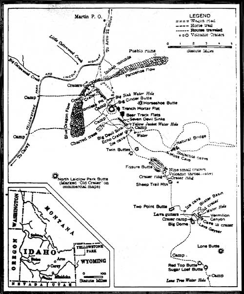
| This map depicts Robert Limbert's explorations of Craters of the Moon, as drawn from his 1924 National Geographic article. |
FIRST CALL FOR A NATIONAL PARK
Robert Limbert's experience traversing the contorted landscape helped him to "appreciate its scenic value." Where others had seen only a barren waste, he found solace and beauty. Here, he wrote, the "human voice seems a sacrilege in the amphitheater [sic] of nature such as these huge craters seem to be." Visually, he was enamored of the "immense rolls and folds of fantastically formed lava...colored blue, black, and brown...the scores of crater rims and walls that start at your very feet and dot the landscape to the horizon line...." Exploring this strange landscape took Limbert to some of the "grandest sights imaginable," from the heights of the great craters to their "deep somber depths." It was awe-inspiring to descend from the scenic feast of surrounding space and sky to crater bottom, and become enveloped in a "red walled funnel," where "one feels little and insignificant, a fly on the wall of the world." [25]
The impression was lasting and moving, and in his descriptions he captured the essence of the area. As he watched the light of sun and moon dance across the cobalt blue lavas of the Blue Dragon Flow, it changed from a "twisted, wavy sea" to a "glazed surface" with a "silvery sheen." Not simply day and night, but all the "changing conditions of light and air" make this a "place of color and silence," a place, with few exceptions, unequaled in "variety of formation, color, and scenic effects" in the world. [26]
Limbert's expression for the lava country's unique beauty found its way into the April 10, 1921 Idaho Sunday Statesman, where he stated that "no more fitting tribute to the volcanic forces which built the great Snake [R]iver [V]alley could be paid than to make this [region] into a national park." [27] True to the promoter that he was, Limbert asserted that the site would attract thousands of visitors, once adequate roads were constructed so travelers could reach the Craters area as they motored to Yellowstone National Park via the Lincoln Highway. All people, he believed, should have the chance to see "these wonders of nature for themselves." [28]
Impassioned about this issue, Limbert called for the state's public to pressure Idaho senators to "introduce a bill suitably framed to give...[Craters] the recognition it deserves." Not only did the area's scenic values drive Limbert's preservation plea, but also what he saw as the threat to the district's archaeological features (Indian cairns and rock hunting blinds), which could be "torn down and destroyed with their contents carried off for the personal gratification of an unthinking few." [29] It was this perception that led Limbert to spearhead a movement on both a local and national level to create a "new national park or monument in many respects the equal and in some easily the peer of many...now within our boundaries." [30]
Following his 1920 exploration, Limbert conducted free lectures around southern Idaho, meeting with civic groups to drum up support for converting the lava district into a national park unit. Heartened by a positive response, he decided to attract national attention by guiding several more trips with scientists and reporters. In June 1921, the explorer-promoter led his most famous investigation of the Craters area for the Idaho Statesman. The party consisted of ten men, who were "equipped to make an exhaustive study of the lava formations, bird and animal life, and explore the many craters." The end result would be a study placed before Congress emphasizing "the possibilities of this wonderland as a national park." Included in the group were local residents, Samuel Paisley and Era Martin; civic leaders, Clarence A. Bottolfsen and Jo G. Martin; as well as two scientists representing both the Biological Survey and the Smithsonian Institution, Luther Goldman and W.E. Crouch. The trip spanned two weeks, during which Limbert snapped more than 276 still photos, recorded an estimated 1400 feet of motion-picture film, as well as produced maps of the lava country's features: ice caves, "bottomless pits," and craters previously uncharted. [31]
|
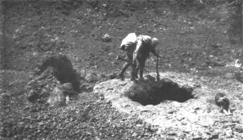
| Exploring the wonders of Craters of the Moon during Robert Limbert's 1921 expedition. (National Geographic) |
Upon his return, Limbert announced that the scenery and natural wonders of the "Moon Valley" were "unexcelled by either the Yellowstone National Park or the Garden of the Gods." [32] To ensure this message reached a wide audience, he published photo essays of the area in a number of regional and national newspapers and magazines. His most famous piece appeared the March 1924 National Geographic. His essay, "Among the Craters of the Moon," with its photographs and map detailed the 1921 expedition's route, though it represented a composite of his several trips. Originally submitted in the fall of 1921, the article was delayed going to press by the Society, which questioned Limbert's findings, and held up publication until his observations could be confirmed. [33]
Two months after the National Geographic appeared, the monument was established. Limbert's role, given the course of events, was instrumental to this outcome. His explorations and essays--both written and photographic--exposed a historically and geographically isolated region to the public at large. [34] More importantly, he espoused a positive attitude for the lava fields that before had been largely unknown or actively avoided.
LOCAL, STATE, AND FEDERAL SUPPORT
As the delay by the National Geographic suggests, Robert Limbert needed help to succeed in establishing a national park for the Craters region. Although evidence of the movement to create the monument outside Limbert's efforts is limited, enough information exists to imply that Limbert himself galvanized the public to action. But at the same time, it should be noted that his reception was positive, hinting that a majority of people already shared his feelings on the uniqueness of the region, or saw its removal from the public domain as insignificant. [35]
When the account of Limbert's 1920 expedition appeared in the spring of 1921, for example, the Idaho Statesman voiced that a movement was already afoot "to have the lava country designated a national park." Stating what reflected, most likely, the stir surrounding Limbert's preparation for his 1921 expedition, the paper noted that "Eastern scientists have expressed great interest in the proposition [to create a park] and Idaho commercial clubs and women's organizations are making individual investigations." Moreover, the paper reported what seems to have been a dominant hope for an isolated and young western state--the establishment of national park. For once that occurred and the area became accessible, "this spot in Idaho may become as great a mecca for tourists as Yellowstone Park." [36]
CIVIC GROUPS AND BOOSTERS
Limbert's influence was infectious, and proved to be a powerful impetus for support. In the wake of his 1921 expedition, some 150 lodges and clubs from around the state had petitioned Congress to set aside the volcanic area as a national park or monument. [37] Two surviving resolutions from Boise civic groups attest to this wide-spread interest and provide a known sample of park advocacy. On May 16, 1921, Limbert spoke to the Pilgrim Brotherhood of the First Congregational Church of Boise about his exploits in the Craters region. And in June this group along with the Boise Community Council drafted similar resolutions petitioning President Warren G. Harding to create the "Valley of the Moon National Monument." As part of its commitment to the movement, the Pilgrim Brotherhood sent Reverend Frederick V. Fisher on an inspection trip to the Craters later that summer. While these petitions and actions represented only a small sampling of the whole state, they echoed the concerns expressed by Limbert in the April publication of his exploratory trip, and resonated throughout the monument movement. [38]
|
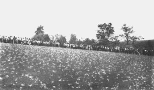
| This large crowd awaits the return of Robert Limbert's 1921 expedition, attesting to the growing popularity of Craters of the Moon's "peculiar scenic wonders." (National Geographic) |
Referring most likely to Limbert's recent investigations of the lava beds and his assessment of their value, the documents exclaimed a standard argument for establishing a national park and particularly relevant to Craters of the Moon; its lands were economically worthless: [39] "this region is not now, nor ever can be of value for agriculture, grazing, lumbering, or any other of the industries of civilization...." And so it followed that it "is alone of value as one of the great scientific and natural wonders of the continents." Designation was imperative; the area was "already threatened with despoliation and exploitation by private and commercial interests for private gain, and...must be carefully guarded at once by the National Government...." [40]
That there were threats seems clear, but what those threats were is less clear. There are, however, some clues. Men like Paisley and Martin were operating guide services, either formally or informally, within the future monument. Limbert expressed concern over this activity, for example, in 1921 when he claimed that unregulated visitor traffic in the lava formations could result in destroyed artifacts. His concern was not unfounded. As a local paper reported, recent improvements to the Carey to Arco highway had opened "Even the mysterious recesses of the `Valley of the Moon'...to the daring automobile tourist." The following year, Limbert confirmed the petitioners' assertions. By then, local commercial clubs had built a rough road into the interior, marked waterholes, and distributed free maps to visitors which he had drawn. [41]
Both the Boise groups and Limbert, it seems, meant residents of the small town of Arco when they mentioned "local" groups. Throughout the few years preceding the monument's establishment, Arco civic leaders provided constant and effusive support for the area's creation. The town's promotion originated with Limbert's activity. The Arco Advertiser covered the explorer's adventures, and based on his opinion, touted Arco as the gateway to this spectacular and little known wonder. Soon the town's interest escalated; it sponsored community picnics at Craters beginning in the summer of 1920. By the end of the year, Arco was showcasing the Lost River region as a "scenic interest," with Craters of the Moon as its central attraction. Here auto tourists could experience the sublimity of the desert wonderland. After leaving Yellowstone National Park for the Sawtooth Range, motorists could stop midway at the Craters, and find in the landscape's dormant and recently cooled lavas a contrast to the park's "eruptive" geysers. [42]
In mid-June 1921, area residents turned out to celebrate Robert Limbert's most recent exploration. More than two hundred picnickers from the Lost River Valley were treated to food, talk, and music by the Arco high school band. Many on the outing experienced the "wonderland" for the first time, and it was such a "huge success" that residents planned others. [43] In doing so, Arcoites demonstrated the growing popularity of the Craters. Already it was an established picnic site, boasted an entrance road, and sign near Martin, directing tourists to the "Valley of the Moon." In addition, large numbers of motorists were reportedly parked by the lava fields and were seen exploring the sites; the area's proximity to the highway made it an "an easy and interesting little excursion." The remains of Limbert's camps, such as a wooden ladder leading into one of the caves, also made the features easier to see, and gave the strange terrain a sense of familiarity. [44]
Economics, however, was the main attraction for supporters of a national park. The Arco Advertiser and Arco Chamber of Commerce recognized the monetary potential from a national park site. The Advertiser's editor and future two-term governor, Clarence A. Bottolfsen, used his paper not only to stump for local and regional support, publicizing Limbert's expeditions and lectures, but also to advertise the Chamber's plans with other communities to attract tourists. In 1922, for instance, the club vowed to "do everything in its power to bring the attraction to the attention of those who would enjoy a trip to the `Craters of the Moon in Idaho.'" It planned a promotional blitz--a flood of circulars, maps, and films to tributary towns along the Idaho Central Highway and adjacent areas--and schemed to improve access roads to the Craters and the primitive loop drive within the monument. Finally, a mother-daughter team from Arco proposed to build a hotel near the present-day entrance. All of this would not only expand upon group outings but promote tourism. Ultimately, towns like Arco, as isolated as the proposed monument itself, would benefit from a tourist season, if only people would but "wake up and do something before the...season arrives and finds us all `asleep at the switch.'" [45]
By 1923, monument promoters added a registration booth to the other developments within the proposed grounds, and had obtained over a thousand signatures on a petition requesting the federal government to designate the region a national monument. While this was positive, especially since the petition represented visitors from across the country, many of those people left with more than scenic satisfaction. [46] At least one local entrepreneur was selling lava bombs and other features to tourists about this same time, underscoring the necessity of protecting the area. [47]
Further indication that the proposed monument was assuming a wider following came in November 1923 when a coalition of civic leaders met in Boise and formed the Craters of the Moon National Park Association. The association members included Governor C.C. Moore, Boise Mayor Eugene B. Sherman, E. W. Shubert of Pocatello, and Robert Limbert, among others. Little is known about this organization and how it functioned, save that it pledged to see that "luncheon clubs in their respective cities, as well as chambers of commerce, pass resolutions calling for conversion of the territory [craters area] into a national park." [48]
CONGRESSIONAL SUPPORT
In 1923, Congressman Addison T. Smith, of Idaho's Second District, responded to public interest and embraced plans for establishing a national monument (or park) in southern Idaho. Smith's support of national parks was somewhat ambiguous. Years earlier he had introduced legislation to create a Sawtooth National Park, and later withdrew it mostly through the protests of Idaho's grazing lobby. [49] In fact, he was known more for his irrigation legislation than promotion of national parks in arid Idaho. In 1919, he introduced a reservoir bill that would have inundated ten thousand acres in the southwestern corner of Yellowstone National Park. [50] In the case of Craters of the Moon, however, Smith's motives seem to have been rooted both in the nature of politics and in a genuine appreciation for the volcanic site.
Smith's support of Craters of the Moon was politically astute. From Twin Falls, he achieved state-wide publicity for his efforts. And by favoring monument rather than park status, Smith did not incur the wrath of the state's resource users. To them, national monuments were less threatening; monument's enclosed smaller tracts of land than parks. As Thomas C. Stanford, an influential livestock owner from nearby Carey, recalled, Smith agreed that a monument was the best choice because it would embrace only the territory where the "historic wonders were located." A park's expansiveness, on the other hand, might include lands outside the immediate scenic sites, infringing on grazing lands considered more valuable left in the public domain. [51]
At the same time, Smith's incentive exceeded mere public recognition. His first visit to the area in September 1923 impressed him so much that he took immediate action to preserve the moon-like landscape. Within weeks of his visit, Smith contacted Gilbert Grosvenor, National Geographic Society president, about publicizing the area, and Stephen T. Mather, director of the National Park Service, about government protection. Concurrently, he conferred with Robert Limbert about seeking national park protection. [52]
The congressman sent both Grosvenor and Mather information about the proposed site, of which Limbert's article, "A Trip to the Moon," composed an important part. Grosvenor responded favorably to the representative's entreaties, additional information, and character reference for Limbert, all of which played a decisive role in pushing through the publication of Limbert's 1924 article. Mather was so influenced by Limbert's "A Trip to the Moon" that he told Smith "there is not the slightest doubt...[that] this area is national monument material of the highest interest." It possessed the "scientific" qualities outlined in the Antiquities Act of 1906. In his enthusiasm, the director even ventured to say that based on Limbert's information alone we might "have it established as a national monument," yet he qualified his excitement by adding, "although I would not want to commit myself at this time." [53]
ROLE OF THE NATIONAL PARK SERVICE AND OTHER AGENCIES
The final stage in creating Craters of the Moon rested with the National Park Service. The Park Service's role appears to have been more reactive than active. Its first contact with the Craters of the Moon proposal, for example, occurred in the summer of 1921 when it received copies of the resolutions by Boise civic groups calling for the area's designation. Acting Director Arno B. Cammerer replied, thanking those individuals involved, and stated that he would try to send "a representative of the National Park Service to inspect the proposed monument sometime soon." [54] Three years passed before the Service, under growing public and political pressure, engaged Harold T. Stearns of the U.S. Geological Survey to report on the proposed monument.
Although Robert Limbert was instrumental in publicizing the volcanic formations, scientists played a central role in the creation of the monument. Washington Irving anticipated this when he wrote "We look forward with impatience for some able geologist to explore this sublime but almost unknown region." [55] Beginning with Russell's investigations at the turn of the century, geologists numbered high among those who visited and showed interest in the area. In this respect, Stearns was just as influential as Limbert, whom he had befriended, in the establishment of Craters of the Moon. Where Limbert provided evidence of the landscape's aesthetic beauty, Stearns supplied evidence of the area's geologic significance that ultimately pushed through its designation.
Prior to being approached by the Service, Stearns had begun to establish himself as an authority on the area. He originally encountered the Craters in 1921. O.E. Meinzer, head of the USGS Ground Water Branch, discovered the Great Rift early that summer, after a trip through what is now the northern end of the monument. Unable to complete a study, he instead advised Stearns to visit the "fresh volcanics" near Arco. Like Meinzer, Stearns' inspection was brief, yet he immediately grasped the area's geologic uniqueness: "Up to the time of discovery of the Great Rift, volcanic phenomena that accompany a fissure eruption were not known to exist in this country." The closest comparisons he could arrive at were Iceland and Hawaii. The formations were unique enough that he returned in 1923 to conduct a more thorough investigation, accompanied by Fred E. Wright of the Carnegie Institution, who confirmed that Craters was in fact "a true fissure eruption." [56]
In January 1924, the National Park Service requested and received from Stearns a report based on his research "describing the area, delineating its boundaries, and stating the reasons for its preservation as a national monument." [57] Stearns believed that a monument
Would preserve for the people of the United States the most recent example of a fissure eruption in this country. It does not duplicate the features of any of the national monuments or parks containing volcanic phenomena. In the existing national monuments and parks there occur only those features that accompany a single volcano.
In addition, a monument would ensure government protection of the area from vandalism, commercial exploitation, and ensure public access and attention to a volcanic area of "curious and educational" interest. [58] Supporting Stearns' recommendation, Meinzer suggested what made the "Craters of the Moon" so special:
I was greatly impressed with the weirdness of the landscape, the freshness of the lava, the abundance, variety and spectacular character of the volcanic features, and the great rift along which the volcanic features are largely arranged. I think there is nothing like it in the United States outside of the island of Hawaii. [59]
Thus, similar to Limbert's enchantment with the lavas' appearance, the geologists were not immune to the landscape's beauty. As Stearns wrote, "Black and barren as it is, the lava surface yet has a weird scenic charm." They were also taken with the variety of features associated with volcanism, and the forces that shaped the Snake River Plain. In the same instance, they were fascinated with "the freshness and barrenness of the black lava flows." One felt as if he had just missed seeing an eruption for himself. Stearns estimated that the most recent flows were possibly only several hundred years old, and early in the 18th century, then, Native Americans may have witnessed fissure vents steaming as the lava extrusions abated. [60]
Besides enlisting Stearns, the Park Service took another step towards final designation of the region as a NPS unit. At Stephen Mather's request, in late December 1923 the commissioner of the General Land Office ordered a formal boundary survey of "a unique area in Idaho" to be set aside as a national monument. The only requirement, in accordance with the Antiquities Act, was that the reservation "be confined to the smallest area compatible with the proper care and management of the objects to be protected." [61] That survey, however, did not occur until a year after the monument's designation. Apparently, the Park Service was willing to recommend the unit for inclusion in the park system based on the information at hand.
On May 1, 1924, the Park Service, with the recommendations of other agencies including the United States Geological Survey and the Smithsonian Institution, submitted its proposal to the secretary of the interior for designating Craters of the Moon a national monument. Acting Secretary E. C. Finney sent the finalized form of the proclamation to President Calvin Coolidge for his consideration. The document utilized Stearns' recommendation for "withdrawing and setting apart approximately thirty-nine square miles of land in Idaho as a national monument to be known as the Craters of the Moon National Monument, in order to protect in the public interest the remarkable volcanic phenomena of this region." [62]
The proclamation before Coolidge had seen little controversy. Having had the approval of both the U.S. Geological Survey and the Smithsonian Institution, [63] the only real problems the Park Service appeared to face were ironing out the minor details of its proposal before seeking presidential approval.
One of these details was the name. The area had been labeled most frequently as "Valley of the Moon." The official name, "Craters of the Moon," was chosen in a survey conducted by the Arco Chamber of Commerce in 1922. The group wanted to avoid confusion with the "Valley of the Moon" in California, and to adopt "something more appropriate and original." [64] The National Geographic followed suit when it changed the title of Limbert's essay to "Craters of the Moon" in March 1924. And the name stuck. Although the Smithsonian objected to this usage, Stearns assured the Park Service that the name was apt for the area because the features resembled the moon as viewed through a telescope. [65] Given the name's descriptive appeal and the fact that it had been nationally publicized, the Park Service settled for Craters of the Moon.
The other point of contention was the monument's size. Park promoters, for example, had speculated that the reserve would encompass 250 square miles. [66] In a February 1924 letter, Robert Limbert notified Addison Smith that he and many Arco residents thought Stearns' recommendation "was not nearly big enough." [67] Limbert and company, though, were unable to change the original document. Part of the problem lay in the fact that monuments were to be small, protecting only the most important features, and for this reason cries for a larger size fell on deaf ears. The other part of the problem stemmed from the proposed monument's remoteness, isolation, and forbidding lava features. While these physical conditions posed no public controversy over economic use of the land, they caused problems in drawing boundaries. As of 1924, the area remained an unsurveyed section of the public domain, and the new monument lacked even the General Land Office's acreage assessment. [68] For this reason, Stearns noted, "it was obviously impossible to locate and include in it [the monument] all the important and unique volcanic features." [69]
After several years of advocating the establishment of a National Park Service unit, Robert Limbert, Arcoites, and others in the state of Idaho saw their efforts come to fruition on May 2, 1924, when President Calvin Coolidge signed the proclamation establishing Craters of the Moon National Monument. [70] Enacted under the Antiquities Act, the monument fit within the legislation's broad guidelines, whereby the president was empowered
to declare by public proclamation historic landmarks, historic and prehistoric structures, and other objects of historic or scientific interest that are situated upon the lands owned or controlled by the Government of the United States to be national monuments.... [71]
Craters of the Moon was at the time the thirtieth monument administered by the Department of the Interior, and Idaho's first National Park Service area. To celebrate this milestone, on June 15, 1924, Arco sponsored the monument's dedication ceremony. Some fifteen hundred people attended from central and southeastern Idaho, featuring those individuals and groups influential in seeking the area's creation (the Park Service was apparently absent). Establishment brought to a close the movement to preserve the "Lava wonderland." It also opened a new chapter for the remote section of Idaho. As the Advertiser reported, "it puts the community on the map as one of the scenic districts in the west. [72]
|
|
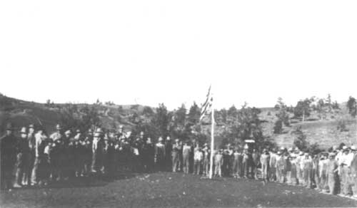
Opening Day, June 1924, Arco residents celebrate the
establishment of Craters of the Moon National Monument. (CRMO Museum Collection) |
| <<< Previous | <<< Contents>>> | Next >>> |
adhi/chap3.htm
Last Updated: 27-Sep-1999