|
CABRILLO
The Guns of San Diego Historic Resource Study |

|
CHAPTER 3:
POINT LOMA AND COASTAL DEFENSE, 1852-1874
A. A Military Reservation
Almost as soon as American forces occupied California, the War Department organized the territory as the Tenth Military Department with headquarters at Monterey. Brig. Gen. Stephen Watts Kearny became the first commander in February 1847, soon to be succeeded by Col. Richard Barnes Mason. Both officers took steps to reserve parcels of land for use by the military. Lt. Henry W. Halleck, on Kearny's staff, visited San Diego in 1847 and recommended coastal defenses for Point Guijarros on Point Loma. In 1849 the Secretaries of War and the Navy appointed a joint commission of three army engineer officers and three naval officers to plan the defenses of the Pacific Coast. Delayed on account of enlisted desertions to the gold mines, the commission did not begin its surveys until 1850. Traveling on board the army transport Massachusetts, the officers examined San Francisco Bay, the mouth of the Columbia River in Oregon Territory, and San Diego Bay.
While concluding that San Francisco and the Columbia River should have priority over San Diego, the commissioners were impressed with the last, "San Diego Harbor is in many respects the best on this coast." It was spacious, sheltered, free from shoals, secure from storms, and the narrow entrance could be easily defended. "It is a remarkable harbor and a valuable acquisition to a coast where good harbors are rare." The officers noted that a battery could be constructed on either side of the entrance but that "Punta de Guiranos" (sic) was preferred. Since the point could be attacked on the land side from the heights of Point Loma that area must be occupied by a strong work. [1]
President Millard Fillmore signed an Executive Order on February 26, 1852, establishing the Point Loma Military Reservation consisting of 1,300.42 acres. The northern boundary of the reservation was a straight line from the bay to the ocean 1-1/2 miles north of Ballast Point. Neither Congress nor the War Department took action at this time to fortify the bay. The tumultuous affairs of Northern California and Indian wars in Oregon no doubt took precedence over the sleepy port. The first United States census in California, in 1850, showed a population in the San Diego area of 798 people. [2]
The Army's Chief Engineer Joseph G. Totten inspected the Pacific Coast regarding its defenses in the winter of 1859-1860. He agreed with the findings of the joint commission, particularly with regard to San Diego. He noted that it stood at one end of a 500-mile coastline with San Francisco at the other end, "The admirable properties of San Diego Harbor - deep, close, roomy and defensible - its position just at the southern limit of our possessions, with no other to compare with it within a long distance, raise it beyond all question into the first class; and demand for its defenses...." Despite all the praises of its merits, San Diego Bay remained undefended as the nation drifted toward civil war. [3]
B. Old Point Loma Lighthouse [4]
It is said that the only navigational aid in San Diego Bay in the early years was a lantern hanging from a pole at Ballast Point. Then, in 1852, Congress authorized the first eight lights for the Pacific Coast. These lights marked two significance advances in the history of navigational aids in the United States. The administration of such aids acquired a high degree of professionalism with the establishment of the Lighthouse Board composed mostly of military engineers. Also, the West Coast lights were to be illuminated by a new, greatly improved method, the French-designed Fresnel lens system. In 1854, a contractor completed construction of one of these lighthouses on Point Loma's highest point, 422 feet elevation.
To get his construction materials to the site, the contractor built a crude road from Ballast Point to the top of Point Loma. The two-story sandstone lighthouse measured twenty by thirty feet. A brick tower, forty feet tall rose from the center of the house. A third order (out of seven) Fresnel lens was installed and the light was lit November 15, 1855. For the next thirty-six years, the Point Loma light served mariners at sea and as a harbor light for San Diego. It was the highest light in the United States, which fact quickly became a problem when coastal fog dimmed its usefulness. In 1891 the light was abandoned and a new light was erected at the tip of Point Loma at an elevation of thirty feet, below the fog. In addition to this new site, the War Department issued another permit for a light at the end of Ballast Point to serve as a harbor light.
The old lighthouse, which became known as "the old Spanish lighthouse," became a favorite tourist destination because of the magnificent views obtained there of San Diego and the Pacific Ocean. In 1913 President Woodrow Wilson issued a proclamation setting aside the lighthouse and the one-half acre of land surrounding it as Cabrillo National Monument in honor of San Diego's discoverer. The U.S. Army administered the monument until 1933 when it turned it over to the U. S. Department of the Interior to become part of the National Park system. Except for the war years 1941-1946, the National Park Service has continued to administer the greatly enlarged national monument. [5]
C. The First Battery, 1870s
By the time of the Civil War, San Diego's population had grown fivefold, to 4,300. Army engineers at San Francisco, concerned that Great Britain, which was friendly with the Confederacy, might attack California from its naval base on Vancouver Island and worried about Confederate raiders in the Pacific, sought to increase San Francisco's harbor defenses. As for San Diego, however, the small garrison of California Volunteers at the Barracks had to suffice for the town's defense. Except for an occasional Southern sympathizer expressing his views, however, San Diego survived the war in peace.
Following the war, army engineers realized that advances in warfare, such as rifled artillery and steam-propelled warships protected with iron armor, had made the handsome and costly masonry casemated forts of the past obsolete. Engineer boards in both San Francisco and New York began planning the fortifications of the future. In 1868, the New York board prepared a report detailing the proper profile for postwar barbette batteries. As a material for parapets, sand was far superior to clay. A parapet of sand, twenty feet between the crests and supported by a breast-height wall four feet thick was sufficient as a minimum. The distance between 15-inch Rodman guns should be twenty-four feet. The terreplein should not be less than thirty feet in depth. There should be a traverse for every two guns. The minimum dimensions for a traverse should be fourteen feet in height, twelve feet in thickness at the top, and twenty feet thick at the bottom. Service magazines were indispensable and should be made of well-rammed concrete with no lining. E. Raymond Lewis wrote, "Never again would forts be built in the storybook style as single structures housing large numbers of cannon. From this time on, a fort was a piece of real estate occupied by a number of dispersed individual batteries." [6]
Soon after the war, the Army underwent a major reorganization. On the West Coast the Division of the Pacific was constituted with Maj. Gen. Henry W. Halleck as its commander, the same person who had inspected San Diego Harbor in 1847. The new senior engineer on the Pacific Coast, Maj. Barton Stone Alexander, convened a board of engineers in 1867 to consider the future of the coastal defenses. This time San Diego was included in the planning. [7]
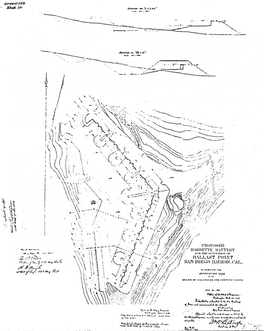
San Diego's population had grown to almost 5,000 by the time of the 1870 census. In 1871 an announcement was made that the Texas & Pacific would construct a railroad linking San Diego to the east. While the announcement proved premature, it pointed up that San Diego was soon to be an important port of call. The Board of Engineers in San Francisco prepared plans for a barbette water battery to be located at the junction of Ballast Point and Point Loma, near the site of former Fort Guijarros. These plans followed the concepts of the 1868 New York board's report. The work had two parts: the battery proper, a triangular earthwork having positions for fifteen 15-inch Rodman smoothbores and four mortars; and an outwork on the point itself which had positions for seven of the heavy guns and two mortars. [8]
The Pacific Board forwarded the plan to Washington in May 1871 and in June the Chief of Engineers sent it on to the Board of Engineers for Fortifications in New York for review. The plan was returned to San Francisco with recommendations for modifications, the principal one being the deletion of the outwork. Finally, Secretary of War William W. Belknap approved the plan in March 1873. It called for an earthwork containing guns mounted in pairs (with one exception), and the pairs separated by earthen traverses, each containing a magazine. All mortars had been deleted from the battery. A slight mound shown to the east of the battery and just outside the parapet seemed to mark the site of ancient Fort Guijarros. [9]
Congress passed an appropriation of $50,000 for San Diego for fiscal year 1874. Even before the fiscal year began on July 1, The San Diego Union learned that Lt. John H. Weeden, Corps of Engineers, would soon arrive from San Francisco to supervise construction of the battery. The lieutenant, accompanied by his superior officer, Lt. Col. Charles S. Stewart, arrived in San Diego in May, and work was commenced at Ballast Point promptly. Temporary quarters for overseers sprang up, as did a storehouse, messhouse, and a stable. Unfortunately, the work ran out of money in April 1874, never to be resumed. In fiscal year 1876, Congress refused to pass any appropriations for new fortifications nationwide, a drought that lasted fifteen years. In 1897 the incomplete battery was obliterated in the construction of a new battery. A site map drawn in 1896 showed the one concrete magazine that had been constructed in 1874. It was located at the west end of the battery in the traverse between guns two and three, at the proposed gun emplacement no. 1 of the future Battery Wilkeson. The construction of Wilkeson resulted in the destruction of the magazine. [10]
|
| Plans for a barbette battery of fifteen 15-inch Rodman guns were approved in 1873. Work began at the neck of Ballast Point but the project ran out of funds in 1874, never to be resumed. Only one concrete magazine had been completed. The unnamed battery would have been similar to Battery Cavallo in the harbor defenses of San Francisco. National Archives, RG 77, Fortifications File, Dr. 102, Sht. 10. (click on image for an enlargement in a new window) |
| <<< Previous | <<< Contents >>> | Next >>> |
cabr/guns-san-diego/hrs3.htm
Last Updated: 19-Jan-2005