|
Land of Contrast: A History of Southeast Colorado BLM Cultural Resources Series (Colorado: No. 17) |

|
Chapter XIII
FROM WAR TO PROSPERITY: 1940-1980
As Hitler's armies marched through Poland in 1939 and then turned on France in 1940, England was left to stand alone against the German war machine. President Franklin D. Roosevelt provided aid to the United Kingdom through his Lend-Lease Program, by which war materials and foodstuffs were shipped to Britain to sustain that country. As the war gained momentum, American industry and the farm community were called upon to provide goods and food. Farm prices rose quickly in the early 1940's, and southeast Colorado directly benefited. Sugar beet production, dryland wheat planting and cattle and sheep raising all increased while other farm goods like hay, oats, corn and vegetables also saw rising prices on the world market. Only five years before, the Federal Government paid farmers not to plant because of depressed prices. Now, heedless of the past, farmers planted every acre they could find, and agriculture boomed. The days of the Dust Bowl were forgotten as was the help offered by the Roosevelt administration during the 1930's. Farmers told governmental officials from the Farmer's Home Administration to the Soil Conservation Service to "get off our backs's" and let the free market determine prices. [1] The lessons of just ten years previous were totally forgotten.
Industry also revived from depression, thanks to the "war boom." Colorado Fuel and Iron of Pueblo had both new domestic and foreign orders for steel. American Metal Climax, near Leadville, saw molybdenum production rise, as demand for steel and other alloys rose. Precious minerals like gold and silver were mined in increased quantities as were zinc, lead and copper. The depression was well on the way to recovery by early 1941. Railroad traffic was up, industrial output increased, and agricultural enterprises flourished. Little did anyone know that Colorado, in fact the entire nation, would be plunged into war later that year. [2] On December 7, 1941, Japanese navy planes attacked the Pacific Fleet stationed at Pearl Harbor, Hawaii. Most American ships lying at anchor were either destroyed or badly damaged. The United States declared war on Japan and Germany. All national resourses were committed to the battle. Not only did the agricultural community boom, but nearly all industrial complexes operated at full capacity. Railroads, the nation's main transportation system, were pressed into service. The Denver and Rio Grande, the Santa Fe, the Missouri Pacific and the Colorado and Southern all had more traffic than they could handle. Revenues increased accordingly. [3]
The war with Japan also brought about one of the most massive violations of the Constitution in American history. In early 1942, Japanese-Americans were rounded up along the west coast as "dangerous." These people were U.S. citizens, but their property was confiscated, and they were placed in what were called "Detention Centers." There was a difference between Hitler's concentration camps and the American version. The Japanese were not systematically exterminated. Colorado was the scene of some of this mass deportation. In August 1942, about 8,000 Japanese were moved to a campsite near Granada, Colorado along the Arkansas River. At this place 11,000 acres were set aside for construction of barracks, social halls, and agricultural fields. The camp was called "Amache" (after J.W. Prowers' Indian wife) or, more formally, the Granada Relocation Camp. Camp Amache became a small city with its own internal government, newspaper and schools. However, residents' movements were severely restricted. Amache was not a pleasant place; water had to be hauled in due to undrinkable local sources, meals were served in three or four shifts, and very few of the huts had running water. The "internees" were offered work in sugar beet fields surrounding Granada and by 1945, Amache had 9,000 acres of irrigated beet land under production, managed by the American Crystal Sugar Company. The nearest large town, Lamar, at first wanted the camp because it pumped $5 million into the local economy, but there was a strong anti-Japanese prejudice. Store windows carried signs "No Japs Wanted." Eventually, Lamar's merchants realized that it was good business to cater to Japanese-American buyers and stores soon welcomed the prisoners. There was also some anti-Japanese sentiment at Swink and La Junta, where it was suggested that these people would drive down the price of local labor. [4] Despite local fears, the camp was built to stay. By 1943, camp conditions were improving and included the establishment of a chapter of the Future Farmers of America, an American Legion Post, the YMCA and YWCA, and an extension division from the University of Colorado. Camp Amache's existence ended in October 1945, when its citizens were repatriated to California and other west coast states. Granada was not the only place Japanese-Americans went as they were displaced.
Eastdale, in the San Luis Valley, also saw a number of California Japanese-American farmers move into the area during 1942 where they took up vegetable farming. Eastdale, originally a religious settlement, was later populated by Japanese-Americans when encouraged to do so by the colonization company that ran this colony. In this way, the truck gardens were well established when the war came. Relatives and friends of Eastdale's Japanese population moved there when removed from the west coast as "security risks." Considerable numbers of Japanese-Americans also settled near Blanca and Fort Garland in the 1940's where vegetable farming made them famous. [5]

|
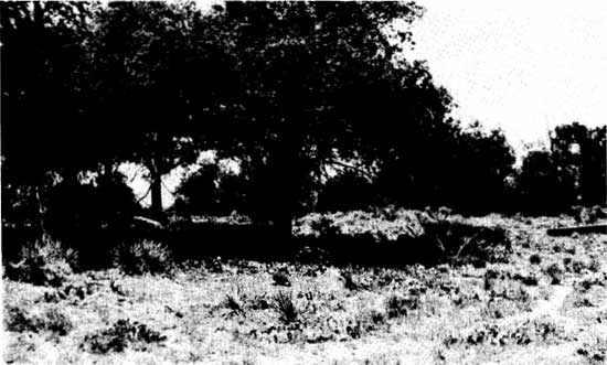
| What remains of Camp Amache are foundations and bitter memories. This Japanese "relocation" camp was located just north of Granada, Colorado and was in use until 1945. (Photo by F. J. Athearn) |
|
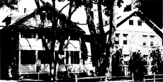
| Beyond the foundations, some of the original barracks have been remodeled and are used for housing migrant laborers, mainly Mexican nationals. (Photo by F. J. Athearn) |
The other major result of World War II was the infusion of "foreign" population to Colorado. Not only did manufacturers like CF&I need labor, but small firms got big government contracts that, in turn, caused worker shortages. This demand for laborers caused migration from both the south and midwest. Workers were paid good wages at both industrial and military facilities. This helped attract new people to the State. Colorado's minority population, particularly Mexican-American, found job opportunities increasing as the war progressed. President Roosevelt's Executive Order of 1943, forbidding discrimination by Federal contractors, helped open new markets for a population previously totally frozen out. This was the forerunner of substantial change in the state's population base and the social-economic makeup of the region. [6]
|
| The Fort Lyon V.A. hospital, near Las Animas, is named for a previous fort along the Arkansas. This place represents some of the military/government spending that took place during World War II and that is still a powerful economic force in this region. (Photo by F.J. Athearn) |
The war brought military facilities to Colorado on a large scale. The presence of military camps and forts was a traditional source of local income, and when new bases were placed in Colorado (because Axis bombers could not reach this state), small and large towns benefited. Southeast Colorado got its share starting in 1942, when the Pueblo Ordnance Depot was constructed. An airfield to train British pilots was built at La Junta. Near Leadville, Camp Hale was established to train the 10th Mountain Division in alpine war tactics. Possibly the most import and and longest-lasting base was Camp Carson, set up south of Colorado Springs in 1943, for the purpose of training combat soldiers. Some 60,000 acres were set aside about six miles south of that city. This brought $30 million into Colorado's economy and proved one of the most important contributions of World War II in southern Colorado. [7] Pueblo, in 1943, also got an airbase to train bombardiers; $9 million came to that city from the war. Denver, of course, got the most in military increases. Lowry Air Force Base, the Rocky Mountain Arsenal, the Denver Ordnance Plant (now the Federal Center), and Buckley Naval Air Station all benefited that city. Nevertheless, southeastern Colorado fared rather well. Modern Pueblo and Colorado Springs got their starts at this time, thanks to war-generated income. [8]
Later, shortages not only brought immigrants into the state, but also cost unions considerable power. While the 1930's saw major gains in unionism, the 1943 Colorado Labor Peace Act virtually wiped out every labor gain "made since the days of Ludlow." Mass picketing, all-union shops, secondary boycotts, and the use of union funds for political purposes were all outlawed. These restrictions to labor affected the miners of southeastern Colorado as well as factory laborers in places like Pueblo. These laws were gradually rescinded, but not without having done considerable damage to the labor movement in not only Colorado, but particularly in the Pueblo-Trinidad region. [9]
As World War II came to an end, Colorado's future was changed forever by events of the past five years. By the time of Japan's surrender, farm prices were already falling and industrial output was down. Recession was on the horizon, as noted by the Colorado Stock Growers and Feeders Association which admitted: "We've got more cattle than we can handle." Coal production reached an all-time high in 1943, and then declined to almost nothing during the early 1950's. Oil and gas production soared during the war, and older fields like Florence were extensively pumped. Again, as war ended, oil prices fell and production slowed. [10]
By the end of the forties, recession set in and southeast Colorado began to look rather like the late thirties. There was one significant difference: the ever-increasing presence of the Federal Government. World War II's military bases remained, although on a lesser scale. Farm programs like the Soil Conservation Service and Farmer's Home Administration were strong on the eastern plains. Where offices were opened, the local economy benefited. The Comanche National Grasslands, created from Bankhead-Jones Land Utilization Repurchase Act lands, during the 1930's, were administered from Springfield, Colorado. The U.S. Forest Service opened an office here to handle the 420,000 acres for which it was responsible in 1954. Springfield got some badly needed economic help. [11] The 1950's were generally a period of low farm prices, falling demand for minerals and a desperate attempt to "sell Colorado" to easterners. Southeastern Colorado, primarily dependent upon agriculture, suffered intensely. Sugar beet prices dropped, as did beef and wheat demand. Farmers planted more and more hoping to make up for losses. Equally, the Trinidad-Walsenburg region saw mine closings on a regular basis. The coal market was limited to CF&I's Pueblo plant and, as a result, only a few company-owned mines west of Trinidad, at Weston and Primero, remained operational. Colorado Fuel and Iron, however, did expand through purchases of subsidiary companies on both the east and west coasts. Such diversification provided little relief for local unemployment problems.
Mining at Climax continued, and AMAX expanded its operations. World wide demand for replacement steel caused molybdenum prices to rise. Traditional mineral operations, like the limestone quarry at Howard, gypsum mining at Coaldale, granite quarries near Cotopaxi, the Colorado Portland Cement plant at Portland, Colorado and other nonprecious mineral operations continued to provide economic help to Fremont County. [12] Canon City also saw construction of a uranium processing plant south of that city in 1958. The Cotter Corporation built a "yellow cake" facility and generated considerable enthusiasm from Canon City's residents, who saw another "uranium boom" about to happen. There was no renewed rush, and Cotter, while adding to the local economy, did not greatly expand Fremont County's mineral industry. The Cotter Mill, during the late 1970's, became a source of concern when it was discovered that radioactive tailings were allegedly seeping into ground water supplies. Cotter eventually agreed to clean up its operations and residents breathed a sigh of relief. [13]
During the 1950's, Colorado's government undertook an ambitious campaign to attract tourists, on the basis that it was a "clean" industry, and also to gain so-called high technology businesses that would not be "industrial" in the fashion of CF&I or Gates Rubber. Such industry included the National Bureau of Standards at Boulder, the Rocky Flats Nuclear Weapons Plant just north of Arvada, and the Air Force Academy, outside of Colorado Springs. Southeastern Colorado did not generally share in these "benefits" other than at Pueblo where the Department of Transportation built, in the 1960's, a test track for cars and trains. There were a few other "clean" businesses introduced. For instance, Pueblo became a major GSA publication distribution center for Federal booklets ranging from consumer protection to abortion. Pueblo also saw some industrial growth when the Triplex Corporation of Chicago moved to the City on the Arkansas. These gains were offset by closures like the Golden Cycle Mill at Colorado Springs during 1958, which ended further serious mining at Cripple Creek and Victor. [14] Along the Arkansas, as agriculture retracted, cities like Lamar, La Junta and Rocky Ford sought new life. Sugar beet factories closed and local economies suffered considerably. In 1978, Lamar was able to attract a bus assembly plant that provided local employment. In fact, during 1981, the company was awarded the world's largest bus construction contract to build buses for numerous cities. Lamar Junior College experienced growth due to veterans from both World War II and the Korean Conflict taking advantage of their GI Benefits. Pueblo's college and Trinidad State Junior College also saw enrollments jump. Adams State College at Alamosa had good growth during the 1950's and well into the 1960's. College enrollment reflected not only returning GI's, but also a new recognition of the value of higher education. [15]
The fifties dragged into the decade of 1960 with indifference. The sixties did see changes in Colorado, but not along the Arkansas. Here life, based on farming, went on. The Pueblo-Trinidad corridor was provided with a new interstate highway during this time. Interstate-25 extended from Denver south to Pueblo, Walsenburg, Trinidad and over Raton Pass. Pueblo was cut in half by the four lanes, Walsenburg was totally by-passed, which proved rather disastrous to local merchants and Trinidad became a stop before or after Raton Pass. Motels, fast food chains and service stations dot the Interstate at Pueblo and Trinidad. Tourists, as in the 1870's, provided income for a sagging economy. Tourism also played a serious role in helping older mining towns survive. Cripple Creek was "refurbished" in a tasteless effort to attract unsophisticated "flatlanders." The town was listed on the National Register of Historic Places in 1966, which at least helped preserve what little integrity was left. Victor, on the other hand, was forgotten and remains a real gem for the tourist in search of a relatively authentic mining town. Creede, too, was left fairly well alone, probably because of its isolation. Leadville was never fully abandoned and the AMAX mine at Climax provided a stable population base. The town was "painted up" to some extent, especially in the core area around the Tabor Opera House. This part of town was also listed in the National Register of Historic Places (1966) which helps the city maintain some semblance of historic order. An extreme example of tasteless tourism came at the Royal Gorge, where a whole western town called Buckskin Joe was "reconstructed." It competes with all sorts of gaudy sideshows for tourist's dollars. [16] On the opposite side, the San Luis Valley did not see tourism prosper. Perhaps this was because the main road, U.S. 285 just went through, and because the place had nothing "worthy" of note for "flatlanders." The San Luis Valley does contain several places that are off the beaten tourist path. The Sand Dunes National Monument and the Wheeler National Monument are just isolated enough to provide them with protection from the garish exploitation front range sites underwent. [17]
Along the Arkansas River Valley, water became an even more serious issue during the early 1960's. In 1962, Congress authorized construction of the Frying Pan-Arkansas Project to divert water from west of Leadville, through several tunnels, to the Upper Arkansas River where it would be used for irrigation. Representative J. Edgar Chenoweth, of Trinidad, was primarily responsible for this feat. Farmers on the lower Arkansas praised the Frying Pan-Arkansas Project for bringing them more agricultural water, while those on the western slope condemned diversion as destroying resources on that side of the Divide. [18]
The decade of the seventies was similar to the previous twenty years, in that economic growth was slow but steady. Perhaps of more importance was an influx of new population, the discovery of the foothills for recreation, and a social-political revolution. The far eastern plains remained little changed from earlier days. Agriculture, some industry and a few tourists represented ongoing life. Closer to the front range, the story was different. The corridor from Pueblo north became quite populated and urban growth occurred from Fort Collins southward. Here is where the majority of Colorado's citizens became located, and with such expansion, the "evils" of city life came to southeastern Colorado. Pueblo, for one, became polluted by cars, industry and bad air drifting south from Denver. Yet the city grew and retained its position as the state's third largest city. Places like Trinidad and Walsenburg did not experience such growth, but rather, their populations stabilized and these towns remained regional supply centers. Social unrest was minimal in the far southern part of the state for the Mexican-American population was well integrated into the infrastructure of government and society. The ethnic mixture of Trinidad is interesting because it contains Mexican-Americans, Italian, Eastern European and Anglo cultures, all existing together. The far eastern plains never did have serious racial problems for Anglo-American farmers were always in control. As population decreases occurred due to farm failures, labor became scarce. Early, sugar beets required "stoop labor" and Mexican-Americans or Mexican nationals were imported to do the job. As time went on, migrant laborers were used to pick beets and other specialty crops on a seasonal basis. The abuses that occurred were many. Laborers were paid low wages and given no benefits. Their children were not placed in public schools and the shacks they lived in were primitive at best. Clear-cut racial discrimination was a way of life for Mexican-American residents in Colorado. Denver, Colorado Springs and Pueblo were notorious for their anti-Hispanic attitudes. The San Luis Valley did not suffer from these tensions, primarily because the majority of the Valley's population was Spanish surname. Local officials and state-level representatives from the Valley were traditionally Hispanic and these trends continue into the present. While there was unrest on college campuses, southern Colorado did not see much of the national and state ferment that swept the minorities. Demonstrations at Adams State and Southern Colorado College reflected overall anti-establishment feelings of students, rather than broad-based minority demands. [19] The considerable influx of new population to the Front Range spilled over into traditionally Hispanic (or other ethnic) regions. The San Luis Valley, historically Hispanic, by 1960 could boast that only Costilla and Conejos Counties were "Mexican" in social make-up. Overall, the ethnic difficulties that beset northeastern Colorado were not as strong or violent in the southeast. The long tradition of multi-ethnic population can be credited for a lack of crisis during the 1960's and 1970s. [20]
|
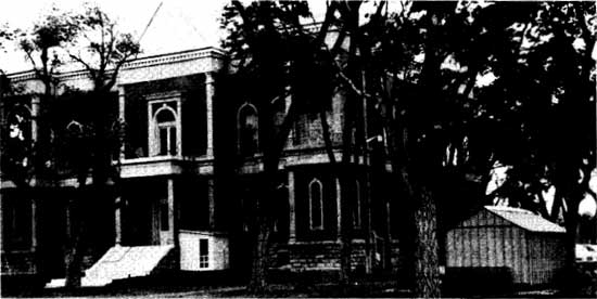
| The Victorian courthouse at Las Animas represents a past that has seen growth from a hostile land to a fully modern society. The building, erected in the 1880's, has stood the test of time. (Photo by F. J. Athearn) |
|
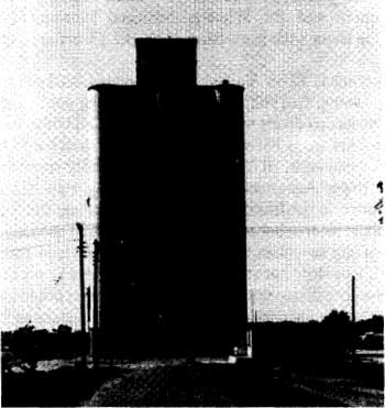
| The most unbiquitous structure on the plains of southeast Colorado is the ever-present grain elevator. (Photo by F. J. Athearn) |
The other significant event emerging during the 1970's was what came to be called the "Environmental Movement." It was the grandchild of the Conservation Movement that occurred during the early 1900's. From the creation of the National Forests in 1891 to the closing of the public lands in 1934, interest waned. Perhaps this was due to the "Roaring Twenties" when times were good, or to the depth of the Depression when resource conservation was not important. During the late 1960's, politically active conservation groups (lobbies) pressured Congress to the point that the National Environmental Policy Act (NEPA) was passed during 1969. This was the crowning glory for the environmentalist/conservationist movement. The new law provided national policy that required the consideration of environmental consequences for all major Federal actions. The act created considerable awareness, among the public, that the environment was fragile and should be protected. It may be argued that NEPA only created a new bureaucracy and slowed progress, but on the other hand, valuable ecological and other resources have been preserved due directly to NEPA. [21] In 1964, the Wilderness Act was passed. This legislation, a forerunner of NEPA, set the stage for creation of Wilderness Areas and affected primarily the Forest Service, which was told to inventory and then name sites that were "potential" Wilderness Areas. In the process, seven areas in southeastern Colorado were designated wilderness. They were La Garita, Collegiate Peaks, Mt. Massive, Holy Cross, Lost Creek, South San Juan and the Great Sand Dunes. All but one are administered by the U.S. Forest Service; the Sand Dunes is a National Monument. The Colorado "environmentalists" enjoyed their greatest triumph in 1973 when, thanks to intense pressure, Colorado withdrew its bid for the Winter Olympics. The environmental controversy that embroiled the Olympics may have been the peak of environmental power in this state for, from that point on, more moderate views were touted both among hard-core environmentalists and private industry. Most recently, the U.S. Army's plans to expand Fort Carson into the Pinon Canyon area, east of Trinidad, has generated considerable environmental discussion. [22]
Present-day activities in this region are traditional. Agriculture remains the primary economic force in southeastern Colorado. Wheat, hay, some sugar beets, fruit, beans, barley and other staples are the primary crops. The far eastern plains, the San Luis Valley, South Park and the Wet Mountain Valley are all agricultural in nature. Energy development is beginning to revive. Coal, of course, was once a primary economic force in this region. But today only CF&I still mines this mineral at Weston for its Pueblo Plant. However, with the 1973 oil shortage, there was talk of the vast coal deposits in the Raton Basin. The Federal Government, which controls considerable blocks of coal lands, is considering the possibility of leasing these reserves, but due to the current oil glut nothing has happened. The San Luis Valley has seen some oil and gas drilling activity. More interesting is the Valley's geothermal potential. Exploratory works have occurred in this area with the hope of tapping steam for energy. Near Walsenburg, carbon dioxide (CO2) is being removed from Sheep Mountain and sent by pipeline to Texas, where it is used for recovery in older wells. Atlantic-Richfield operates a large CO2 field in this area and is continuing exploration. With this interest in minerals and energy-related products, southeast Colorado may find itself once again a dominant producer of fuels. The old days of coal mining could again drive this economy. But there are many who will not forget the day the mines closed and will always watch with suspicion "big plans" for mining.
Southeastern Colorado is a place of many contrasts. From snow-capped peaks on the west to high plains on the east, this area has seen slow changes. First users were Native Americans who exploited the rich natural resources. Following them, several nations claimed the region. Spanish, French, Confederate and American flags flew over the land at one time or another. All peoples used the land in their own ways, depending upon need and level of cultural development. However, the progression of southeast Colorado's history was classically "western" in nature. From fur trappers to miners to cattlemen to settlers to town builders, the Arkansas River Valley grew in a traditional and steady manner. The Upper Arkansas was built on mineral extraction and remains tied to mining for its life. South Park has changed very little since mining died. Cattle raising, hay growing and a few seedy subdivisions sustain the park. The San Luis Valley was different. Culturally, it was New Mexican and has remained so to the present. Anglo-American influences came from some miners and a few settlers. Other than these intrusions, the Valley remains wonderfully unique.
Perhaps southeastern Colorado is different because it is one place that change has occurred slowly. It has been said that the more things change the more they stay the same, which is certainly true for this part of our state.
CHAPTER XIII: NOTES
1. Worster, op. cit. See also: Paul Bonnifield, The Dust Bowl, Men, Dirt, Depression (Albuquerque: University of New Mexico Press, 1979.)
2. John H. Thompson, "The Molybdenum Industry at Climax, Colorado" (M.A. Thesis, University of Colorado, 1943), pp. 6-25, and Athearn, Coloradans, op. cit., pp. 301-302.
3. Athearn, Rio Grande, op. cit., pp. 318-320, and Overton, op. cit., p.
4. Athearn, Coloradans, op. cit., pp. 298-299, and Ubbelohde, Benson and Smith, Colorado, op. cit., p. 330.
5. Simmons, op. cit., and Shirley Fujikawa, "Eastdale, Colorado: A Picture Window Settlement" (Boulder, Colorado: University of Colorado, n.d., Seminar Paper.)
6. Athearn, Coloradans, op. cit., p. 301, 303 and 305.
7. Ubbelohde, Benson and Smith, op. cit., pp. 330, 332 and No Author, Fort Carson: A Tradition of Victory (Ft. Carson, Colorado: Public Affairs and Information Office, 1972.)
8. Athearn, Coloradans, op. cit., p. 297, and Trindell, "Occupance," op. cit.
9. Ubbelohde, Benson and Smith, op. cit., p. 327, and Athearn, Coloradans, op. cit., p. 303.
10. Colorado State Planning Commission, Yearbook of the State of Colorado, 1941-1942, (Denver: Smith-Brooks, 1942) and Colorado State Planning Commission, Yearbook of the State of Colorado, 1945-1947, (Denver: n.p., 1947.)
11. Culhane, Public Lands, op. cit., p. 48, and Interview, with Robert E. Wagner, Bureau of Land Management, Denver, Colorado, May 19, 1982.
12. Colorado Bureau of Mines, Report for the Year 1960 (Denver: State Printers, 1961), p. 24.
13. "Cotter Corporation Plant Producing Uranium Oxide Yellow Cake," Canon City Record, September 11, 1958, p. 5, and W.T. Little "New Metal Treatment Mill Already Studying Expansion," Rocky Mountain News, December 9, 1964, p. 34.
14. Athearn, Coloradans, op. cit., pp. 319-320.
15. Ubbelohde, Benson and Smith, op. cit., p. 340.
16. U.S. Department of the Interior, National Park Service, National Register of Historic Places, Vol. 44, No. 26 (Washington, DC: GPO, 1979), pp. 7437-7440, and Athearn, Coloradans, op. cit., p. 324.
18. See: Robert G. Dunbar, "Water Conflicts and Controls" in: A Colorado Reader, Carl Ubbelohde, (Ed.) (Boulder: Pruett, 1962), pp. 219-230; Trindell, "Occupance," op. cit., pp. 148-149; and Athearn, Coloradans, op. cit., p. 294.
19. Athearn, Coloradans, ibid., p. 342; Matt S. Meier and Feliciano Rivera, The Chicanos: A History of Mexican Americans (New York: n.p., 1972) and Jose de Onis, The Hispanic Contribution to the State of Colorado (Boulder: Westview Press, 1976.)
20. Simmons, op. cit., and Athearn, Coloradans, op. cit., p. 339.
21. Culhane, op. cit., pp. 54-55.
22. Athearn, ibid., pp. 357-360 and p. 398.
| <<< Previous | <<< Contents>>> | Next >>> |
co/17/chap13.htm
Last Updated: 20-Nov-2008