|
Frontier in Transition: A History of Southwestern Colorado BLM Cultural Resources Series (Colorado: No. 10) |

|
CHAPTER VIII:
Transportation and Mining (1881-1920)
Railroad construction in southwestern Colorado was the foundation on which the region developed during the last two decades of the nineteenth century. The benefits created by such activity influenced almost every aspect of economic, political, and social life. Railroad building linked the area to the important industrial centers of the state and nation, and opened a period of advancement that affected development well into the twentieth century. The primary interest of the major railroad companies, during the nineteenth century, was the potential offered in southwestern Colorado's prosperous mining districts. Mining towns and mining companies were also aware of the long-term benefits rail transportation would provide for their particular interests.
The history of railroad building in southwestern Colorado is really the development of four systems, the Denver and Rio Grande (D&RG), the Denver, South Park and Pacific (DSP&P), the Rio Grande Southern (RGS), and the three Otto Mears' railroads operating out of Silverton. The rail lines that first served the region did not escape the intense competition that characterized earlier railroad construction in eastern Colorado and the central Rockies. As prospectors and financiers fought each other for the wealth of southwestern Colorado's mountains, so too did railroad companies compete for the right to ship those same riches. In this competitive climate, William Jackson Palmer of the D&RG Railway, in continual battles with the Atchison, Topeka, and Santa Fe and the Denver, South Park and Pacific, eventually won the day. Between 1878 and 1883, a network of D&RG tracks, totalling close to 1,500 miles, was built over the Rocky Mountain region. [1]
Palmer's bid to capture the Raton Pass road for the D&RG failed in 1877, and he quickly directed his attention to a road through the Royal Gorge from Canon City to Salida and on to booming Leadville. Reaching Leadville on July 20, 1880, the D&RG was positioned at three strategic points, eager to cross the Continental Divide into southwestern Colorado. From Salida, it could cross Poncha Pass to Saguache or Marshall Pass to Gunnison City. Leaving Alamosa, a prospective line could extend over the San Juan Mountains, and proceed to the rich mineral areas of Durango and Silverton. From Leadville, trackage, via Tennessee Pass, could enter the Grand (Colorado) River Valley and move on to Grand Junction and Salt Lake City. [2]
At the time of the Leadville mining boom and the subsequent rush into the area, the rivalry between the D&RG and the DSP&P reached its zenith. With its western terminus lying on the Arkansas River, the DSP&P Board of Directors decided to build down the Arkansas as far as the present village of Nathrop and then go west up Chalk Creek to St. Elmo. From that point, the road would tunnel through the Continental Divide, via the Alpine Tunnel, out on to Quartz Creek above Pitkin, and move down this drainage to its juncture with Tomichi Creek at Parlin. From Parlin, trackage would proceed to Gunnison City, and then by the most feasible way, strike a route to Ouray, with a branch line to Lake City. [3] The decision was perceived by Palmer and the D&RG as an open declaration to invade territory that the Palmer line had previously decided was its own. The race was on to southwestern Colorado and the rich mineral districts around Gunnison and in the San Juans.
The outcome of this railroad construction race to Gunnison typified the style and determination of General Palmer, where tremendous capital expenditure in labor and machinery resulted in an outdistanced competitor. In August, 1881, Gunnison was reached by way of the Marshall Pass route, an engineering accomplishment facilitated by the fact that Palmer had purchased the existing toll road over the pass from Otto Mears at a price of $13,000, making the grading for a railroad inexpensive and less time consuming. [4] While the DSP&P puzzled over the mechanical problems of tunneling the Alpine Pass route, the D&RG reached its goal a full year ahead of its rival. The DSP&P was partially rescued from its misfortune by tapping the coal mines along the main line near Pitkin, and at Baldwin on the company's only important coal branch line. The Baldwin-Castleton line, built up Ohio Creek, north of Gunnison in 1883, also became part of the D&RG system, when in 1937 the DSP&P, in the process of abandoning its holdings, sold the line to its rival. [5]
During October, 1881, D&RG tracks were laid to Crested Butte, and only four months after the DSP&P reached Gunnison, the D&RG line extended through Montrose, Delta, Grand Junction, and connected with the existing Denver and Rio Grande Western Railroad at the Colorado-Utah border. December 19, 1882, marked the completion of this feat in mountain engineering.
While the D&RG competed for the Gunnison market, Palmer began construction of a road into the San Juan country. In 1880, trackage extended from Pueblo to Antonito, by way of La Veta Pass and Alamosa in the San Luis Valley. With the flat distances of the high parks left behind, heavy rock-work construction was encountered in the jagged mountains that guarded the San Juans. From Cumbres Pass to Chama, New Mexico the grade was four percent, and construction was of the most expensive nature. At one point, to cover the distance of only a half mile, it was necessary to build two and a half miles of track, trestle, and embankment, of which one mile alone cost $140,000. Nor was this the exception, for to cover the larger distance of thirty-five miles, some sixty-four miles of track had to be laid. [6] From Chama, through Pagosa Junction, the D&RG reached Durango in July, 1881, just a month prior to the completion of the line to Gunnison. The arrival of the D&RG at Silverton in July, 1882, brought about a wedding of the mountain mines there with the shipping center at Durango. With faster and more extensive transportation facilities, the cost of transporting ores and concentrates dropped from $60 to $12 per ton. [7]
From 1886, when the line was reorganized as the Denver and Rio Grande Railroad Company, to the turn of the century, activity was centered around extending service, both commercial and passenger, to those areas where demand and profit potential existed. In 1887, a branch line was built from Montrose to Ouray, designed to capture the markets in the San Miguel River Valley and the Red Mountain region north of Silverton. Having completed the line only to Ouray however, it was left to Otto Mears and his Rio Grande Southern to build into the San Miguel Valley. The Silverton Railroad was to reach Red Mountain from the south. Also, after nearly a decade of impatient solicitations, Lake City residents received D&RG service in 1889. With the addition of rail transportation, that town experienced flush times. In 1889, a branch line was built from Hierro, on the main line a few miles west of Gunnison, to Aberdeen to secure granite for the construction of the State Capital building. In 1893, two lines from Crested Butte were completed to Floresta and Anthracite, tapping rich coal fields in the western Elk Mountains. In 1896, the Rio Grande Delta, a subsidiary of the D&RG, was chartered to build the North Fork line. Completed in 1902 to the fruit towns of Paonia and Hotchkiss, the road was later extended to the coal areas around Somerset and Oliver in western Gunnison County. [8]
The penetration of San Juan country by D&RG routes, up until the late 1880's, tapped only Durango and the adjacent areas of Silverton and Ouray. With an eye toward the further consolidation of the mining region, Otto Mears turned his attention from toll road construction to the development of railroads. The Rio Grande Southern, incorporated under the leadership of Mears in 1889, and completed in 1891, left the Montrose-Ouray extension of the D&RG at Ridgway, went over the Uncompahgre Plateau by way of the Dallas Divide to Placerville. Traversing the San Miguel River Valley to Vance Junction, it then ascended the South Fork of the San Miguel River, went over Lizard Head Pass and then followed the Dolores River to Rico. From that point and continuing along the Dolores River Valley, the tracks reached the town of Dolores at the "Big Bend" of the river. From Dolores, the line turned southeast to Mancos, continued eastward, and then connected with the D&RG at Durango. The completion of the Rio Grande Southern, in December of 1891, as had been the case with the D&RG's Silverton road, had a profound effect on San Juan mining. J. H. Ernest Waters, for example, manager of the Sheridan-Mendota Mine at Telluride reported that upon completion of the railroad he was able to save $7.50 a ton on transportation costs. The lower freight rate enabled Waters to salvage 100,000 tons of ore that previously would have been relegated to the dump pile. [9]
Mears was equally responsible for three other important railroads in the San Juan country, all of which extended northward from Silverton into the rich mining districts surrounding that town. One of these was the Silverton Railroad. Operating between 1887 and 1924, it ascended Mineral Creek as far as the towns of Red Mountain, Chattanooga, and Ironton, and then continued to the Albany Mill. The Yankee Boy and Orphan Girl Mines, dating from rich mineral discoveries during 1881 and 1882 in the Red Mountain District, were the largest shippers on the line. A second railroad starting at Silverton was the Silverton, Gladstone and Northerly. Chartered in 1889, construction began up Cement Creek to Gladstone, and was to have proceeded as far as Lake City. Due to grade difficulties, trackage went only as far as Gladstone, where it served the Gold King mines. The line was leased to the Silverton Northern Railway Company in 1910, and was sold to the same in 1915. The Silverton Northern Railroad, begun in 1896, was constructed from Silverton up the Animas River to Howardsville, Eureka, and Animas Forks. Planned originally to extend as far as Mineral Point, from where it might go on to Lake City or Ouray, construction was halted at Animas Forks due to grade difficulties and financial troubles. The line from Eureka to Animas Forks was abandoned in 1916, while the remainder continued to operate during the 1920's and 1930's in order to serve the Sunnyside Mines and Mill at Eureka. [10]
The era of railroad construction in southwestern Colorado did not automatically end dependence on well-constructed roads and other forms of transportation. Although freighters and stage line operators ceased to function once rail lines took over a particular town's passenger and commercial traffic, these businessmen did experience prosperous years as "end-of-the-line" operators. Despite the remarkable speed with which railroads built to the major towns of the region, the need to supply the outlying areas until rail lines could reach them encouraged such enterprises. Doing business by staying one step ahead of advancing railroad construction were freighters like Dave Wood and stage line operators such as Bradley Barlow and Jared L. Sanderson.
|
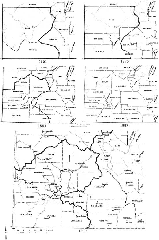
| Montrose District map illustrating the formation of southwestern Colorado's counties. (click on image for a PDF version) |
|
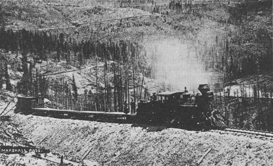
| Denver and Rio Grande work train on the westside of Marshall Pass. Colorado Historical Society |
The most successful freighter in southwestern Colorado was Dave Wood. Entering the business at Gunnison in 1881, when the D&RG made him their "forwarding and commission merchant", Wood freighted supplies west to construction gangs and newly-settled towns from the railroad's end-of-the-line. When the D&RG built its narrow gauge line through the Black Canyon and over Cerro Summit into Montrose, Wood took his business to that town. Montrose would be his largest and most permanent base, and for five years he was the exclusive agent for all freight going to Ouray, Telluride, and Rico. [11] The D&RG extension, built from Montrose to Ouray in 1887, forced Wood to again move his base of operations. From his new location at Ridgway, he did a large freighting business into Telluride and Norwood. The completion of the Rio Grande Southern in 1891 ended Wood's operations. Built in 1882, the famous Dave Wood Road between Montrose and Telluride, via Horsefly Mesa, ran on the west side of the Uncompahgre River parallel with the present highway from Montrose to Ouray, and is today identified by a U. S. Forest Service marker. [12]
Stage line operators, as did freighting outfits, arranged their schedules and bases of operation in accordance with the advancing railroad. Quick to see the advantage of end-of-the-line staging were Bradley Barlow and Jared Sanderson. Even before the entrance of the D&RG and the DSP&P into southwestern Colorado, Barlow and Sanderson stages ran from Chama, New Mexico to Pagosa Springs, Durango, Animas City, and Silverton. As soon as Otto Mears had completed his Marshall Pass Toll Road, stages ran to Gunnison, Crested Butte, Irwin, and Gothic. Railroad expansion in 1881 and 1882 forced the Sanderson company's coaches higher into the San Juans and onto the Uncompahgre Plateau. Stages provided service from Gunnison to newly settled Montrose, where the company's stage barn was one of the early frame buildings. The fare for the rugged trip was $16.50 one way, with each passenger allowed fifty pounds of baggage. [13] Between 1882 and 1890, moving south from Ridgway, Sanderson coaches ran to Placerville, San Miguel City, Telluride, Ophir, and Rico. As had been the case with Dave Wood's freighting business, the completion of the Rio Grande Southern Railroad brought an end to the Barlow and Sanderson Stage line. By 1900, except for the few operations in areas where the railroads did not run, the day of the large-scale wagon freighting business and the stage coach had given way to more modern forms of transportation.
The extension of railroads during the 1880's and 1890's into southwestern Colorado mirrored similar developments in the Central Rockies and eastern Colorado. The last two decades of the nineteenth century witnessed the remarkable expansion and consolidation of American industry. With the rail lines that reached into southwestern Colorado came many of the characteristics associated with this national phenomena. Directed primarily at the region's growing mining industry, the entrance of investment capital, industrialization, and scientific innovation gave rise to a period of growth and transition.
With more efficient and less expensive forms of transportation, larger quantities of ore could be shipped, and the machinery to process that ore could be more easily imported to the mining centers of the region. At the same time railroads facilitated ore production, scientific advances improved mining techniques. The introduction of hydro-electric power to light mines and mills, and the use of electricity to operate power drills, dramatically altered the nature of the mining industry. Geologic expertise was utilized to locate and identify types and quantities of ore. A more complete understanding of chemistry and geology prompted the introduction of revolutionary reduction processes, whereby base metals could be more easily separated from complex ore bodies.
Mining companies, financed by Colorado, eastern, and European investors, spent millions of dollars in the construction of mine shafts, tunnels, underground railroads, smelters, and reduction plants. Big money brought big business. The advent of high-finance, geologic expertise, and industrialization gradually ended the era of the wandering prospector and the small-time owner. Many of these mining frontier pioneers left southwestern Colorado in search of the "virgin vein", but some remained, becoming miners for the larger companies. Joined by other emigrating Americans and large numbers of European immigrants, the wage-earning miners and millworkers constituted a substantial labor force in the late nineteenth and early twentieth centuries. Working conditions were often primitive and dangerous, and pay was low. Like other wage earners in America at this time, both hard-rock and coal miners organized labor unions to demand higher wages and improved working conditions. Unions like the Western Federation of Miners (WFM) and the United Mine Workers (UMW) made known their grievances. Town authorities and company officials resisted union activity, thus prompting confrontation and violence.
The types of ores mined during this period also changed. The price of silver declined after 1873, and finally by 1893, the market for that metal completely collapsed when the government discontinued its policy of purchasing silver for currency production. By 1900, markets for lead, copper, and zinc increased because of the general expansion of American industry and the appearance of wholly new demands, such as copper for electrical wiring and lead for automobiles and other products. Industrial demands also accounted for the growth of coal mining in southwestern Colorado. By the turn of the century, this industry replaced gold, silver, and other base metal mining as the largest producer. In 1898, discoveries in the Paradox Valley of carnotite ore, from which uranium is milled, provided a stimulus for growth in that previously underdeveloped region.
During the period from 1881 to 1920, due to improvements such as railroad transportation, the discovery of new ore processing methods, and the entrance of major capital investment, mining in southwestern Colorado went through numerous changes. Even by 1900, the industry showed little resemblance to its nineteenth century predecessor; its history clearly reflects this transition.
The southwestern Colorado mining boom that occurred in the late 1870's carried over into the eighties, and in the period prior to 1893, the region reached its peak in silver production. Considerable activity took place in the Tin Cup, Pitkin, Gothic, and Tomichi Mining Districts in the Gunnison country. With a few notable exceptions during this period, the San Juan mines produced ores in which silver and lead predominated. The mines in or near such towns as Lake City, Silverton, Ouray, Rico, and Telluride continued and expanded their silver mining operations. By 1881, the Virginius Mine, at the head of Canyon Creek near Ouray, was worked in three underground levels on two main shafts. In 1881, rich deposits between Red Mountain and Ironton in Ouray County were discovered, and in 1882 and 1883, prospectors swarmed into this new field. [14] By 1890, a great deal of mining activity west of Lake City took place at the head of Henson Creek on Engineer Mountain, where the Polar Star, Ben Butler, and Frank Hough mines were worked. Silver mined from this area was treated at the fifteen-stamp Palmetto mill, located at the confluence of Henson Creek and Palmetto Gulch. [15]
Until the early 1890's, there was nominal gold production in southwestern Colorado. Collected only from the most accessible areas, placer gold was panned or mined using hydraulic methods; the loosening of surface gold deposits by intense water pressure. Placer gold mining accounted for only $188,635 in San Miguel County, (first in gold lode mining production in southwestern Colorado and third in the state) during the period from 1878 to 1924. [16] Yet, one such placer mining project stands out in the history of the San Miguel River basin. Financed by a St. Louis company, the Montrose Placer Mining Company in 1889, bought six and one-half miles of mining claims at Mesa Creek Flats, situated along the Dolores River, four miles below its juncture with the San Miguel River. To placer mine the area by hydraulic means, the company found it necessary to bring water from the San Miguel River, twelve miles away, and carry it by ditch and flume the entire distance. The "San Miguel Flume", eight miles of which ran along the northern wall of the San Miguel Canyon, was supported on brackets along the side of perpendicular cliffs and ranged from 100 to 150 feet above the river and from 250 to 500 feet below the summit of the gorge. It extended about one-and-a-half miles on the sandstone cliffs above the San Miguel River and some six-and-one-half miles on the canyon wall above the Dolores River: At a cost of about $100,000 and using 1,800,000 feet of lumber, the San Miguel Flume was completed early in the summer of 1891. This remarkable engineering achievement proved however, to be a less than satisfactory device in placer mining. The "leaf gold" in Mesa Creek Flats was so fine that it was impossible to recover when run through sluice boxes under pressure. Despite the immediate abandonment of the operation after 1891, remnants of the San Miguel Hanging Flume are still in evidence on the canyon walls near present-day Uravan. [17]
The general failure of placer operations in southwestern Colorado did not exclude the possibilities for gold lode mining. Prior to 1900, mining technology had used the cyanide process, a method whereby gold or silver could be more easily separated from low grade ores, or those with a low percentage of valuable metals. Simply stated, the cyanidation process involved treating finely crushed gold bearing ores with solutions of sodium or potassium cyanide. The solution, in which the gold dissolved, was deposited upon zinc or copper plates, where the valuable metal precipitated. With this process, gold producers could recover profit from previously discarded ores. Shipment of low grade ores to modern processing plants was made feasible by the availability of railroad transportation. A third explanation for the advance of gold mining in the mid-1890's was the collapse of silver prices brought on by the Depression of 1893. In many cases, areas where silver had been extensively mined saw renewed mining activity on the basis of new gold discoveries. These were areas where new mining technology was most often applied and where railroad routes had been previously constructed.
In the period following 1895, gold mining was centered primarily in the established centers of San Miguel, San Juan, and Ouray Counties. In the five years from 1897 to 1901, gold production of these counties alone approximated $20 million, or one-sixth of the entire State's output for those years. From 1898 the significant gold mining operations of southwestern Colorado were located mainly in the Telluride District of San Miguel County, and came from the mines of three major companies, the Tomboy Gold Mines Company, the Liberty Bell Gold Mining Company, and the Smuggler Union Mining Company. The gold-bearing veins of the Liberty Bell mine were discovered as early as 1876, but the property was allowed to sit idle due to difficult terrain, production costs, and transportation rates. In 1897, the mine was purchased by the U. S. & British Columbia Mining Company, and from 1898 to 1920, the firm's production from the Liberty Bell and adjacent properties was valued at close to $16 million. The Tomboy Gold Mines Company, incorporated in 1899, showed similar success. From 1899 to 1920, its gold production reached close to $19 million. Although the majority of operations were located in the San Juan region, the Gunnison country mines did show some gold production during this period. In Gunnison County considerable gold was mined in the Ohio City and Pitkin areas, particularly around the Gold Links Mine in the Gold Brick (or Ohio City) Mining District. Southwest of Gunnison, in the Domingo District, the Vulcan and Good Hope mines were large producers at this time. [18]
The decline of silver production in the mid-1890's and the subsequent emphasis on gold mining created numerous personal hardships, businesses went under, and several towns famous for their silver mines were deserted. For some however, this change caused renewed success. No better example of the transition was that of Thomas F. Walsh's Camp Bird mine. Located above Ouray in the Imogene Basin, the mine was originally discovered by William Weston in 1877. Following four years of only marginal silver production, Weston abandoned the Una and Gertrude mines. The property remained idle for fifteen years, but attracted the attention of Thomas Walsh. At that time, Walsh owned and operated a smelter in Ouray, and his initial interest in the Una and Gertrude rested in the availability of suitable fluxes* for use at his smelter. In examining the dump piles at the Gertrude mine, Walsh discovered ore rich in quartz-gold. When ore samples were assayed, values ran as high as $3,000 per ton. [19] Walsh immediately set out to acquire the abandoned claims and surrounding land. In the four years following the 1896 purchase, Walsh's property, renamed Camp Bird, included 103 mining claims, twelve mill sites, and covered over 900 acres. Appraised in July, 1900 at $6,000,000, the Camp Bird mine had, by that time, yielded $2,535,512 gross and a profit of $1,650,000. Walsh sold the Camp Bird in 1902 to a British syndicate for an estimated $5,200,000, and from that date to 1916, the Camp Bird (Ltd.) produced $21,884,894 in gold. [20] Despite the tremendous profits of the Camp Bird property under British supervision, the fascination surrounding the mine's history belongs with Walsh's ownership. In less than a decade, from near bankruptcy following the Silver Crash of 1893 to 1902, Thomas Walsh became a multimillionaire. Walsh's former home, in the mining-ghost-town of Animas Forks and the library in Ouray, which bears his name, are present-day reminders of an uncommonly successful mining career.
*Fluxes are ores or other materials used in the process of removing undesirable substances like dirt or sand from a molten mixture.
Probably the most important single factor in the development of gold mining and the mining industry in general during the 1890's was the use of new ore reduction processes. The smelting and milling of low-grade and complex ores, during the last decade and one-half of the nineteenth century, increased in importance as efficient reduction methods meant the difference between profit and loss for many mining operations. The location of railroad routes and shipping points in proximity to successful mining regions facilitated the transportation of ore and promoted the growth of localized milling and smelting industries.
William Palmer's D&RG Railroad was built to the San Juans in 1881 with the intention of capturing the region's ore transportation market. Palmer and English financier, William Bell took this goal one step further. Viewing the strategic location of Durango in relation to the Silverton mining district, the idea of building a smelter in Durango was contemplated even before the railroad reached its final destination. The fact that Palmer's road would carry large quantities of ore, much of which was to be extracted from mines in which he had an interest, combined with the availability of coal from mines at Crested Butte and near Durango and presented an excellent opportunity for the smelter business in Durango. In the summer of 1880, Palmer and Bell incorporated the San Juan and New York Smelting Company, and immediately acquired the Silverton smelting works owned by George Greene and Company. [21] In addition to the Silverton plant, Palmer and his associates purchased a limestone quarry, and several coal mines near Durango. Palmer's group wanted the enterprise to own everything required for reduction except the ores which would come from the entire San Juan country. Converting the Silverton facility into a sampling works where ores could be evaluated before shipment, the San Juan and New York Smelter was relocated at Durango in 1882.
Because of the relative isolation and slow development of the smelting industry in southwestern Colorado, mountain smelters that had been erected before the Durango plant remained in business longer than their counterparts in the Central Rockies. At Lake City, the firm of Crooke Brothers and its successor, the Crooke Mining and Smelting Company Ltd., operated until the mid-1880's. At Rico, the Grand View Smelting Company and the Pasadena Mining and Smelting Company went into business about 1880 and operated until the latter part of the decade. [22] In addition to these plants, short-lived smelters were erected at Tin Cup and just west of Ophir at Ames during the early 1880's. From 1888 to 1890, the San Juan and New York Smelting Company improved its plant at Durango, installed new roasting ovens, and enlarged and modernized its blast furnaces. As a result of these innovations, the smaller mountain smelters could no longer compete with the newer facilities due to increasingly low prices returned for silver and higher reduction costs.
The middle and late 1890's were not prosperous times for the smelting industry. Declining silver prices following the Silver Crash of 1893 and lower returns for lead ores contributed to narrow profit margins for producers and processors alike. In April, 1895, the Directors of the San Juan and New York plant in Durango were faced with the realities of decreased revenues, and leased the property to the Omaha and Grant Smelting Company of Denver. By 1899, as continued low silver prices stunted further development and as the nationwide industrial consolidation movement swept over the smelting business, the Omaha and Grant operations became part of the American Smelting and Refining Company. The formation of this quasi-monopoly in smelting typified the patterns and trends of big business during the "Gilded Age".
Smelters in southwestern Colorado prospered during the 1880's and early 1890's when the high country mines produced large quantities of relatively rich ores. For years these smelters processed more than one-half of the State's output of precious and base metals. [23] When silver prices fell and attention was turned to gold and other base metal production in the late 1890's and early 1900's, the smelting business suffered. The development of metallurgical techniques and the consolidation of many large producing mines in the San Juan region through syndication combined to promote less dependency on the Durango operations. The new reduction processes, such as cyanidation, concentration, and amalgamation*, were incorporated into the operations of the large mining and milling companies. Increased production and treatment of lower grade ores locally, gradually superseded the necessity for smelter shipments. Rather than transport minerals to the Durango smelter, mining companies brought the reduction process to the mines during the years following the turn of the century.
*The concentration method is one in which minerals are separated and accumulated from useless ore bodies through crushing and the application of intense heat. The amalgamation process involves suspending ore concentrates in water and then passing the separated materials over a surface of liquid mercury. The amalgam, or mercury-gold substance, is subjected to intense heat from where the gold is recovered.
The Smuggler Union, the Tomboy, and the Liberty Bell Mills in the Telluride District were by 1899 utilizing concentration methods in the milling of low grade ores, the Liberty Bell adding a seven-ton cyanidation plant to its eighty-stamp amalgamation mill. In Dolores County, zinc mining increased dramatically following 1898. In that year zinc production jumped to 200 tons from the fifteen tons mined in the previous year. In 1901, many of the mines in the Rico District were consolidated under the name of the United Rico Mining Company, and three concentration mills used in lead and zinc production were erected. In 1901, the cyanidation process was added to the Camp Bird and Smuggler Union operations. In 1904, machines were added to the Silverledge Mill at Chatanooga in the Red Mountain District so as to separate iron from the lead-zinc-iron ore, making this mill the first in San Juan County in which zinc was recovered as a marketable product. In 1908, due to a decline in zinc and lead prices, mineral production fell off for approximately five years until new technology and increased demands brought on by World War I, revitalized the copper, lead, and zinc industries. From 1915 to 1920, the mining industry in southwestern Colorado saw a brief resurgence when the value of all metals produced rose thirty per cent, due to the increased production of zinc. The Ute and Ulay Mines outside Lake City produced considerable low grade ore containing large quantities of zinc-blende. The Black Bear mine near Telluride produced complex lead-zinc-copper-iron-silver-gold ore in 1915, and from that time to 1920, a large percentage of San Miguel County's mineral output was obtained from the Smuggler Union Mill's treatment of ore received from the Black Bear. The Yankee Girl and Guston mines in the Red Mountain District, owing to the increase in copper and lead prices, saw a brief revival from 1915 to 1918 after experiencing previous inactivity.
New milling methods, undertaken in order to recover larger quantities of low grade ore, caused the smelting industry to suffer from the mid-1890's well into the twentieth century. By 1920, the Durango plant, one of only two American Smelting and Refining Company facilities remaining in the state, was working at low capacity, with rarely more than one furnace in blast at any given time. The smelter served a few mines at Telluride and other towns in the San Juan country, but when the severe economic dislocation of the Great Depression shut down these mining operations, the Durango plant also failed and was permanently closed in 1930. [24]
Further developments in mining technology supplemented the industry's growth in the 1890's and the early 1900's. Improved facilities for the transportation of ore from mines to mills was provided by wire-rope trains. Guided by large wooden supports, wire cables carried ore cars and at times miners from mine to millsite, replacing the slower burros. A wooden tram-support network, used to transport ore from the Tobasco Mine to the Tobasco Mill, is still in evidence on Cinnamon Pass. Of greater importance to the development of mining efficiency was the introduction of electric power. The history of mining in southwestern Colorado during the last part of the nineteenth century and the first decade of the twentieth runs parallel to the development of hydro and steam power plants, and their application to the mines of the region.
In 1890, a hydroelectric plant was installed four miles below the Caroline mine near Mount Sneffels on Canyon Creek. The experiment of using a tension of 900 volts higher than had ever been used in that kind of work was adopted, and from the Revenue Tunnel Plant Number Two, power lines were run into the mine to supply power to the electric motors and drills. [25] During the winter of 1890 and 1891, L. L. Nunn, owner of the Gold King mine, constructed a hydroelectric plant below his mine at the junction of the Lake and Howard Forks of the San Miguel River, just west of Ophir. Using an experimental Westinghouse generator, the Ames Power Plant was one of the first in the country to generate high voltage alternating current for commercial purposes. [26] The current was generated 2.6 miles to the Gold King mine where it powered a 100-horsepower electric motor which was in turn, belted to a 40-stamp mill. In 1896, the plant was rebuilt with two-phase equipment, operated at 11,000 volts, and the transmission line was extended across the mountains seventeen miles to the Camp Bird operation. The Bridal Veil Powerhouse, built above Bridal Veil Falls outside Telluride in 1907, provided power by alternating current to light the Smuggler Union mine and to run its mill. A portion of the water needed to run the generator was carried by flume to the facility from Blue Lake, 3,000 feet above and four miles away from the plant. Power was then transmitted to the mines 2,000 feet below. The powerhouse remained in operation until 1953 when the Idarado Mining Company found it cheaper to purchase electricity from the coal-fired plants of the San Miguel Electric Association. [27]
By 1906, the Animas Power Company had completed its hydroelectric plant at Rockwood above Durango, and from that year on it furnished electric power to the neighboring mines. The Western Colorado Power Company, a subsidiary of the Utah Power and Light Company, was formed in 1913 out of the existing systems at Durango and Telluride. The Durango plant, a reserve steam system, was in operation as early as 1886. [28] Serving Durango, Telluride, Montrose, Delta, Ouray, and Silverton, Western Colorado Power furnished practically all of the power requirements for mining operations in southwestern Colorado.
The improvement of ore reduction technologies and the development of industry in Colorado brought with them a need for increased amounts of fossil fuel. From these demands, at the turn of the century, grew a booming Colorado coal business. The first coal mining however, came with the entrance of the Denver and Rio Grande and Denver South Park and Pacific Railroads in the early 1880's. The construction of railroad lines in southwestern Colorado during the 1880's and 1890's was determined by the desire to connect gold and silver mining camps with the rest of the state, but was also motivated by the necessity of securing locomotive fuel from the many rich coal fields in the area.
The largest and most productive coal region in southwestern Colorado was the Uintah Field. Located in northern Gunnison County and in portions of eastern Montrose, Delta, and Mesa Counties, the Uintah Field is composed of three major coal mining centers located in Gunnison County. First discovered in 1879, the Crested Butte coal fields developed rapidly after 1881 when the D&RG built to the town of Crested Butte. The Crested Butte mines, opened by the railroad in 1884, were worked primarily to supply bituminous coal* to the Colorado Coal and Iron Company plant at Pueblo. [29] In 1900, the mine produced its greatest output, 285,889 tons, and employed its largest work force of 326 people. From its first year of operation in 1884, the progress or decline of the Crested Butte mines determined the subsequent fortunes of the town of Crested Butte until 1952, when the mines were closed. Located just north and slightly west of Crested Butte is one of the few anthracite coal* fields found in the State. Located on the Slate River, the Anthracite or Mesa mine (renamed the Smith Hill mine in 1914) was opened in 1882. In 1892, the mine produced 80,182 tons of anthracite coal, and employed 175 people. Connected with Crested Butte by a D&RG branch line in 1893, the Mesa mine continued production until 1907 when it was closed. Coal deposits on Ohio Creek, in the Mount Carbon field, were discovered by Sylvester Richardson in 1880. By 1883, the townsites of Baldwin and Castleton grew up as these deposits were worked by the Union Coal Company of Denver. That company's affiliation with the Denver, South Park and Pacific Railroad prompted the building of a branch line, north from Gunnison, up Ohio Creek, into these towns and their nearby coal mines. The first operations at the Baldwin mine were short-lived as its highest annual production of 52,892 tons was achieved in 1889. In April of 1893, the mine was closed. The Floresta or Ruby mine, north of Baldwin on Kebler Pass in the Floresta field, was opened in 1893. In that year, the mine was connected with Crested Butte by another D&RG branch line. The Floresta coal mine, a large producer in its own right, was noted for the fact that it was located at a higher elevation than any other coal mine in the United States, and ranked second in the world for this category. Before closing in 1919, the Floresta mine achieved its largest output in 1910, when 68,980 tons of coal were mined. The fourth division of the Uintah Field, the Grand Mesa field, begins around Somerset, in western Gunnison County, near Paonia in Delta County, and extends to near Palisade in Mesa County. The largest of the Grand Mesa mines in southwestern Colorado was located at Somerset. First operated in 1903, the mine was soon connected to the nearby markets at Paonia, Hotchkiss, Cedaredge, and Delta when the Denver and Rio Grande Railroad built up the North Fork of the Gunnison River valley. By 1910, the mine's production was 250,568 tons, which surpassed the Crested Butte mine's output for that year by more than twofold. After a 337,542 ton-year in 1917, production fell off by 1920, when 286,586 tons were mined. During the first quarter of the twentieth century, the Somerset mine was a consistent producer, supplying coal to such towns as Montrose and Grand Junction. [30]
*The difference between the various types of coal is determined by the percentage of fixed carbon content. Anthracite coal has a higher percentage than bituminous. subbituminous coal has less carbon content than bituminous, but more than lignite coal.
The second major coal field in southwestern Colorado, the San Juan or La Plata Field, extends westward from near Pagosa Springs through La Plata, Montezuma, and portions of Dolores and San Miguel Counties. The largest production came from La Plata County, where the coal mines in the vicinity of Durango supplied the fuel needs of the Denver and Rio Grande Railroad and the nearby mining operations. The Hesperus, Ute, and San Juan mines were large producers during the 1890's. La Plata County's coal production in 1900 was 438,563 tons, while in 1910, the county's mines produced 664,069 tons of coal and employed 715 people. [31]
The Tongue Mesa Field, located in the common corner of Montrose, Ouray, and Gunnison Counties, covers about forty square miles, and its coal reserve has been estimated at 840 million tons. [32] Little mining was done in this field during the 1890's and early 1900's since the coal was subbituminous, and no immediate railroad connection was made to the field. Production was limited entirely to local demand, and the greatest part of this was consumed at Montrose, about ten miles north of the field. [33]
The southwestern Colorado coal industry in the late 1880's and 1890's was totally dependent on the railroads that consumed its output and linked its mines to local and outside markets. The collapse of the silver mining industry after 1893 affected all areas of mining and transportation, yet coal mining fairly well held its own. The D&RG's heaviest traffic during the mid-1890's was in coke and coal, eighty percent of which was carried outside of the state for sale. [34] Through continual production and development, coal mining, while still associated with the railroads, began to prosper on its own by the turn of the century thanks to increasing industrialization in the State and region. The fact that much of southwest Colorado's coal was of high quality aided in the expansion of the industry at this time. For example, from 1894 to 1900, Gunnison County's coal mining increased from 200,325 to 432,555 tons, while La Plata County's production grew from 53,571 to 123,524 tons. In 1900, Gunnison County ranked fifth and La Plata County seventh in Colorado coal production. [35]
|
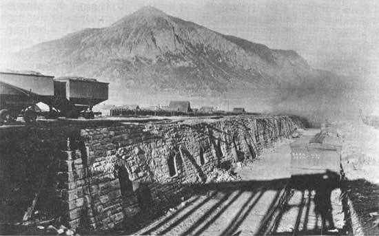
| Coke Ovens at Crested Butte. Denver Public Library, Western History Division |
|
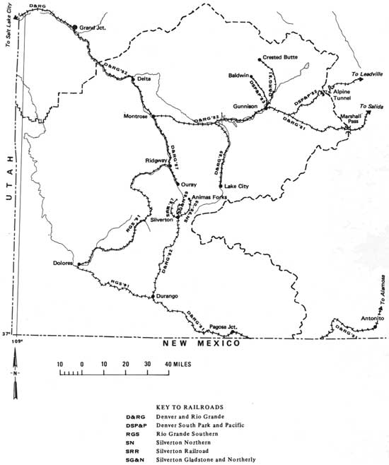
| Montrose District map of the major railroad construction in southwestern Colorado (1881-1905) (click on image for a PDF version) |
The growth of the coal mining industry in southwestern Colorado can also be accounted for in the development of the coke industry*. Smelters and newly erected reduction centers demanded fuel with which to heat their ovens, and the major coal producing areas readily supplied their needs. The three major coke producing areas in southwestern Colorado were in Crested Butte, Durango, and Rico. During the mid-1880's, coke was produced near Rico, where some of the earliest toll roads in Dolores County were used to transport coking coal from the mines near the town to the coke ovens a few miles to the north. When the Rio Grande Southern Railroad built its line along that route in 1891, the site between Rico and Ophir was formally named Coke Oven. [36] The Durango mines produced coking coal, but by far the largest producers were the fields located near Crested Butte. By 1917, due to the decline of mining in general, the coke industry had all but closed in the region, with the exception of the Crested Butte ovens, which remained open until the end of the decade.
*Coke is most commonly derived from a process whereby the volatile constituents of bituminous coal are driven off by heat, and the fixed carbon and ash components are driven together. The important quality of coke is the intense heat it creates when burned.
As hard rock mining declined from 1917 to 1920, the coal industry actually expanded, and by 1920 surpassed silver and gold in value of production. Gunnison County remained the largest producer in southwestern Colorado, the Somerset Mine in the western portion of the county ranking as one of the main contributors with an average capacity of 1,800 tons per day. [37]
TABLE II
Southwestern Colorado Coal Production (In Short Tons)
1916-1919*
| COUNTY | 1916 | 1917 | 1918 | 1919 |
| Delta | 76,986 | 102,248 | 94,870 | 88,682 |
| Gunnison | 511,755 | 653,233 | 651,995 | 472,735 |
| La Plata | 111,406 | 138,523 | 141,040 | 116,509 |
| Montezuma | 2,855 | 1,600 | 1,927 | 2,262 |
| Montrose | 922 | 1,684 | 1,020 | 1,856 |
| Ouray | --- | 1,129 | 641 | 227 |
| State Total | 10,522,185 | 12,515,305 | 12,658,055 | 10,406,543 |
*The above data was compiled from the Yearbook of the State of Colorado, 1918-1 920. [38]
Consolidation and industrialization of the southwestern Colorado mining industry at the turn of the century did not come without attendant costs. From the human perspective, the modernization of the industry through the advance of technology brought with it a struggle between labor and management. The growth of unions in the 1890's was the response of laboring men to the increasing constriction of opportunities in Colorado industry, low wages, long hours, and poor working conditions. Much of the political strength of organized labor that rose to address these grievances came from the growth of the Western Federation of Miners (WFM). In Colorado the growth of the WFM had been particularly noticeable in the decade from 1893 to 1903. Representatives from Aspen, Creede, Ouray, and Rico helped found the organization in 1893, and Colorado's miners continued to be its leaders. As early as 1896, Colorado's Bureau of Labor Statistics reported that the WFM had chartered locals in both coal and metalliferous camps and estimated that their membership included at least fifty percent of all miners in the state.
The WFM's reputation for lawlessness and violence originated in its initial encounter with mine owners in the Cripple Creek District during early 1894. The union's subsequent strikes enhanced this image, yet in all cases, both sides bore equal responsibility for disorders. In March, 1899, the WFM local at Henson, three miles west of Lake City, struck the Hidden Treasure and the Ute and Ulay mines when the owners demanded that unmarried employees live in the company's boarding houses. Early in the strike armed miners seized the mines and retained possession until state troops restored the property to the owners.
The most significant labor dispute in southwestern Colorado occurred in the Telluride mining district. Until 1899, the prevailing wage in the district's mines had been $3 for an eight-hour day, but when the Smuggler Union mine was acquired by Boston capitalists, its manager, Arthur L. Collins, instituted the "fathom" (or contract) system where the quantity of ore mined and not the hours spent in the mine, determined the work day.
Dissatisfaction with the fathom system, which was foreign to the mining camps of Colorado, increased until on May 2, 1910, Miners' Union Number 63 struck the Smuggler Union over the question of how labor was to be employed in the district. Flatly refusing to negotiate, Collins reopened the mine on June 17 with nonunion labor hired at terms denied the strikers. Clearly, the labor question at the Smuggler Union was not one of wages or hours, but of union recognition. Union members interpreted Collins' strikebreaking tactics as an attempt to destroy their organization. The dispute climaxed on July 3, 1910, when about 250 heavily-armed strikers surrounded the Smuggler Union properties. Negotiations for a settlement between strikers and strikebreakers degenerated into a morning-long battle in which three men were killed and six were wounded. The strikebreakers surrendered and nearly 100 of their number were forcibly removed from Telluride. On July 6, an agreement between the disputing factions was arranged wherein a $3-eight-hour-day clause was included in a union contract with all the companies of the district. The strike however, had divided the mining camps and the town of Telluride into pro-union and anti-union forces. Reconciliation of any sort became impossible when on November 19, 1902, Arthur Collins was murdered by an unknown assassin. Anti-union fears and hatred, enhanced by the intransigent Telluride Mining Association, led the business community to conclude that the WFM should be destroyed. Their chance came in the late summer of 1903. [39]
In part, the renewal of trouble in Telluride was the result of a general drive by labor to force improved working conditions throughout Colorado industry during 1903 and 1904. Although Telluride's miners won the eight-hour day in 1901, mill workers had been excluded from contract negotiations. To obtain equitable employment conditions, on September 1, 1903, approximately 100 millmen from the Smuggler Union walked off their jobs, forcing six mills to close. Immediately the Liberty Bell, Tomboy, and Nellie mines shut down, bringing to a virtual standstill all mining activity in the district. Reacting to the walkout, citizens, businessmen, and mine owners alike quickly formed the Telluride Citizens' Alliance (TCA), part of a national employers' movement, whose goal was the destruction of the WFM. Mine owners, with the backing of the TCA planned to reopen the mines with nonunion labor, but were fearful that violence, like that which had occurred in 1901, would result. State and military intervention was requested, and after considerable deliberation, Governor James H. Peabody, on November 20, 1903, ordered Major Zeph T. Hill and his command to Telluride to insure peace. Hill, in assuming command of Telluride by January, 1904, proceeded to "clean out" the town of activists and union members. Essentially imposing martial law, Hill had deported to Montrose and Ridgway, close to 100 strikers by February. Violence threatened when it was announced that these banished miners would return to Telluride from Ouray escorted by fifty armed union men. On April 8, 1904, seven union leaders led approximately sixty of the deported miners back to Telluride. Anti-union forces met the train, arrested the sixty-seven men, and promptly deported them again. Although strikers refrained from violence, their efforts did not result in union recognition. The mines and mills ran with nonunion labor and anti-unionism clearly ran the mining district. Throughout July and August, civil authorities continued to banish "undesirables", yet by December mine owners conceded the $3-eight-hour-day to all its employees. The union's calling off the strike did not alter the mine owners' determination never to hire a member of the WFM however. Few, if any, known WFM members found employment in the district. For anti-union forces, the mauling of the WFM in Telluride represented a clearcut victory by management over southwestern Colorado miners. [40]
As science and technology provided several necessary steps in the growth of southwestern Colorado's mining industry during the years from 1881 to 1920, so too did mining aid in the development of technology and science. Two of the region's numerous ore and stone deposits played a part in the construction of important state and national buildings.
Southwestern Colorado provided a fair share of building stone, granite being the most significant non-precious mineral. Although some granite was quarried near Durango, the most important granite field was in Gunnison County, at Aberdeen. Located four miles up Beaver Creek, about five and one-half miles from the abandoned railroad site of Hierro, and six miles west of Gunnison, the granite mines were part of an 1890 placer claim that included 120 acres. The mines were first worked in 1889 when the firm of Gettis and Scerie removed stone for the building of the State Capital. In 1905, stone was quarried for the State Capital steps, and from 1911 to 1912, large amounts of stone were taken out in order to build the State Museum in Denver. Gunnison County was also famous for its marble quarries on Yule and Crystal Creeks, near the town of Marble. One of the first buildings to be constructed from Yule marble was the United States Post Office in Denver. Lincoln Memorial, the Tomb of the Unknown Soldier, Union Station in Denver, the Federal Reserve Bank, Colorado National Bank, and the United States Customs Building were constructed with stone taken from the Marble quarry. By 1941, its resources depleted, the quarry shut down its operations, never to reopen. [41]
One of the major developments in southwestern Colorado mining was in the carnotite, uranium, and vanadium industries. The Colorado portion of the large carnotite region in the American southwest is bounded on the west by the Colorado/Utah line, on the north by the Uncompahgre Plateau, on the east by the San Juan Mountains, and on the south by McElmo Creek. [42] Located in the area comprising western Montrose, San Miguel, and Dolores Counties, carnotite mining was first taken up in the Paradox and Gypsum Valleys. Although radium was not discovered in Paradox until 1898, carnotite, the soft yellow ore from which uranium is processed was attracting the attention of Paradox valley pioneers as early as 1881, when the Talbert brothers sank a shaft into the yellow material while in search of gold and silver on Roe Creek. This claim, which showed no potential for precious metal was abandoned, but in later years it became part of the Copper Prince mine near Uravan from which carnotite ore was extracted.
In the spring of 1898, a sample of carnotite was sent by Gordon Kimball of Ouray to the French chemist, Charles Poulet, who was then in Denver. Poulet found the sample to be rich in uranium. This radioactive ore, one of the first of its kind to be found in the world, was used in the discovery of radium, and between 1898 and 1928, ores taken from the Uravan region accounted for almost one-half of the world's production. The existent towns of Nucla, Bedrock, and Naturita underwent considerable growth when reduction plants were established between the Paradox Valley and Naturita by Standard Chemical, the Radium Company of Colorado, and General Vanadium Company. Radium ore, with an estimated value of $1,100,000 was produced in the southwestern Colorado counties alone in 1919. H. E. Bishop, manager of the Radium Company of Colorado estimated in 1923 that ninety percent of the 150 grams of radium used in the United States came from the Colorado and Utah carnotite regions. With the discovery and production of Belgian Congo radium ore in 1923, demand for carnotite mined in southwestern Colorado fell off sharply. As a result, population decreased in the Paradox Valley although production continued on a small scale. By 1933, Bedrock was quiet, claims had been deserted, and the Yellow Bird, Monogram, Thunderbolt, and Jo Dandy carnotite camps were but memories. [43]
In 1915, the vanadium phase of carnotite mining began. Lasting through World War II, vanadium mined in Colorado accounted for eighty-five to ninety percent of world production. Vanadium, a rare metal used as an alloy in the strengthening of steel and iron, was mined chiefly by the Primos Chemical Company and the General Vanadium Company, The Primos Company obtained most of its ores along Bear Creek in San Miguel County, while the General Vanadium Company worked deposits on the north side of the San Miguel River between Sawpit and Placerville, and along both sides of Leopard Creek between Placerville and Brown. [44] The only large vanadium mill in the state was located at Vanadium, eight miles west of Telluride. During the later stages of vanadium mining, most of the work was done by the Vanadium Corporation of America, which had bought out the other companies. Radium, sodium uranate, uranium nitrate, and various vanadium compounds were mined on a small scale along the Dolores River after 1920. The most recent stage of carnotite production includes uranium mining for nuclear power; this development, along with continued vanadium mining, affected the use and occupation of the Paradox Valley during the early 1950's.
Moving toward modernization and with a need to grow from frontier camps into stable communities, mines and mining towns succeeded or failed in the period after 1881 according to their ability to procure for themselves railroad transportation, agricultural produce, electricity and a modern communications system. [45] The effects of industrial consolidation, a significant change in federal currency programs, and national economic depression caused, by 1920, many individual mining operations and small camps to disappear. The larger towns like Gunnison, Crested Butte, Silverton, Durango, Lake City, and Ouray lost large percentages of their populations. The steady decrease of population in the San Juan country after 1900 is testimony to the fact that mining alone could not support the large numbers once living in the mining "boom" towns. An example of such a population decline is shown for Lake City in Table III. The mining camps in the Gunnison country, as well, showed a decline. Table IV illustrates the manner in which many southwestern Colorado camps, failing to secure railroad transportation, or simply having their mines worked out, ceased to exist. All of the towns except Whitepine, Tin Cup, and Sillsville in the following Table passed from the census between 1910 and 1920, and have never been re-occupied. [46]
TABLE III
Decline in the Population of Lake City
1890-1940*
| YEAR | POPULATION |
| 1890 | 862 |
| 1900 | 1609 |
| 1910 | 646 |
| 1920 | 538 |
| 1930 | 449 |
| 1940 | 349 |
*This table originally appeared in "Social and Economic History of Southwestern Colorado, 1860-1948", by D. H. Cummins (Ph.D. Thesis: University of Texas, 1951), p. 238.
TABLE IV
Early Towns of Gunnison County That Have Ceased to Exist**
| TOWN | 1890 | 1900 | 1910 |
| Allen | -- | -- | 101 |
| Castleton | 63 | 322 | 351 |
| Crystal | 88 | 101 | 4 |
| Dorchester | -- | -- | 33 |
| Gothic | 48 | 50 | 0 |
| Howeville | -- | 300 | 119 |
| Irwin | 45 | 264 | 56 |
| Kezar | 28 | 83 | 111 |
| Sillsville | 189 | 194 | 45 |
| Spencer | 49 | 88 | 39 |
| Tin Cup | 209 | 264 | 56 |
| Vulcan | -- | 93 | 38 |
| Waunita | 65 | 150 | 27 |
| Whitepine | 237 | 322 | 35 |
**Twelfth Census of the U. S. (1890), I, Population, Part I, p. 440; Thirteenth Census (1910), II, Population, pp. 207-208. This table originally appeared in "Social and Economic History of Southwestern Colorado, 1860-1948", by D. H. Cummins (Ph.D. Thesis: University of Texas, 1951), p. 530.
The diversification of the mining industry at the turn of the century, facilitated by the coming of the railroads, was symbolic of a larger trend in southwestern Colorado during the years from 1881 to 1920. As interest and productivity in mining waned during the early years of the twentieth century, attention was directed to other areas of economic life. Southwestern Colorado was more than a mineral resource frontier, and the men and women who came to the region after 1881 made use of fertile river bottoms and high country grazing lands. The development of ranching and agricultural production in the period from 1881 to 1920 opened a new era of land use in southwestern Colorado, one that would have lasting effects on the character of occupation in the region up to present times.
Chapter VIII: Notes
1. Carl Abbott, Colorado; A History of the Centennial State (Boulder: Colorado Associated University Press, 1976), p. 90.
See also: Robert G. Athearn, The Coloradans (Albuquerque: University of New Mexico Press, 1976), p. 125.
2. D. H. Cummins, "Social and Economic History of Southwestern Colorado, 1860-1948" (Ph.D. Thesis: University of Texas, 1951), p. 446.
4. In researching and writing the history of William Jackson Palmer's Rio Grande Western Railroad during its construction phases in southwestern Colorado, the author relied upon the excellent work of Robert G. Athearn, Rebel of the Rockies (New Haven: Yale University Press, 1962).
6. Athearn, Rebel of the Rockies, p. 101.
7. Frank Hall, History of the State of Colorado, Vol IV (Chicago: Blakely Printing Co., 1895), p. 311.
8. Cummins, op. cit., pp. 455-459.
9. For a concise chronology of the career of Otto Mears and southwestern Colorado transportation, much useful information was obtained from the chapters on railroading in Michael D. Kaplan, "Otto Mears: Colorado's Transportation King" (Ph.D. Thesis: University of Colorado, 1975).
See also: Sidney Jocknick, Early Days on the Western Slope of Colorado (Denver: The Carson-Harper Co., 1913), p. 242.
See also: Ridgway Herald, January 7, 1892.
10. Cummins, op. cit., pp. 479, 492.
See also: Wilbur F. Stone, History of Colorado Vol. I (Denver: S. J. Clarke and Co., 1918), p. 381.
11. See: Zeke Scher, "The Man Who Kept the Mining Camps Alive" Denver Post Empire Magazine, April 23, 1973.
See also: Duane Vandenbusche, Early Days in the Gunnison Country (Gunnison: B & B Printers, 1974), p. 117.
12. Wilson Rockwell, Uncompahgre Country (Denver: Sage Books, 1965), p. 79.
13. See: Morris Taylor, "The Barlow and Sanderson Stage Lines in Colorado, 1872-1884", Colorado Magazine (L, No. 2, Spring, 1973).
See also: Ouray Solid Muldoon, March 3, 1882.
14. Cummins, op. cit., p. 479.
See also: S. E. Poet, "The Story of Tin Cup, Colorado", Colorado Magazine (IX, No. 1, January, 1932), pp. 30-38.
15. Charles Henderson, Mining in Colorado (Washington: Government Printing Office, 1926), p. 53.
16. Rockwell, op. cit., p. 160.
See also: Rockwell, op. cit., p. 165.
18. For useful statistics concerned with gold and silver mining and production levels in Colorado from 1858 to 1923 see Henderson, op. cit., pp. 45, 94-96, 224.
See also: William M. Brown, "The History of the Cebolla-Powderhorn Country" (M.A. Thesis: Western State College, 1935), p. 32.
19. Colorado Writers' Project, Colorado; A Guide to the Highest State (New York: Hastings House, 1941), p. 57.
See also: Rockwell, op. cit., p. 238.
20. Several informative newspaper clippings concerned with Thomas Walsh and the Camp Bird mine were found in the Thomas F. Dawson Scrapbooks, "Mining", (Colorado Historical Society, Denver, Colorado): Denver Post, May 4, 1905; Denver Times, January 26, 1912; and the Rocky Mountain News, January 23, 1916.
See also: Henderson, op. cit., pp. 184-185.
21. Thomas A. Rickard, The Development of Colorado's Mining Industry (Denver: The American Institute of Mining Engineers, 1896), p. 9.
See also: LeRoy R. Hafen, Colorado; A Story of the State and Its People (Denver: The Old West Publishing Company, 1945), p. 273.
See also: Mary Ayers, "The Founding of Durango, Colorado", Colorado Magazine (VII, No. 3, May, 1930), pp. 85-94.
22. For a detailed history of the smelting industry in Colorado, see James Fell, "Ores to Metals: The Evolution of the Smelting Industry in Colorado, 1864-1921" (Ph.D. Thesis: University of Colorado, 1975), pp. 245-247.
24. Henderson, op. cit., pp. 12, 16, 50-51, 115. See also: Fell, op. cit., p. 409.
25. Colorado State Planning Commission, "Development of the Electric Power Industry in Colorado, 1916-1936" (WPA Project No. 3089, September, 1938), p. 4.
26. T. L. Baker, Water for the Southwest; Historical Survey and Guide to Historic Sites (New York American Society of Civil Engineers, 1973), p. 61.
See also: Electrical World, March 17, 1891, pp. 1237-1243.
27. Colorado State Planning Commission, op. cit., p. 4. See also: Baker, op. cit., p. 63.
29. Cummins, op. cit., p. 597.
See also: Denver Post, January 1, 1911.
30. The information concerning coal mine production and employment figures were taken from the Colorado State Coal Mine Inspector's Reports. The data utilized in this manuscript was originally transcribed from those reports by H. L. Scamehorn who lent the author the results of his research. Subsequent references to material used from Scamehorn's compilations will be noted under Colorado State Coal Mine Inspector's Reports. The information cited above was taken from the reports on Gunnison County for the years 1889, 1892, 1893, 1910, 1917, and 1920.
See also: Cummins, op. cit., pp. 599-601.
31. See: Colorado State Coal Mine Inspector's Reports, op. cit., for La Plata County, 1900 and 1910.
See also: Cummins, op. cit., pp. 600-601.
32. Cummins, op. cit., p. 602.
34. Athearn, Rebel of the Rockies, p. 183.
36. Cummins, op. cit., p. 602.
38. For statistics on annual coal production in Colorado, see: Colorado State Board of Immigration, Yearbook of the State of Colorado, 1918-1920 (Denver: Welch-Haffner Printing Co., 1918, 1919, 1920).
39. The principal source used in the account of the Western Federation of Miners in Southwestern Colorado was George Suggs', Colorado's War on Militant Unionism (Detroit: Wayne State University Press, 1972). For specific references to the WFM's strike in Telluride see pages 20-21, and 118-119.
See also: Suggs, op. cit., p. 145.
41. Cummins, op. cit., pp. 615-616.
43. Lee Deets, "Paradox Valley: Historical Interpretation" Colorado Magazine (XI, No. 5, September, 1934), pp. 194-196.
See also: Rockwell, op. cit., p. 201.
44. Cummins, op. cit., p. 609.
See also: Carl Ubbelohde, Maxine Benson, and Duane Smith, A Colorado History (Boulder: Pruett Press, 1976), p. 288.
45. For excellent analyses of the development of mining camps in southwestern Colorado and the Rocky Mountain West, see: Duane Smith, Rocky Mountain Mining Camps (Bloomington: Indiana University Press, 1967).
See also: Rodman Paul, Mining Frontiers of the Far West, 1848-1890 (New York: Holt, Rinehart, and Winston, 1963).
46. Cummins, op. cit., p. 530.
| <<< Previous | <<< Contents>>> | Next >>> |
co/10/chap8.htm
Last Updated: 20-Nov-2008