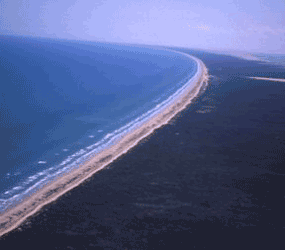
NPS photo The Gulf beach is composed of white sand and is less than a hundred feet wide, Much of it is firmly packed, except for a stretch of about forty miles which becomes increasingly soft towards the center and is composed to a large degree of shells. Bordering the beach is a narrow dune ridge running throughout the park and almost the length of the entire island. Sometimes natural or unnatural forces create breaches in the dune ridge and sand blows through creating "blowout" dunes, which may drift across the island at the rate of as much as 35 feet per year until they become vegetated. Sometimes dune fields form covering many acres. West of the dune ridge are the grasslands and marshes. Few trees exist on the island. Those that do are mostly mesquite, live oak, or willow. On the western shore of the island are extensive mudflats. |
Last updated: February 18, 2025