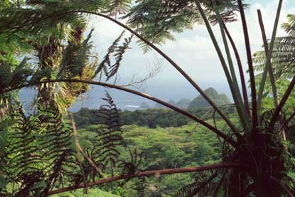
National Park Service LogoU.S. Department of the InteriorNational Park ServiceNational Park Service
National Park Service:  U.S. Department of the InteriorNational Park Service Arrowhead
National Park of American SamoaSamoan awa ceremony at Pago Pago
view map
text size:largestlargernormal
printer friendly
National Park of American Samoa
The Park
 
Tree fern frames a Tutuila landscape.
An NPS Photo by Gary Barbano.
A tree fern (Cyathea sp.) frames a view of the Pola Islands on Tutuila.
 

The National Park samples the best of American Samoa scenery, shorelines, reefs, and rainforest. In essence, it is really “three parks” on four separate islands. All the units have fine scenery and tropical rainforests. Lata Mountain on Ta’u excels in its wild and remote forests, free-flowing streams, and rugged coastline. Ofu and Olosega have the most accessible coral reefs and miles of breathtakingly beautiful beaches. Tutuila has road accessible forests, native wildlife, and scenic coastline.

All the four islands are extinct volcanoes heavily eroded to rugged peaks.  They were formed as the "Pacific plate" moved across a stationary hot spot where eruptions from the Earth's mantle pierced the lithosphere forming a line of volcanic islands.

Pola Islands, Tutuila
Tutuila unit.
The Tutuila unit is accessible by car from Pago Pago.
more...
 Sea cliffs of Lata Mountain on Ta'u
Ta'u Unit
Ta'u is accessible by air from Pago Pago.
more...
 Ofu beach and lagoon
Ofu, Olosega unit
The Ofu, Olosega unit is accessible by air from Pago Pago.
more...
 Old Faithful, Yellowstone National Park
Old Faithful, Yellowstone
The Samoa park is one in a "system" of national parks
more...
Pola Islands are a dominant feature of Tutuila Island’s rugged north coastline  

Did You Know?
American Samoa, the only U.S. territory south of the equator, consists of five rugged, highly eroded volcanic islands and two coral atolls. The land area of the territory is 76 square miles.

Last Updated: March 05, 2007 at 15:06 EST