Today, the National Park Service released the Stehekin River Corridor Implementation Plan and Final Environmental Impact Statement. The purpose of this plan is to address, in a comprehensive way, the steps needed to continue to provide high-quality recreational experiences, protect natural and cultural resources, support the private community of Stehekin, and establish sustainable administrative facilities - including access via the Stehekin Valley Road - as called for in the 1995 Lake Chelan National Recreation Area General Management Plan.
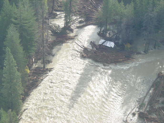
Major elements of the preferred alternative of the Stehekin River Corridor Implementation Plan and Final Environmental Impact Statement include the relocation of about two miles of the Stehekin Valley Road around flood-prone McGregor Meadows, a change to large wood management at the river mouth, and a revision of the 1995 Land Protection Plan to update priorities for land protection and federal land available for exchange. The preferred alternative would also make several new recreational opportunities available to the public, including a new raft take-out at the river mouth, a new campground at Rainbow Falls, and a Lower Valley Trail to connect the Stehekin Landing to High Bridge. Other important elements of the preferred alternative are carried forward from the 1995 Lake Chelan National Recreation Area General Management Plan, including moving the National Park Service maintenance facility and some National Park Service housing out of the floodplain.
Several changes were made in response to public input on the 2010 Draft Stehekin River Corridor Implementation Plan and Environmental Impact Statement. Proposed changes to the preferred alternative include a revised Land Protection Plan to more clearly focus on areas of greatest threat from flooding, the addition of an access road to McGregor Meadows from the road reroute, and an expanded socioeconomic analysis.
"We appreciate the public comments that have helped to shape this plan over the past four-plus years," said North Cascades National Park Complex Superintendent Chip Jenkins. "We have a better plan as a result."
Today's release of the Stehekin River Corridor Implementation Plan and Final Environmental Impact Statement will be followed by a 30-day no action period, which begins with the Environmental Protection Agency's notice of filing in the Federal Register. The complete Stehekin River Corridor Implementation Plan and Final Environmental Impact Statement and supplemental information are available at the SRCIP page.
The National Park Service is hosting two public information sessions about the Stehekin River Corridor Implementation Plan and Final Environmental Impact Statement. These will be held:
Monday, August 6 7:00 p.m. - 9:00 p.m.
Golden West Visitor Center
Stehekin
Tuesday, August 7 5:00 p.m. - 7:00 p.m.
Klondike Gold Rush National Historical Park
319 Second Avenue South
Seattle
Digital images and maps are available as a set at the North Cascades National Park Flickr site.